礁湖星云中的星际云,由哈勃太空望远镜拍摄 Interstellar clouds in the Lagoon Nebula, captured by the Hubble Space Telescope (© ESA/NASA)

礁湖星云中的星际云,由哈勃太空望远镜拍摄 Interstellar clouds in the Lagoon Nebula, captured by the Hubble Space Telescope (© ESA/NASA)
从前有一颗星星 Once upon a star
礁湖星云
宇宙生机勃勃,生生不息。图中的礁湖星云中,一个名为NGC 6530的星团正在孕育新生恒星,这光芒提醒着我们,宇宙的起源早已交织其中。它距离我们约4350光年,已有数百万年历史,目前仍处于恒星形成的早期阶段。
礁湖星云,在梅西耶星表中名列第八,简称M8,是一个位于南天人马座的发射星云(也可称之为电离氢区)。在NGC用表中排名6523,又称NGC 6523。这个星云是许多天文爱好者十分熟悉并且喜爱的天体之一,也是天文摄影的热门目标天体。礁湖星云充满炽热气体,是许多年轻恒星的家园,因其中心左侧的数道尘埃带而获得了礁湖星云的别名。
Carl Sagan Day
The universe hums with creation. Featured here, in the Lagoon Nebula, a cluster called NGC 6530 is kindling newborn stars, a glowing reminder that beginnings are woven into the fabric of the cosmos. About 4,350 light-years away and a few million years old, it is a stellar formation still in its earliest chapter.
The world celebrates Carl Sagan Day every November 9 to honor the astronomer who shared distant wonders through stories people could understand. Founded in 2009, the day is observed worldwide, marked by lectures, planetarium shows, and stargazing nights that carry Sagan's call for scientific curiosity.
Carl Sagan's legacy stretches from NASA's Voyager missions and the Golden Record to his Cosmos television series, inspiring millions to see science as both reason and a source of endless possibilities. At Cornell University, home to the Carl Sagan Institute, his vision continues through the search for habitable worlds and the celebration of cosmic discovery. In the night sky, NGC 6530 offers a fitting tribute: a nursery of suns forming within clouds of gas and dust, echoing Sagan's reminder that 'We are made of star stuff.'
班登海滩的海蚀柱,俄勒冈州,美国 Sea stacks of Bandon Beach in Bandon, Oregon (© Grant Ordelheide/TANDEM Stills + Motion)

班登海滩的海蚀柱,俄勒冈州,美国 Sea stacks of Bandon Beach in Bandon, Oregon (© Grant Ordelheide/TANDEM Stills + Motion)
班登的明星岩石 Rock stars of Bandon
俄勒冈州的班登海滩
驶出101号公路,俄勒冈州的班登便迎来了来访者,这里弥漫着咸咸的空气和轻柔的港口钟声。这座小镇始建于19世纪50年代,最初只是个小聚居地,后来发展成为木材和鲑鱼捕捞中心。蔓越莓成为当地的主要作物,至今仍是每年九月蔓越莓节的庆祝活动。老城区的木板路咖啡馆和画廊反映了那段历史,而科基尔河灯塔则矗立在布拉兹海滩,经过修复,依然屹立在那里,提醒着人们当年它曾指引船只的航向。
从灯塔步行一小段路即可到达海滩,那里展现着令人回味的海岸景观:班登的海蚀柱,正如今天图片中所展现的那样。这些地貌经过数千年的海浪、风蚀和缓慢崩塌的侵蚀,讲述着一段地质故事。面岩(Face Rock)形似当地传说中少女翘起的下巴。附近的巫师帽(Wizard's Hat)像一顶尖顶的帽子,直冲云霄;大象岩(Elephant Rock)拱起,如同一条伸向潮水的象鼻。其他值得注意的景观包括贝壳角(Coquille Point)、桌岩(Table Rock)以及猫和小猫(Cat and Kittens)海蚀柱。作为俄勒冈群岛国家野生动物保护区的一部分,这些海蚀柱为海鸟提供了庇护,并展现了海洋和时间的坚韧力量。
Bandon Beach in Bandon, Oregon
Pull off of Highway 101, and Bandon, Oregon, greets you with salty air and the clang of harbor bells. The town began as a small settlement in the 1850s and grew into a center for timber and salmon fishing. Cranberries became a key crop and are still celebrated each September during the Cranberry Festival. Old Town reflects that past with boardwalk cafés and galleries, while the Coquille River Lighthouse stands restored at Bullards Beach as a reminder of the days when its beacon guided ships.
A short walk from the lighthouse leads to the beach where an evocative coastal landscape unfolds: Bandon's sea stacks, featured in today's image. Sculpted over millennia by waves, wind, and the slow collapse of arches, these formations tell a geologic story. Face Rock resembles the tilted chin of a maiden from local legend. Nearby, Wizard's Hat rises like a pointed cap against the sky, and Elephant Rock arches like a trunk reaching for the tide. Other notable shapes include Coquille Point, Table Rock, and the Cat and Kittens stacks. Protected as part of the Oregon Islands National Wildlife Refuge, these stones shelter seabirds and reveal the patient force of ocean and time.
哈里朋柴佛塔寺的彩色灯笼, 南奔府, 泰国 Colorful lanterns at the temple of Wat Phra That Hariphunchai, Lamphun, Thailand (© MR. ANUJAK JAIMOOK/Getty Images)

哈里朋柴佛塔寺的彩色灯笼, 南奔府, 泰国 Colorful lanterns at the temple of Wat Phra That Hariphunchai, Lamphun, Thailand (© MR. ANUJAK JAIMOOK/Getty Images)
满天心愿 Sky full of wishes
庆祝义蓬节
如果一盏天灯能承载你的心愿,你会许下什么?今晚,在泰国北部,义蓬节为你带来这样的机会。这个延续数百年的兰纳传统,在农历十二月举行,人们点亮孔明灯以纪念佛陀。相传每一盏灯都能带走厄运,照亮通往美好未来的道路。孩子们扶稳灯架,长者低声祈福,成百上千的灯火缓缓升起,越过树梢,点亮夜空。同一轮满月下,南方的水灯节也在进行,烛光点点的花船在水面缓缓漂流。
在泰国北部的南奔府,有一座历史悠久的寺庙——哈里朋柴佛塔寺,它是欣赏义蓬节灯会的热门地点。寺庙的历史可以追溯到公元897年,当时哈里朋柴国王建造这座佛塔,用来供奉佛陀的一缕头发。佛塔至今仍矗立在寺院中央,周围的建筑则在后来的几个世纪逐渐完善,形成了如今的格局。寺庙的殿堂里,精美的木雕工艺展示了代代匠人的技艺。每年义蓬节期间,成千上万盏孔明灯缓缓升空,古老的祈愿与现代的祝福在夜空交织,让人仿佛穿越千年,感受文化与信仰的延续。
佩尼亚罗亚山毛榉森林, 蒙卡约自然公园, 萨拉戈萨, 阿拉贡, 西班牙 Peña Roya beech forest, Moncayo Natural Park, Zaragoza, Aragon, Spain (© David Santiago Garcia/DEEPOL by plainpicture)
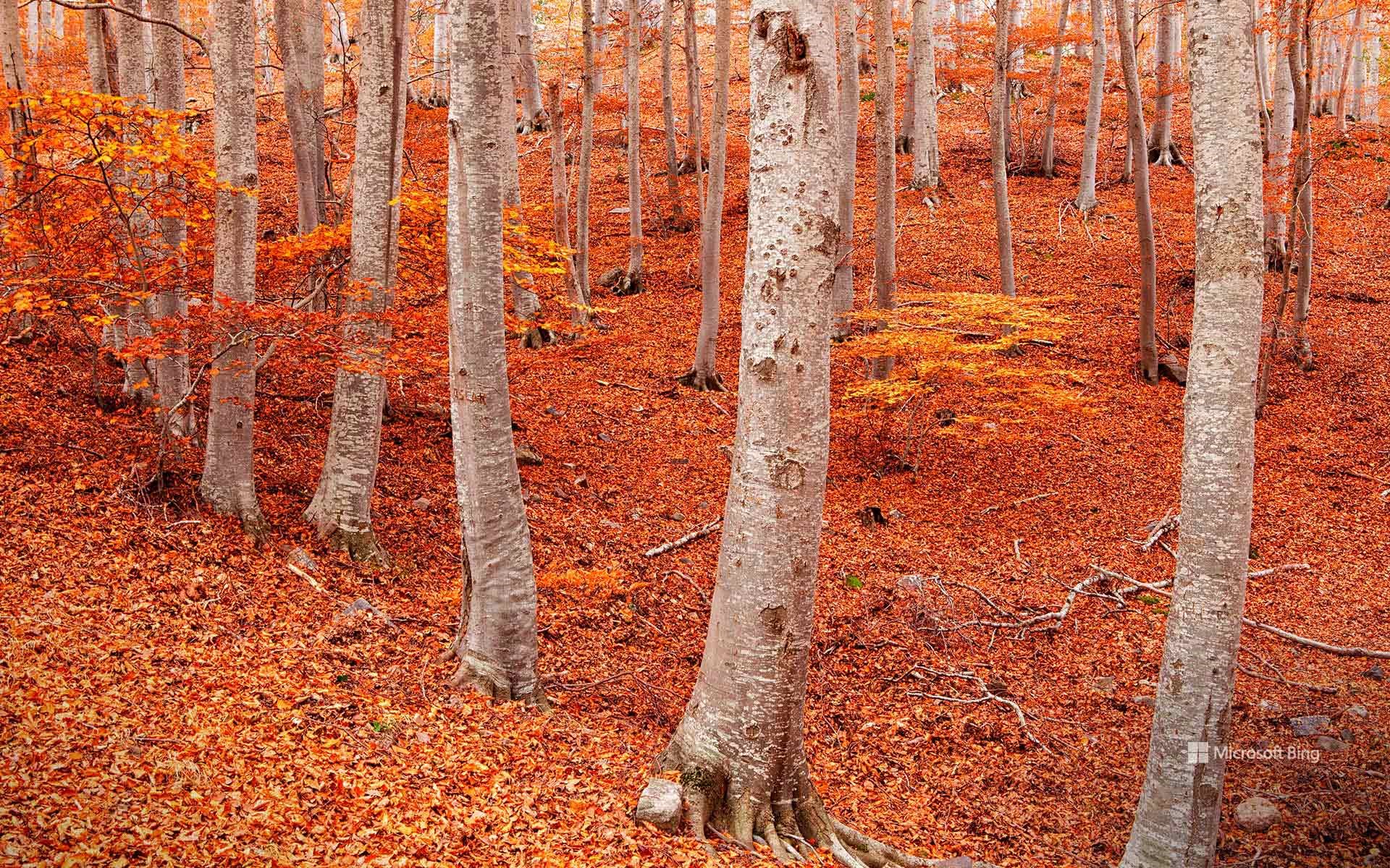
佩尼亚罗亚山毛榉森林, 蒙卡约自然公园, 萨拉戈萨, 阿拉贡, 西班牙 Peña Roya beech forest, Moncayo Natural Park, Zaragoza, Aragon, Spain (© David Santiago Garcia/DEEPOL by plainpicture)
秋天来了,你开心吗? Orange you glad it's fall?
佩尼亚罗亚山毛榉森林,西班牙
西班牙的阿拉贡地区,一般让人想到的是阳光和灌木,而不是森林的阴凉与静谧。然而,当你沿着蒙卡约山坡向上攀登,故事会出现意想不到的转折:一片浓密、低语的山毛榉林悄然迎面而来。这座山犹如气候过山车:山脚是地中海灌木,半山腰是橡树和松林,再往上,霎时间你便置身佩尼亚罗亚,这片山毛榉仙境仿佛在宣告:"由我来演绎秋天吧!"
秋天,是它们最耀眼的季节。森林像一床拼接的彩色被子,铺满红、金、橙的斑斓。徒步者踩着落叶,发出欢快的“咔嚓”声;鹿儿在林间轻盈穿行,野猪在灌木丛中拱食,苍鹰、金雕等猛禽的鸣叫,为这片山林配上了背景乐。正当你以为这里只有树木时,蒙卡约却展现出人文风情:山腰间隐匿着修道院,岩壁上依偎着小小的隐修所,还有那些曾把森林当作粮仓的古老村落。如今,人们来这里,不再是为了木材,而是为了徒步、拍照,和那一口甘甜的山间空气。
Peña Roya beech forest, Moncayo Natural Park, Aragon, Spain
Spain's Aragon region isn't exactly famous for its forests—it's more 'sun and scrub' than 'shade and shuffle.' And yet, climb the slopes of Moncayo and you'll walk straight into a twist ending: a dense, whispering beech forest. The mountain is a climate roller coaster. At the bottom? Mediterranean shrubs. Midway up? Oaks and pines. Push further? Suddenly you're in Peña Roya, a beech wonderland that seems to say, 'Surprise, leaf it to me!'
Fall is their show-off season. The forest becomes a patchwork quilt of red, gold, and orange, while hikers crunch happily through the leaves. Deer tiptoe through the trees, wild boar snuffle in the undergrowth, and birds like Eurasian goshawks and golden eagles supply the soundtrack. And just when you think it's all about trees, Moncayo reminds you of its human side: monasteries tucked into the mountainside, hermitages clinging to rocks, and villages that once treated the forest as their pantry. Today, people come not for timber, but for trails, photos, and that sweet mountain air.
塔桥, 伦敦, 英格兰 Tower Bridge, London, England (© Nick Brundle Photography/Getty Images)

塔桥, 伦敦, 英格兰 Tower Bridge, London, England (© Nick Brundle Photography/Getty Images)
小心空隙,桥面将开启! Mind the gap—this one opens
塔桥, 伦敦, 英格兰
有些桥梁只是连接两岸,而伦敦塔桥则连接着历史、工程与戏剧张力。自1894年起,这座伦敦地标矗立于伦敦塔旁,横跨泰晤士河,既能振奋人心,又能疏导交通。双塔矗立,蓝白相间的漆面,以及能像巨型吊桥般开启的活动桥面,塔桥不仅是交通解决方案,更像是一位舞台表演者。
在塔桥建成之初,伦敦需要一座不会阻碍河上贸易的跨河通道。解决方案是什么?一座能从中间分开并抬升到足够高度,让帆船顺利通过的桥梁。维多利亚时代的巧思,用蒸汽机驱动液压系统;如今,重任则由油压和电力承担。游客可以走进桥体,探索它的机房,并漫步在高空玻璃走道,俯瞰泰晤士河的壮丽景色。从哥特式双塔到可升起的活动桥面,这座建筑始终连接着过去与现在,印证着有时通往前方的最佳方式就是将阻碍高高抬起。
Tower Bridge, London, England
Some bridges connect two sides. Tower Bridge connects history, engineering, and a flair for drama. Standing next to the Tower of London and rising over the River Thames since 1894, this London icon literally knows how to lift spirits—and traffic. With its twin towers, blue-and-white paintwork, and bascules that open like a giant's drawbridge, Tower Bridge is less a traffic solution and more a stage performer.
When it was first built, London needed a crossing that wouldn't block river trade. The answer? A bridge that could split in half and rise high enough for sailing ships to pass through. Victorian ingenuity powered the hydraulics with steam engines; today, oil and electricity do the heavy lifting. Visitors can step inside to explore its engine rooms and stroll across the high-level glass walkways for a bird's-eye view of the Thames. From its Gothic-style towers to its lifting bascules, the structure continues to bridge the gap between past and present, proving that sometimes, the best way forward is to raise the road.
在太平洋中游泳的水母, 格雷罗, 墨西哥 Jellyfish swimming in the Pacific, Guerrero, Mexico (© Christian Vizl/TANDEM Stills + Motion)

在太平洋中游泳的水母, 格雷罗, 墨西哥 Jellyfish swimming in the Pacific, Guerrero, Mexico (© Christian Vizl/TANDEM Stills + Motion)
随波轻舞 Just jellin'
世界水母日
它们没有大脑、骨骼,甚至没有心脏,却已在地球海洋中游弋了五亿年。今天,世界水母日,这些摇曳生姿的奇妙生物终于迎来了属于它们的高光时刻——至少在海底世界如此。这一节日旨在推动保护水母栖息地,抵御污染、富营养化径流和海洋酸化等威胁。
别被它们名字里的“鱼”骗了:水母其实属于无脊椎动物门中的刺胞动物类,体内约95%是水。钟形躯体配上拖曳的触手,它们更像海洋中的漂泊者,而非深海健将。有些水母会发光,比如图中拍摄于墨西哥格雷罗外海的这一只;有些则带有毒刺;还有极少数,如“永生水母”,甚至能重置生命循环,重新开始。
水母是食物链中至关重要的环节,它们为海龟、太阳鱼和海鸟提供食物。其种群数量的突然激增也如同警报,提醒我们海洋因水温升高和过度捕捞而发生的变化。所以,今天让我们给予这些“无脑软体”应有的赞赏——它们比恐龙活得更久,精通漂流的艺术,并证明了有时候“没有脊梁”反而是一种力量。
World Jellyfish Day
They don't have brains, bones, or even hearts, yet jellyfish have pulsed through Earth's oceans for half a billion years. Today, on World Jellyfish Day, these wobbly wonders get their moment in the sun—or at least under the sea. The day promotes efforts to protect jellyfish habitats from threats like pollution, nutrient-rich runoff, and ocean acidification.
Don't be fooled by the 'fish' in their name: they belong to the invertebrate club called Cnidaria, and they're made up of about 95% water. With their bell-shaped bodies and trailing tentacles, they're more like ocean drifters than deep-sea athletes. Some glow like the one pictured here in the Pacific Ocean off Guerrero, Mexico, others pack stings, and a select few, like the 'immortal jellyfish,' can reset their life cycle and start again.
Jellyfish are vital links in the food chain, feeding turtles, sunfish, and seabirds. Their sudden population booms also act as alarms, signaling changes in the ocean caused by warming waters and overfishing. So today, let's give credit where credit is due—to the brainless blobs that have outlived dinosaurs, mastered the art of drifting, and proved that sometimes being spineless is actually a strength.
岚山缤纷的枫叶与竹林, 京都, 日本 Colorful maple leaves and bamboo forest in Arashiyama, Kyoto, Japan (© DoctorEgg/Getty Images)

岚山缤纷的枫叶与竹林, 京都, 日本 Colorful maple leaves and bamboo forest in Arashiyama, Kyoto, Japan (© DoctorEgg/Getty Images)
竹林吐纳清气,枫叶绚烂如火 Where bamboo breathes and maples blaze
日本京都岚山地区的枫林与竹林
今日,我们前往京都岚山地区,这里以迷人的四季风光闻名于世。此处,鲜艳的日本红枫与静谧的竹林交织出色彩与宁静的和谐画卷。这些以纤细深裂叶片著称的枫树,每逢秋日便幻化成炽烈的红、橙、金三色,吸引着全球游客纷至沓来。它们不仅因绝美姿态备受推崇,更承载着象征优雅、平和与生命无常的文化意蕴。
嵯峨野竹林同样具有标志性,高耸的真竹和毛竹在微风中轻轻摇曳。几个世纪以来,竹子一直是日本人生活中不可或缺的一部分,从建筑、手工艺到传统仪式,竹子都得到广泛应用。竹子的快速生长和韧性象征着力量和柔韧性,历史上人们种植竹林是为了抵御自然灾害。
Maple and bamboo forests in Arashiyama, Kyoto, Japan
Today, we travel to the Arashiyama district in Kyoto, renowned for its captivating seasonal landscapes. Here, vibrant Japanese maple trees and serene bamboo forests create a harmonious blend of color and tranquility. These maples, known for their delicate, deeply lobed leaves, turn fiery shades of red, orange, and gold during fall, attracting visitors from around the world. They are celebrated not only for their beauty but also for their cultural symbolism—representing elegance, peace, and the fleeting nature of life.
The Sagano Bamboo Forest is equally iconic, where towering stalks of madake and mosochiku varieties of bamboo sway gently in the breeze. Bamboo has been integral to Japanese life for centuries, used in everything from architecture and crafts to traditional ceremonies. Its rapid growth and resilience symbolize strength and flexibility, and bamboo groves were historically planted to protect against natural disasters.
野牛在温泉边吃草, 黄石国家公园, 怀俄明州, 美国 Bison grazing at thermal hot springs, Yellowstone National Park, Wyoming (© Cheryl Ramalho/Getty Images)
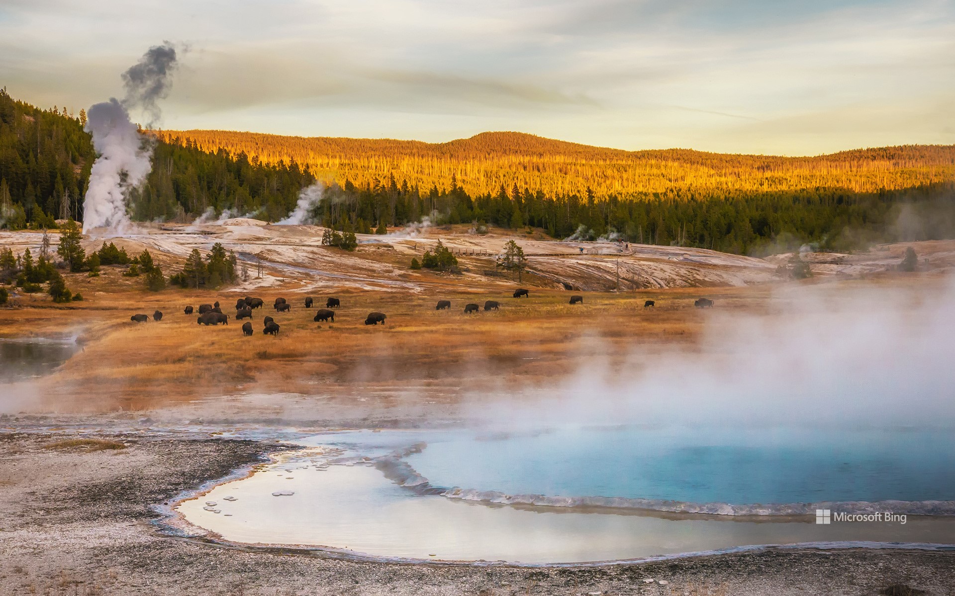
野牛在温泉边吃草, 黄石国家公园, 怀俄明州, 美国 Bison grazing at thermal hot springs, Yellowstone National Park, Wyoming (© Cheryl Ramalho/Getty Images)
古老血脉的兽群 Herds of heritage
黄石公园的野牛
野牛体现了一种矛盾:巨大的力量与沉静的气质并存。这些体型庞大的动物体重可达2000磅,身高6英尺(约1.8米),成群结队地漫游在北美的草原和河谷。这张照片拍摄于怀俄明州的黄石国家公园,它们的数量曾达数千万头,但在19世纪几乎灭绝——这一灭绝事件重塑了生态系统,扰乱了人们的生活方式。
对于无数原住民来说,这些动物一直被尊崇为导师、供养者和精神上的亲人,它们的每一部分都被精心利用,被用作食物、衣物、工具和燃料。正因如此,部落社区带头努力恢复草原、湿地和森林栖息地,形成由母牛、争吵的公牛和好奇的幼牛领导的社会群体。
站在它们面前,感受古老、中断与复兴在一瞬间交汇。野牛的幸存提醒我们,遗产不仅被铭记,它还被传承,交织在崎岖的地貌和经久不衰的传统之中。
National Bison Day
The bison embodies a paradox: immense strength paired with quiet calm. Weighing up to 2,000 pounds and standing 6 feet tall, these giants roam North America's grasslands and river valleys in mobile herds. Photographed here in Yellowstone National Park, Wyoming, they once numbered in the tens of millions but were nearly eradicated in the 19th century—a loss that reshaped ecosystems and disrupted lifeways.
Today, on National Bison Day, observed each year in early November, we honor this iconic species' persistence and profound significance. It's only fitting that this celebration falls at the start of Native American Heritage Month: for countless Native Nations, these animals have been revered as teachers, providers, and spiritual relatives, with every part used thoughtfully for sustenance, clothing, tools, and fuel. That's why tribal communities lead efforts to help them reclaim prairie, wetland, and forest habitats, forming social herds led by matriarchs, sparring males, and curious calves.
布兰城堡入口, 布拉索夫, 罗马尼亚 Entrance of Bran Castle in Bran, Brașov, Romania (© blue sky in my pocket/Getty Images)
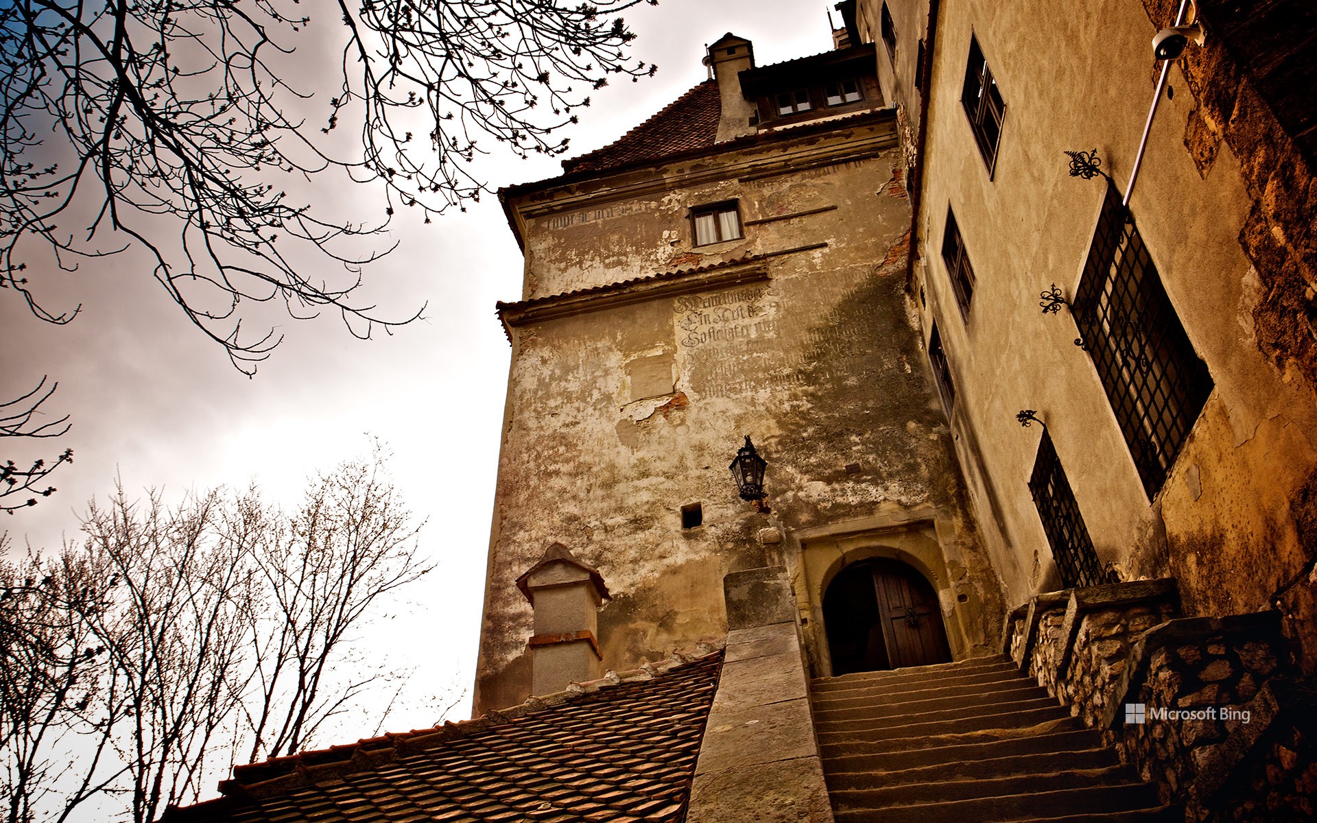
布兰城堡入口, 布拉索夫, 罗马尼亚 Entrance of Bran Castle in Bran, Brașov, Romania (© blue sky in my pocket/Getty Images)
在万圣节的魔咒之下 Under the Halloween spell
万圣节快乐!
今夜,万圣节的魔咒笼罩大地——而地球上仅有少数地方能与罗马尼亚的布兰城堡比肩,承载着如此深邃的谜团。这座建于14世纪的堡垒历经战火洗礼,见证君王更迭与帝国兴衰。但在此地,传说比历史更响亮。这座城堡坐落于以阴森传说闻名的特兰西瓦尼亚与昔日由弗拉德三世·德古拉统治的瓦拉几亚之间,散发着令人心悸的遗迹气息。弗拉德的残暴名声启发了布拉姆·斯托克1897年创作的小说《德古拉》。尽管故事背景并非布兰城堡,但它巍峨的轮廓与关于弗拉德幽灵出没的传闻,让真实与传说交织模糊,永远将这座城堡与人类最持久的传说之一紧密相连。
故事书的篇章之外,布兰城堡还低语着许多幽灵传说。据当地传闻,哀伤的白衣女子在庭院中飘荡;被封墙困住的僧侣脚步声在墙后回响;看不见的孩子们嬉闹的笑声在走廊间流转。闪烁的幽光、骤起的寒意与无形之声的传闻,更添几分不安。值此万圣之夜,布兰城堡的灵魂已超越石砌的躯壳。记忆在此扭曲成神话,现实与超自然的界限变得惊心动魄地模糊。
Happy Halloween!
Tonight, Halloween casts its spell—and only a few places on Earth carry a mystery quite like Bran Castle in Romania. The fortress was built in the 14th century and has withstood wars, monarchs, and shifting empires. But here, legends speak louder than history. Perched between the regions of Transylvania—renowned for its chilling tales—and Wallachia, once ruled by Vlad III Dracula, the castle evokes a haunting legacy. Vlad's ruthless reputation inspired Bram Stoker's 1897 Gothic novel 'Dracula.' Though the story is not set at Bran Castle, its looming form and persistent rumors of Vlad's presence blur fact and legend, forever linking it to one of humanity's most enduring tales.
Beyond the pages of storybooks, Bran Castle whispers many other haunted narratives. According to local accounts, the sorrowful White Lady drifts through the courtyard; a monk's muffled steps echo from behind the walls that sealed him in; and the playful laughter of unseen children carries through the corridors. Reports of flickering lights, sudden chills, and disembodied voices heighten the unease. On this Halloween, Bran Castle rises beyond the stones that shape it. Here, memory twists into myth, and the line between reality and the supernatural grows thrillingly thin.
杰伊瑟尔梅尔的骆驼, 拉贾斯坦邦, 印度 Camels at Jaisalmer, Rajasthan, India (© f9photos/Getty Images)
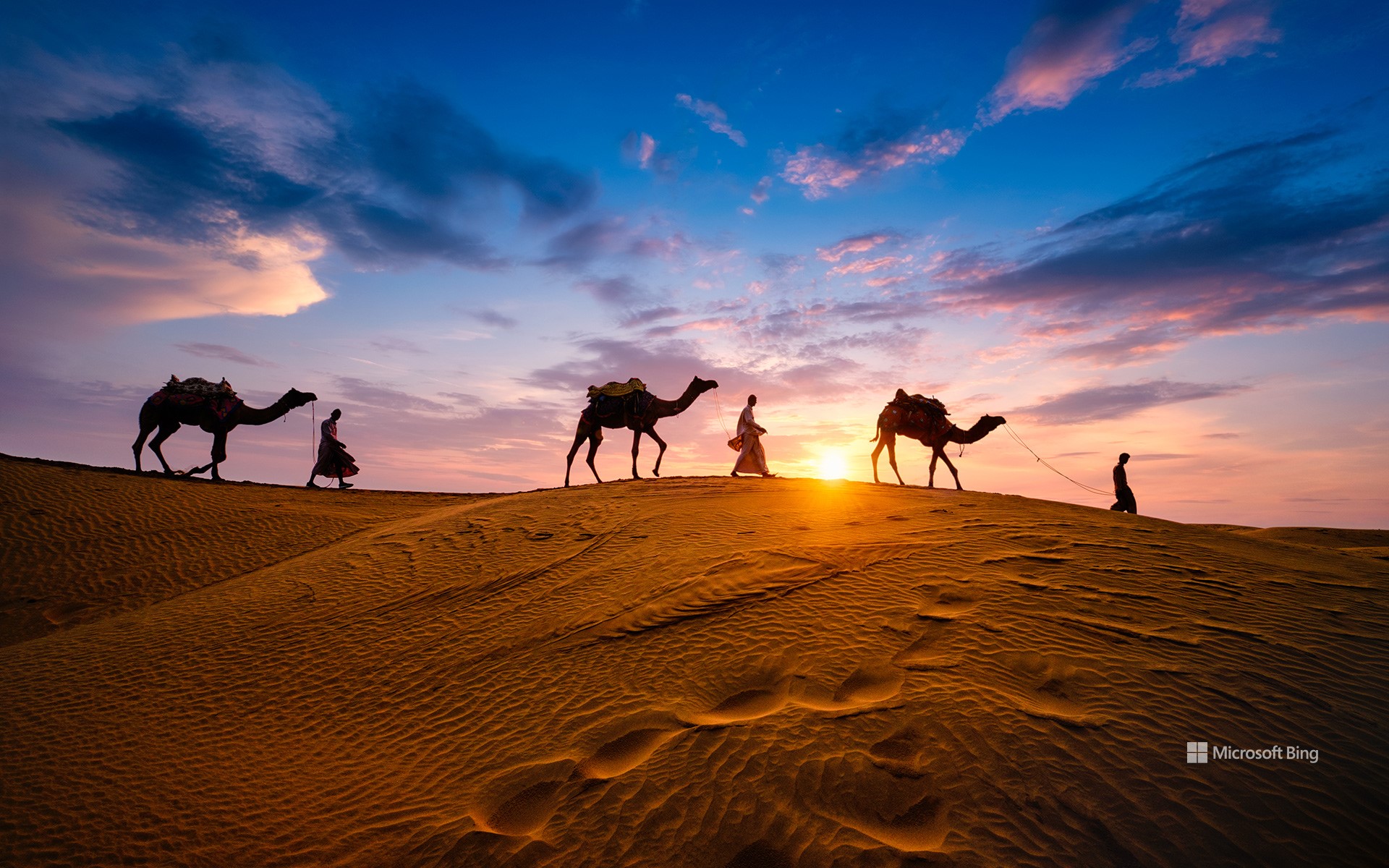
杰伊瑟尔梅尔的骆驼, 拉贾斯坦邦, 印度 Camels at Jaisalmer, Rajasthan, India (© f9photos/Getty Images)
蹄声、色彩与传承 Hooves, hues, and heritage
普什卡骆驼节
每到秋季,印度拉贾斯坦邦的沙漠小镇普什卡都会因一场普什卡骆驼节而热闹非凡。这一节庆与印度教的卡提克月相对应,通常在公历10月下旬至11月初举行。今年的庆典自今日起至11月5日,成为了当地一年中最令人期待的季节。
最初,这里是世界上最大的骆驼和牛只交易市场之一,而今已逐渐演变为文化与社区的盛大节日。除了牲畜交易,游客还能欣赏到趣味竞赛,如“打陶罐”、最长胡须比赛,甚至还有新娘秀。农村家庭在五彩缤纷的集市间穿梭,摊位上摆满了纺织品、衣物和闪亮的手镯。盛会以热闹的骆驼赛跑拉开帷幕,接着是传统歌曲、舞蹈和各类表演。最受瞩目的活动之一是骆驼展示,参与者依次骑上骆驼,热闹非凡,烘托出浓郁的节日氛围。近年来,集市还增添了新亮点,比如由当地普什卡俱乐部与外国游客组成球队进行的一场友谊足球赛,让节庆气氛更加多元。
Camels at Jaisalmer, Rajasthan, India
Every fall, the desert town of Pushkar in Rajasthan, India, comes alive with one of the most colorful gatherings—the Pushkar Camel Fair. Timed with the Hindu lunar month of Kartik, it usually takes place between late October and early November on the Gregorian calendar. This year, the celebrations stretch from today until November 5, marking the region's most anticipated season.
What began as one of the world's largest camel and cattle markets has gradually transformed into a grand celebration of culture and community. Alongside the trading of cattle and camels, visitors now enjoy quirky competitions like 'matka phod' (pot breaking), longest mustache contest, and even bridal shows. Rural families explore vibrant stalls overflowing with textiles, clothes, and glittering bracelets, while the fair itself kicks off with a high-spirited camel race, followed by traditional songs, dances, and lively performances. Among the highlights is the camel showcase, where participants take turns riding the animals in an animated display that adds to the festive charm. In recent years, the fair has introduced new attractions too, including a friendly football match between the local Pushkar Club and teams of foreign tourists.