泰瑞尔湖,维多利亚州,澳大利亚 Lake Tyrrell, Victoria, Australia (© Monica Bertolazzi/Getty Images)

泰瑞尔湖,维多利亚州,澳大利亚 Lake Tyrrell, Victoria, Australia (© Monica Bertolazzi/Getty Images)
大地之盐 Salt of the earth
泰瑞尔湖,维多利亚州,澳大利亚
澳大利亚南部的泰瑞尔湖,是天空与大地交汇之地,形成了令人炫目的奇景。泰瑞尔湖是维多利亚州最大的盐湖,形成于约12万年前。随着气候变化,湖泊水位逐渐下降,如今大部分时间干涸,仅在冬季覆盖约2英寸的水层。“泰瑞尔”这个名字源自当地沃加亚语中的“天空”,致敬了博罗恩原住民对天文学的浓厚兴趣。泰瑞尔湖面积超过70平方英里,是野生动物的天堂,栖息着马利地区的爬行动物、袋鼠和鸸鹋。
近年来,泰瑞尔湖已成为热门旅游景点。每年冬季,世界各地的游客慕名前来,湖面如镜,映照无垠的澳大利亚天空,是理想的拍照胜地。湖底盐层的独特景观也为摄影增添了绝佳背景。每到夜晚,这里成为观星胜地,人们在此仰望南半球的星座,感叹夜空的壮丽。
Lake Tyrrell, Victoria, Australia
At Lake Tyrrell, in southern Australia, the sky meets the Earth in a dazzling display. The state of Victoria's largest salt lake was formed around 120,000 years ago. Over time, climate changes caused water levels to drop; these days, the lake is normally dry, except in winter when it's covered in about 2 inches of water. The name 'Tyrrell' comes from the local Wergaia word for 'sky,' a nod to the Boorong Aboriginal People's interest in astronomy. Spanning more than 70 square miles, Lake Tyrrell is a haven for wildlife, including kangaroos, emus, and various reptiles.
In recent years, the lake has become a tourist hotspot. People come from all over the world during the winter months, drawn by its mirror-like surface that reflects the endless Australian sky, making it the perfect photo op. Salt formations on the lakebed also provide a stunning backdrop for photographs. At night, it becomes the perfect place for stargazing, offering the chance to marvel at the constellations of the Southern Hemisphere.
上海豫园的灯会,元宵节,上海市,中国 Colorful lanterns in Yuyuan garden, Lantern Festival, Shanghai, China (© atiger/Shutterstock)
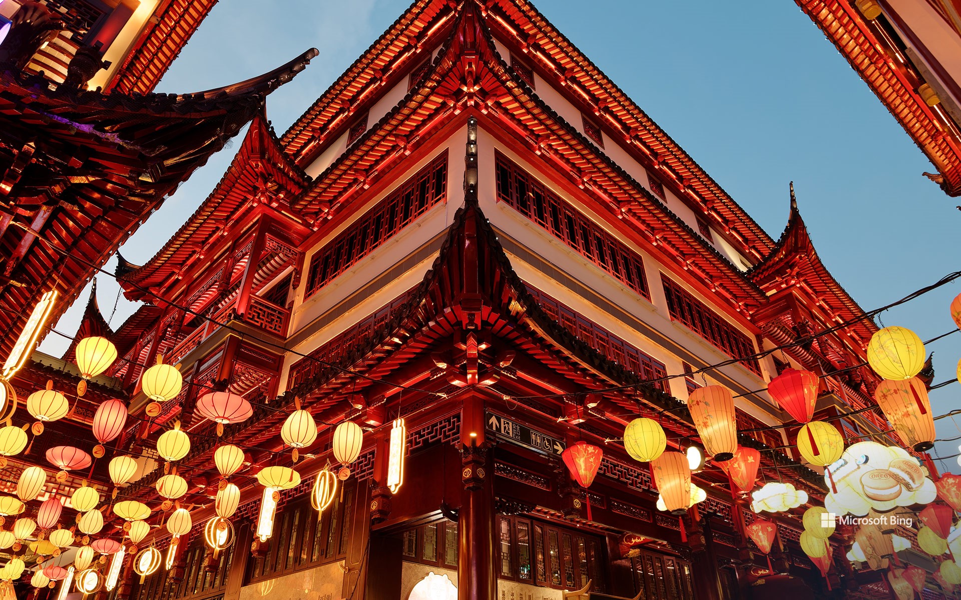
上海豫园的灯会,元宵节,上海市,中国 Colorful lanterns in Yuyuan garden, Lantern Festival, Shanghai, China (© atiger/Shutterstock)
喜气洋洋的元宵节 Dreamy and colorful lanterns
元宵节
元宵节(Lantern Festival),是新年第一个月圆之夜,又可以称为“闹元宵”,是中国春节年俗活动的“压轴戏”。人们在这一天可以出门赏月、燃灯放焰、喜猜灯谜、共吃元宵、汤圆,合家团聚、同庆佳节,其乐融融。观赏花灯是中国人在这一天一项重大活动。上海豫园的灯会尤其精彩。
2025年豫园灯会是于2025年1月1日至2月12日期间举办的活动。今年灯会的主题是奇妙的 “山川众生”。它展现了丛林中包罗万象、生机勃勃的神奇景象。
云冈石窟,大同,山西省,中国 Yungang Grottoes, Datong, Shanxi province, China (© Eric Yang/Getty Images)

云冈石窟,大同,山西省,中国 Yungang Grottoes, Datong, Shanxi province, China (© Eric Yang/Getty Images)
历史的守望之眼 The watchful eyes of history
云冈石窟,大同,中国
云冈石窟中汇聚了51,000尊古代雕像,这座早期佛教艺术杰作位于中国山西省大同市附近。石窟开凿于1500多年前的北魏时期(公元386-534/535年),现存主要洞窟45个,附属洞窟209个。最引人注目的是第5窟中的巨大佛像,高达56英尺,令人叹为观止。这只是冰山一角,每个洞窟都展现其独特魅力。有些洞窟宛如古代画卷,描绘佛教经典故事;另一些则展示僧侣、神祇、乐师,甚至北魏时期的日常生活场景。
第16至20窟被称为‘昙曜五窟’,是云冈石窟最早开凿的洞窟,由高僧昙曜主持修建。游览时,千万不要错过第20窟中呈冥想姿态的露天大佛,其旁还有一尊站立的侍佛像。这些洞窟融合了印度、中亚及中国本土佛教艺术风格,呈现出文化交融的壮丽奇观。无论是历史爱好者还是艺术鉴赏家,云冈石窟都将带来一次难忘的体验。
Yungang Grottoes, Shanxi, China
What do 51,000 ancient statues have in common? They all call the Yungang Grottoes in China home! This collection of early Buddhist art is near Datong in Shanxi province, northeastern China. Carved into sandstone cliffs over 1,500 years ago during the Northern Wei dynasty, the grottoes comprise 254 caves. The highlight is the massive Buddha in Cave 5, which is a jaw-dropping 56 feet tall. But don't stop there—each cave offers something unique. Some are like ancient storyboards, depicting tales from Buddhist scriptures, while others showcase detailed carvings of monks, deities, musicians, and even scenes of daily life under Wei rule. These caves blend influences from Indian, Central Asian, and local Chinese Buddhist art. Whether you're a history lover or simply appreciate unique art, the Yungang Grottoes offer an unforgettable experience.
阿尔斯特罗姆角,鲍威尔湖,犹他州,美国 Alstrom Point, Lake Powell, Utah (© T.M. Schultze/TANDEM Stills + Motion)
阿尔斯特罗姆角,鲍威尔湖,犹他州,美国 Alstrom Point, Lake Powell, Utah (© T.M. Schultze/TANDEM Stills + Motion)
值得深思的高地 A point worth pondering
阿尔斯特罗姆角,鲍威尔湖
如果你向往壮丽的日落和令人惊叹的美景,不妨来到阿尔斯特罗姆角。阿尔斯特罗姆角位于犹他州南部凯恩县的格伦峡谷国家休闲区,海拔达4685英尺。阿尔斯特罗姆角主要由恩特拉达砂岩构成,与附近的罗马纳梅萨主峰及东侧的冈赛特山共享相同的地质起源。
作为鲍威尔湖地区的一部分,阿尔斯特罗姆角向南延伸至湖泊辽阔水域,位于帕德雷湾与沃姆溪湾之间。湖水蓄满时,阿尔斯特罗姆角高出水面近1000英尺,可俯瞰周围峡谷。鲍威尔湖横跨犹他州与亚利桑那州,每年吸引约300万游客前来。这片湖泊由深蓝色水流组成迷宫般的网络,蜿蜒穿过90多个岩石峡谷。湖泊的主要部分流经格伦峡谷,同时延伸至多个较小支流峡谷,以及埃斯卡兰特河与圣胡安河区域。
Alstrom Point, Lake Powell, Utah
If you're chasing sunsets and jaw-dropping views, come to Alstrom Point. Located in southern Utah's Kane County, this spot in the Glen Canyon National Recreation Area stands at an impressive height of 4,685 feet. Made mostly of Entrada Sandstone, it has the same geological roots as nearby sites like Romana Mesa, its parent peak, and Gunsight Butte, another sandstone summit to the east.
Part of the Lake Powell region, Alstrom Point extends southward into the vast waters of the lake, in between Padre Bay and Warm Creek Bay. When the lake is full, Alstrom Point towers nearly 1,000 feet above the water, offering views of the surrounding canyons. Lake Powell, spanning across Utah and Arizona, attracts around 3 million visitors every year. The lake is a maze of deep blue water winding through over 90 rock canyons. While its main stretch runs through Glen Canyon, it also snakes into over many smaller side canyons, along with the Escalante and San Juan Rivers.
梅斯蒂亚的中世纪塔楼,上斯瓦涅季,格鲁吉亚 Medieval towers in Mestia, Upper Svaneti, Georgia (© photoaliona/Getty Images)
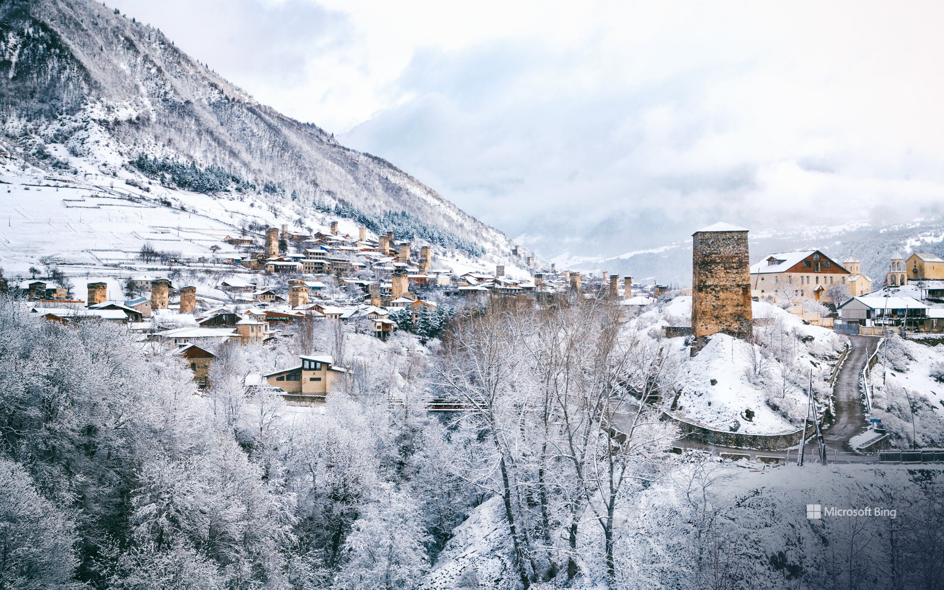
梅斯蒂亚的中世纪塔楼,上斯瓦涅季,格鲁吉亚 Medieval towers in Mestia, Upper Svaneti, Georgia (© photoaliona/Getty Images)
凝固的时光 Frozen in time
梅斯蒂亚的中世纪塔楼,上斯瓦涅季,格鲁吉亚
冬季为梅斯蒂亚的中世纪塔楼披上冰雪,宛如一座座坚固的堡垒。梅斯蒂亚坐落于高加索山脉,海拔4921英尺,是格鲁吉亚西北部一座迷人的高原小镇。小镇是斯万人的故乡,他们是格鲁吉亚文化和语言的一个独特分支。尽管规模不大,梅斯蒂亚数百年来一直是格鲁吉亚文化的枢纽,小镇遍布斯万族的防御塔,如今日图片所示。这些防御塔大多建于9至12世纪,这一时期被誉为格鲁吉亚的黄金时代。据推测,这些塔楼的历史可能追溯至更久远的史前时期。塔楼不仅是防御工事,也是家庭住宅的重要组成部分,反映了该地区坚韧不拔、自给自足的历史。因此,梅斯蒂亚不仅是一座小镇,更是一个活的博物馆,其历史从塔楼中升起,回荡在高山之间。
Medieval towers in Mestia, Upper Svaneti, Georgia
Winter turns Mestia's medieval towers into icy fortresses. Perched 4,921 feet up in the Caucasus Mountains, Mestia is a charming highland town in the Eastern European country of Georgia. The town is home to the Svans, a cultural and linguistic subgroup of Georgians.
Despite its modest size, Mestia has been an essential hub of Georgian culture for centuries, dotted with the Svan defensive towers seen in today's image. Most of these towers were constructed between the 9th and 12th centuries, a period often referred to as Georgia's Golden Age. However, their roots are believed to stretch even further back, possibly into prehistoric times. Built for both protection and shelter, the towers were not just fortresses but also integral parts of family homes, reflecting the region's history of resilience and self-sufficiency. Mestia isn't just a town; it's a living museum where history rises from the towers and echoes through the mountains.
特隆赫姆的蓝色时刻,挪威 Blue hour in Trondheim, Norway (© Jeanny Mueller/Getty Images)
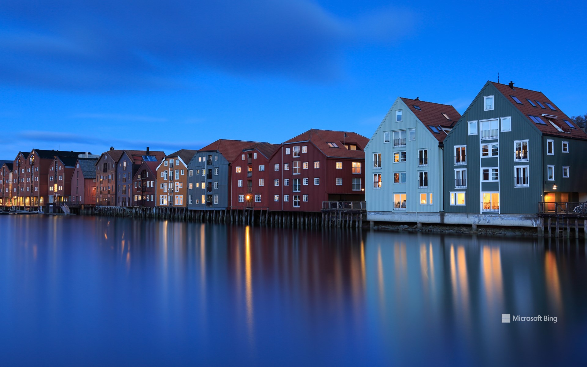
特隆赫姆的蓝色时刻,挪威 Blue hour in Trondheim, Norway (© Jeanny Mueller/Getty Images)
沉浸在蓝调时分 Stuck in a blue moment
特隆赫姆的蓝色时刻,挪威
在挪威,冬季不仅是一个季节,更是一种独特的体验。在挪威北部,黑夜长达20小时,有时甚至整周太阳都隐匿在地平线之下。这听起来或许有些阴郁,但这种特殊的时节也展现出独特的魅力。通常在下午1点至2点之间,柔和的光线从白雪覆盖的地面和深蓝色海面反射而来。这形成了一种令人惊叹的如玻璃般湛蓝的光辉,笼罩着整片大地。这种蓝调时分每天都会来得稍晚一些,温柔地提醒人们太阳正缓缓准备重新升起。
今日图片展示了特隆赫姆的蓝调时分。这座城市位于特隆赫姆峡湾南岸,环绕着尼达河的柔和曲线。特隆赫姆建于公元997年,最初是一个贸易站,在维京时代曾为挪威首都,直至1217年。特隆赫姆的沿海气候使冬季相对温和,但其周边山丘地带的微气候更为寒冷多雪,是冬季运动爱好者的理想之地。
Blue hour in Trondheim, Norway
In Norway, winter isn't just a season—it's an experience. In the north of the country, nights stretch for 20 hours, and there are entire weeks when the sun remains hidden below the horizon. It might sound bleak, but it's a unique time of the year. Why? Because around early afternoon, usually between 1 and 2 PM, a soft, lingering light reflects off the snow-covered ground and the deep blue sea. This forms a breathtaking, glassy blue glow that settles over the landscape. Each day, the blue hour arrives just a little later, a gentle reminder that the sun is slowly preparing to reclaim the sky.
Featured here is Trondheim's blue hour. The city lies on the southern shore of the Trondheimsfjord and is framed by the gentle curves of the Nidelva River. Founded in 997 CE as a trading post, Trondheim was Norway's capital during the Viking Age and remained so until 1217. While its coastal climate keeps winters relatively mild, Trondheim's nearby hills offer a colder, snowier microclimate perfect for winter sports enthusiasts.
拱门群岛,瓦拉里基海滩,南岛,新西兰 Archway Islands, Wharariki Beach, South Island, New Zealand (© Francesco Vaninetti/AWL/plainpicture)
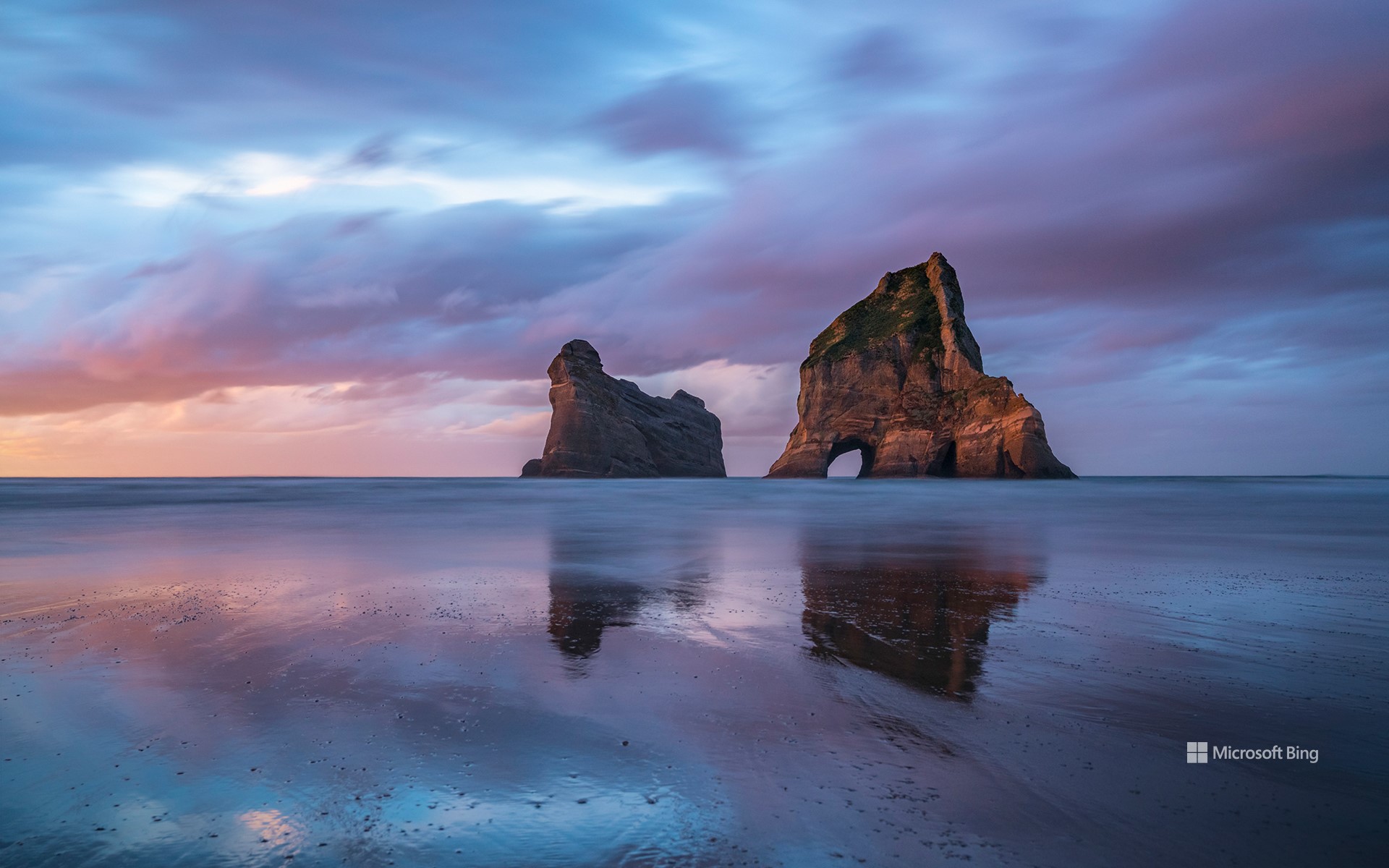
拱门群岛,瓦拉里基海滩,南岛,新西兰 Archway Islands, Wharariki Beach, South Island, New Zealand (© Francesco Vaninetti/AWL/plainpicture)
对国家遗产的思考 Reflections of a nation's legacy
新西兰的怀唐伊日
1840年,500多位毛利酋长与英国王室代表共同签署了一份条约,新西兰人至今仍在怀唐伊日纪念这一历史时刻。这一天,签署的《怀唐伊条约》确立了两种文化共存的原则。在怀唐伊条约签署地,庆典活动包括毛利传统表演、演讲和精彩的独木舟比赛。从奥克兰和惠灵顿的节日与音乐会,到低调的社区聚会,这一天的核心精神是联系与文化。
庆祝新西兰历史的最佳方式是什么?就是在如同明信片般美丽的地方度过这一天。今日图片展示的拱门岛位于瓦拉瑞基海滩,这些岩石群从塔斯曼海中拔地而起,外形崎岖壮丽。2015年,这些岩石因出现在Windows 10桌面屏保中而闻名全球。退潮时,游客可以探索洞穴和潮汐岩池,还常常能看到悠闲晒太阳的海豹。怀唐伊日不仅纪念历史,更是对文化与自然的庆典!
Waitangi Day in New Zealand
What do you get when you bring together more than 500 Māori chiefs, representatives of the British Crown, and a treaty signed in 1840? A day that New Zealanders still commemorate: Waitangi Day. On this date, the Treaty of Waitangi was signed, establishing the principles for how the two cultures would coexist. Ceremonies are held at Waitangi Treaty Grounds—where the document was signed—featuring traditional Māori performances, speeches, and the ever-dramatic waka (canoe) races. From festivals and concerts in cities like Auckland and Wellington to low-key community gatherings, the spirit of the day is about connection and culture.
What's better than celebrating New Zealand's history on Waitangi Day? Doing it in a place that looks straight out of a postcard. Enter the Archway Islands, a group of four rock stacks at Wharariki Beach, as seen in today's image. Rising from the waters of the Tasman Sea, these rugged islets became well known around the world after they were featured in a Windows 10 desktop screensaver in 2015. At low tide, curious wanderers can explore caves and rock pools and often spot lounging seals.
国王岩堡垒 , 瑞士撒克逊, 德国 Königstein Fortress, Saxon Switzerland, Germany (© Bildagentur-online/Exss/Alamy)
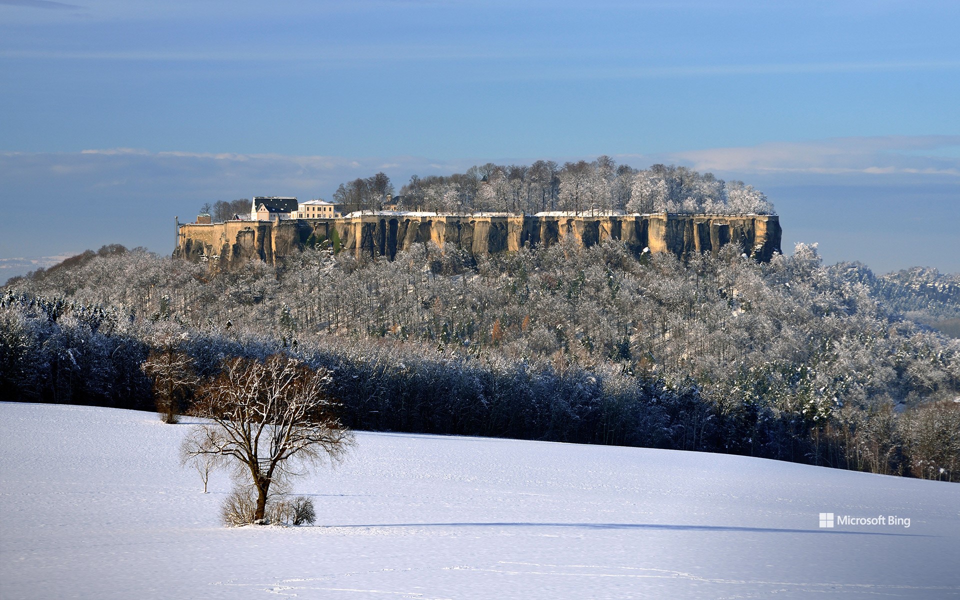
国王岩堡垒 , 瑞士撒克逊, 德国 Königstein Fortress, Saxon Switzerland, Germany (© Bildagentur-online/Exss/Alamy)
雪与石 Snow and Stone
国王岩堡垒,瑞士撒克逊,德国
作为欧洲最壮观的山地要塞之一,它耸立于易北砂岩山脉之巅。历史记录显示,1233年波希米亚国王温塞斯拉斯一世的文件首次提及这座堡垒,当时称其为施泰因的总督堡,推测即为国王岩堡垒。当时,这片区域属于波希米亚王国。16世纪,这座城堡经过大规模扩建,逐步发展为萨克森州立要塞。1566年至1569年,堡内建造了一口深达152.5米的井,这也是德国最深的历史古井之一,标志着要塞发展的重要里程碑。此外,首位国家囚犯马丁·米鲁斯博士的囚禁,揭开了堡垒作为监狱的历史篇章。
德累斯顿五月起义期间,国王岩堡垒再次成为萨克森王室的避难所。起义被镇压后,革命者被囚禁于要塞的国家监狱。一战和二战期间,这里曾被用作大型战俘营。1955年后,要塞被用作青少年犯罪改造中心,随后开放为博物馆,吸引无数游客参观。冬季,国王岩堡垒化身童话般的冰雪仙境,冰霜将古老城墙装点得晶莹剔透,宛如艺术品。这座自然与人文交融的瑰宝,曾启发德国画家卡斯帕·大卫·弗里德里希创作名画《雾海上的旅人》。
罗兰多山口,奥德萨和佩迪多山国家公园,西班牙 La Brecha de Rolando, Ordesa y Monte Perdido National Park, Spain (© Inaki Relanzon/Nature Picture Library/Alamy Stock Photo)
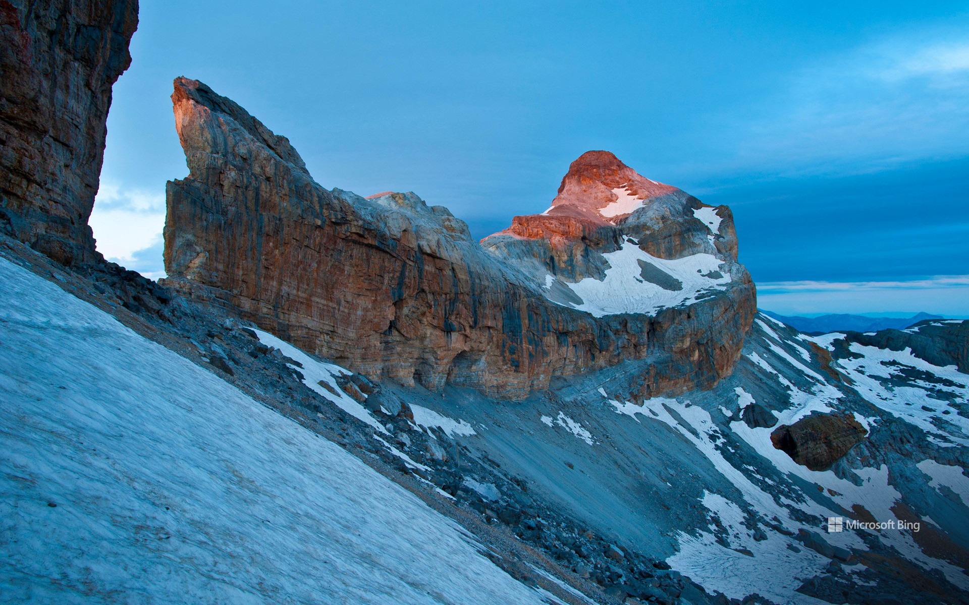
罗兰多山口,奥德萨和佩迪多山国家公园,西班牙 La Brecha de Rolando, Ordesa y Monte Perdido National Park, Spain (© Inaki Relanzon/Nature Picture Library/Alamy Stock Photo)
再次冲向战斗 Once more unto the breach
罗兰缺口,西班牙
在比利牛斯山脉高处,有一个山间缺口,罗兰缺口。这道缺口高约300 多英尺,宽 131 英尺,是令人惊叹的自然奇观。那么罗兰是谁?他是公元八世纪查理曼大帝统治时期的法兰克军事领袖。传说他在战败后用剑在山脉砍出一个缺口,有人说是为了毁掉自己的宝剑,也有人说是为了最后再看一眼祖国法兰西。
罗兰缺口位于西班牙的奥德萨和佩迪杜山国家公园,紧邻法国边界。公园面积超过38,000英亩,以壮观的石灰岩地貌闻名。公园包括四个各具特色的山谷和一座海拔超过11,000英尺的蒙特佩尔杜山峰。这座山峰还拥有自己的冰川蒙特佩尔杜冰川,为比利牛斯山脉第四大冰川。这片崎岖的山区栖息着丰富的野生动物,包括野猪、比利牛斯羚羊和棕熊。这里既是地质奇观,也是一片野生动植物的天堂。
Roland's Breach, Spain
High up in the Pyrenees, there is a gap in the mountains. More than 300 feet tall and 131 feet across, La Brecha de Rolando (Roland's Breach), featured here today, is a sight to behold. But who was Roland? Count Roland was a Frankish military leader during Charlemagne's reign in the 8th century. Legend has it that, after being defeated in battle, Roland cut a gap in the mountains—either to destroy his sword or to catch one last glimpse of France.
Roland's Breach lies within the Ordesa y Monte Perdido National Park in Spain, right on the border with France. Covering more than 38,000 acres, the park is home to some spectacular limestone formations. It's made up of four different valleys and one peak—Monte Perdido—which towers more than 11,000 feet above sea level. It even has its own glacier, the Monte Perdido glacier, which is the fourth largest in the Pyrenees. A wide range of animals live in this mountainous landscape, including wild boars, Pyrenean chamois, and brown bears.