斯托尔石山,天空之岛,苏格兰 (© Aliaume Chapelle/Tandem Stills + Motion)
斯托尔石山,天空之岛,苏格兰 (© Aliaume Chapelle/Tandem Stills + Motion)
天空之岛
斯托尔山,天空之岛,苏格兰
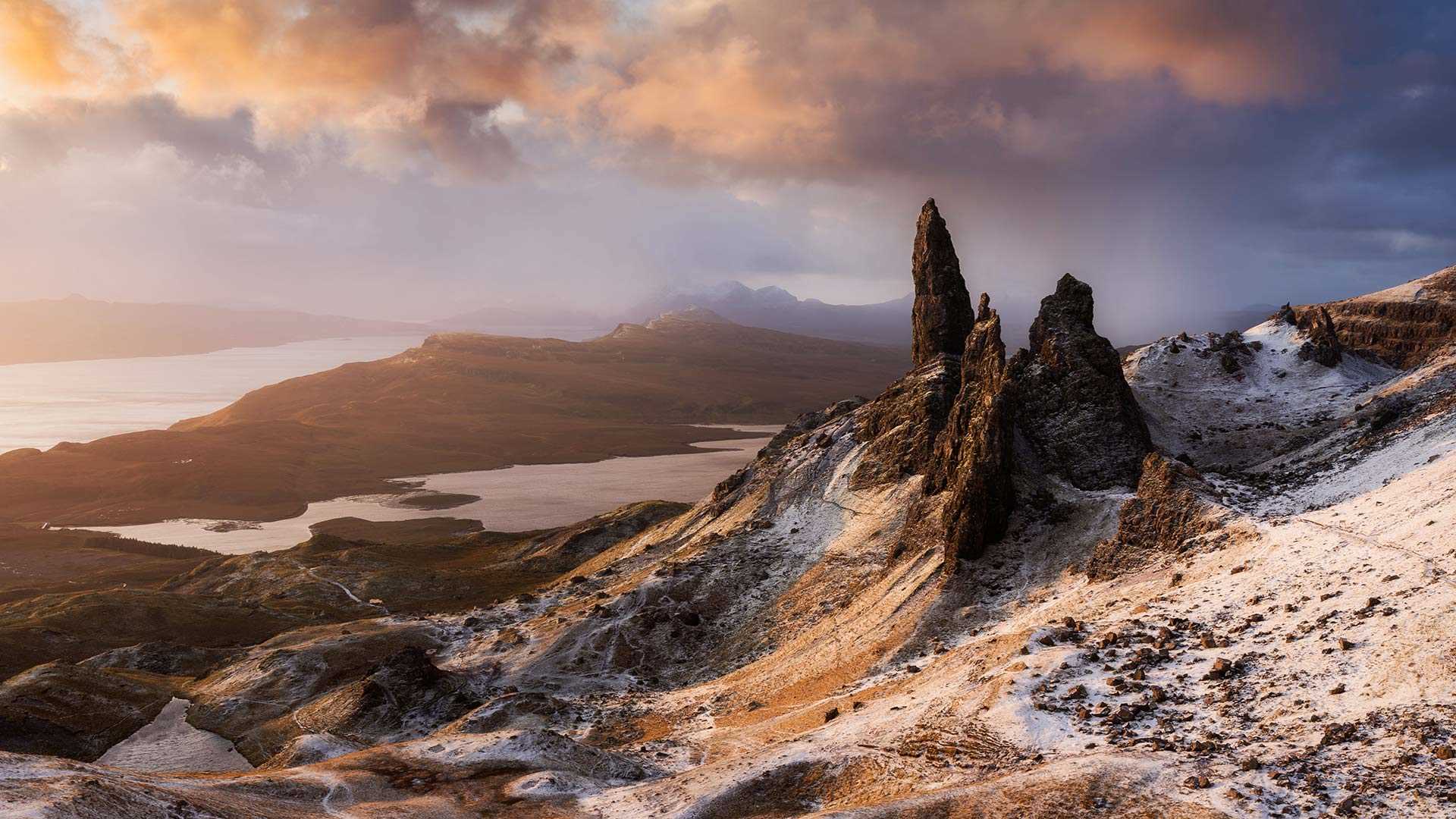
今天照片展示的是斯托尔山的老人峰,这座巨大的石峰耸立在英国最长的连续山体滑坡区之上。岛上有许多怪异而奇妙的岩石,都是由远古一次大滑坡形成的。
熔岩流、冰川和当地的气候共同造就了这幅奇幻的场景。著名的老人峰位于岛上“圣所”一域,在斯托尔山右侧,整体高约50米,与其他大型岩层相连。很久以前,熔岩流侵蚀岩层,而这块岩石逃过一劫,成了如今的老人峰。
远在几公里外,你便能享受斯托尔山的美景。但来到斯托尔山的人也将不虚此行,你可以在这里远眺拉赛岛和罗纳岛以及波特里城镇和库林丘陵的景色,还可以来一杯苏格兰纯麦威士忌。
马洛亚,瑞士 Maloja, Switzerland (© Roberto Moiola/Getty)
马洛亚,瑞士 Maloja, Switzerland (© Roberto Moiola/Getty)
雪花玻璃球一般的美景 A life-sized snow globe
瑞士马洛加
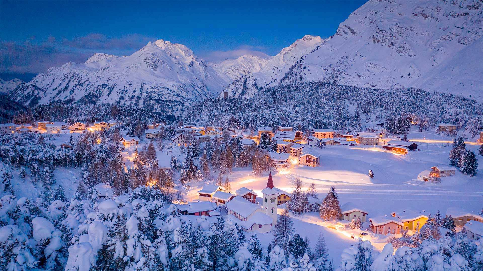
在拍摄瑞士马洛加的这张照片时,如画这个词是一个轻描淡写的词。这个位于格里森州或地区的高山村庄,无疑是全世界雪球的羡慕和鼓舞!这里距离意大利边境仅几英里,这里令人难以置信的完美冬季景色激发了几个世纪以来的画家和艺术家。马约拉也位于西尔斯湖的边缘,这使得该地区成为夏季和冬季的休闲胜地。这张照片的中心是马洛加的皇冠珠宝,即比利时伯爵在1880年代建造的教堂Chiesa Bianca。如今,曾经庄严的空间被用来举办展览和音乐会。
Maloja, Switzerland
The word picturesque is an understatement when taking in this image of Maloja, Switzerland. This alpine village in the canton, or district, of Grisons, is surely the envy and inspiration of snow globes the world over! Located just a few miles from the Italian border, the impossibly perfect winter scenes found here have inspired painters and artists for centuries. Majola is also located on the edge of Lake Sils, which makes this area a recreational destination in both summer and winter. At the center of this image is the crown jewel of Maloja, the Chiesa Bianca, a church built in the 1880s by a Belgian count. Today, the once solemn space is used to stage exhibitions and concerts.
格林达维克的蓝湖,冰岛 Blue Lagoon, Grindavík, Iceland (© Westend61/Getty Images)
格林达维克的蓝湖,冰岛 Blue Lagoon, Grindavík, Iceland (© Westend61/Getty Images)
治愈身心的“废水” The healing powers of wastewater
蓝湖水疗,格林达维克,冰岛
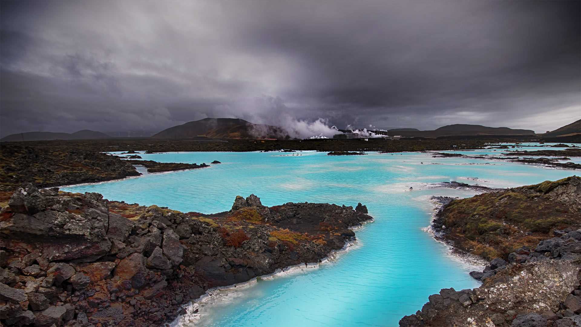
坦率地说,今天这张美丽图片的来源是附近地热发电厂的废水池。虽然这听起来并不诱人,但冰岛的蓝色泻湖是该国游客最多的景点之一。诀窍是不要陷入废水的“浪费”部分。这里的水是干净的,总是在100°F左右徘徊,富含大量的二氧化硅,这正是由于工厂的工艺,使其变蓝和变硫的原因。这些矿物质和少量藻类被认为是对皮肤和整体健康非常有益的补品。
Blue Lagoon spa, Grindavík, Iceland
Let's be frank here, the origin of today's beautiful picture is a pool of wastewater from a nearby geothermal plant. While that may not sound enticing, Iceland's Blue Lagoon is one of the country's most visited attractions. The trick is to not get stuck on the 'waste' part of wastewater. The water here is clean, always hovers around 100° F, and is enriched with tons of silica—which is what makes it blue—and sulfur thanks to the plant's processes. Those minerals, along with a little algae, are believed to combine into a highly beneficial tonic for skin and overall well-being.
贝弗利·韦斯特伍德,东约克郡,英格兰 Beverley Westwood Common, East Yorkshire, England (© Les Gibbon/Alamy)
贝弗利·韦斯特伍德,东约克郡,英格兰 Beverley Westwood Common, East Yorkshire, England (© Les Gibbon/Alamy)
阖家欢乐的一天 Giddy family fun
Beverley Westwood Common,东约克郡,英国
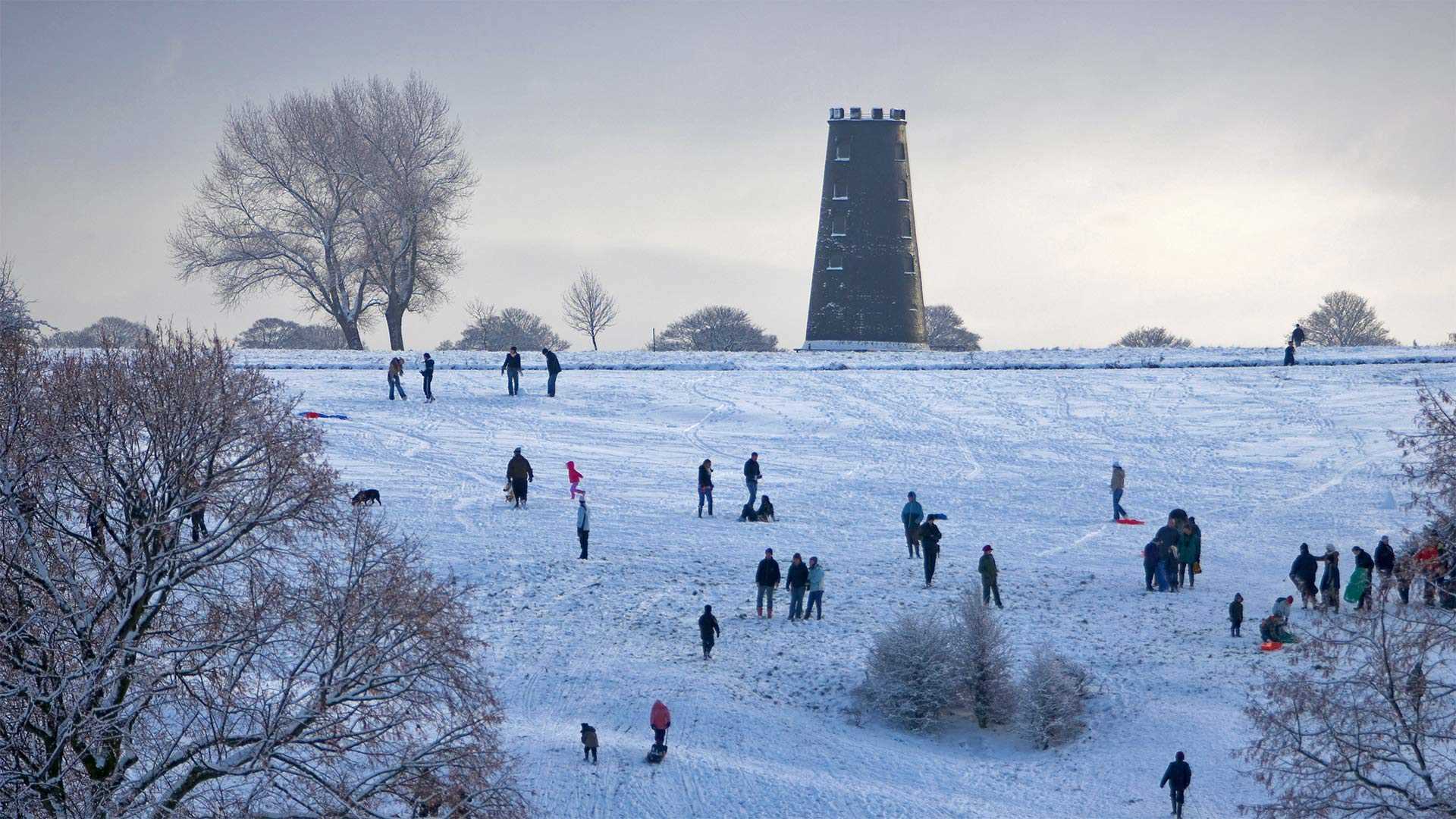
我们照片中的滑雪者正在享受英国的节礼日,他们在东约克郡黑磨坊附近的贝弗利韦斯特伍德公馆(Beverley Westwood Common)裹着行囊,冲下一座小山。传统上,节礼日是圣诞节兴奋过后放松的一天。名字后面是什么?有几种说法,但最被广泛接受的说法是,这个名字来源于圣诞节后第二天向穷人赠送“盒子”(礼物)。也许我们今天都应该效仿这个例子,吃圣诞剩饭,听萦绕的颂歌。我们怎样才能给那些不幸的人一个小小的圣诞节呢?
Beverley Westwood Common, East Yorkshire, England
The sledders in our photo are enjoying Boxing Day in England, bundled up and hurtling down a hill at Beverley Westwood Common near Black Mill in East Yorkshire. Traditionally, Boxing Day is a day off to relax after the excitement of Christmas. What's behind the name? There are a few theories, but the most widely accepted one is that the name derives from the giving of 'boxes' (of gifts) to the poor the day after Christmas. Perhaps we should all follow that example today, as we eat Christmas leftovers and listen to lingering carols. How can we give a little Christmas to those who are less fortunate?
阿玛咖港, 阿拉斯加美国 Amalga Harbor, Alaska (© Mark Kelley/Tandem Stills + Motion)
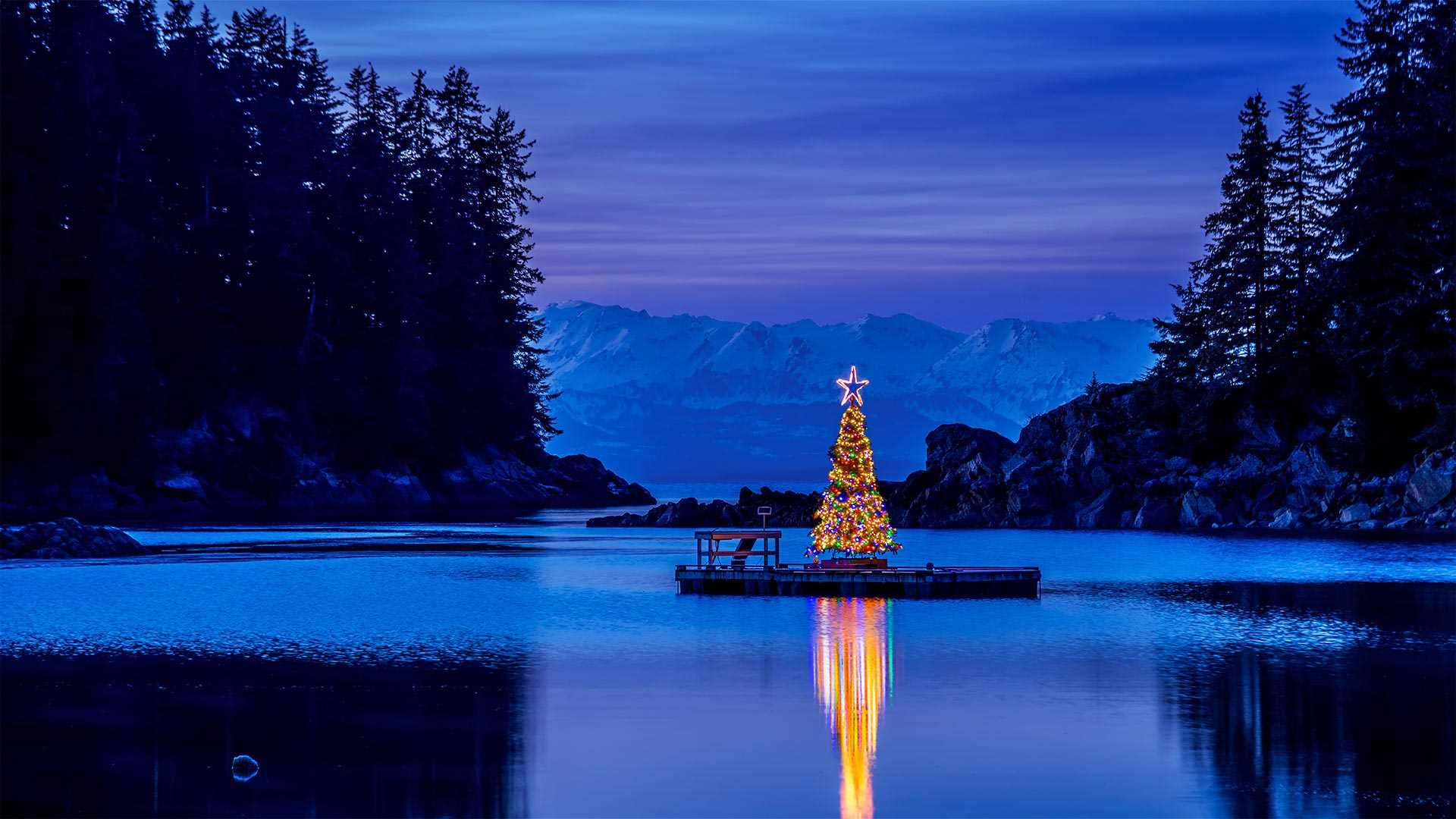
阿玛咖港, 阿拉斯加美国 Amalga Harbor, Alaska (© Mark Kelley/Tandem Stills + Motion)
一切都很平静 All is calm
阿拉斯加阿玛咖港的圣诞节
“最后的边境”上的这个与世隔绝的小海湾是你最不可能看到圣诞树从头到脚装饰着闪闪发光的地方。阿玛咖港位于朱诺(美国为数不多的沿海州首府之一)以北约15英里处,这表明公众表达圣诞快乐的方式很少有局限性,可能包括使用小型驳船。这张照片拍摄于附近的欧内斯特·格鲁宁州历史公园,该公园以阿拉斯加州前州长的名字命名。格鲁宁在1939年至1953年领导该地区,1959年阿拉斯加成为该州的第一批美国参议员之一。在他的政治生涯结束后,他和妻子住在一间小屋里,这间小屋被作为这一历史遗迹的一部分保存下来。
Christmas in Amalga Harbor, Alaska
This isolated cove on 'the Last Frontier' is the least likely place you'd expect to find a Christmas tree decorated from head to toe with lights aglow. Amalga Harbor lies about 15 miles north of Juneau (one of the few coastal state capitals in the US) and shows that the public expression of Christmas cheer knows few limitations–and may include use of a small barge. This photograph was taken from nearby Ernest Gruening State Historical Park, which was named for the former governor of the Alaska Territory. Gruening led the territory from 1939 to 1953 before becoming one of the state's first US senators when Alaska became a state in 1959. After his political career ended, he and his wife lived in a cabin that was preserved as part of this historic site.
黑梳山附近的惠斯勒小镇,加拿大不列颠哥伦比亚省 (© VisualCommunications/Getty Images)
南极洲的巴布亚企鹅 Gentoo penguins in Antarctica (© Nature Picture Library/Alamy)
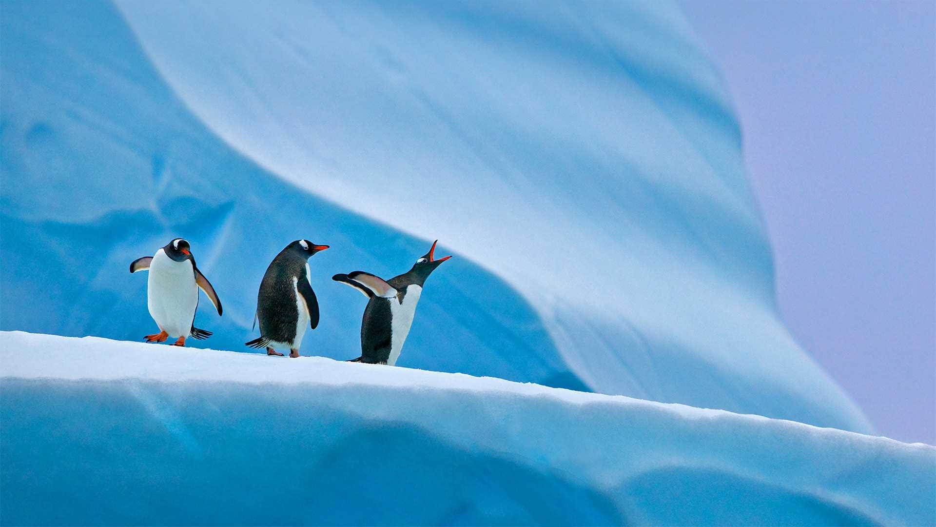
南极洲的巴布亚企鹅 Gentoo penguins in Antarctica (© Nature Picture Library/Alamy)
南极洲的巴布亚企鹅 'I've got a lot of problems with you penguins!'
南极洲的企鹅
对于外行来说,虚构节日Festivus的起源可以追溯到90年代热播剧《宋飞正传》的一集根据该剧编剧之一的真实家庭传统,Festivus在现实世界中展现了自己的生活,并为粉丝提供了一种有趣的、开玩笑的方式来庆祝节日,同时忽略了它的压力和商业性。
从今天的照片来看,南极洲的这些Gentoo企鹅似乎很了解Festivus,因为人们似乎正在参与节日的主要传统之一“哀怨之声”就Gentoo而言,他们有很多不满要发泄的情况并不罕见。无论是因为不忠而被逐出教会,还是因为邻居的巢石而嫉妒,Gentoo都可能是咸的。不过,也许这是意料之中的事,因为它们的饮食中含有大量的物质,以至于它们会从喙中漏出高浓度的盐水。
Gentoo penguins in Antarctica
For the uninitiated, the origins of the made-up holiday Festivus can be traced back to an episode of the hit '90s show, 'Seinfeld.' Based on the real family tradition of one of the show's writers, Festivus has taken on a life of its own in the real world and provides fans with a fun, tongue-in-cheek way to celebrate the holiday season while ignoring its pressures and commercialism.
And with today's photo, it appears these Gentoo penguins in Antarctica are well aware of Festivus, as one seems to be engaging in one of the holiday's main traditions—the 'Airing of Grievances.' And as far as Gentoos go, it's not uncommon for them to have plenty of grievances to air. Whether over excommunication for infidelity, or jealousy over their neighbor's nesting stones, Gentoos can be salty. Maybe that's to be expected, though, as their diets are so loaded with the stuff that they literally leak highly concentrated saline from their beaks.
老佛爷百货公司的圣诞树, 法国巴黎 Christmas tree of the Galeries Lafayette in Paris, France (© Geoffroy Van der Hasselt/AFP via Getty Images)
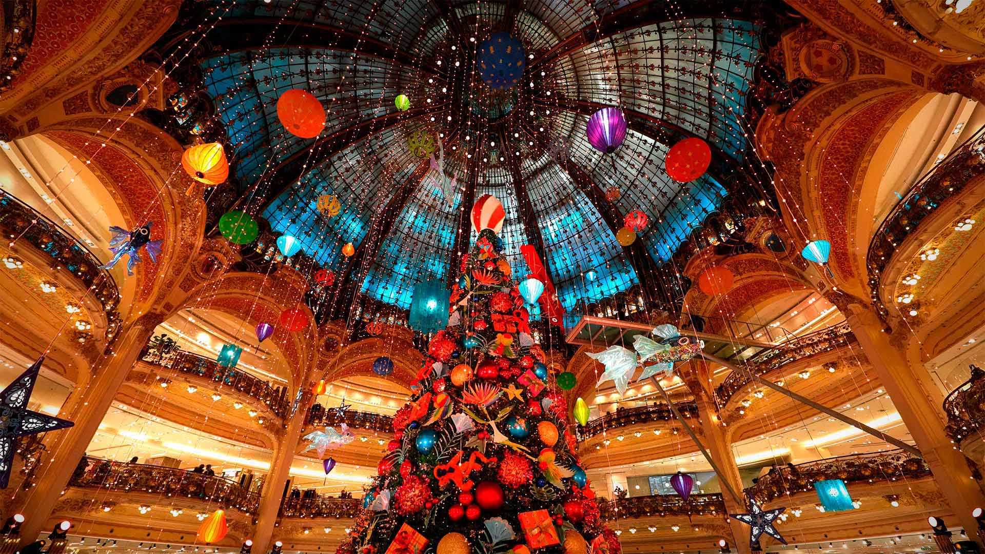
老佛爷百货公司的圣诞树, 法国巴黎 Christmas tree of the Galeries Lafayette in Paris, France (© Geoffroy Van der Hasselt/AFP via Getty Images)
光之城的光之季 Season of light in the City of Light
巴黎老佛爷百货公司
巴黎的老佛爷百货无疑是任何一个城市中最宏伟的商店之一。它不仅是一个购物的地方,也是光之城最受欢迎的目的地。在百货公司日渐衰落,整个零售业也在发生变化的时候,Galerie依然坚守着。它在金融危机、战争和现在的互联网中幸存了下来,仍然是巴黎生活中值得庆祝的一部分。像纽约的梅西百货或洛克菲勒中心一样,老佛爷百货是假日的代名词。每逢假日,商店的招牌彩色玻璃圆顶下都会装饰一棵巨大的杉树,这是巴黎人世代以来一直信奉的圣诞庆祝仪式。
Galeries Lafayette, Paris
Surely one of the grandest stores found in any city is the Galeries Lafayette in Paris. It's not just a place to shop but a destination as popular as any in the City of Light. At a time when department stores are fading and the entire retail industry is shifting, the Galerie holds fast. It has survived financial crises, wars, and now the internet, remaining a celebrated part of life in Paris. Like Macy's or Rockefeller Center in New York, the Galeries Lafayette is synonymous with the holidays. A giant fir is decorated every holiday season under the store's signature stained glass dome—a ritual of Christmas cheer that Parisians have embraced for generations.
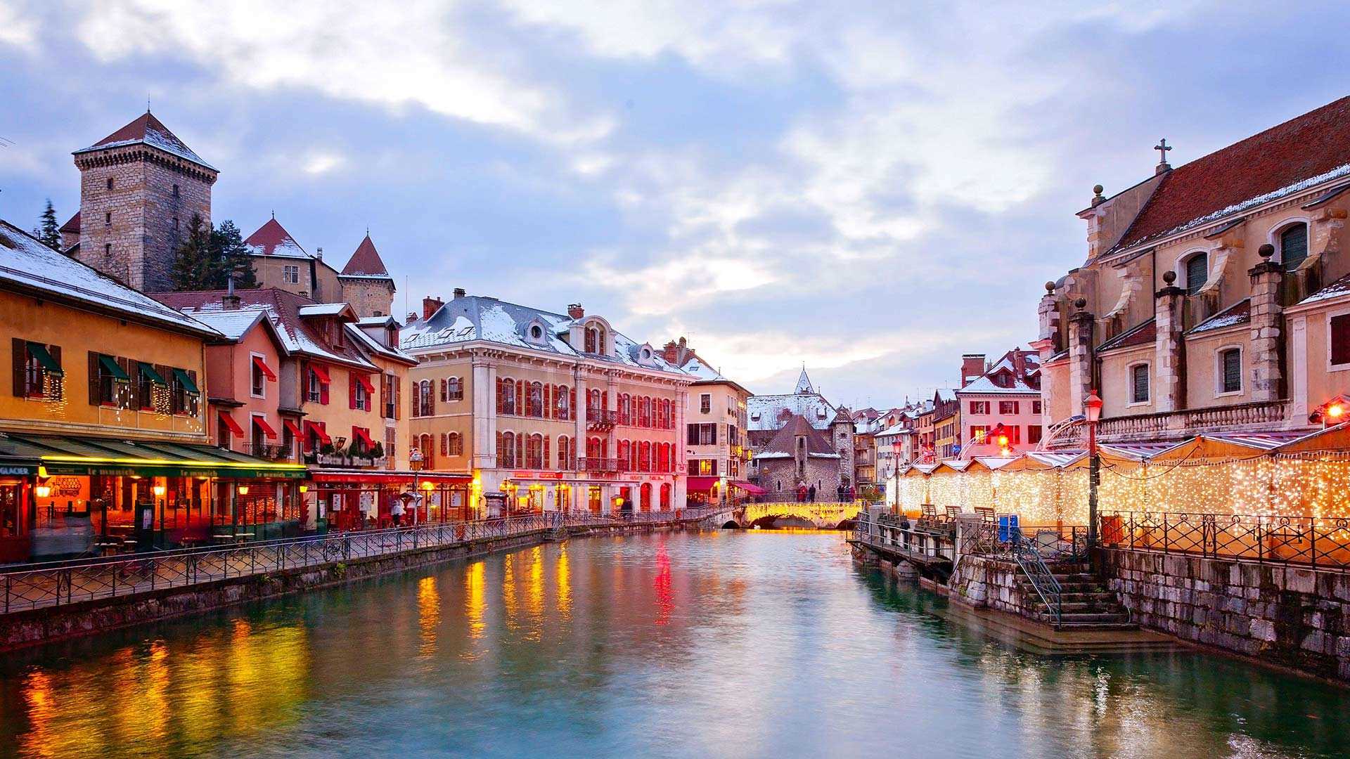
安纳西,法国上瓦萨省 (© Sabine Klein/Alamy)
多洛米蒂山脉安特莫亚湖上的日晕,意大利 Sun halo over Lake Antermoia in the Dolomite Mountains of Italy (© Walter Donega/Getty Images)
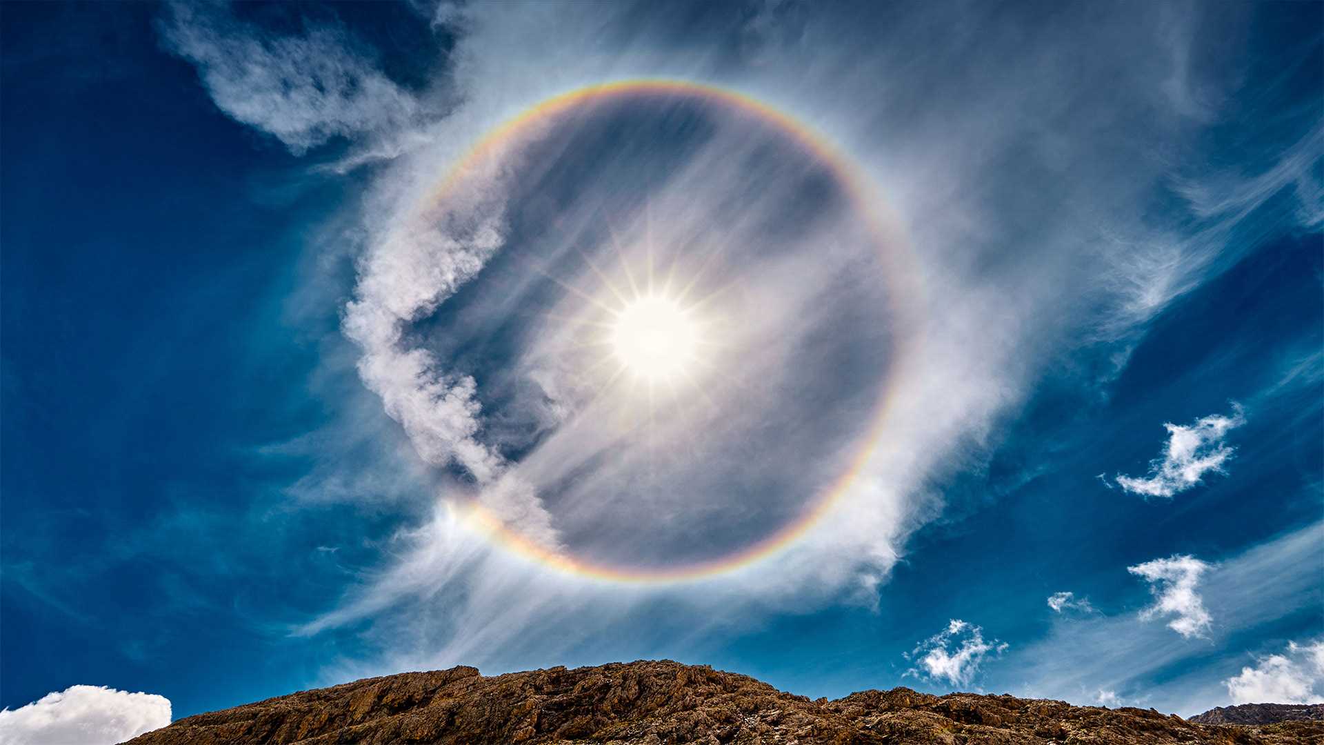
多洛米蒂山脉安特莫亚湖上的日晕,意大利 Sun halo over Lake Antermoia in the Dolomite Mountains of Italy (© Walter Donega/Getty Images)
环绕太阳的彩虹 Rainbow around the sun
意大利安特莫亚湖上空的太阳晕
从这里开始,日子只会变长!北半球今天标志着冬天的开始,但冬至也是一年中最短的一天。这里环绕太阳的彩虹,一个太阳光环,位于意大利北部多洛米特山脉的安特摩亚湖上方。当太阳或月亮的光线穿过悬浮在上层大气中的冰晶时,就会形成太阳晕。当太阳光照射到晶体上时,它们就充当了一个棱镜,将光分成光谱中的不同颜色,就像暴雨后彩虹出现的方式一样。
Sun halo over Lake Antermoia, Italy
The days only get longer from here! The Northern Hemisphere marks the beginning of winter today, but the winter solstice is also the shortest day of the year. The rainbow that encircles the sun here, a sun halo, is above Lake Antermoia, in the Dolomite Mountains of northern Italy. Sun halos form when sun or moon light shines through ice crystals suspended in the upper atmosphere. When the light of the sun hits the crystals they serve as a prism, separating the light into individual colors of the spectrum, the same way rainbows occur after a rain shower.