黄昏时的鹿谷,帕克城,犹他州,美国 Deer Valley at dusk, Park City, Utah (© Adventure_Photo/Getty Images)
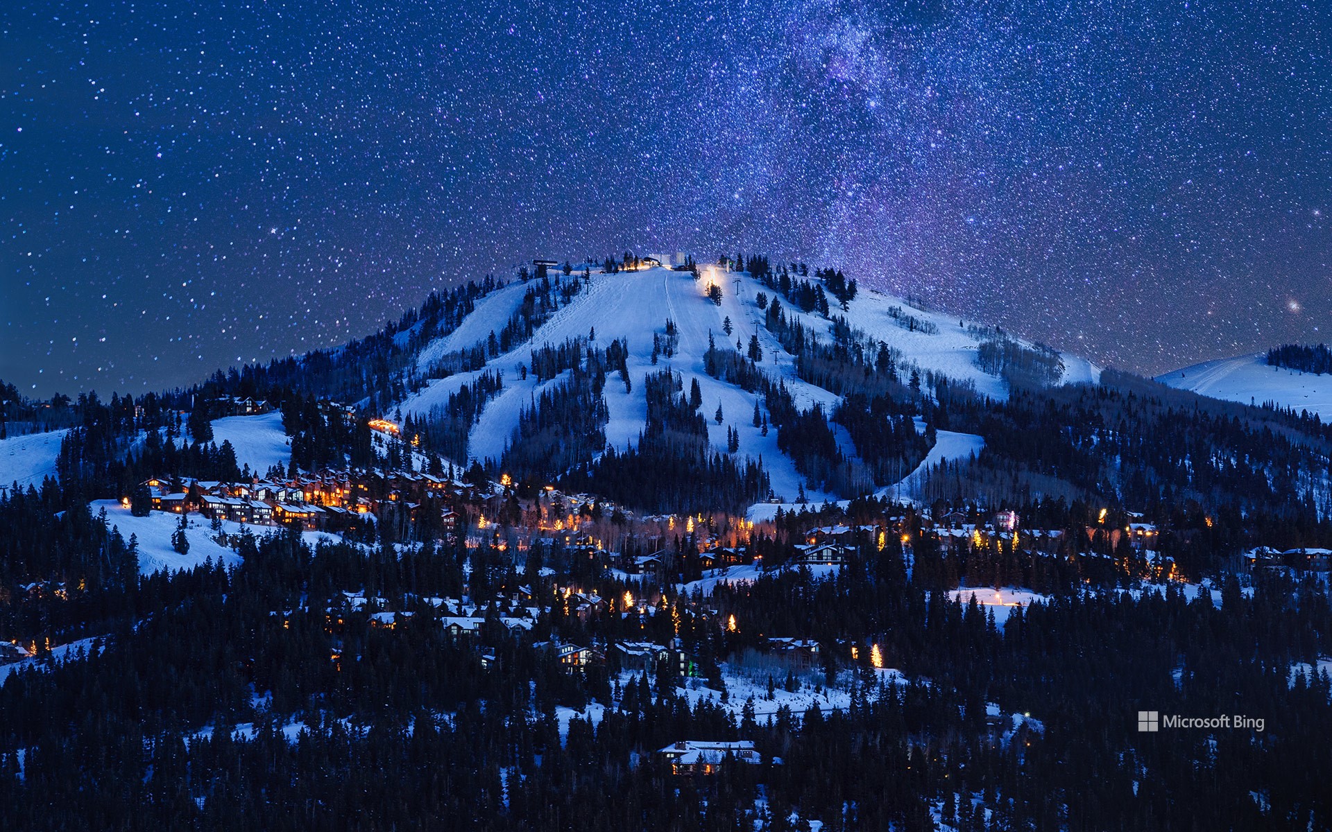
黄昏时的鹿谷,帕克城,犹他州,美国 Deer Valley at dusk, Park City, Utah (© Adventure_Photo/Getty Images)
电影、山脉和魔法 Movies, mountains, and magic
鹿谷,帕克城,犹他州,美国
今天,圣丹斯电影节拉开帷幕,以犹他州的群山为背景,庆祝电影的魅力。电影节的中心是帕克城,它是圣丹斯活力四射的主办城市之一,活动在犹他州的多个地点举行。每年一月,这个宁静的旅游胜地都会变成一个热闹的创意中心,吸引来自世界各地的电影制作人和电影爱好者。除了银幕,帕克城也值得一游。这里拥有迷人的风景、鹿谷和帕克城山等顶级滑雪胜地,以及无尽的户外探险活动,从徒步旅行、骑自行车到泡温泉,应有尽有。无论你是来看电影还是寻求刺激,帕克城圣丹斯电影节都将为你带来难忘的体验。
Sundance Film Festival
Today, the Sundance Film Festival kicks off, celebrating the magic of movies against the backdrop of Utah's mountains. As a launchpad for groundbreaking films and emerging talent, Sundance has come a long way since its humble beginnings in 1978. Now one of the film industry's most influential events, it has introduced the world to talents like Quentin Tarantino and Steven Soderbergh, whose early works premiered here before shaping their iconic careers. With competitive sections for dramatic and documentary movies, from features to shorts, the festival offers an inspiring array of storytelling.
At its heart is Park City, pictured here, one of Sundance's vibrant host cities—the event takes place across several Utah locations. Every January, this quaint destination transforms into a buzzing hub of creativity, drawing filmmakers and cinephiles from across the globe. Beyond the silver screen, Park City is worth exploring. It boasts stunning landscapes, top-tier ski resorts like Deer Valley and Park City Mountain, and endless outdoor adventures, from hiking and biking to soaking in nearby hot springs. Whether you're here for the films or the thrills, Sundance in Park City promises an unforgettable experience.
代尔修道院,佩特拉,约旦 Ad-Deir, Petra, Jordan (© Punnawit Suwuttananun/Getty Images)
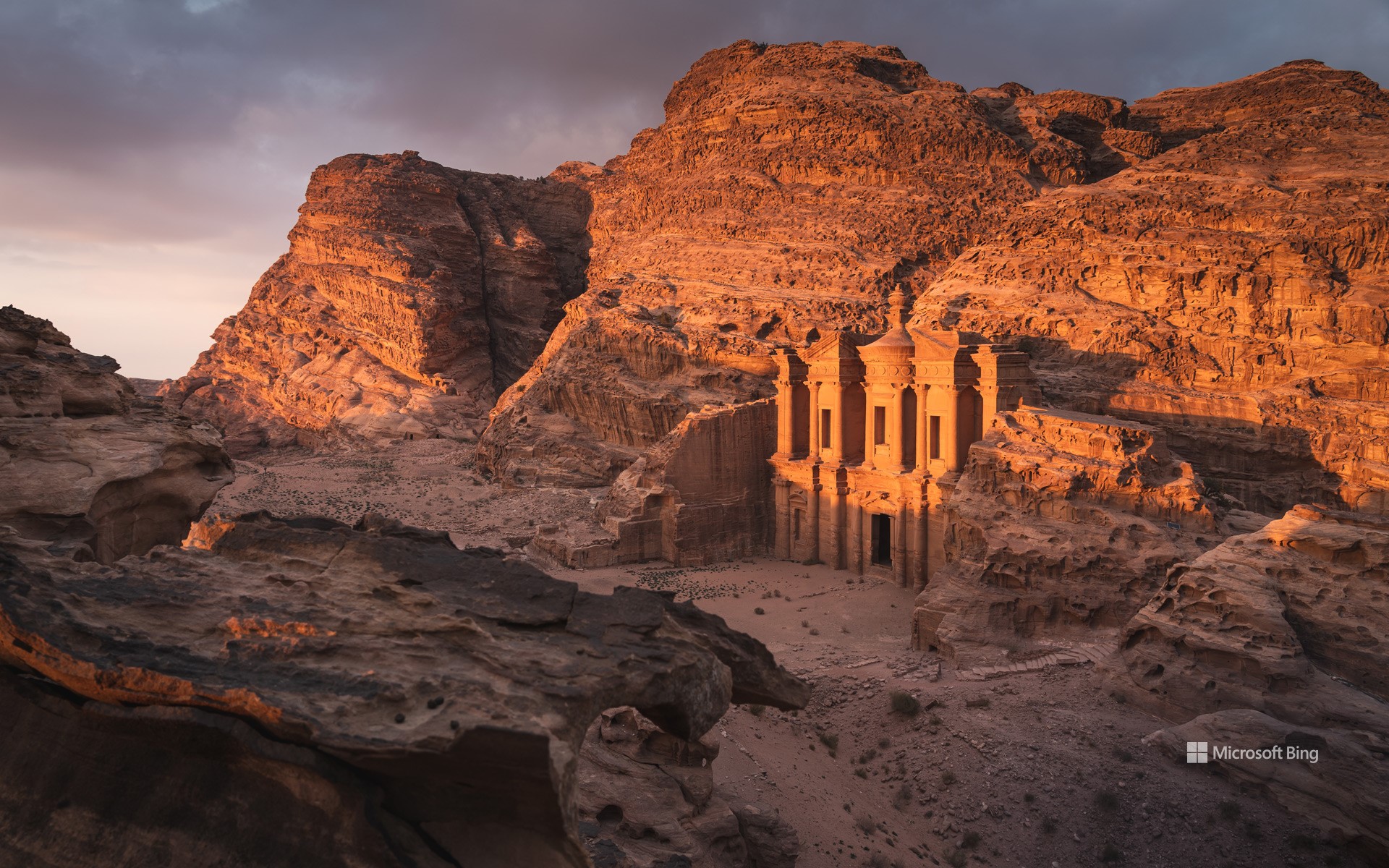
代尔修道院,佩特拉,约旦 Ad-Deir, Petra, Jordan (© Punnawit Suwuttananun/Getty Images)
在失落之城发现美 Finding beauty in the Lost City
代尔修道院,佩特拉,约旦
佩特拉及其皇冠上的明珠——代尔修道院,雕凿在玫瑰色的悬崖峭壁上,让人仿佛置身于电影《印第安纳琼斯》的探险场景中。这座古城坐落在约旦干旱沙漠地貌的中心,曾在公元前2世纪作为纳巴泰王国的首都而繁荣一时。它还是香料贸易的枢纽,连接着中国、埃及、希腊和印度等遥远地区。
今天图片中的代尔修道院可追溯到公元1世纪。其设计融合了希腊风格和美索不达米亚风格。尽管对该建筑的确切用途还存在争议,但普遍认为它在拜占庭时期被用作教堂。这座建筑高近150英尺,宽160英尺,巨大的外墙直接雕刻在砂岩悬崖上,展示了纳巴泰人巧夺天工的工艺和建筑艺术。要到达这座地标性建筑,需徒步攀登800级陡峭的石阶,在岩石地形中蜿蜒前行。尽管攀登的过程有些艰辛,但到达山顶后,你可以俯瞰佩特拉崎岖山谷的全貌,一切努力在此刻都会非常值得。
Ad-Deir, Petra, Jordan
Carved into rose-red cliffs, Petra and its crown jewel, Ad-Deir (The Monastery) feel like stepping into a real-life Indiana Jones adventure. Tucked in the heart of Jordan's arid desert landscapes, this ancient city once thrived as the capital of the Nabataean Kingdom in the 2nd century BCE. It was also a hub of the spice trade, connecting distant regions like China, Egypt, Greece, and India. The city was abandoned for around 500 years before being rediscovered in 1812, earning it the Lost City moniker.
Ad-Deir, seen in today's image, dates to the 1st century CE. Its design is characterized by a combination of Hellenistic and Mesopotamian influences. Although the exact purpose of the structure is debated, it's believed to have been used as a church during the Byzantine period. Standing nearly 150 feet tall and 160 feet wide, its massive facade is carved directly into the sandstone cliffs, showcasing the Nabataeans' ingenious craftsmanship and architecture. The journey to this landmark involves a steep hike up 800 stone steps, winding through rocky terrain. At the top, you're rewarded with panoramic views of the rugged Petra valley that make the climb more than worth it.
俯瞰那不勒斯湾和维苏威火山,意大利 Looking over the Gulf of Naples towards Mount Vesuvius, Italy (© ezypix/Getty Images)

俯瞰那不勒斯湾和维苏威火山,意大利 Looking over the Gulf of Naples towards Mount Vesuvius, Italy (© ezypix/Getty Images)
那不勒斯湾和维苏威火山,意大利
那不勒斯湾(意大利语:Golfo di Napoli)是位于意大利西南海岸(大都市区那不勒斯,坎帕尼亚地区)的一个海湾,宽约15公里,向西通往地中海。那不勒斯湾因风景优美而闻名,是著名的旅游区,沿岸有陡峭的火山峰,包括维苏威火山等活火山以及庞贝古城、赫库兰尼姆古城遗址。海湾入口处有卡普里岛、伊斯基亚岛和普罗奇达岛等风景名胜。据说罗马皇帝卡里古拉在海湾上建造了一座船桥,他身穿亚历山大大帝的盔甲,乘坐战车横跨海湾。
海王星石窟,撒丁岛, 意大利 Neptune's Grotto, Sardinia, Italy (© Carlo Murenu/Getty Images)
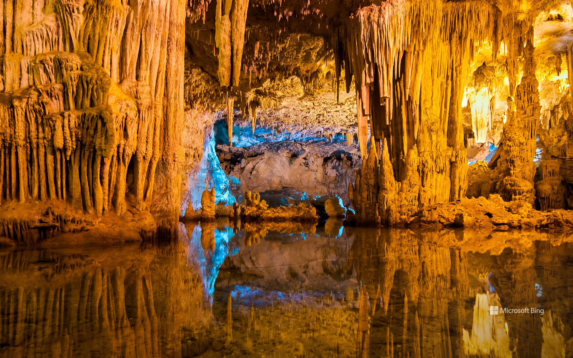
海王星石窟,撒丁岛, 意大利 Neptune's Grotto, Sardinia, Italy (© Carlo Murenu/Getty Images)
一座适合神居住的石窟 A grotto fit for a god
海王星石窟,撒丁岛,意大利
沿着654级台阶俯瞰撒丁岛海面,令人惊叹的景象尽收眼底。海王星石窟是一座距海平面仅约3英尺的钟乳石洞穴。这座洞穴由当地渔民在18世纪首次发现,以罗马海神尼普顿命名。整个洞穴系统全长约4023米,游客可进入的区域仅约304.8米。洞内有迷宫般的小径,灯光照亮蜿蜒穿过钟乳石与石笋的路径,最终通向一个约119米长的咸水湖。
海王星石窟位于地中海第二大岛撒丁岛西北海岸的阿尔盖罗镇附近。撒丁岛的历史可追溯至1万年前,努拉吉是最重要的古代文明,努拉吉人在公元前1800年至公元2世纪期间生活于此。当时,村庄围绕着一种称为努拉吉塔的圆形塔楼要塞建造。如今,岛上保存着约7,000座努拉吉塔,已成为撒丁岛的象征。除了丰富的历史遗迹,撒丁岛还以其原始的海滩、崎岖的山脉和美味佳肴而闻名于世。
Neptune's Grotto, Sardinia, Italy
Down 654 steps, perched perilously over the sea in Sardinia, Italy, you'll find a surprise waiting for you. Neptune's Grotto is a stunning stalactite cave that sits just over 3 feet above sea level. First discovered by local fishermen in the 18th century, the grotto was named after the Roman god of the sea. The entire cave complex stretches on for around 2.5 miles, although visitors can only access about 1,000 feet of the total. Inside, there's a labyrinth of lit pathways winding past stalactite and stalagmite formations, leading to a 390-foot-long saltwater lake.
Neptune's Grotto is near the town of Alghero on the northwest coast of Sardinia, the second-largest island in the Mediterranean. It has been inhabited for at least 10,000 years, but its most important ancient civilization, the Nuragic peoples, lived there from around 1800 BCE until the 2nd century CE. At this time, villages were built around nuraghes, a kind of round tower fortress. Today, there are still around 7,000 of these nuraghes across the island, and they have become a symbol of Sardinia. Beyond its history, Sardinia is known for its beaches, mountains, and cuisine.
白沙国家公园的日落,新墨西哥州,美国 Sunset at White Sands National Park, New Mexico (© Image Professionals GmbH/Alamy Stock Photo)
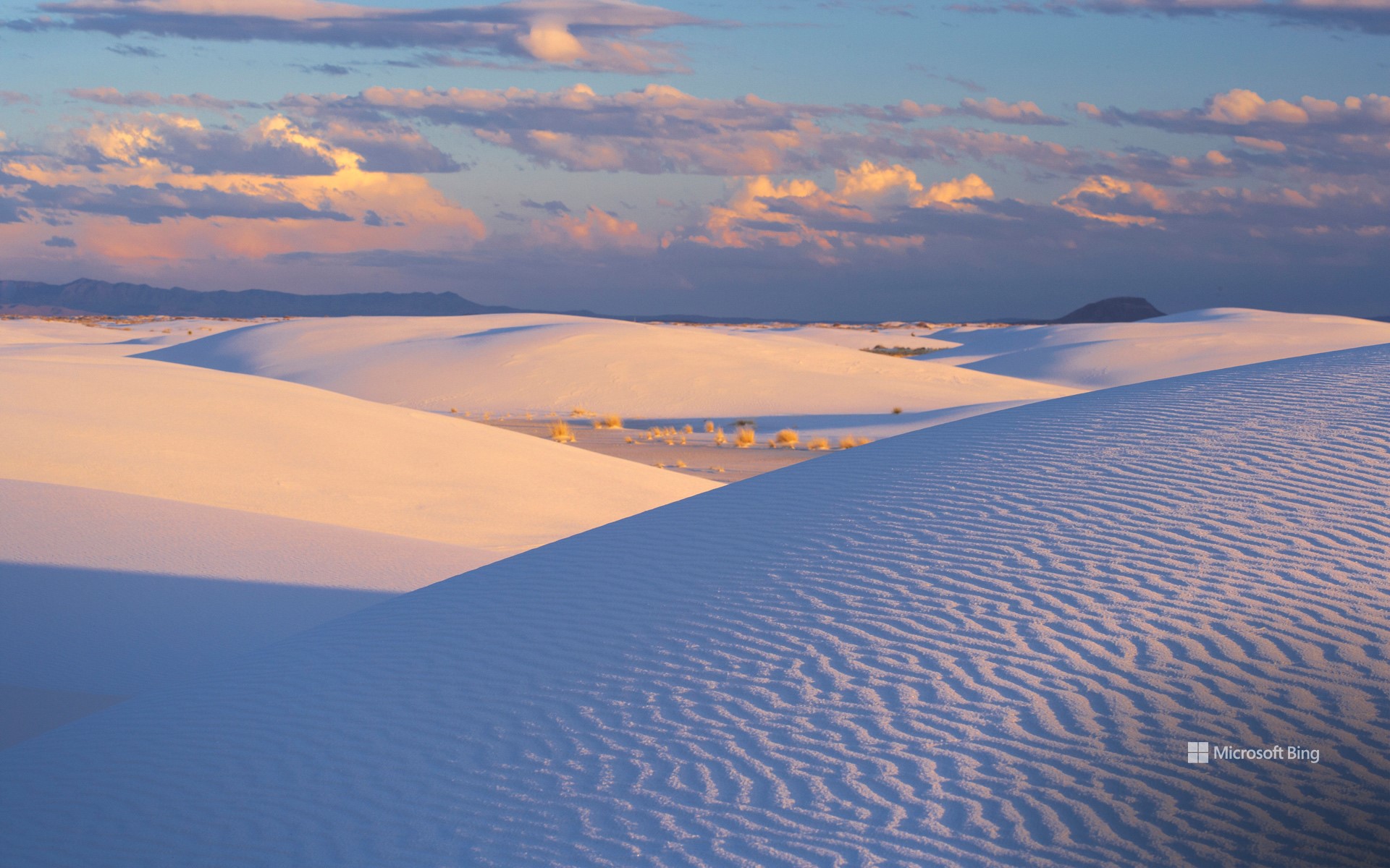
白沙国家公园的日落,新墨西哥州,美国 Sunset at White Sands National Park, New Mexico (© Image Professionals GmbH/Alamy Stock Photo)
1,001座白色沙丘 1,001 Mexican dunes
白沙国家公园的沙丘,新墨西哥州
今日图片展示了新墨西哥州白沙国家公园最令人叹为观止的自然奇观,一片闪耀梦幻光芒的白色沙丘,这里有地球上规模最大的石膏沙丘。这片广袤的沙漠占地超过145,000英亩,沙丘高度可达60英尺,展现出其他地方难以见到的独特景观。这座公园不仅是自然奇观,更是历史瑰宝,这里发现了距今约23,000年的化石化人类脚印,被认为是北美最古老的人类遗迹之一。
今天是白沙国家公园于1933年由总统赫伯特·胡佛设立为保护区的周年纪念日。还有什么比沉浸在白沙美景中更适合庆祝的方式呢?在这里可以徒步旅行、沙丘滑沙,或者沿风景优美的公路驾车欣赏美景。无论是其丰富的历史,还是叹为观止的日落,白沙国家公园都是一个令人心驰神往的旅行目的地。
Dunes at White Sands National Park, New Mexico
Today's image features the dazzling beauty of White Sands National Park, New Mexico—a surreal expanse of glistening white gypsum dunes, the largest of its kind on Earth. Spanning more than 145,000 acres, these ever-shifting dunes rise up to 60 feet tall, creating a landscape not seen in many places. This park isn't only a natural wonder but a historical treasure, with fossilized human footprints dating back as far as 23,000 years, some of the oldest in North America.
Today marks the anniversary of White Sands being established as a protected site in 1933 by President Herbert Hoover. What better way to celebrate than by immersing yourself in its beauty? Enjoy activities like hiking, sledding down the dunes, or taking a scenic drive. Whether for its rich history or jaw-dropping sunsets, White Sands National Park is a wish-list destination that will leave you in awe.
尖峰国家公园的高峰步道,圣贝尼托县,加利福尼亚州,美国 High Peaks Trail at Pinnacles National Park, San Benito County, California (© yhelfman/Getty Images)
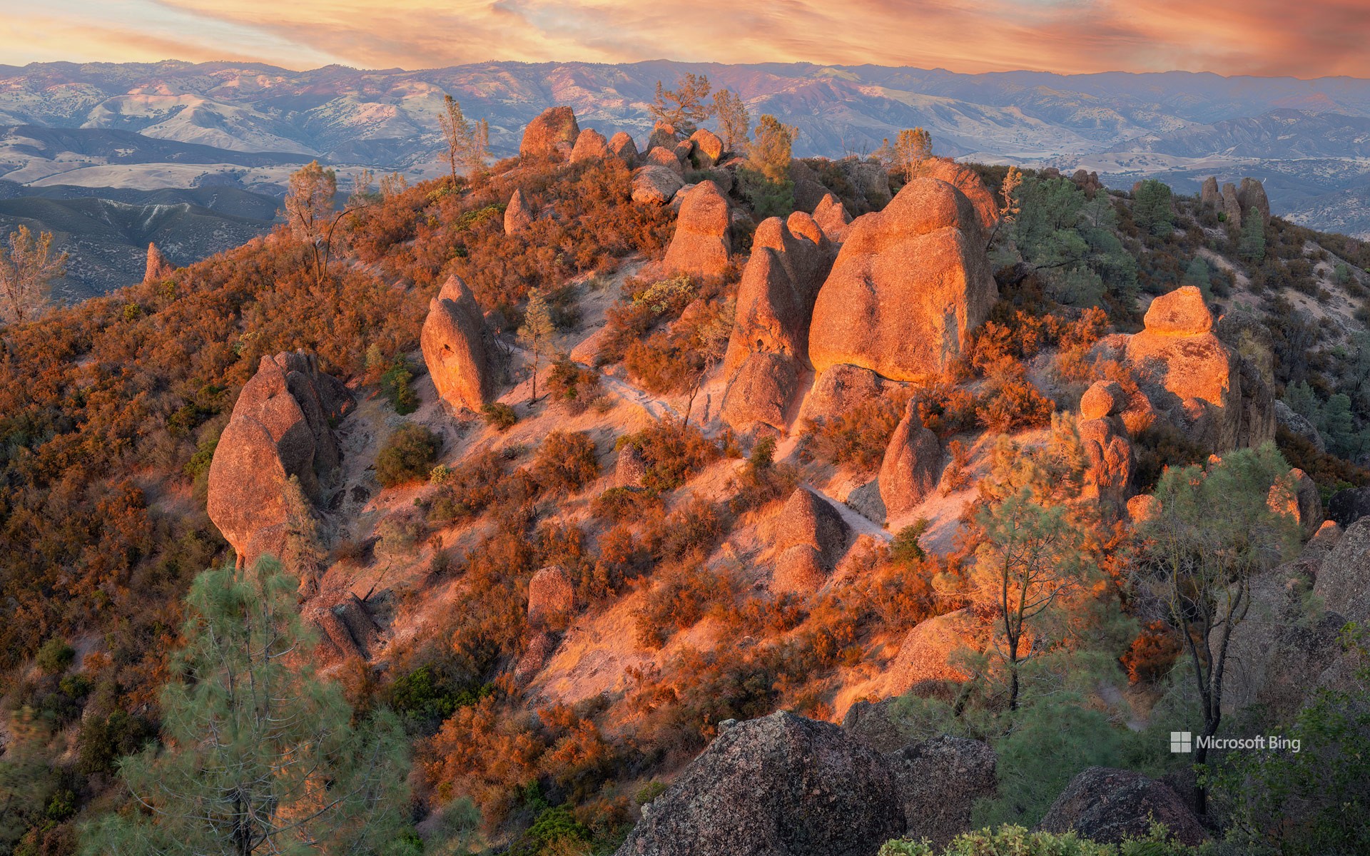
尖峰国家公园的高峰步道,圣贝尼托县,加利福尼亚州,美国 High Peaks Trail at Pinnacles National Park, San Benito County, California (© yhelfman/Getty Images)
诞生于火,历久弥坚 A monumental milestone
加利福尼亚州尖峰国家公园成立纪念日
欢迎来到加州中部的尖峰国家公园,布满了锯齿状山峰、石塔、巨石和奇特的洞穴。1908年,当时西奥多·罗斯福总统将该地区指定为国家纪念地。随后在2013年,尖峰正式升级为国家公园。在庆祝其成立周年之际,让我们花点时间欣赏这个地方。2300万年前的一次火山喷发,造就了公园独特的地貌。这段炽热的历史创造了高耸的岩柱、峭壁和塌落巨石形成的堆积洞穴。经过数百万年的板块构造运动,这片土地向北推移,使公园远离了最初的火山发源地。真是一段漫长而奇妙的旅程!
公园内有各种徒步路线,既有轻松的步道,也有极具挑战的攀爬路径。例如,今日图片中展示的高峰步道,以陡峭的攀爬和狭窄通道著称,极为考验体力;而熊谷水库则提供了更悠闲的漫步体验。此外,尖峰国家公园也是多种野生动物的家园,包括山猫、野兔、黑尾鹿,以及啄木鸟和蝙蝠等鸟类,吸引着众多野生动物爱好者。公园最珍贵的宝藏之一是曾濒临灭绝的加利福尼亚神鹰。通过成功的保护计划,这些雄伟的鸟类被重新引入,成为尖峰国家公园引以为傲的成就。
Anniversary of Pinnacles National Park, California
Jagged pinnacles and spires, monoliths, and unusual caves—welcome to Pinnacles National Park in central California. President Theodore Roosevelt designated the area as a national monument in 1908, and Pinnacles would earn its status as a national park in 2013. As we celebrate the park's anniversary today, let's take a moment to appreciate this landscape. Pinnacles owes its formations to an ancient volcanic eruption that occurred 23 million years ago. The fiery beginnings made towering spires, cliffs, and talus caves, which are created by falling boulders wedged into narrow canyons. Over millennia, tectonic forces shifted the landmass northward, leaving the park far from its volcanic birthplace. Talk about a journey!
Pinnacles offers a variety of trails, from easy walks to challenging climbs. The High Peaks Trail, featured in today's image, tests your stamina with steep climbs and narrow passages, while Bear Gulch Reservoir provides a more relaxed stroll. Pinnacles is home to a range of wildlife including bobcats, jackrabbits, and black-tailed deer, and bird species like woodpeckers and bats, making it attractive for wildlife enthusiasts. Among the park's many treasures are once-endangered California condors, which were reintroduced here in a successful conservation effort.
魔鬼角,圣皮埃尔,留尼汪岛 (© MONTICO Lionel/Alamy)
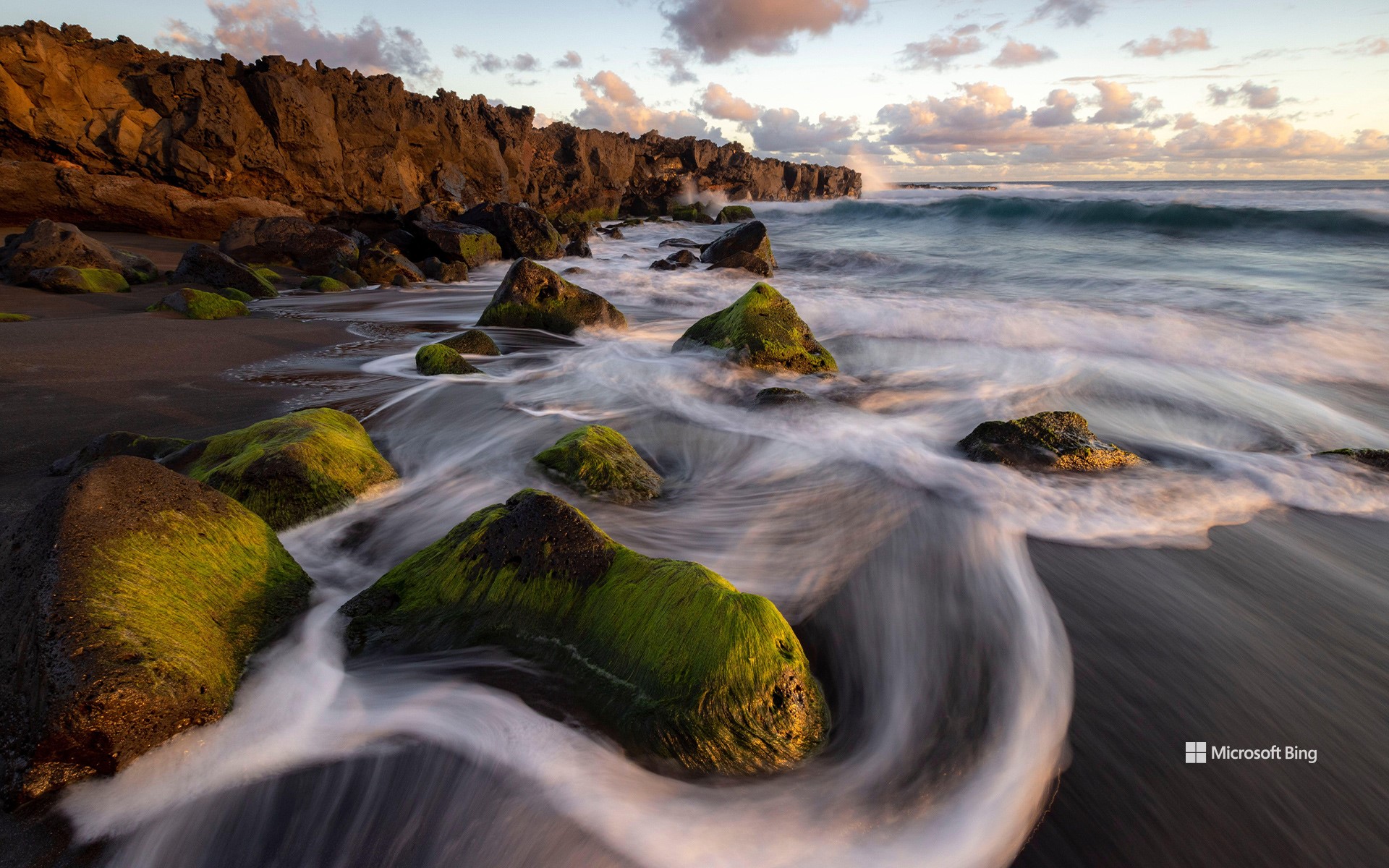
魔鬼角,圣皮埃尔,留尼汪岛 (© MONTICO Lionel/Alamy)
魔鬼与自然的气息
留尼汪岛,魔鬼角
魔鬼角(Pointe du Diable)位于留尼汪岛,这里展现了自然力量与神秘气息的奇妙交汇。魔鬼角由约20万年前内日峰的熔岩流形成,这片玄武岩半岛壮丽地伸入印度洋。
魔鬼角的一侧曾是冲浪者的天堂,如今因鲨鱼袭击事件而让人敬畏,但这里依然回荡着人类与海洋和谐共处的传说。另一侧是卵石滩,海浪在这里不断雕刻着地貌。海风裹挟着咸腥的海水,波涛拍击悬崖的回响萦绕耳边,让人深刻感受到自然的残酷力量。
对于渔民来说,这里是一个盛产岩鱼的避风港。对于徒步旅行者,沿着海岸小径探索,可欣赏到令人叹为观止的全景景观。魔鬼角迷人与危险并存,是留尼汪岛地质与人类历史的生动见证。在此反思与自然的关系,心怀敬畏与感激。
萨阿拉·德拉谢拉村,加的斯省,西班牙 Village of Zahara de la Sierra, Cádiz province, Spain (© SEN LI/Getty Images)
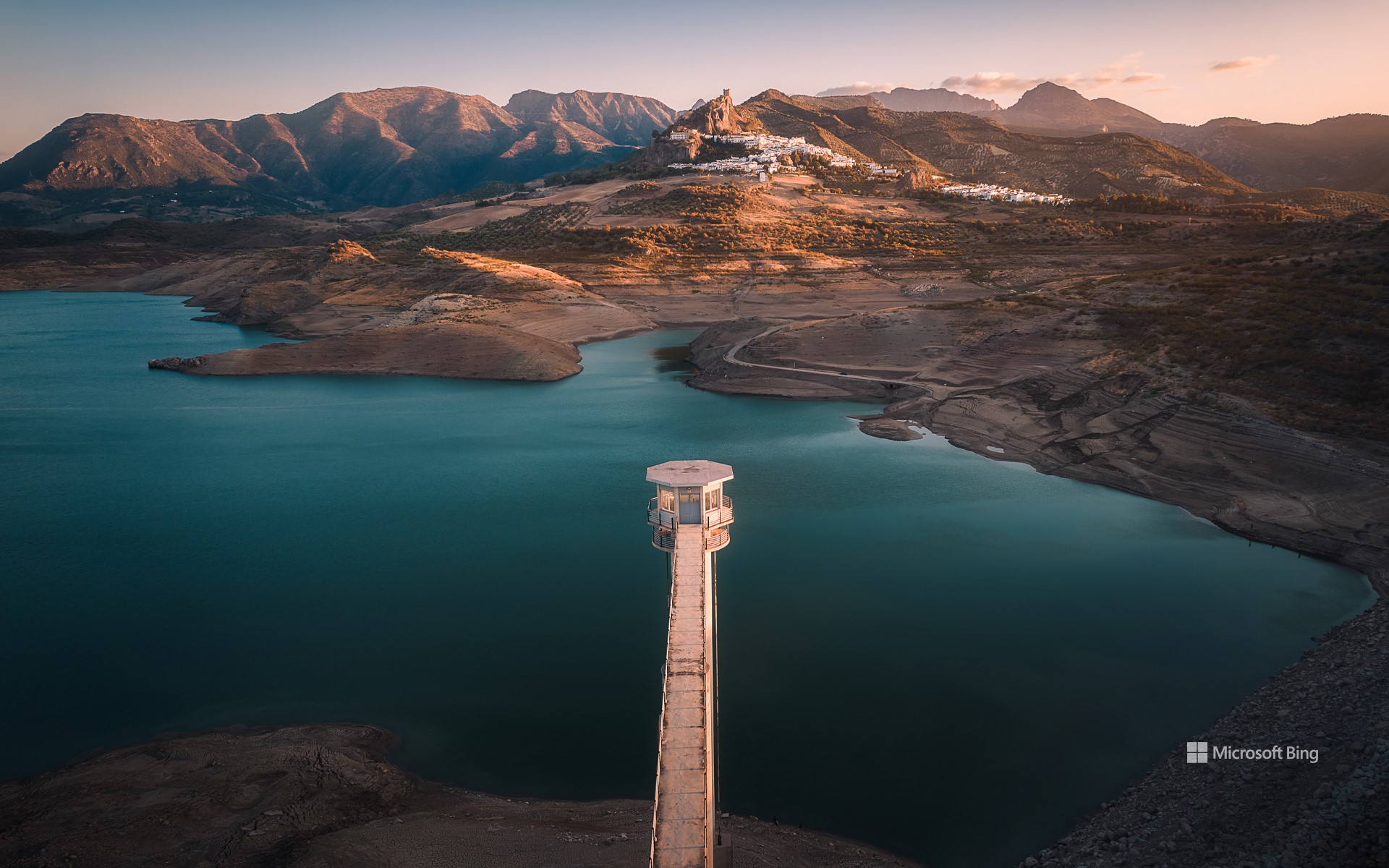
萨阿拉·德拉谢拉村,加的斯省,西班牙 Village of Zahara de la Sierra, Cádiz province, Spain (© SEN LI/Getty Images)
宁静之地 Calmness overload
萨阿拉·德拉谢拉村,加的斯省,西班牙
萨哈拉·德拉谢拉位于西班牙加的斯的群山之上,是伊比利亚半岛南部历史与自然完美结合的白色小镇。村庄坐落在岩石山顶,从今日图片中可以看到,它俯瞰着碧蓝的萨哈拉-埃尔加斯托尔水库和郁郁葱葱的格拉萨莱马自然公园。该公园自1977年起被列为联合国教科文组织生物圈保护区。村内的摩尔人城堡遗址和15世纪塔楼,见证了其作为中世纪要塞的辉煌历史。漫步在鲜花簇拥的狭窄街道,参观风景如画的圣玛丽亚德拉梅萨教堂,或放松身心,尽享壮丽景色。萨哈拉·德拉谢拉还是探险的门户,徒步、骑行和皮划艇等活动只是小镇丰富体验的一部分。
许多人认为萨哈拉·德拉谢拉的名字来自阿拉伯语“azahar”,意为柑橘花。然而,研究表明,这一名称实际上源自“sahra”,意为荒野或贫瘠的土地,反映了小镇所在的岩石山地特征。作为安达卢西亚著名的“白色城镇”,萨哈拉·德拉谢拉定会让你在西班牙最美的角落之一收获难忘的体验。
Village of Zahara de la Sierra, Cadiz, Spain
Zahara de la Sierra, a stunning whitewashed village in the hills of Cádiz province in Spain, offers a blend of history and nature in the south of the Iberian Peninsula. Perched on a rocky hilltop, the village seen in today's image overlooks the Zahara-El Gastor Reservoir and the Sierra de Grazalema Natural Park, a UNESCO Biosphere Reserve since 1977. Its Moorish castle ruins and 15th-century tower reflect its history as a medieval fortress. Stroll through streets lined with flower-filled balconies, visit the church of Santa María de la Mesa, or simply relax and take in the views. Zahara is also a gateway to adventure—activities like hiking, cycling, and kayaking are only a little of what the village has to offer.
The name 'Zahara de la Sierra' was once thought to have come from 'azahar,' the Arabic word for 'citrus blossom.' However, studies suggest it comes from 'sahra,' which means 'wild' or 'barren land,' reflecting the rugged hill where the village is located. As part of Andalusia's Route of the White Villages, Zahara de la Sierra promises unforgettable experiences in a beautiful corner of Spain.
小屋和特尔莫尔灯塔,兰德温岛,威尔士,英国 Cottage with Tŵr Mawr Lighthouse in the background, Ynys Llanddwyn, Wales (© Westend61 on Offset/Shutterstock)
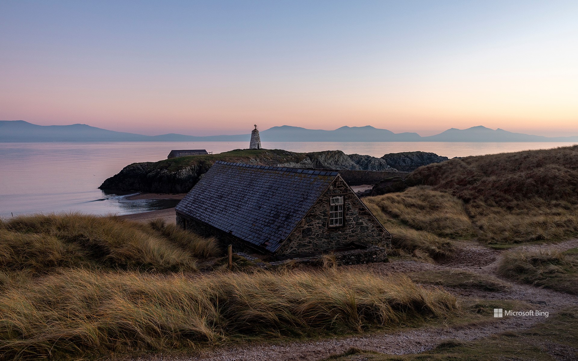
小屋和特尔莫尔灯塔,兰德温岛,威尔士,英国 Cottage with Tŵr Mawr Lighthouse in the background, Ynys Llanddwyn, Wales (© Westend61 on Offset/Shutterstock)
“威尔士”祝你新年快乐! 'Welsh' you a Happy Hen Galan!
威尔士新年快乐!
谁说新年一定要在1月1日?在威尔士,1月13日,人们会“时钟倒转”庆祝盖兰节,也就是“旧新年”。 在这一传统中,“Calennig”(意为“新年礼物”)起着核心作用,将庆典与儒略历时代的风俗相连接。尽管1582年世界大部分地区改用格里高利历,但威尔士的一些地区依然坚持旧传统。在传统上,这一天会有孩子们挨家挨户拜访,唱歌送祝福,以此换取硬币、食物或糖果等礼物。其中一大特色是用丁香装饰的苹果,它们并非用来食用,而是象征好运与繁荣的装饰品。
尽管这些古老的传统在威尔士部分地区有所演变,但“Calennig”的精神依然存在。像威尔士的首都卡迪夫这样的城市已将这一庆典演变成了大型活动,包括烟花表演、集市和社区聚会。如果你的新年目标在1月13日已经动摇,“Calennig ”便为你提供了一个”重启“的机会。何不感受威尔士的魔力?举杯庆祝慢生活,或前往兰德温岛,欣赏这里的灯塔与小屋,这正是今天图片的拍摄地。毕竟,在威尔士,庆祝永远不嫌晚!
Happy Welsh New Year!
Who says New Year's Day has to be on January 1? In Wales, the clocks turn back—figuratively—to celebrate Hen Galan, or the 'Old New Year,' on January 13. As part of this tradition, Calennig, meaning 'New Year's gift' in Welsh, plays a central role, linking the celebration to customs from the Julian calendar era. Even after most of the world switched to the Gregorian calendar in 1582, some Welsh communities clung to their old ways. Traditionally, the day involves children going door-to-door, singing songs, and offering good wishes in exchange for gifts like coins, food, or sweets. A unique feature is its clove-decorated apples. These aren't for snacking, though; they're miniature symbols of luck and prosperity.
While these old traditions have evolved in some parts of Wales, the spirit of Calennig thrives. Cities like Cardiff, the capital of Wales, have transformed the celebration into large-scale events, complete with fireworks, markets, and community gatherings. If your New Year's resolutions are already wobbling by January 13, Calennig offers a do-over. So why not embrace a little Welsh magic? Raise a toast to the joys of taking things slow or visit Ynys Llanddwyn for its lighthouse and cottages, featured in today's image. After all, in Wales, it's never too late to celebrate.
梅克内斯的Heri es-Swani,摩洛哥 Heri es-Swani in Meknes, Morocco (© Calin Stan/Shutterstock)
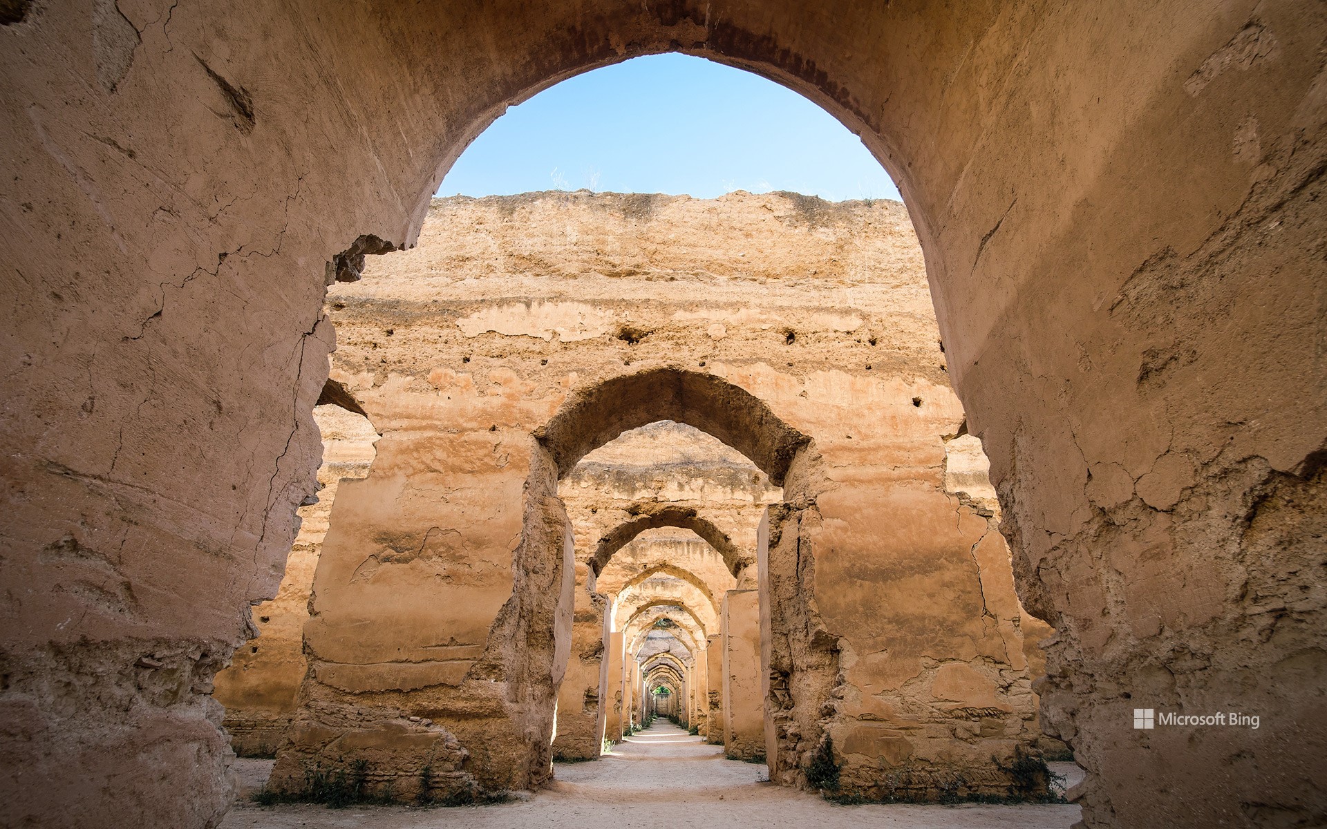
梅克内斯的Heri es-Swani,摩洛哥 Heri es-Swani in Meknes, Morocco (© Calin Stan/Shutterstock)
旧时代的古老拱门 Arches of a bygone era
梅克内斯,摩洛哥
梅克内斯位于摩洛哥中北部,是一座历史悠久的皇家城市。17世纪,阿拉维王朝的苏丹伊斯梅尔·伊本·谢里夫曾将其作为摩洛哥的首都。这座城市以宏伟的城墙、壮丽的城门以及经久不衰的建筑闻名,完美体现了摩洛哥的建筑风格。其中最令人印象深刻的地标之一就是今日图片展示的古城赫里·埃斯·斯瓦尼。
赫里·艾斯-斯瓦尼最初建造为马厩,同时也用于储存大量粮食,供养城市居民和苏丹的军队。这座建筑的设计既实用又令人印象深刻,厚实的墙壁和创新的冷却系统,有效维持了食物储存的稳定性。建筑内部由22排对称拱门将空间分为若干走廊,过去曾有拱形天花板。在当时,骡子会爬到屋顶平台,将粮食通过专门设计的天花板洞口送入下方的储存空间。这里曾经可以容纳多达1.2万匹马,如今,这座建筑仅剩一座空壳,宛如一幅充满历史感的风景画,等待着人们前来探索。对于好奇古代帝国是如何建造和维持的人而言,这座历史古迹无疑是必游之地。
Heri es-Swani in Meknes, Morocco
An imperial city in northern central Morocco, Meknes is steeped in history. Once the capital of Morocco under Sultan Ismail Ibn Sharif of the Alawi dynasty in the 17th century, it's known for its massive walls, grand gates, and structures built to last centuries. Meknes reflects the Moroccan style of architecture, with one of its most impressive landmarks being Heri es-Swani, seen in today's image.
Heri es-Swani was originally constructed as a stable and for storing vast amounts of grain to sustain the settlement and the sultan's armies. Its design was both practical and impressive—thick walls and an innovative cooling system helped maintain the food supply. Twenty-two rows of symmetrical arches divided the space into corridors that once had vaulted ceilings. Back then, mules climbed onto the roof terrace to deliver grain, which was dropped through specially designed holes to the floor below. The structure housed more than 12,000 horses. Today, it stands as an empty shell, acting as a scenic backdrop ready to be explored. This historical monument is a must-see for anyone curious about how empires were built and fed.