2022年9月
日本京都荒山竹林步道 Footpath in the Arashiyama Bamboo Grove, Kyoto, Japan (© Razvan Ciuca/Getty Images)

日本京都荒山竹林步道 Footpath in the Arashiyama Bamboo Grove, Kyoto, Japan (© Razvan Ciuca/Getty Images)
A grove glows green 小树林泛着绿色
arashiyama bamboo forest
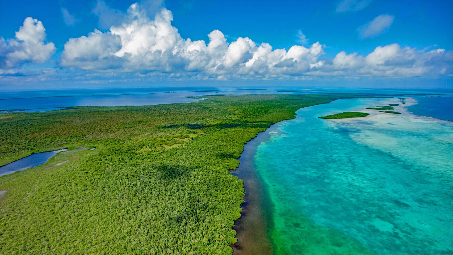
One of the most photographed places in Japan is this otherworldly grove of towering bamboo. The Arashiyama Bamboo Grove in the outskirts of Kyoto is surrounded by temples and shrines along the Katsura River, rising as a manicured oasis of stories-high bamboo that seems to turn the world green. The former villas and temples of the old noble class are located near the Arashiyama Grove, and its single 500-yard path is usually filled with visitors wielding cameras and selfie sticks, making this serene view a rare one.
World Bamboo Day, celebrated September 18, was created in 2009 to bring attention to this useful and versatile plant that flourishes in East Asia. Though the tallest bamboo can grow up to 100 feet, bamboo is not a tree but a grass. Known for its light weight, strength, and rapid growth, bamboo can be used to make almost anything, from clothing to building materials—and its shoots can even be consumed as food. Because it grows as much as 3 feet in a day, it's a highly renewable resource. Though for the same reason, it's also an invasive species in some places, as a small stand of bamboo can quickly become a large one. While bamboo grows best in tropical and warm climates, it adapts well to cool temperatures and high altitudes. And though it might have the most cultural value in Asia, it grows wild in Africa, the Americas, and Australia, too. Could there be bamboo growing near you?
阿拉善竹林
在日本,摄影最多的地方之一是这片超凡脱俗的竹林。京都市郊的荒山竹林被桂树河沿岸的寺庙和神龛所环绕,像一片修剪整齐的绿洲,层层高高的竹子似乎让世界变绿了。昔日贵族阶层的别墅和寺庙位于荒山林区附近,其单条500码长的小径通常挤满了挥舞着相机和自拍棒的游客,这使得这一宁静的景色变得罕见。
2009年9月18日是世界竹节,旨在引起人们对这种在东亚盛产的有用且多功能的植物的关注。虽然最高的竹子可以长到100英尺高,但竹子不是树,而是草。竹子以其重量轻、强度大、生长迅速而闻名,几乎可以用来制造任何东西,从服装到建筑材料,竹笋甚至可以作为食物食用。因为它一天长3英尺,是一种高度可再生的资源。尽管出于同样的原因,它在某些地方也是一种入侵物种,因为一小块竹子很快就会变成一大块。虽然竹子在热带和温暖气候中生长最好,但它能很好地适应凉爽的温度和高海拔。虽然它可能在亚洲具有最重要的文化价值,但它在非洲、美洲和澳大利亚也很野生。你附近有竹子吗?
巴斯利卡塔的卡斯泰尔梅扎诺村,意大利 Village of Castelmezzano, Potenza, Basilicata, Italy (© Roberto Moiola/Getty Images)
巴斯利卡塔的卡斯泰尔梅扎诺村,意大利 Village of Castelmezzano, Potenza, Basilicata, Italy (© Roberto Moiola/Getty Images)
山峦间的光辉之城 Shining city on the hill
Castelmezzano, Italy
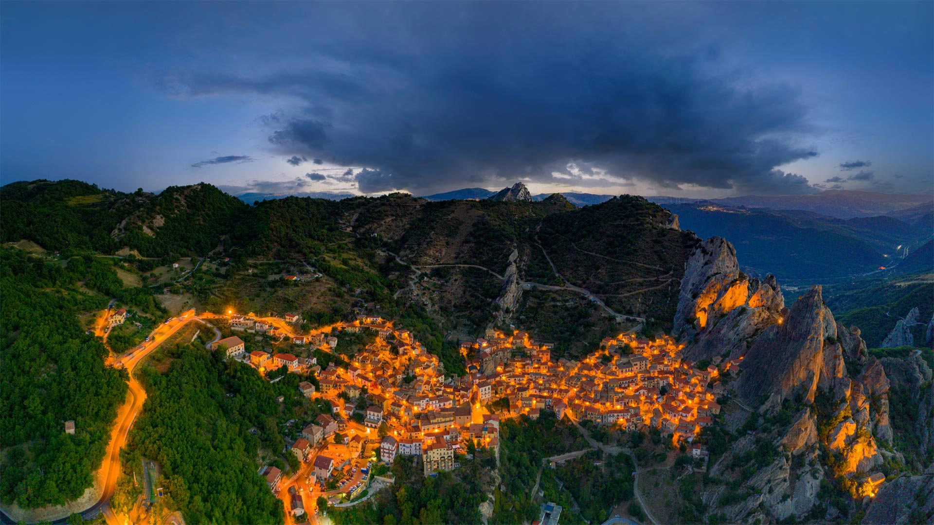
What may appear to be an undulating ribbon of fire clinging to the side of a mountain is actually the medieval village of Castelmezzano, considered one of Italy's most beautiful and undiscovered places. The town is perched along the western side of the San Martino mountains in the southern part of the Italian Peninsula. The population of Castelmezzano has found protection on these craggy cliffs since it was first settled by Greeks around 2,500 years ago. The villagers who live there today speak a distinct but dying variant of Italian, and with an aging population, the village is hopeful it can find new arrivals who appreciate the old ways.
Looking for an unusual journey? Consider visiting Castelmezzano for the Volo dell'Angelo (Angel Flight), a high-speed zip line across the valley between Castelmezzano and neighboring Pietrapertosa that reaches speeds of more than 70 mph more than 1,300 feet off the ground. Hurtling through the air not your thing? Consider the enchanting Percorso delle Sette Pietre (Seven Stones Path), a literary walk based on ancient stories handed down orally. Each of the seven stations you'll visit has a huge stone statue that, as the visitor passes, activates voices and sounds, narratives and music. The 1.5-mile-long path connects the villages of Castelmezzano and Pietrapertosa.
卡斯泰尔梅扎诺,意大利
一条蜿蜒起伏的火带依附在山的一侧,实际上是中世纪的卡斯特尔梅萨诺村,它被认为是意大利最美丽、最未被发现的地方之一。该镇位于意大利半岛南部圣马蒂诺山脉的西侧。自2500年前希腊人首次定居以来,卡斯特尔梅萨诺的居民在这些陡峭的悬崖上找到了保护。今天住在那里的村民讲的是一种独特但即将消失的意大利语变体,随着人口老龄化,该村希望能找到喜欢旧方式的新移民。
寻找不寻常的旅程?考虑乘坐Volo dell’Angelo(天使航班)前往卡斯泰尔梅扎诺,这是一条横跨卡斯泰尔梅扎诺和邻近的彼得拉佩托萨之间山谷的高速拉链线路,其速度超过70英里/小时,离地面1300英尺以上。在空中飞驰不是你的事吗?想想迷人的珀科索·戴尔·塞特·皮特(七石之路),这是一部基于口头流传的古代故事的文学作品。你将参观的七个车站中的每一个都有一个巨大的石雕,当游客经过时,它会激活声音、故事和音乐。这条1.5英里长的小路连接了卡斯泰尔梅扎诺和彼得拉佩托萨两个村庄。
幽鹤国家公园的翡翠湖, 加拿大不列颠哥伦比亚省 (© Cavan Images/Offset)
布莱克浦塔和中央码头,英国兰开夏郡 (© Bailey-Cooper Photography/Alamy)
罗兰豁口上空的银河,法国上比利牛斯省 Milky Way behind Roland's Breach in the Pyrenees, Hautes-Pyrénées, France (© SPANI Arnaud/Alamy)
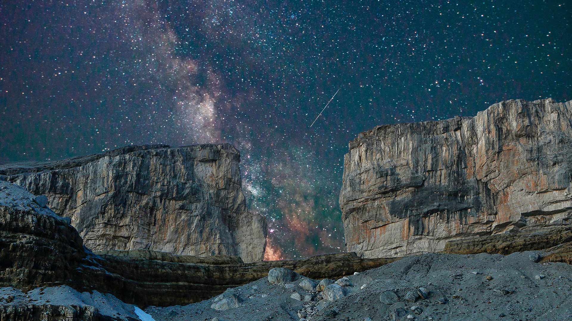
罗兰豁口上空的银河,法国上比利牛斯省 Milky Way behind Roland's Breach in the Pyrenees, Hautes-Pyrénées, France (© SPANI Arnaud/Alamy)
从天而降的魔法 Magic fallen from the sky
Roland's Breach in the Pyrenees
This is the kind of image in front of which one cannot help but emit a "wow" of wonder. We are in front of the Roland's Breach, located on the periphery of the Cirque de Gavarnie, in the Hautes-Pyrénées, and behind which flow the billions of stars of the Milky Way. Very popular with hikers, this gap is a natural hole, 40 meters wide and 70 meters deep. Located at an altitude of 2807 meters, it plays the role of a mountain pass which marks the border between Spain and France on all its width.
According to the legend, the breach was created by Roland, Charlemagne's nephew, while he was trying to destroy his sword by hitting it against the rock.
The Cirque de Gavarnie is one of the most impressive sites in the French Pyrenees and was even listed as a UNESCO World Heritage Site in 1997.
比利牛斯山脉的罗兰豁口
这是一种让人忍不住发出“哇”一声惊叹的图像。我们就在罗兰豁口的前面,位于上皮雷内的加瓦尼圆环的边缘,银河系的数十亿颗恒星就在这一缺豁口的后面。非常受徒步旅行者欢迎,这个豁口是一个天然的洞,宽40米,深70米。它位于海拔2807米处,起着山口的作用,在整个宽度上标志着西班牙和法国之间的边界。
根据传说,这个豁口是查理曼大帝的侄子罗兰(Roland)创造的,当时他正试图用剑撞击岩石来摧毁他的剑。
大理石峡谷中横跨科罗拉多河的纳瓦霍桥,美国亚利桑那州北部 Marble Canyon bridges over the Colorado River at the Glen Canyon National Recreation Area in northern Arizona (© trekandshoot/Alamy)
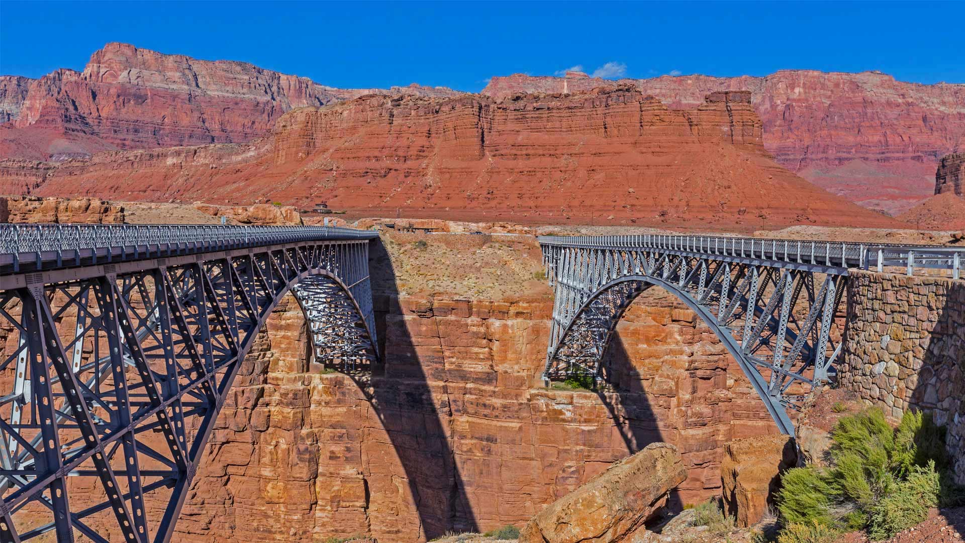
大理石峡谷中横跨科罗拉多河的纳瓦霍桥,美国亚利桑那州北部 Marble Canyon bridges over the Colorado River at the Glen Canyon National Recreation Area in northern Arizona (© trekandshoot/Alamy)
横跨峡谷裂缝的两座桥 Bridging the gap two ways
Happy birthday, bridges
Today we're taking a trip to a part of northern Arizona cut off from the rest of the state by the Colorado River and its deep canyons. No doubt you've heard of the Grand Canyon, but today is an important milestone to another canyon about 70 miles away. On this date in 1995, the twin Marble Canyon bridges, better known collectively as Navajo Bridge, were officially dedicated as the second bridge was installed.
The first, in place since 1929 when it was hailed as a 'modern marvel' and 'the biggest news in Southwest history,' had long been key to travel across the 834-foot gap of Marble Canyon. But as time passed, the area saw heavier vehicles and more traffic. After much debate about the impact on Native land and endangered plants, and the likelihood of debris falling into the river below, plans were developed for the $14.7 million, nearly identical second bridge. Now, Marble Canyon has two bridges, each about 470 feet over the Colorado River. The original serves as a path for humans and horses while the new bridge carries vehicles. Both bridges hold the title of ninth-highest in the United States (though the newer one is about three feet higher).
生日快乐,桥
今天,我们将前往亚利桑那州北部的一个地区,那里被科罗拉多河及其深峡谷与该州的其他地区隔绝。毫无疑问,你听说过大峡谷,但今天是70英里外另一个峡谷的重要里程碑。1995年的这一天,两座大理石峡谷大桥(合称纳瓦霍桥)正式投入使用,第二座大桥也安装完毕。
自1929年被誉为“现代奇迹”和“西南历史上最大的新闻”以来,第一条铁路一直是穿越834英尺高的大理石峡谷的关键。但随着时间的推移,该地区的车辆越来越重,交通也越来越多。在对当地土地和濒危植物的影响以及碎片落入河流的可能性进行了大量辩论后,为价值1470万美元、几乎相同的第二座桥梁制定了计划。现在,大理石峡谷有两座桥,每座桥跨越科罗拉多河约470英尺。最初的桥梁是人和马的通道,而新的桥梁则承载车辆。这两座桥都是美国第九高的桥梁(尽管较新的桥高约三英尺)。
大沙丘国家公园和保护区,美国科罗拉多州 Great Sand Dunes National Park and Preserve, Colorado (© Y Paudel/Getty Images)
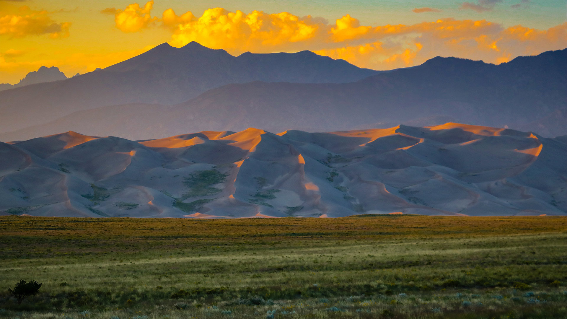
大沙丘国家公园和保护区,美国科罗拉多州 Great Sand Dunes National Park and Preserve, Colorado (© Y Paudel/Getty Images)
如沙漏中的沙子一般 Like sands through the hourglass
Great Sand Dunes National Park and Preserve
Today we celebrate the birthday of Great Sand Dunes National Park and Preserve, which boasts 750-foot (and higher) sand dunes that cover more than 30 square miles. But the towering hills of sand—the tallest in North America—are just one feature of an eye-popping Colorado landscape that includes conifer forests, alpine lakes, and wetlands. The 85,000-acre park and preserve even encompasses stretches of tundra at the higher elevations, where it edges up against the base of the Sangre de Cristo Mountains.
Initially proclaimed a national monument in 1932 by President Herbert Hoover, the territory was redesignated as Great Sand Dunes National Park and Preserve on September 13, 2004, and the size of the park was quadrupled. The park and preserve provide ample and wildly diverse activities for visitors, from sandboarding and sandsledding down the steep dunes to hiking, camping, horseback riding, and fat-tire biking.
大沙丘国家公园和保护区
今天,我们庆祝大沙丘国家公园和保护区(Great Sand Dunes National Park and Preserve)的生日,该保护区拥有750英尺(或更高)的沙丘,面积超过30平方英里。但北美最高的高耸沙山只是科罗拉多州令人瞠目的景观的一个特征,包括针叶林、高山湖泊和湿地。85000英亩的公园和保护区甚至包括高海拔地区的苔原,在那里,它与桑格雷德克里斯托山脉的底部相对。
1932年,赫伯特·胡佛总统首次宣布该地区为国家纪念碑,2004年9月13日,该地区被重新指定为大沙丘国家公园和保护区,公园面积增加了四倍。公园和保护区为游客提供了丰富多样的活动,从在陡峭的沙丘上划沙板和玩沙橇到徒步旅行、露营、骑马和骑自行车。
在喀拉拉邦河流中行驶的一艘小船,印度 Aerial view of a boat in Kerala, India (© Shutterstock)
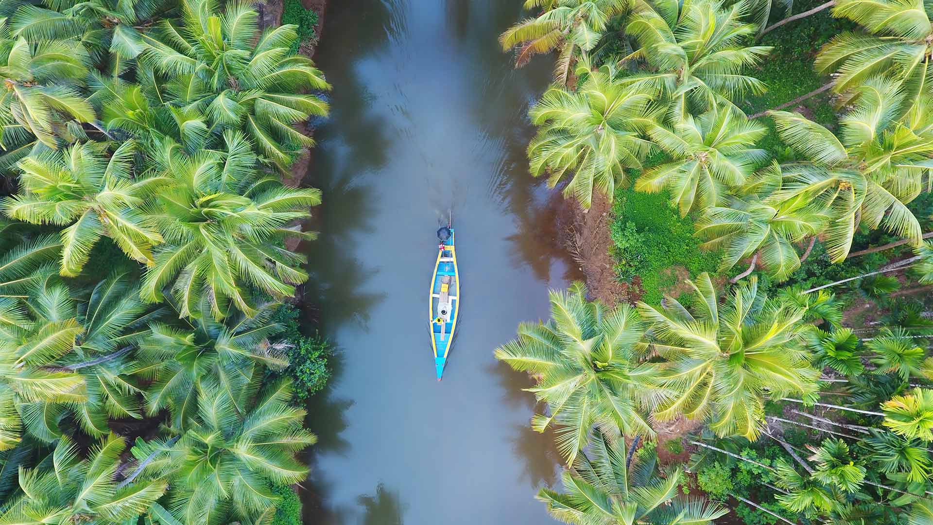
在喀拉拉邦河流中行驶的一艘小船,印度 Aerial view of a boat in Kerala, India (© Shutterstock)
椰林国 Coconut forest country
Kerala, India
Kerala, the southernmost state of India, is the spice hotspot of the world since ancient times. This beautiful land is rightly called God's Own Country, given to its lush green landscapes and crystal-clear beaches that will leave you awestruck. With all elements of nature in it, Kerala leads the country in various aspects like literacy rate, sex ratio, least population growth, and travel and tourism.
The name Kerala is derived from Kera, the local Malayalam word for coconut, and there is an abundance of palm trees across the state. The spiky dark green fronds act as natural parasols against the glare of the sun. The coconut doesn’t just lend its name to the place but also acts as a ubiquitous and adaptable natural resource from which countless products, such as coir, a versatile fiber, and toddy, a famous – and potent – local brew, are derived.
印度喀拉拉邦
印度最南端的喀拉拉邦自古以来就是世界香料热点。这片美丽的土地被正确地称为上帝的祖国,因其葱郁的绿色景观和水晶般清澈的海滩将让你惊叹不已。喀拉拉邦拥有自然的所有元素,在识字率、性别比、人口增长最少、旅游和旅游等各个方面都处于全国领先地位。
喀拉拉这个名字来源于当地马来语中椰子的意思Kera,整个州有大量的棕榈树。尖尖的深绿色复叶充当天然遮阳伞,抵御太阳的强光。椰子不仅是这个地方的名字,而且是一种无处不在、适应性强的自然资源,从中可以提炼出无数产品,如椰子皮(一种多用途纤维)和托迪酒(一种著名且有效的当地酿造酒)。
中秋之夜, 上海豫园 Shanghai Yu yuan gardens at night, mid-autumn (© Zyxeos30/Getty images)
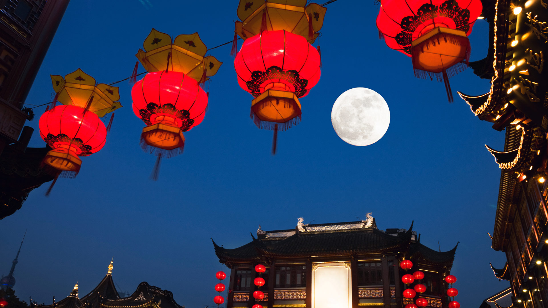
中秋之夜, 上海豫园 Shanghai Yu yuan gardens at night, mid-autumn (© Zyxeos30/Getty images)
海上生明月,天涯共此时 Full moon were reunited!
Mid-Autumn Festival
The Mid-Autumn Festival, also known as the Moon Festival or Mooncake Festival, is a traditional festival celebrated in Chinese culture. It is one of the most important holidays in Chinese culture; its popularity is on par with that of Chinese New Year. The history of the Mid-Autumn Festival dates back over 3,000 years.
Lanterns of all sizes and shapes are carried and displayed – symbolic beacons that light people's path to prosperity and good fortune. Mooncakes, a rich pastry typically filled with sweet bean, egg yolk, meat, or lotus-seed paste, are traditionally eaten during this festival. The Mid-Autumn Festival is based on the legend of Change, the Moon goddess in Chinese mythology.
中秋节
中秋节,又称中秋节或月饼节,是中国文化中的一个传统节日。这是中国文化中最重要的节日之一;它的受欢迎程度与中国新年不相上下。中秋节的历史可以追溯到3000多年前。
各种大小和形状的灯笼被携带和展示——象征性的灯塔,照亮人们通往繁荣和好运的道路。月饼是一种富含甜豆、蛋黄、肉或莲子酱的糕点,传统上在节日期间食用。中秋节是基于中国神话中月亮女神的传说。