标签 桥 下的文章
塞纳河,巴黎,法国 River Seine, Paris, France (© StockByM/Getty Images)
塞纳河,巴黎,法国 River Seine, Paris, France (© StockByM/Getty Images)
一座承载历史的桥 A bridge that holds up history
塞纳河上的桥,巴黎,法国
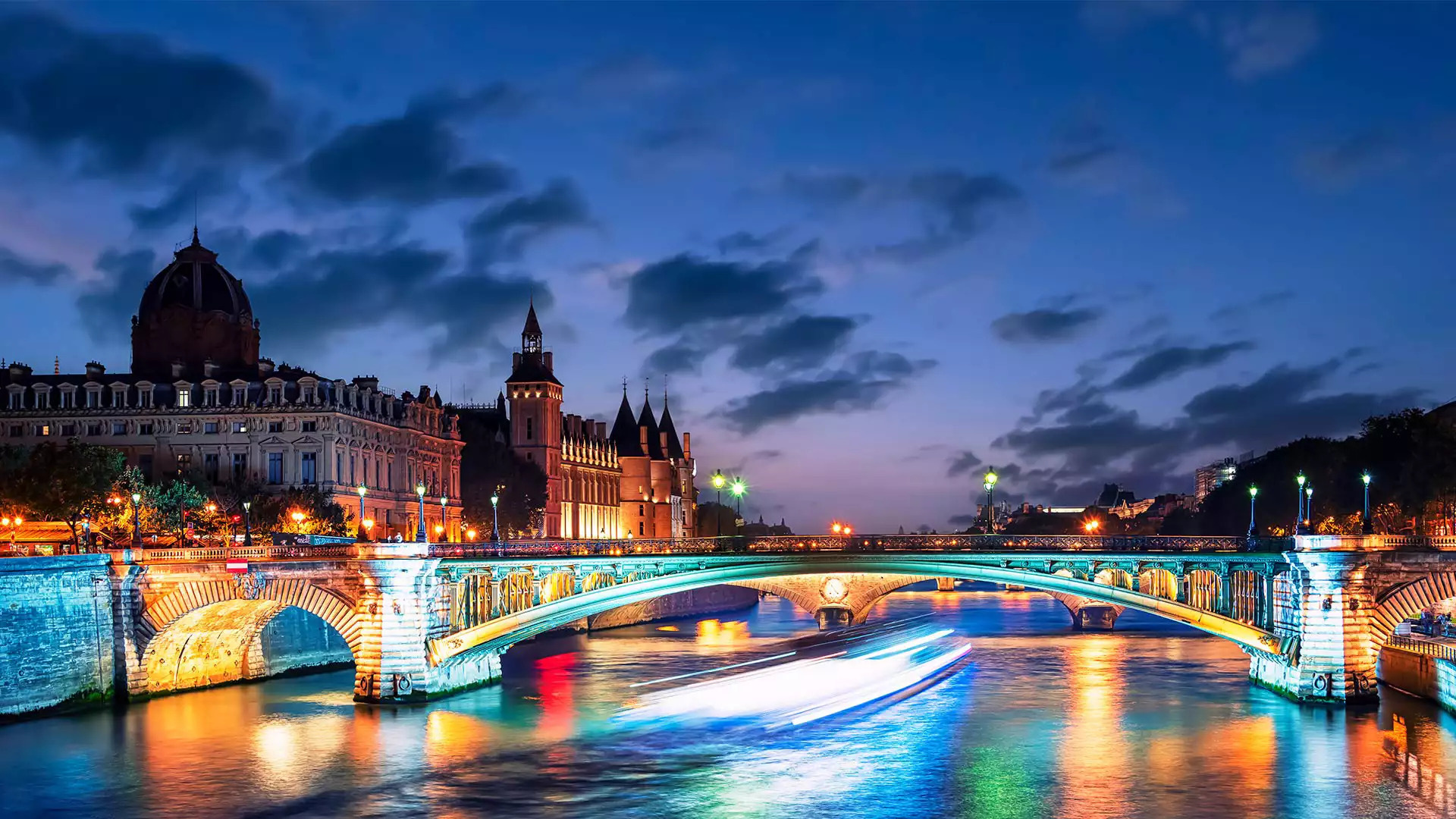
塞纳河流经法国巴黎,对这座古城的历史有着非比寻常的意义。公元前3世纪,一个名为帕里西人的凯尔特部落决定定居在塞纳河两岸之间的一座岛屿,即如今的西岱岛。在接下来的数个世纪里,塞纳河在巴黎发展成为全球商业和文化中心的过程中发挥了重要作用。
塞纳河穿过巴黎的河道十分辽阔,许多桥梁都横跨其间。巴黎共有37座普通桥梁和步行桥连接着城市的左右两岸。图中的映衬着落日的阿尔科勒桥在巴黎人心中占据着历史性地位,因为它在1944年为勒克莱尔将军解放巴黎的坦克提供了通道。
Pont d'Arcole over the Seine river, Paris, France
Welcome to Paris, France’s ancient capital city, through which flows one of the country’s longest rivers, the Seine. Human habitation here dates back to at least the 3rd century BCE, when a Gallic tribe called the Parisii settled on an island in the middle of the river. Today, that island is known as the Île de la Cité, seen on the left of our photo, and is home to Notre-Dame cathedral, as well as other striking buildings such as the medieval Conciergerie, pictured here.
It is linked to the Place de l'Hôtel-de-Ville by the Pont d’Arcole, one of 37 bridges connecting the city’s left and right banks. The Pont d’Arcole was built in the 1850s and holds a special place in Parisiennes’ hearts. In 1944, it supported General Jacques-Philippe Leclerc's tanks on their way to liberate Paris.
加利福尼亚州圣克鲁斯的天然桥州立公园 Natural Bridges State Beach in Santa Cruz, California (© Jim Patterson/Tandem Stills + Motion)
加利福尼亚州圣克鲁斯的天然桥州立公园 Natural Bridges State Beach in Santa Cruz, California (© Jim Patterson/Tandem Stills + Motion)
通往太平洋之窗 A window to the Pacific
天然桥州立公园,加利福尼亚州,美国
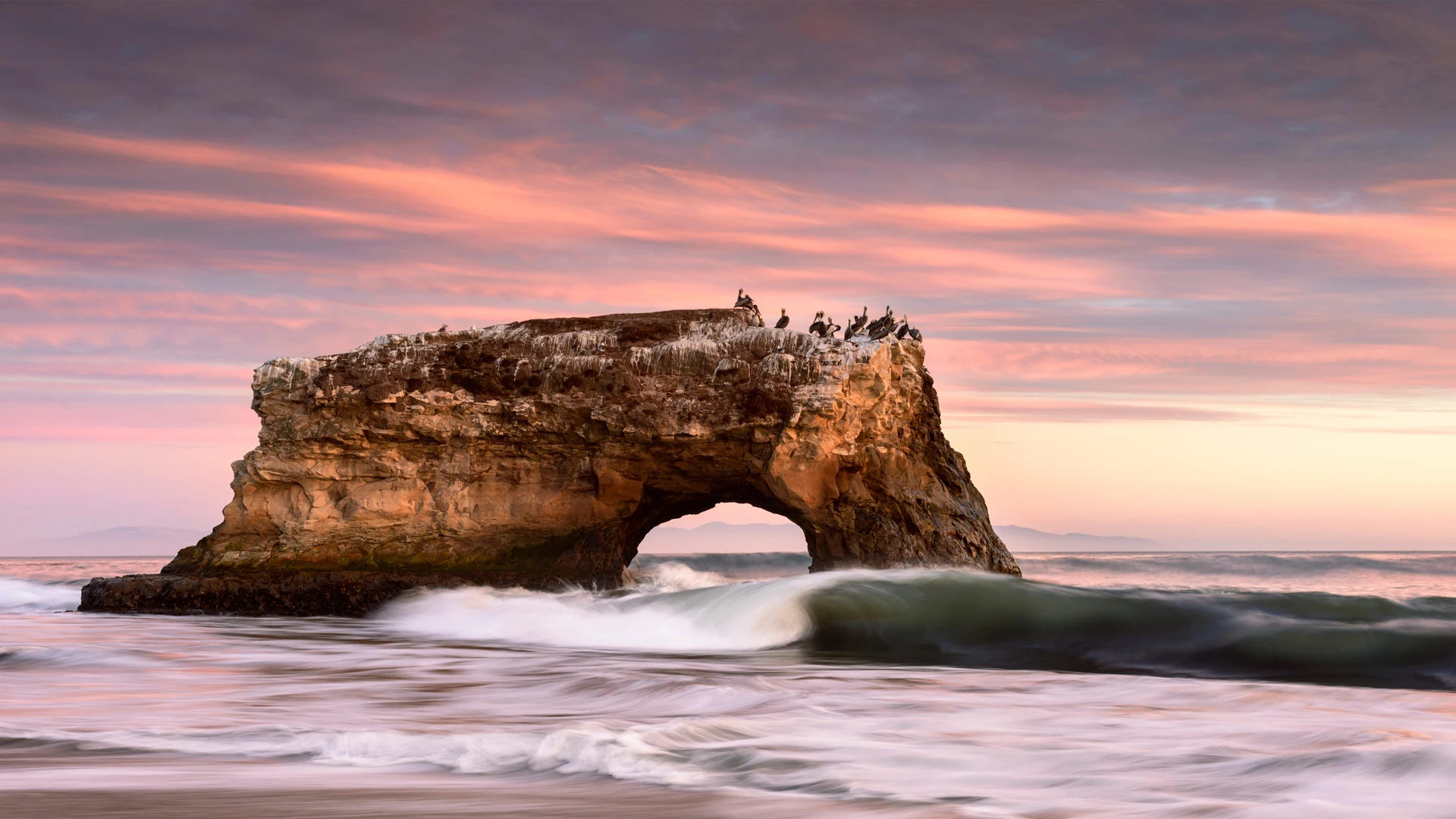
天然桥州立公园位于美国加利福尼亚州的圣克鲁斯市。初期,这里有三座海水侵蚀而成的拱桥,其中一座于1905年倒塌,后来又有一座于1980年倒塌,剩下我们如今看到的这座拱桥。然而,海浪的侵蚀是无情的,因此仅剩的这座拱桥最终也会倒塌。除了拱桥,这个公园还有君主斑蝶,因此也吸引了不少游客。
Natural Bridges State Beach in Santa Cruz, California
California brown pelicans, cormorants, and gulls enjoy jostling for position on top of this stunning rock formation in Natural Bridges State Beach in Santa Cruz. It is the sole surviving natural 'bridge' in this state park. Once three bridges stood side-by-side here, carved by waves into cliffs that jutted out into the Pacific. This one stood in the middle, but the outermost bridge collapsed in 1905 and the innermost one disappeared in 1980.
The erosion of the waves is relentless, so eventually the final arch will collapse, and the birds will have to find another favorite perch. But there are plenty of other views on offer. The park is also a seasonal home to migratory monarch butterflies, which flutter through the air or cluster together in its eucalyptus grove. And if you're lucky, you might spot a migrating whale or see seals and otters playing offshore.
横跨圣劳伦斯河下游的魁北克大桥,加拿大 Quebec Bridge across the lower Saint Lawrence River, Canada (© Ronald Santerre/Getty Images)
横跨圣劳伦斯河下游的魁北克大桥,加拿大 Quebec Bridge across the lower Saint Lawrence River, Canada (© Ronald Santerre/Getty Images)
工程学杰作 A masterpiece of engineering
魁北克大桥,加拿大
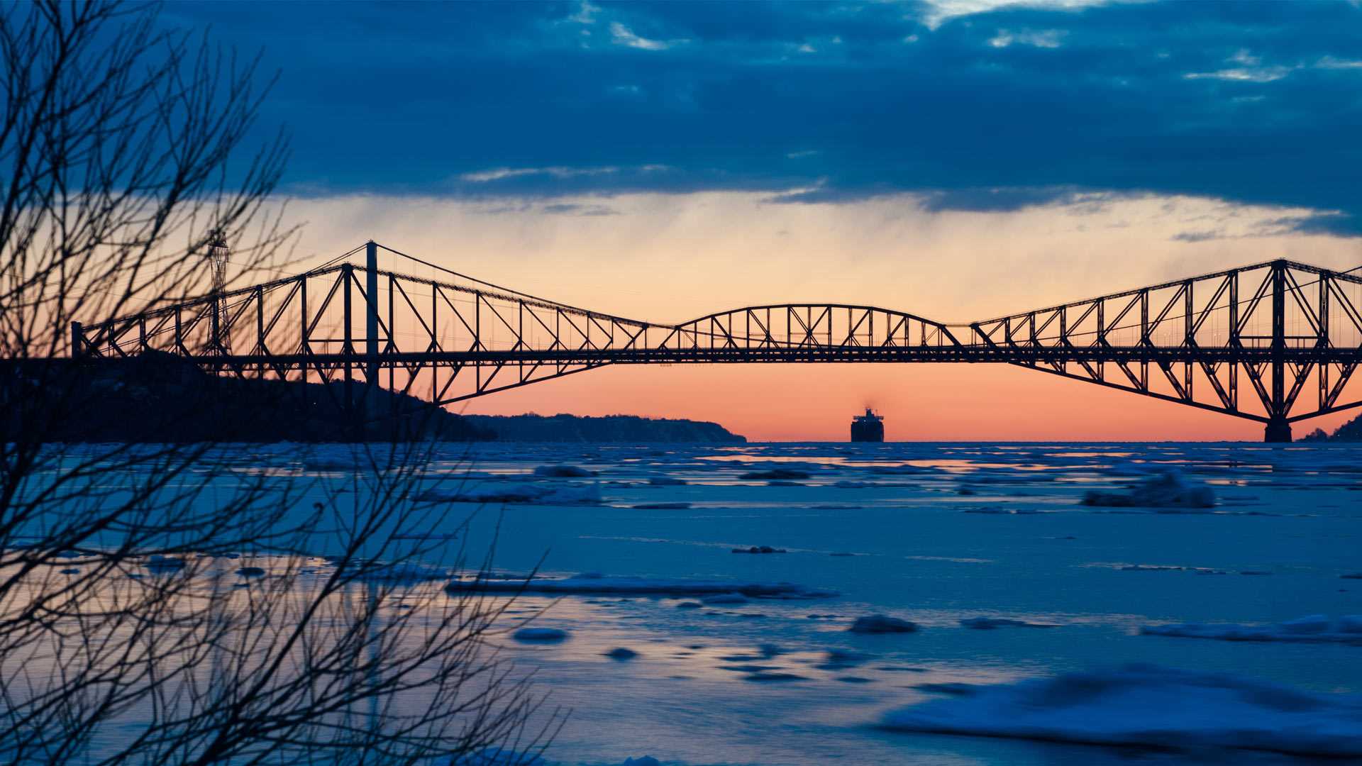
魁北克大桥是一座跨越圣劳伦斯河下游的公路、铁路、行人三用桥,连接加拿大魁北克省的桑特富瓦和莱维斯。魁北克大桥是一个工程学杰作,两座桥墩之间有549米长的主跨。魁北克大桥是世界上最长的悬臂桥,比苏格兰的福斯桥还长了27米。
1907年8月29日,这座桥在建设过程中垮塌了。事故之后,政府接手了建设工程。1913年,大桥的建设重启。新的设计增加了大桥主要应力结构的横截面面积,几乎是之前的2倍。但是悲剧重演了。在经历了两次悲剧后,魁北克大桥最终在1917年完工通车。
Asian American and Pacific Islander Heritage Month
This stunning structure is the stone pavilion housing the massive Korean Bell of Friendship in Los Angeles, a city with a large Korean American population. It's ringing in Asian American and Pacific Islander (AAPI) Heritage Month, which starts today. The month was chosen in recognition of the first documented arrival of Japanese immigrants, on May 7, 1843, and the completion of the transcontinental railroad by more than 20,000 Asian immigrants on May 10, 1869.
Back to that intricately decorated bronze bell. It was a gift to the city from South Korea to mark the US bicentennial in 1976 and is modeled on the largest bell cast in Korean history, the Divine Bell of King Seongdeok, made in 771. Both versions are among the largest bells in the world.
科尔多瓦的古罗马桥,西班牙 Roman bridge, Córdoba, Spain (© Jeremy Woodhouse/Getty Images)
科尔多瓦的古罗马桥,西班牙 Roman bridge, Córdoba, Spain (© Jeremy Woodhouse/Getty Images)
这座古桥在哪呢? Where is this historical bridge?
古罗马桥,科尔多瓦,西班牙
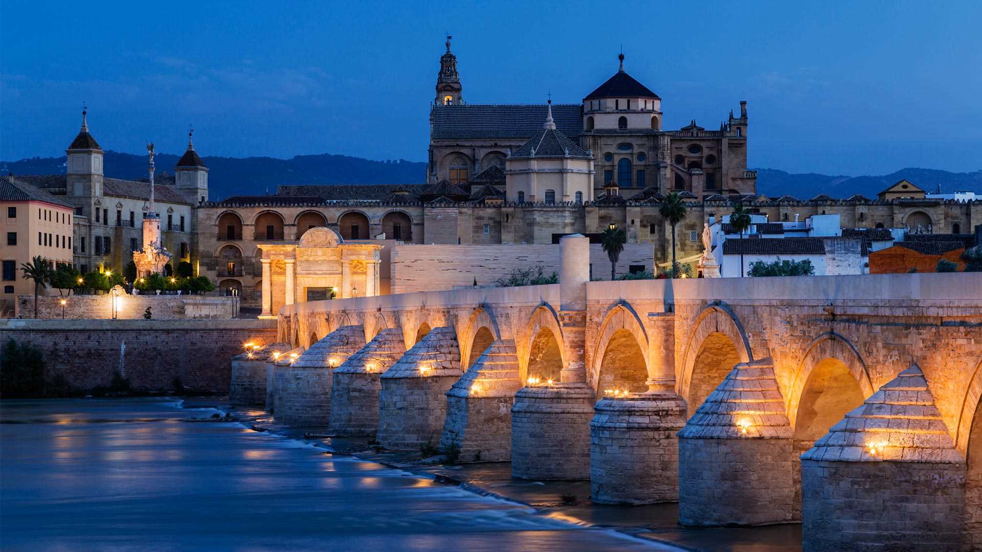
科尔多瓦的古罗马桥跨越瓜达尔基维尔河,是这座城市的一处历史地标。这座桥始建于公元前1世纪罗马帝国的扩张时期,在历史上曾被多次重建,目前这座桥的主体是在8世纪由阿拉伯人重建。虽然它已经承载了数个世纪的交通往来,但现在这座桥仅供行人通行。如果你觉得它很眼熟,可能是因为你曾在《权力的游戏》第五季中见过它,在剧中它是虚构的瓦兰提斯城的一部分。
Roman bridge of Córdoba, Spain
The Roman bridge of Córdoba, in the ancient Spanish city’s historic center, has been rebuilt several times over the centuries. For 2,000 years it was the city’s only bridge across the Guadalquivir River, originally built in the first century BCE during the expansion of the Roman Empire. Much of the current bridge dates from reconstruction in the 8th century following the Moorish conquest, a period when hundreds of mosques and palaces were built, and Córdoba became one of Europe's largest cities and a center of learning and culture.
While it has seen centuries of traffic, the bridge is now only open to pedestrians, following the opening of the Miraflores Bridge in 2004. If it looks familiar, you might have spotted it standing in as part of the fictional city of Volantis in 'Game of Thrones.'
斯太尔河, 奥地利 Steyr River, Austria (© guenterguni/Getty Images)
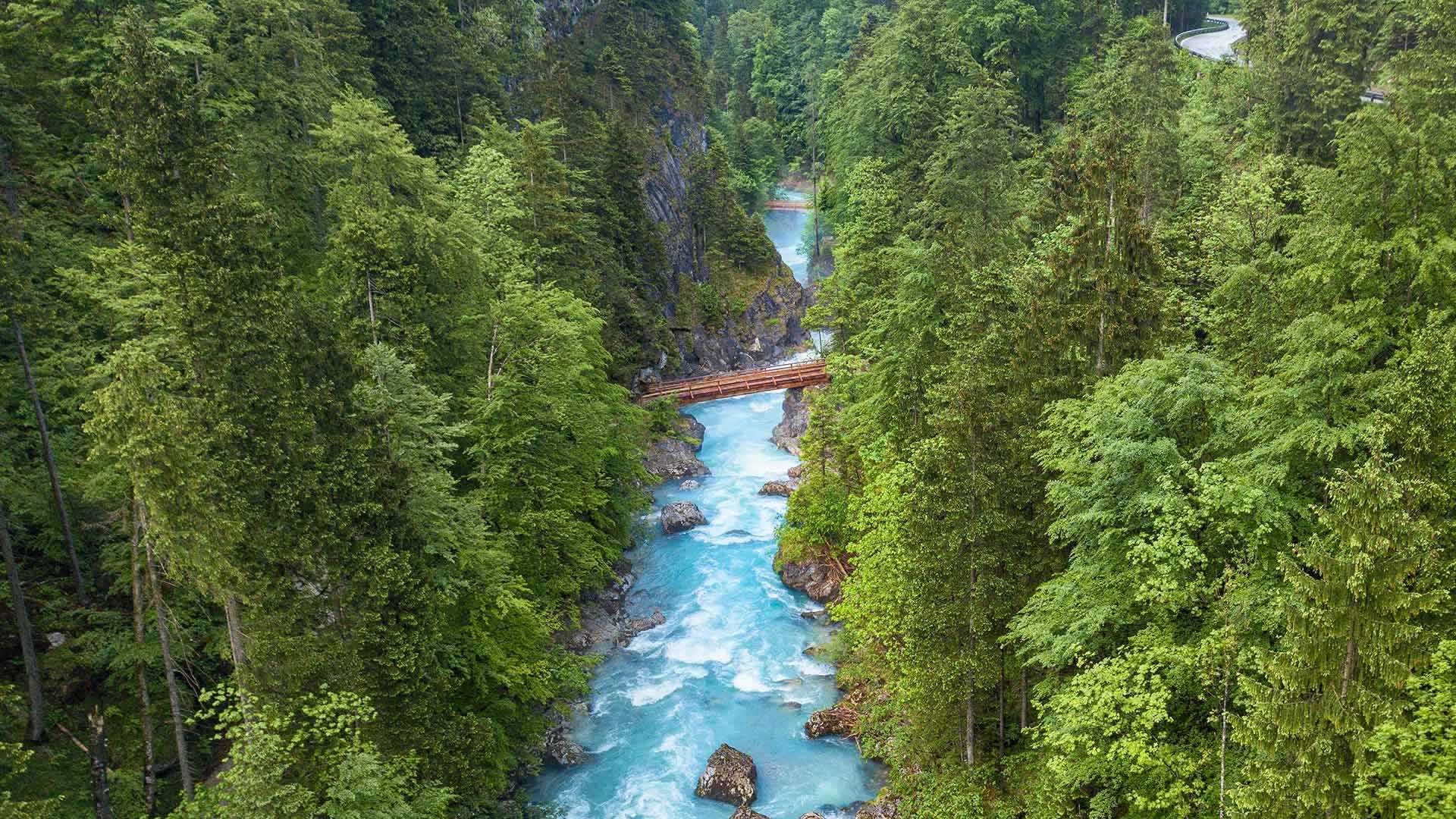
斯太尔河, 奥地利 Steyr River, Austria (© guenterguni/Getty Images)
大自然的蓝色奇观 Nature's blue wonder
斯太尔河,奥地利
今天这张照片并未经过调色,奥地利斯太尔河的水真的就是这般湛蓝。斯太尔河流经托特斯山脉,当地植被稀少,那为什么斯太尔河还能如此清澈湛蓝?答案就在环绕斯太尔河谷的群山之中。雨水和融化的雪水流入斯太尔河后,其中较重的沉积物沉到水底,而较细的沉积物则会悬浮在水中。被沉积物散射或反射的阳光就赋予了河水这样鲜艳的蓝色。
Steyr River, Austria
These whitewater rapids are found in Upper Austria, where the Steyr River crashes down from the barren Totes Gebirge (the Dead Mountains) through this verdant landscape. When it comes to the ancient town of Steyr, at the foot of the Alps, it will meet the Enns River, which flows into the Danube.
What gives the Steyr that stunning blue hue? The answer is found in the mountains themselves. When there's rainfall or the surrounding snow melts, eroded sediment flows into the river. Heavier sediment sinks to the bottom and finer sediment stays suspended in the water. Sunlight is scattered or reflected by the sediment, allowing us to see a vibrant shade of blue, as the Steyr crashes through this lush landscape.
新年跨年夜烟花, 悉尼悉尼海港大桥, 澳大利亚 New Year's Eve fireworks, Sydney Harbour Bridge in Sydney, Australia (© Wendell Teodoro/Getty Images)
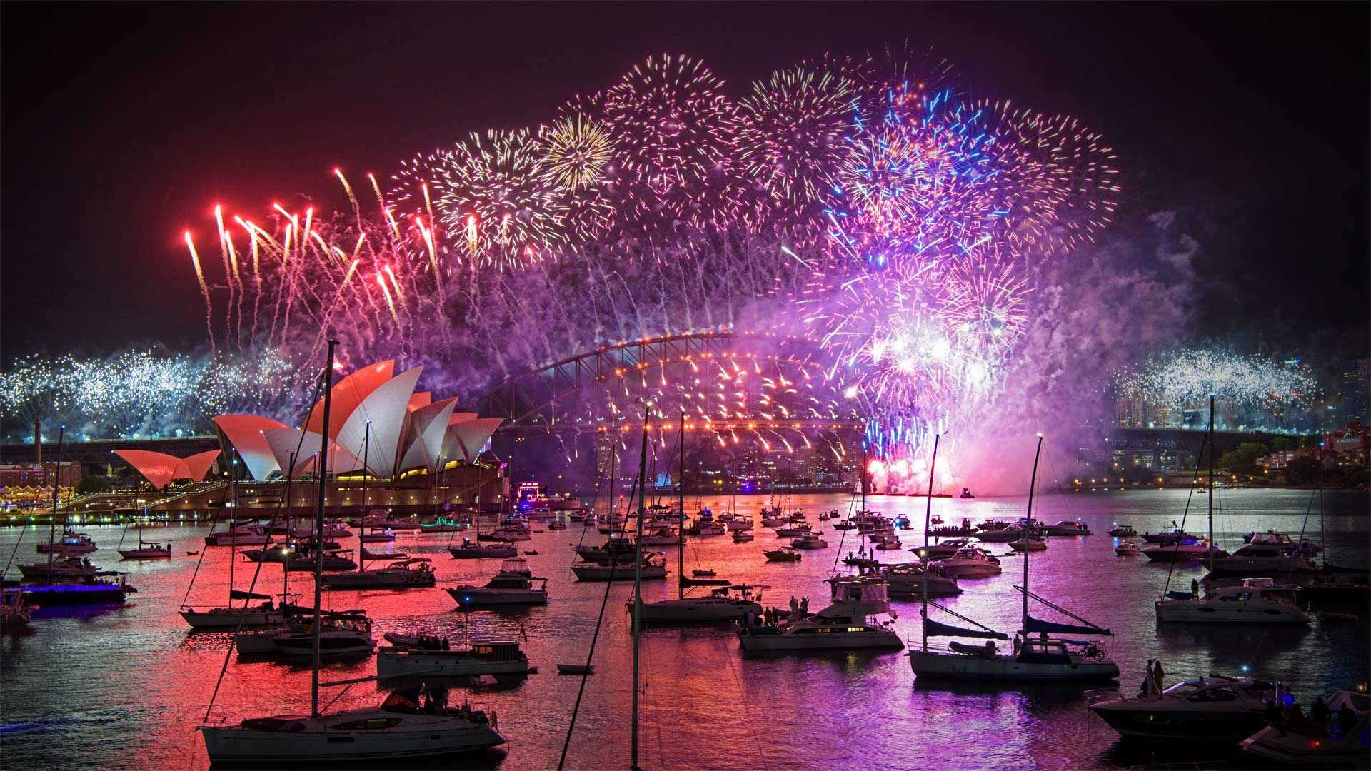
新年跨年夜烟花, 悉尼悉尼海港大桥, 澳大利亚 New Year's Eve fireworks, Sydney Harbour Bridge in Sydney, Australia (© Wendell Teodoro/Getty Images)
跨年夜新年快乐 Happy New Year's Eve from down under
迎接2023年 / 澳大利亚悉尼跨年夜
随着跨年夜在盛夏登陆,许多澳大利亚人选择乘船游览美丽的悉尼港,参加一年一度的烟花表演,以此迎接新年。悉尼海港大桥和举世闻名的悉尼歌剧院作为戏剧背景,今年的第一场烟花表演将于当地时间晚上9点举行,随后在午夜举行第二场。澳大利亚是最早进入新年的国家之一,通常有超过150万人参加悉尼的这一盛大庆祝活动。
每年公历1月1日,标志着新一年的到来,人们习惯将这一天称为“元旦”,俗称“公历年”、“阳历年”或“新历年”。在很多国家,有自己的新年,或是因习俗传统,或者是宗教性的,例如:中国春节,伊斯兰新年,泰米尔新年和犹太新年。
由于地球被划分为多个时区,所以每个时区迎来新年的时间不一,第一个迎来新年的时区,就在国际日期变更线以西,位于莱恩群岛,是基里巴斯国的一部分,时区比世界标准时间早14小时。无人居住的美国边远领土豪兰岛和贝克岛被指定位于UTC后12小时的时区内,这是地球上最后一个看到1月1日到来的地方。
New Year's Eve in Sydney, Australia
With New Year's Eve landing in midsummer, many Aussies choose to usher in the new year with a boat trip around beautiful Sydney Harbour to take in the annual fireworks display With the Sydney Harbour Bridge and world-famous Sydney Opera House as a dramatic backdrop, the first fireworks show will fire off this year at 9 pm local time, followed by a second show at midnight. Australia is one of the first nations to reach the new year, and more than 1.5 million people are typically in attendance for this spectacular celebration in Sydney.
威拉米特国家森林麦肯齐河步道上的桥,美国 Bridge on the McKenzie River Trail, Willamette National Forest, Oregon (© Don Paulson/Danita Delimont)
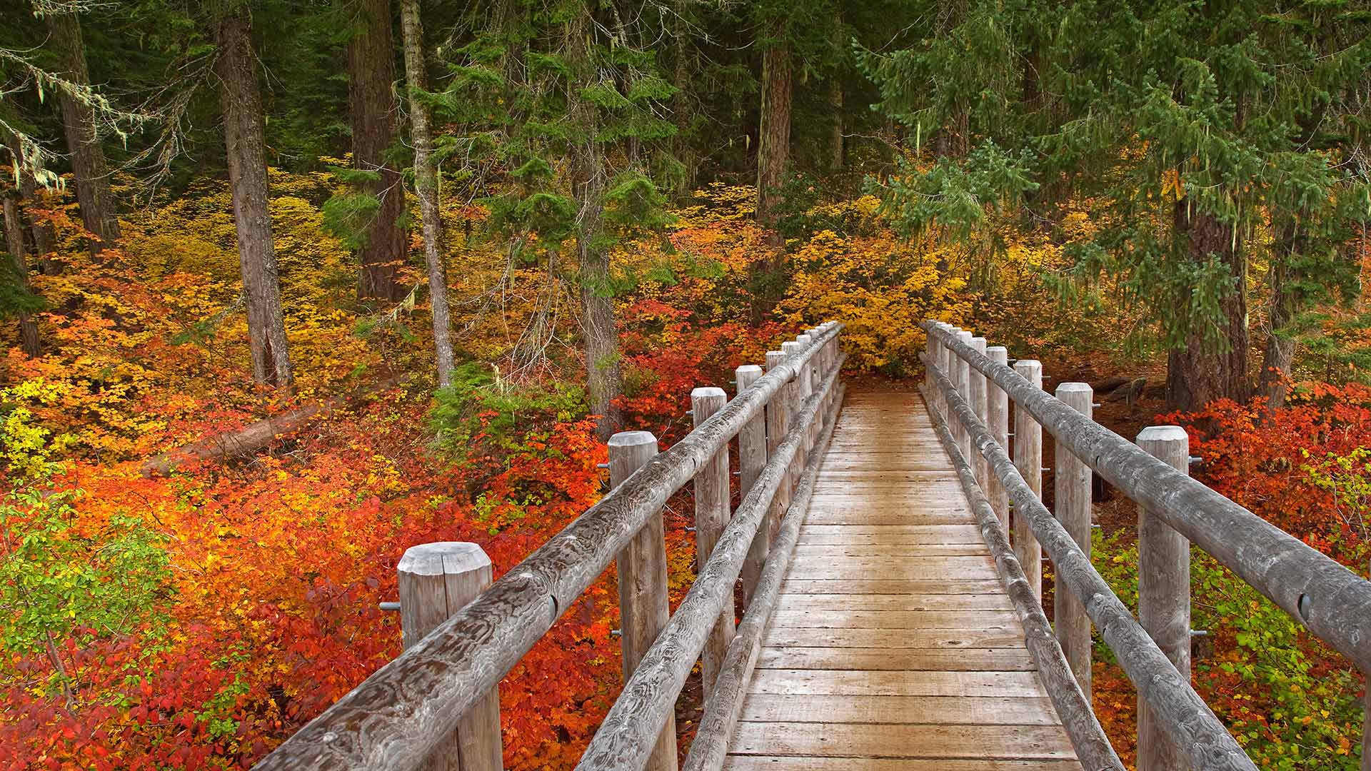
威拉米特国家森林麦肯齐河步道上的桥,美国 Bridge on the McKenzie River Trail, Willamette National Forest, Oregon (© Don Paulson/Danita Delimont)
徒步旅行 Take a hike!
麦肯齐河步道上的桥梁
我们的照片显示俄勒冈州的麦肯齐河国家休闲步道,威拉米特国家森林的一部分。这条小径蜿蜒于湖泊、河流和泉水之间,引导您穿过荫蔽的古老森林。其中一个亮点是可以俯瞰塔莫利奇蓝池(Tamolich Blue Pool),这是一个清澈见底的游泳池,由河水注入其中而成。
Bridge on the McKenzie River Trail
Our photo shows Oregon's McKenzie River National Recreation Trail, part of the Willamette National Forest. This trail winds by lakes, rivers, and springs, guiding you through shady old-growth forests. One highlight: the view overlooking Tamolich Blue Pool, a crystal-clear pool created by the river bubbling up into it.
1990年纽约市马拉松比赛,参赛者穿过韦拉扎诺海峡大桥 Runners in the 1990 New York City Marathon crossing the Verrazzano-Narrows Bridge (© David Madison/Getty Images)
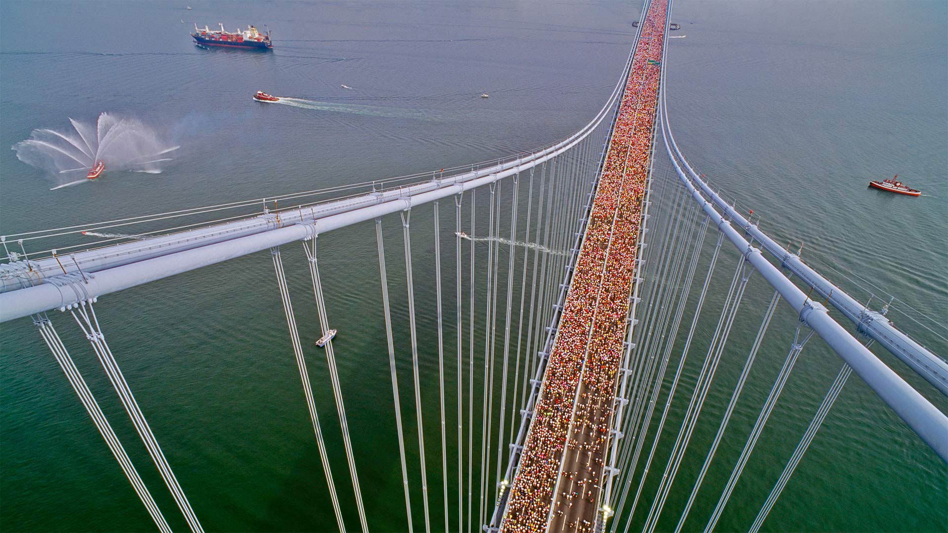
1990年纽约市马拉松比赛,参赛者穿过韦拉扎诺海峡大桥 Runners in the 1990 New York City Marathon crossing the Verrazzano-Narrows Bridge (© David Madison/Getty Images)
跑过纽约五个行政区 Racing through the five boroughs
韦拉扎诺海峡大桥
2022年纽约市马拉松赛的路线就从这里开始,在韦拉扎诺海峡大桥,从斯塔顿岛(Staten Island)穿过布鲁克林(Brooklyn),最终穿过纽约的五个自治区。这张照片让你知道今天将有多少人跑步。因为比赛在11月的一个早晨很早就开始了,许多跑步者都穿着分层的衣服来抵御典型的寒冷。但一旦它们从跑步中升温,这些层就会脱落,经常被丢弃在人行道上。比赛组织者收集每年约26吨的遗留下来的运动装备,并将其捐赠给慈善机构。
Verrazzano-Narrows Bridge
The route for the 2022 New York City Marathon starts right here at the Verrazzano-Narrows Bridge, crossing from Staten Island into Brooklyn, eventually coursing through all five boroughs of New York. This photo gives you an idea of just how many people will be running today. Because the race starts early on a November morning, many runners show up in layered clothing to beat the typical chill. But once they heat up from running, those layers come off and are often discarded on sidewalks. Race organizers collect the activewear left behind, about 26 tons a year, and donate it to charity.
意大利威尼斯的叹息桥 Bridge of Sighs in Venice, Italy (© Doug Pearson/Alamy)
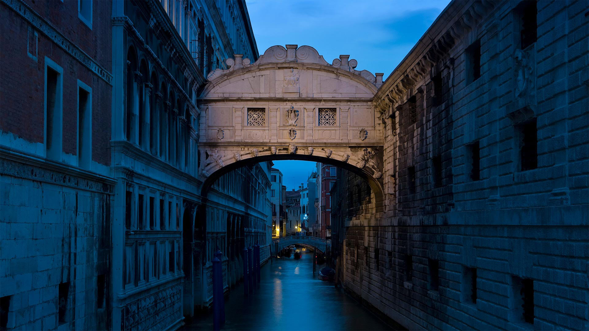
意大利威尼斯的叹息桥 Bridge of Sighs in Venice, Italy (© Doug Pearson/Alamy)
一个吻和一声叹息 A kiss and a sigh
意大利威尼斯叹息桥
在威尼斯的叹息桥(Ponte dei Sospiri)下,当你的船夫引导你穿过城市的运河时,是亲吻你心爱的人的好去处。但这个名字所指的叹息并不是因为你凝视着你亲爱的眼睛。这座封闭的桥于1600年完工,将新监狱(Prigioni Nuove)与总督府的审讯室连接起来,据说囚犯最后一次看到美丽的威尼斯是在这座桥上。这足以让人叹息。
Bridge of Sighs in Venice, Italy
Beneath Venice's Ponte dei Sospiri (Bridge of Sighs), is a popular place to kiss your beloved as your gondolier guides you through the city's canals. But the sighs that the name refers to aren't from staring into your darling's eyes. The enclosed bridge, completed in 1600, connects the Prigioni Nuove (New Prison) to the interrogation rooms in the Doge's Palace, and it is said that a prisoner's last look at beautiful Venice would be on that bridge. And that's reason enough to sigh indeed.
大理石峡谷中横跨科罗拉多河的纳瓦霍桥,美国亚利桑那州北部 Marble Canyon bridges over the Colorado River at the Glen Canyon National Recreation Area in northern Arizona (© trekandshoot/Alamy)
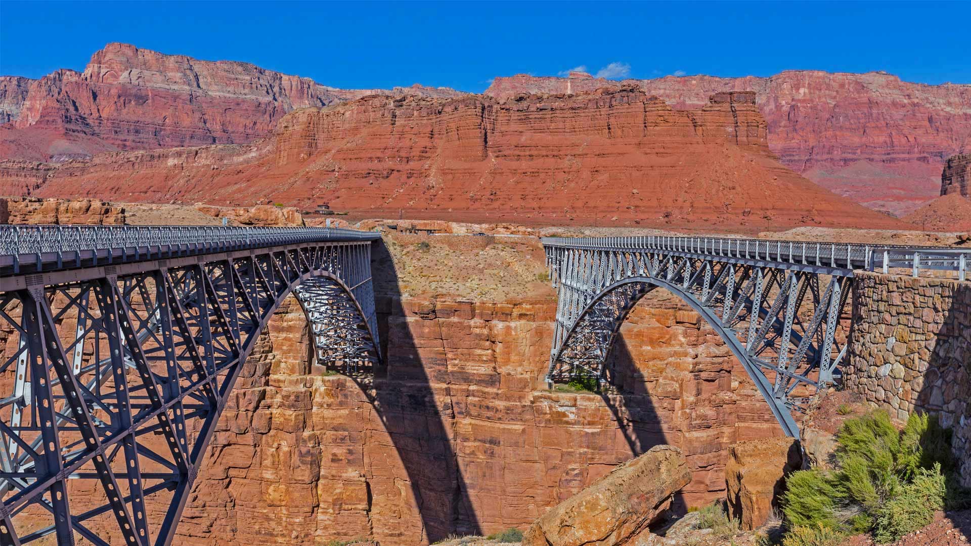
大理石峡谷中横跨科罗拉多河的纳瓦霍桥,美国亚利桑那州北部 Marble Canyon bridges over the Colorado River at the Glen Canyon National Recreation Area in northern Arizona (© trekandshoot/Alamy)
横跨峡谷裂缝的两座桥 Bridging the gap two ways
Happy birthday, bridges
Today we're taking a trip to a part of northern Arizona cut off from the rest of the state by the Colorado River and its deep canyons. No doubt you've heard of the Grand Canyon, but today is an important milestone to another canyon about 70 miles away. On this date in 1995, the twin Marble Canyon bridges, better known collectively as Navajo Bridge, were officially dedicated as the second bridge was installed.
The first, in place since 1929 when it was hailed as a 'modern marvel' and 'the biggest news in Southwest history,' had long been key to travel across the 834-foot gap of Marble Canyon. But as time passed, the area saw heavier vehicles and more traffic. After much debate about the impact on Native land and endangered plants, and the likelihood of debris falling into the river below, plans were developed for the $14.7 million, nearly identical second bridge. Now, Marble Canyon has two bridges, each about 470 feet over the Colorado River. The original serves as a path for humans and horses while the new bridge carries vehicles. Both bridges hold the title of ninth-highest in the United States (though the newer one is about three feet higher).
生日快乐,桥
今天,我们将前往亚利桑那州北部的一个地区,那里被科罗拉多河及其深峡谷与该州的其他地区隔绝。毫无疑问,你听说过大峡谷,但今天是70英里外另一个峡谷的重要里程碑。1995年的这一天,两座大理石峡谷大桥(合称纳瓦霍桥)正式投入使用,第二座大桥也安装完毕。
自1929年被誉为“现代奇迹”和“西南历史上最大的新闻”以来,第一条铁路一直是穿越834英尺高的大理石峡谷的关键。但随着时间的推移,该地区的车辆越来越重,交通也越来越多。在对当地土地和濒危植物的影响以及碎片落入河流的可能性进行了大量辩论后,为价值1470万美元、几乎相同的第二座桥梁制定了计划。现在,大理石峡谷有两座桥,每座桥跨越科罗拉多河约470英尺。最初的桥梁是人和马的通道,而新的桥梁则承载车辆。这两座桥都是美国第九高的桥梁(尽管较新的桥高约三英尺)。