萨拉纳克湖村,阿迪朗达克山脉,纽约州,美国 Village of Saranac Lake, Adirondack Mountains, New York (© DenisTangneyJr/Getty Images)
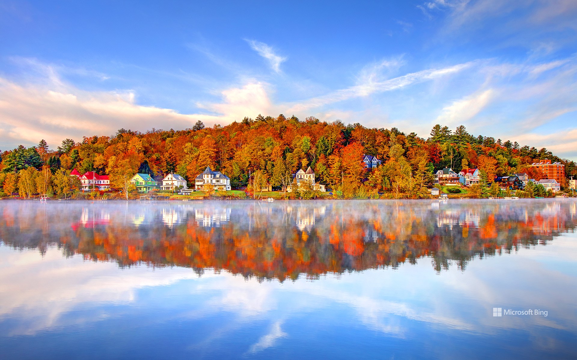
萨拉纳克湖村,阿迪朗达克山脉,纽约州,美国 Village of Saranac Lake, Adirondack Mountains, New York (© DenisTangneyJr/Getty Images)
爱上萨拉纳克 Falling for Saranac
萨拉纳克湖村,纽约州
有些地方只是地图上的一个点,但萨拉纳克湖却是一年四季都吸引游客的热门目的地。尽管名字里带“湖”,这个小镇并不直接坐落在萨拉纳克湖群边,而是位于萨拉纳克河的一段宽阔水域——弗劳尔湖畔。几个世纪以来,这片被称为“阿迪朗达克之都”的地方,一直是原住民狩猎和迁徙的要地。到19世纪末,这里因成为疗养胜地而声名鹊起,爱德华·李文斯顿·特鲁多医生在此开创了肺结核的新鲜空气疗法。那一时期的“疗养小屋”至今依然保存完好。
如今,萨拉纳克湖早已从治病救人转变为治愈无聊的好去处。游客们可以在水道上划桨,攀登高峰,冬天则能体验滑雪和冰钓的乐趣。村子里也同样充满艺术气息,画廊、音乐和社区节庆让文化与户外活动同样重要。本地的商店和餐馆更为旅程增添滋味,从新鲜鳟鱼到精酿啤酒应有尽有。每年举办的冬季嘉年华是最大亮点,其中的冰宫仿佛出自冰雪童话,足以证明这个小镇很懂得如何留下“酷”的印象——不论是氛围,还是温度。
Village of Saranac Lake, New York
Some places are just stops on the map, but Saranac Lake in New York's Adirondack Mountains is a destination that keeps people hooked year-round. Despite its name, this village isn't directly on the Saranac Lakes themselves but rather on Lake Flower, a wide section of the Saranac River. For centuries, the area—nicknamed 'The Capital of the Adirondacks'—was used by Indigenous peoples for hunting and travel. By the late 19th century, it gained fame as a health retreat, where Dr. Edward Livingston Trudeau pioneered fresh-air treatment for tuberculosis. The cure cottages from that era still stand today.
Today, Saranac Lake has shifted from curing patients to curing boredom. Visitors paddle the waterways, hike the High Peaks, and enjoy winter activities like skiing and ice fishing. The village also boasts a lively arts scene, with galleries, music, and community festivals making culture as central as the outdoors. Local shops and restaurants add flavor, serving everything from trout to craft beer. The annual Winter Carnival is a highlight, complete with an ice palace that looks like something out of a frosty fairy tale, proving this village knows how to make a cool impression—literally.
克拉克山脉, 内华达山脉, 约塞米蒂国家公园, 加利福尼亚州, 美国 Clark Range, Sierra Nevada, Yosemite National Park, California (© Robb Hirsch/TANDEM Stills + Motion)
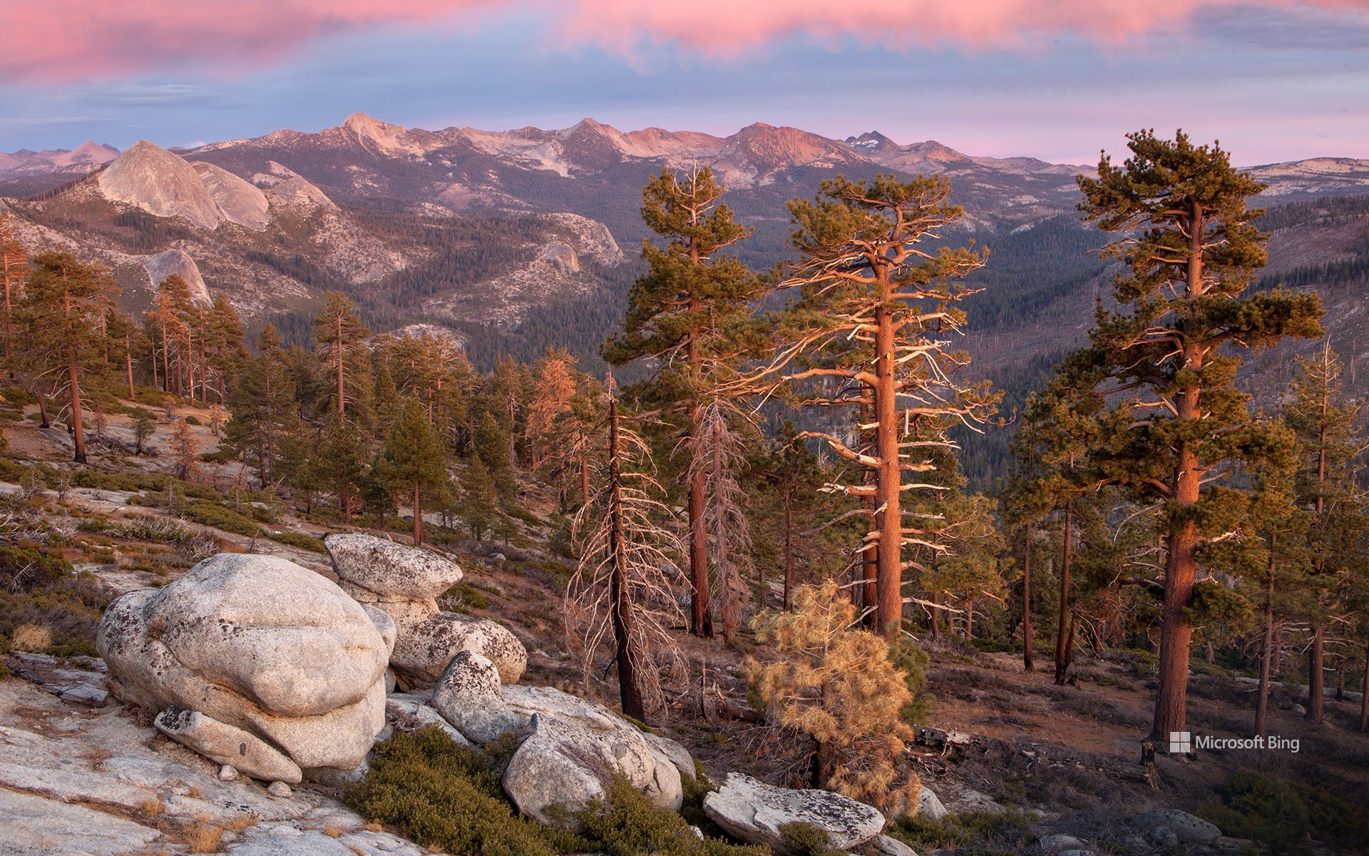
克拉克山脉, 内华达山脉, 约塞米蒂国家公园, 加利福尼亚州, 美国 Clark Range, Sierra Nevada, Yosemite National Park, California (© Robb Hirsch/TANDEM Stills + Motion)
克拉克山脉的回声 Echoes from the Clark Range
克拉克山脉, 约塞米蒂国家公园, 加利福尼亚州
今年是约塞米蒂国家公园遗产的又一个里程碑。约塞米蒂国家公园自1864年以来一直受到保护,以其令人惊叹的壮丽景色和生态意义而闻名。约塞米蒂坐落在内华达山脉的中心地带,占地近1200平方英里,孕育着巨大的花岗岩、奔腾的瀑布和古老的红杉。克拉克山脉是其鲜为人知的瑰宝之一——今天照片中显示的崎岖高海拔山脊。它以约塞米蒂的第一位守护者、自然保护先驱盖伦·克拉克的名字命名。
克拉克山脉静静地守护着约塞米蒂南部的荒野,其山峰被冰川侵蚀,顶部覆盖着高山草甸。这里,微风轻拂白皮松,天空开阔,呼应着公园诞生时的远见卓识。
Clark Range, Yosemite National Park, California
This year marks another milestone in the legacy of Yosemite National Park, a sanctuary protected since 1864 and celebrated for its awe-inspiring grandeur and ecological significance. Nestled in the heart of the Sierra Nevada, Yosemite's nearly 1,200 square miles cradle granite giants, cascading waterfalls, and ancient sequoias. Among its lesser-known treasures lies the Clark Range—the rugged, high-elevation spine seen in today's image. It was named after Galen Clark, Yosemite's first guardian and a pioneer of conservation.
The Clark Range stands as a quiet sentinel to Yosemite's southern wilderness, its peaks etched by glaciers and crowned with alpine meadows. Here, the wind whispers through whitebark pines and the sky opens wide, echoing the spirit of foresight that birthed the park.
As we honor Yosemite's anniversary, we celebrate not only its grandeur but the enduring vision of those who fought to preserve it. From the valley's granite walls to the Clark Range's serene heights, this national park remains a living poem—written in stone, water, and time.
塞切达,多洛米蒂山脉的山峰,南蒂罗尔,意大利 Seceda, a peak in the Dolomites, South Tyrol, Italy (© Kalyakan/Adobe Stock)
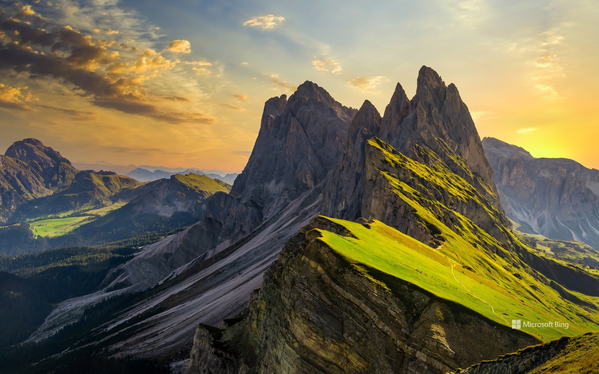
塞切达,多洛米蒂山脉的山峰,南蒂罗尔,意大利 Seceda, a peak in the Dolomites, South Tyrol, Italy (© Kalyakan/Adobe Stock)
锋芒毕露的美 Beauty with an edge
塞切达,多洛米蒂山脉的山峰,南蒂罗尔,意大利
意大利多洛米蒂山脉不仅雄伟耸立,更如施展魔法般,使每一条山路都变成一个故事。人们亲切地称它们为“苍白山脉”,这一名字源自其主要构成矿物白云石。这片山脉坐落于意大利北部阿尔卑斯山脉,占地超过34.5万英亩,拥有18座海拔超过9,500英尺的高峰。其地貌特征包括陡峭的悬崖、雄伟的岩壁和蜿蜒狭窄的山谷。
在多洛米蒂山的壮丽景色之中,坐落着其最壮观的山峰之一塞切达,正是今日图中所示。它海拔约8200英尺,是南蒂罗尔省瓦尔加迪纳山谷中最高的全景观景台。乘坐缆车即可轻松抵达山顶,省去原本艰难的登山行程。登顶之后,映入眼帘的是多洛米蒂山标志性的锯齿状山脊线的壮丽全景。在晴朗的日子里,甚至可以远眺90多英里外的奥地利最高峰格洛克纳山。
Seceda, Dolomites, South Tyrol, Italy
Italy's Dolomites don't just tower; they enchant, turning every trail into a story. Fondly known as the 'Pale Mountains,' the Dolomites derive their name from dolomite—a carbonate mineral. Set in the northern Italian Alps, the range spans over 345,000 acres and boasts 18 soaring peaks that rise above 9,500 feet. These mountains feature sheer cliffs, lofty walls, and a maze of narrow, winding valleys.
Amid the dramatic landscape of the Dolomites lies one of its most spectacular peaks, Seceda, featured in today's image. With a height of around 8,200 feet, it offers the highest panoramic viewpoint in Val Gardena, a scenic valley in the province of South Tyrol. A short cable car ride takes you to the summit, bypassing what would otherwise be a strenuous hike. Once at the top, you're greeted by a stunning sweep of the Dolomites' iconic jagged ridgelines. On a clear day, you might even spot Austria's tallest mountain, the Großglockner, located more than 90 miles away.
五塔峰,多洛米蒂山脉,科尔蒂纳丹佩佐,贝卢诺省,意大利威尼托大区 Cinque Torri, Dolomites, Italy (© usabin/Getty Images)
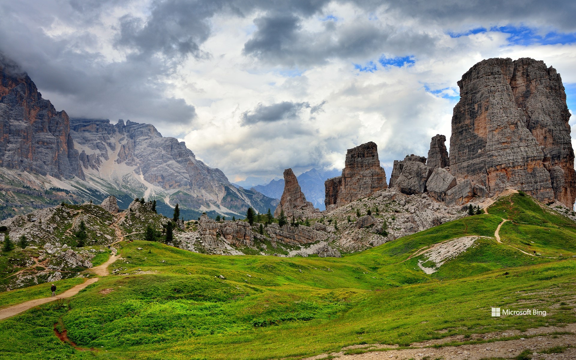
五塔峰,多洛米蒂山脉,科尔蒂纳丹佩佐,贝卢诺省,意大利威尼托大区 Cinque Torri, Dolomites, Italy (© usabin/Getty Images)
静谧之声 The sounds of quiet
多洛米蒂山脉五塔峰,意大利
五塔峰坐落于意大利威尼托大区贝卢诺省的多洛米蒂山脉腹地,仿佛天然雕塑般矗立,是夏季避暑、远离海滩与城市喧嚣的理想之选。每一座岩塔皆承载着独特的历史与自然故事:从古文明的遗迹,到徒步与登山者的足迹,再到第一次世界大战时期的军事要地。这些塔峰在战时曾扮演战略要塞的角色,如今游客仍可探访战壕遗址与战争留下的痕迹。然而,自然的力量终将超越人类历史:茂密松林、芳草牧场与山间溪流共同构成了一幅宁静和谐的生态图景,晴朗的天空与繁花草甸相映成趣,伴随着阵阵鸟鸣,为前行的每一步增添生机。
漫步在五塔之间,便是呼吸自由与新鲜空气,在群山静谧中倾听内心。无论你是在攀登、拍照,还是静静沉思,这个地方为游客提供了一个重新发现自我与自然联系的契机。在这里,时间仿佛放慢了脚步,灵魂得以舒展,而自然之美则以沉稳而恒久的姿态,讲述着群山间的故事。
奇索斯山脉,大弯国家公园,德克萨斯州,美国 Chisos Mountains, Big Bend National Park, Texas (© Dean Fikar/Getty Images)
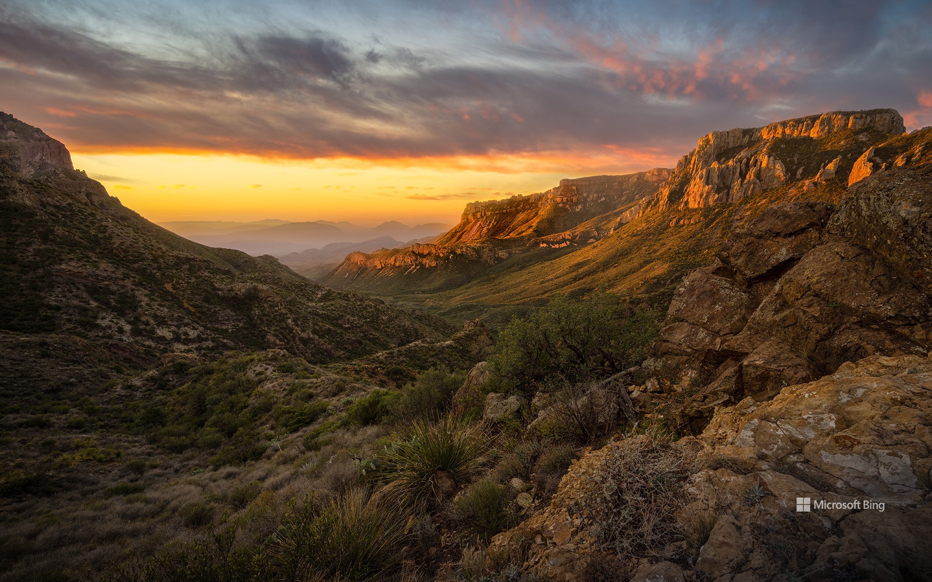
奇索斯山脉,大弯国家公园,德克萨斯州,美国 Chisos Mountains, Big Bend National Park, Texas (© Dean Fikar/Getty Images)
星空、岩石与孤寂 Stars, stone, and solitude
大弯国家公园迎来81周年
人们常说:“德州的一切都更大。”而大弯国家公园正是对这句话的最佳注解。这片占地801,163英亩的广袤区域,最初属于墨西哥领土,1848年并入美国。自20世纪30年代起,该地区的自然景观便受到保护,并于1944年6月12日正式被指定为国家公园。大弯国家公园是美国最偏远、游客最少的国家公园之一。它并非由单一地貌构成,而是三种景观的综合体:奇瓦瓦沙漠、奇索斯山脉和格兰德河。公园地处美墨边境,其历史也体现出文化交融的特征:原住民、西班牙探险者、牧场主、矿工和游客皆曾在此留下足迹。岩画、历史遗迹和古道见证了这片土地在成为国家公园之前就已拥有深厚历史。
公园内生物多样性极为丰富,记录有超过1,200种植物、超过450种鸟类,以及多种哺乳动物、爬行动物和两栖动物。你可能会看到一只走鹃迅速穿越沙尘,或是一只山猫悄然穿行于灌木之间。此外,大弯国家公园也被评为美国最佳暗夜公园之一。游客在此可观赏到银河、行星和满天繁星构成的璀璨星空。
Big Bend National Park in Texas turns 81
They say everything's bigger in Texas—and Big Bend National Park has been living up to the slogan since forever. Efforts to preserve this 801,163-acre area of West Texas began in the 1930s and culminated in its official designation as a park on June 12, 1944. Big Bend remains one of the most remote and least-visited national parks in the country. It's not just one landscape, it's three: the Chihuahuan Desert, the Chisos Mountains (pictured here), and the Rio Grande. Big Bend sits on the US–Mexico border, and its history reflects that blend. Indigenous peoples, Spanish explorers, ranchers, miners, and modern travelers have all left their footprints. Petroglyphs, ruins, and old trails show the land's story began long before it became a park.
The park is home to over 1,200 species of plants, more than 450 species of birds, and a wide variety of mammals, reptiles, and amphibians. You might spot a roadrunner zipping across the dirt, or a bobcat silently slipping through the underbrush. Additionally, it has been designated as one of the best dark-sky parks in America, offering views of the Milky Way, planets, and constellations.
Coll d'Ares,加泰罗尼亚比利牛斯山脉 Coll d'Ares, Catalan Pyrenees (© CRISTIAN IONUT ZAHARIA/Shutterstock)
Coll d'Ares,加泰罗尼亚比利牛斯山脉 Coll d'Ares, Catalan Pyrenees (© CRISTIAN IONUT ZAHARIA/Shutterstock)
Coll d'Ares,加泰罗尼亚比利牛斯山脉
阿雷斯山口位于海拔1,512米,是穿越雄伟比利牛斯山脉、连接西班牙和法国的山间通道。山口位于加泰罗尼亚里波列斯地区的莫洛与法国奥克西塔尼亚的普拉茨德莫洛拉普雷斯特之间。冬季,这里白雪皑皑,景色令人叹为观止。
阿雷斯山口的历史可追溯至878年,不仅是一条地理通道,更是连接文化与历史的桥梁。其名称源自拉丁语‘ara’,意为祭坛,唤起了古代用神圣石碑标记边界的记忆。在九年战争期间,这里曾是重要军事行动的舞台。
如今,阿雷斯山口已成为探索自然的独特目的地。无论是徒步旅行、欣赏全景风光,还是探索丰富的历史,阿雷斯山口都能让游客流连忘返。在此感受比利牛斯山脉的清新空气,尽情沉浸于这片神奇的土地中吧!
艾纳, 塞古拉山脉, 阿尔瓦塞特, 西班牙 Ayna, Sierra del Segura, Albacete, Spain (© Juan Maria Coy Vergara/Getty Images)
艾纳, 塞古拉山脉, 阿尔瓦塞特, 西班牙 Ayna, Sierra del Segura, Albacete, Spain (© Juan Maria Coy Vergara/Getty Images)
西班牙的小瑞士 Spain's little Switzerland
艾纳,阿尔瓦塞特, 西班牙
说起西班牙,你脑海中首先浮现的可能不是雪,但从高耸入云的山峰到阳光温暖的海滩,西班牙拥有各种地貌。图片中的小村庄艾纳坐落于由蒙多河冲刷而成的陡峭山谷中,周围环绕着塞古拉山脉,人口不足1000人。冬季,这里白雪皑皑,因此人们常把这个小镇称为 “曼切根瑞士”。而这个名称中的“曼切根”则指的是艾纳所属的卡斯蒂利亚-拉曼恰自治区。艾纳距离西班牙首都马德里以南约150英里,是西班牙乡村生活的独特一瞥。
Aýna, Albacete, Spain
Welcome to the tiny Spanish village of Aýna, in a steep valley carved by the River Mundo in the Sierra del Segura range. This part of the Castile-La Mancha region is sometimes called Manchegan Switzerland, thanks to those snow-capped peaks during the winter months. The steep, rocky terrain here means the villagers, of whom there are less than 1,000, cultivate the land on terraces dug into the mountainside. To see Aýna from this perspective, you'll need to visit the Mirador del Diablo, or Devil's Viewpoint, one of several viewing areas dotted around this picturesque valley.
阿尔卑斯山脉锡尔夫雷塔山的乔里森湖,瑞士 Jöriseen lakes in the Silvretta Alps, Switzerland (© Florin Baumann/Getty Images)
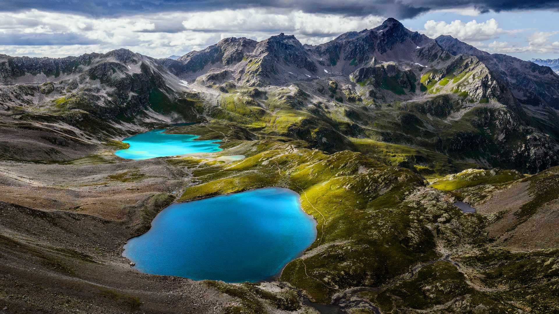
阿尔卑斯山脉锡尔夫雷塔山的乔里森湖,瑞士 Jöriseen lakes in the Silvretta Alps, Switzerland (© Florin Baumann/Getty Images)
蓝湖和险峰 Bright blue lakes and rugged mountains
阿尔卑斯山脉锡尔夫雷塔山的约里森湖,瑞士
今天我们要探索一处超凡脱俗的奇景:瑞士达沃斯附近的约里森湖群。天气晴朗时,湖面会呈现出不真实的蓝色,和周围灰暗、嶙峋的锡尔夫雷塔山形成鲜明的对比。阳光被水中的“岩粉”(湖床被冰川摩擦产生的细微的岩石颗粒)反射,形成了这种鲜艳的蓝色。锡尔夫雷塔山被冰川环绕,和碧蓝色的约里森湖一起被称为“蓝色锡尔夫雷塔”。如果你想亲眼目睹此景,要知道来到此地的路途并不容易。记得带上合适的徒步鞋、大量的饮用水和强健的双腿。
Jöriseen lakes in the Silvretta Alps, Switzerland
Today we're exploring a place of otherworldly beauty: the Jöriseen, a group of alpine lakes near Davos, Switzerland. On sunny days, the lakes glow an ethereal blue, contrasting with the dark, jagged Silvretta Alps that encircle them. The sunlight is reflected in the water by 'rock flour'—silt-sized rock particles generated from the grinding of bedrock by glaciers.
The Silvretta Alps sit across the Swiss-Austrian border and are themselves surrounded by glaciers in an area known as the 'Blue Silvretta.' If you want to enjoy these stunning views up close, you'll have to work for it. Bring your best hiking boots, plenty of water, and some strong legs.
菲希特尔山脉上的和平钟,萨克森州,德国 Peace bell on the summit of Fichtelberg, Saxony, Germany (© Jan Drahokoupil/Getty Images)
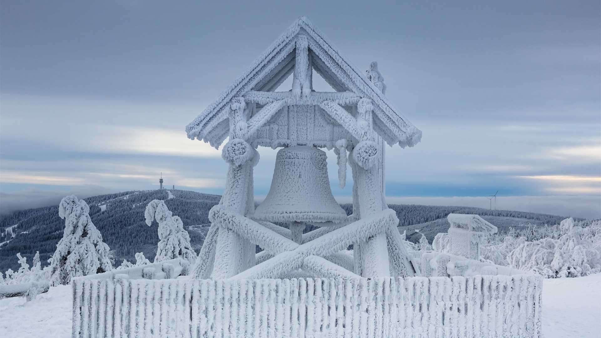
菲希特尔山脉上的和平钟,萨克森州,德国 Peace bell on the summit of Fichtelberg, Saxony, Germany (© Jan Drahokoupil/Getty Images)
和平之钟 A bell for peace
菲希特尔山脉,德国萨克森州
菲希特尔山位于厄尔士山脉的上维森塔尔镇附近。这座山高1214米,是东德最高的山峰,也是冬季运动爱好者的圣地。这里有各种冬季运动,双板滑雪、单板滑雪、越野滑雪、雪橇雪橇和马拉雪橇等等。如果你更喜欢夏天,也可以在这里来场夏日旅行,体验这里的自然风景。在菲希特尔山顶有一座和平钟,在这里欣赏到周围群山的壮丽景色。
Peace bell on Fichtelberg, Germany
The Fichtelberg is located on the Oberwiesenthal in the Ore Mountains. This mountain is 1214 m high, making it not only the highest mountain in East Germany but also a very prestigious place for winter sports enthusiasts. All kinds of sports are offered. From classic skiing and snowboarding to cross-country skiing, cross-country skiing tours, tobogganing, and horse-drawn sleigh rides. If you prefer summer, you can also enjoy this place in the warm season and completely immerse yourself in untouched nature. At the top of the mountain, you can visit the Fichtelberghaus. From there you have a breathtaking view of the surrounding mountains.
多洛米蒂山脉安特莫亚湖上的日晕,意大利 Sun halo over Lake Antermoia in the Dolomite Mountains of Italy (© Walter Donega/Getty Images)
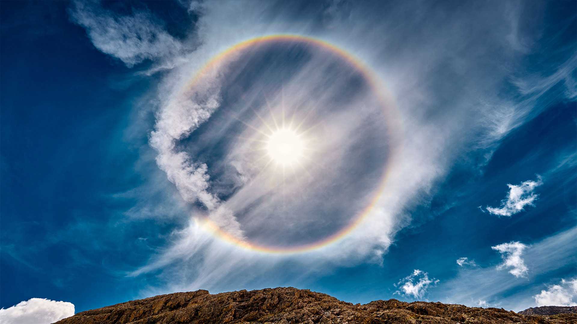
多洛米蒂山脉安特莫亚湖上的日晕,意大利 Sun halo over Lake Antermoia in the Dolomite Mountains of Italy (© Walter Donega/Getty Images)
环绕太阳的彩虹 Rainbow around the sun
意大利安特莫亚湖上空的太阳晕
从这里开始,日子只会变长!北半球今天标志着冬天的开始,但冬至也是一年中最短的一天。这里环绕太阳的彩虹,一个太阳光环,位于意大利北部多洛米特山脉的安特摩亚湖上方。当太阳或月亮的光线穿过悬浮在上层大气中的冰晶时,就会形成太阳晕。当太阳光照射到晶体上时,它们就充当了一个棱镜,将光分成光谱中的不同颜色,就像暴雨后彩虹出现的方式一样。
Sun halo over Lake Antermoia, Italy
The days only get longer from here! The Northern Hemisphere marks the beginning of winter today, but the winter solstice is also the shortest day of the year. The rainbow that encircles the sun here, a sun halo, is above Lake Antermoia, in the Dolomite Mountains of northern Italy. Sun halos form when sun or moon light shines through ice crystals suspended in the upper atmosphere. When the light of the sun hits the crystals they serve as a prism, separating the light into individual colors of the spectrum, the same way rainbows occur after a rain shower.