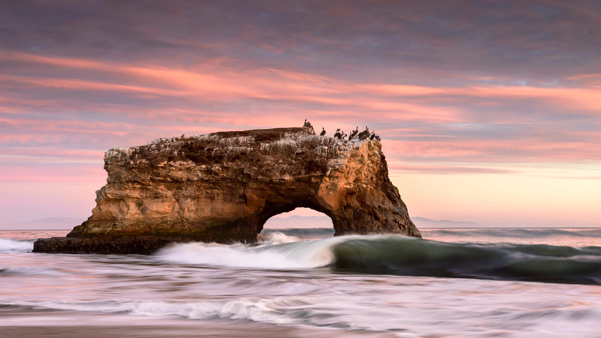
加利福尼亚州圣克鲁斯的天然桥州立公园 Natural Bridges State Beach in Santa Cruz, California (© Jim Patterson/Tandem Stills + Motion)
加利福尼亚州圣克鲁斯的天然桥州立公园 Natural Bridges State Beach in Santa Cruz, California (© Jim Patterson/Tandem Stills + Motion)
通往太平洋之窗 A window to the Pacific
天然桥州立公园,加利福尼亚州,美国
天然桥州立公园位于美国加利福尼亚州的圣克鲁斯市。初期,这里有三座海水侵蚀而成的拱桥,其中一座于1905年倒塌,后来又有一座于1980年倒塌,剩下我们如今看到的这座拱桥。然而,海浪的侵蚀是无情的,因此仅剩的这座拱桥最终也会倒塌。除了拱桥,这个公园还有君主斑蝶,因此也吸引了不少游客。
Natural Bridges State Beach in Santa Cruz, California
California brown pelicans, cormorants, and gulls enjoy jostling for position on top of this stunning rock formation in Natural Bridges State Beach in Santa Cruz. It is the sole surviving natural 'bridge' in this state park. Once three bridges stood side-by-side here, carved by waves into cliffs that jutted out into the Pacific. This one stood in the middle, but the outermost bridge collapsed in 1905 and the innermost one disappeared in 1980.
The erosion of the waves is relentless, so eventually the final arch will collapse, and the birds will have to find another favorite perch. But there are plenty of other views on offer. The park is also a seasonal home to migratory monarch butterflies, which flutter through the air or cluster together in its eucalyptus grove. And if you're lucky, you might spot a migrating whale or see seals and otters playing offshore.
约书亚树国家公园上空的银河,美国加利福尼亚州 Milky Way over Joshua Tree National Park, California (© Schroptschop/Getty Images)
约书亚树国家公园上空的银河,美国加利福尼亚州 Milky Way over Joshua Tree National Park, California (© Schroptschop/Getty Images)
沙漠上空的星海 An ocean of stars above the desert
国际天文
今天是天文日,快准备好望远镜和星图APP去观星吧!为了让更多人对太空感兴趣,道格·伯杰于1973年创立了天文日,他在街角、商场和公园里架设了望远镜,让人们有机会亲眼看到星星。
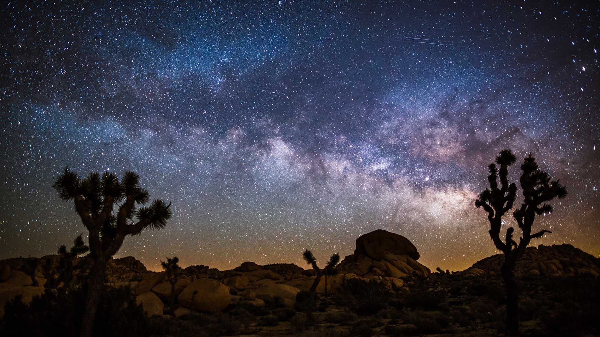
早期的天文学家缺乏工具,只能凭肉眼观测天体,但他们仍然取得了重大的成就,例如计算月球的大小和距离,确认太阳是太阳系的中心,以及预测恒星运动和地球季节的关系。如今,我们拥有各种先进的望远镜,有詹姆斯韦伯太空望远镜,也有便携式望远镜,在国际黑暗天空公园里你都能看到有人在用这些先进的设备观星。
Astronomy Day
Get your telescope and star map app ready because it's Astronomy Day! Doug Berger, then president of the Astronomical Association of Northern California, created Astronomy Day in 1973 to get more people interested in the wonders of space. He set up telescopes on street corners, malls, and parks to give people a chance to see the stars firsthand.
Early astronomers lacked the means to view celestial objects beyond those which could be seen by the naked eye. But they still made major discoveries, such as calculating the size and distance of the moon, affirming the sun as the center of our solar system, and predicting the movement of stars relative to the seasons. Today we have sophisticated telescopes, from the orbiting James Webb Space Telescope to the portable ones you'll find in use at International Dark Sky Parks, including Joshua Tree National Park, seen in our photo. With such ground-breaking technology at our disposal, astronomers can boldly go where no human eyes have gone before.
优胜美地国家公园的马里波萨谷巨杉林,美国加利福尼亚州 Mariposa Grove in Yosemite National Park, California (© Orbon Alija/Getty Images)
优胜美地国家公园的马里波萨谷巨杉林,美国加利福尼亚州 Mariposa Grove in Yosemite National Park, California (© Orbon Alija/Getty Images)
温暖的阳光穿过古老森林 Warm light through an ancient forest
马里波萨谷巨杉林
四月的最后一个星期五是美国的植树节,这一天,人们会庆祝植树成果、倡导保护树木。植树节最早起源于19世纪70年代初的内布拉斯加州,1872年,就职于《内布拉斯加州城市新闻》的记者朱利叶斯·斯特林·莫顿(Julius
Sterling Morton)在公共平台上发起了美国第一个植树节,并提议为内布拉斯加州人民设立一个种树日,于是植树节应运而生。
Arbor Day
We're celebrating Arbor Day with some of Yosemite's most famous residents, the giant sequoia trees of Mariposa Grove. The day champions the planting and preservation of trees and can trace its roots back more than 150 years. In 1872, Nebraska City News editor Julius Sterling Morton proposed a day for locals to plant trees, and the idea grew and grew. Today all 50 states celebrate Arbor Day, most commonly on the last Friday in April, although different states might observe it on the best dates for tree planting in their area.
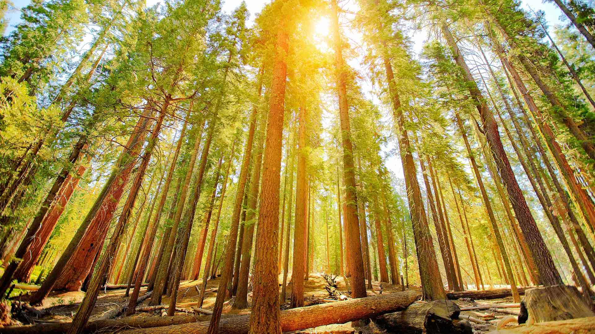
Giant sequoias, like the ones on our homepage, have been around for a very long time. Geological evidence suggests that they are the third-longest-lived tree species in the world. There are hundreds of them in Yosemite's Mariposa Grove, including the famous Grizzly Giant, which is estimated to be about 3,000 years old. Let's hope it is around for thousands of Arbor Days to come.
安沙波利哥沙漠州立公园的野花,加利福尼亚州,美国 Wildflowers in Anza-Borrego Desert State Park, California (© Ron and Patty Thomas/Getty Images)
安沙波利哥沙漠州立公园的野花,加利福尼亚州,美国 Wildflowers in Anza-Borrego Desert State Park, California (© Ron and Patty Thomas/Getty Images)
大自然最为色彩鲜艳的一面 Nature at its colorful best
安沙波利哥沙漠州立公园,加利福尼亚州,美国
欢迎来到美国加州最大的沙漠州立公园——安沙波利哥。这个公园以烂漫春花和自然奇观而闻名。初夏是游览的最佳时节,漫山遍野都是各种野花、植物和仙人掌。这些野花为原本贫瘠的沙漠景观增添了色彩,吸引大批游客的到来。尽管你可能会想摘一些回家,但野花受到加州法律的保护,再说美景也不应私藏,而应大家共赏。
Anza-Borrego Desert State Park, California
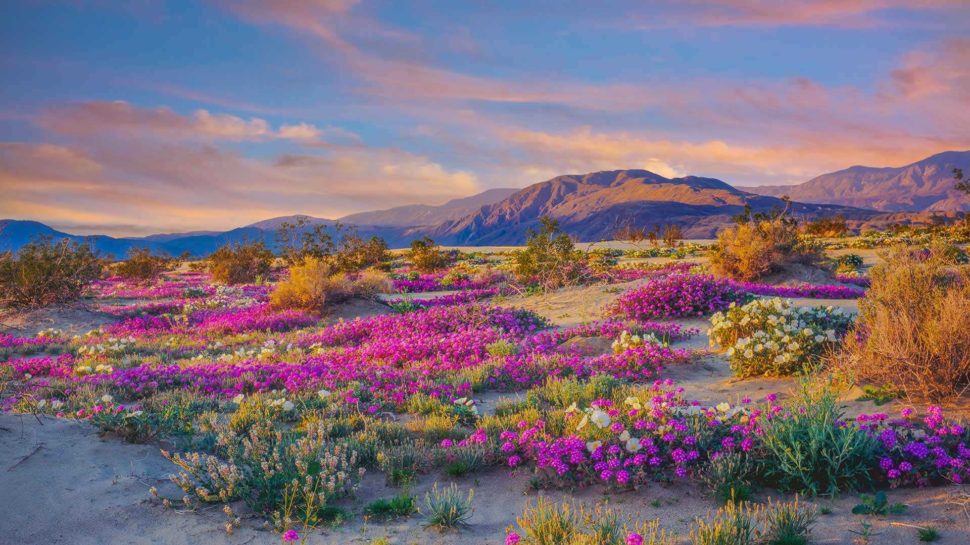
Welcome to the largest state park in the golden state of California, Anza-Borrego. Located about 100 miles northeast of San Diego, the park is well known for its spectacular springtime wildflowers, stunning landscapes, and natural marvels. Spring and early summer are the best times to visit. That's when you'll find a myriad of magnificent, blooming species of flowers, including dune primrose, desert sunflowers, and desert sand verbena. These hardy wildflowers can survive in extreme heat and with little water–perfect for California's driest state park, in which some areas get just 2 inches of rain a year.
Heavier rains than usual brought a rare 'winter bloom' of wildflowers to Anza-Borrego earlier this year. And record-breaking rainstorms have continued, ensuring an excellent spring display. The wildflowers draw large crowds of tourists to the area. Though you might be tempted to take some home, the wildflowers are protected by state law and should be left for everyone to enjoy.
“火流”马尾瀑布,约塞米蒂国家公园,美国加利福尼亚州 'Firefall' on Horsetail Fall, Yosemite National Park, California (© Jeff Lewis/Tandem Stills + Motion)
“火流”马尾瀑布,约塞米蒂国家公园,美国加利福尼亚州 'Firefall' on Horsetail Fall, Yosemite National Park, California (© Jeff Lewis/Tandem Stills + Motion)
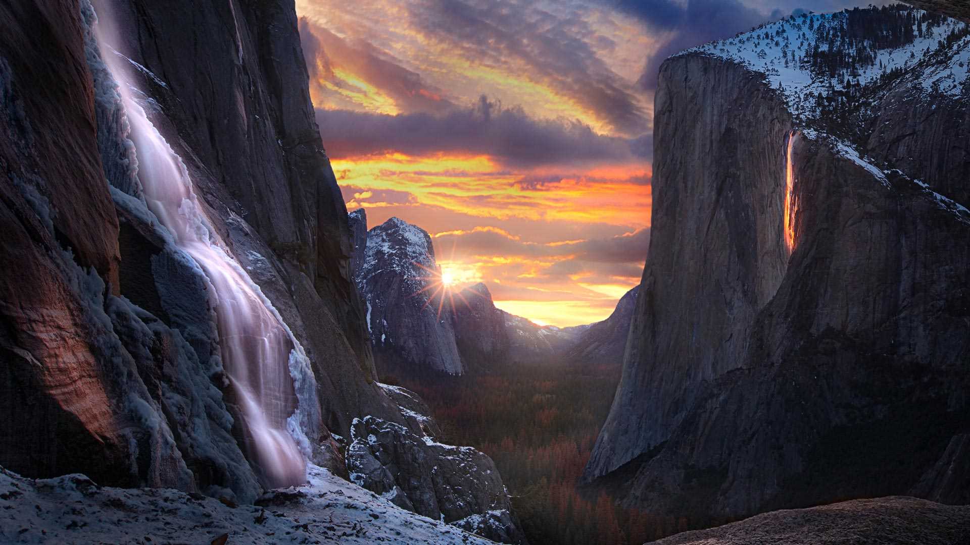
这个悬崖怎么着火了? Why is this cliffside ablaze?
马尾瀑布,约塞米蒂国家公园,加利福尼亚州
在约塞米蒂国家公园的埃尔卡皮坦山东侧,当所有自然条件齐备,马尾瀑布就像火一样“燃烧”起来。这种现象只有在2月的几周时间里可以看到,前提是天气晴朗,雪水或雨水形成瀑布,并且光照条件恰到好处。“火瀑布”只会持续大约10分钟,届时,观景区会人潮涌动。希望今年的游客能有幸看到这一神奇的自然景观。
Horsetail Fall, Yosemite National Park, California
When nature converges in rare and glorious fashion on the east side of the rock formation known as El Capitan, Horsetail Fall is illuminated as if on fire. This phenomenon can only be seen for a couple of weeks in February if there is a clear sky, enough water flowing from snowmelt or rain, and perfect timing. This 'firefall' only lasts for around 10 minutes and vantage points can be crowded. Horsetail Fall and El Capitan are part of Yosemite National Park, the second-oldest national park in the US. We hope this year's visitors are fortunate enough to see this magical display.
死亡谷扎布里斯基角上空的银河,美国加利福尼亚州 The Milky Way over Zabriskie Point, Death Valley, California (© Matt Anderson Photography/Getty Images)
死亡谷扎布里斯基角上空的银河,美国加利福尼亚州 The Milky Way over Zabriskie Point, Death Valley, California (© Matt Anderson Photography/Getty Images)
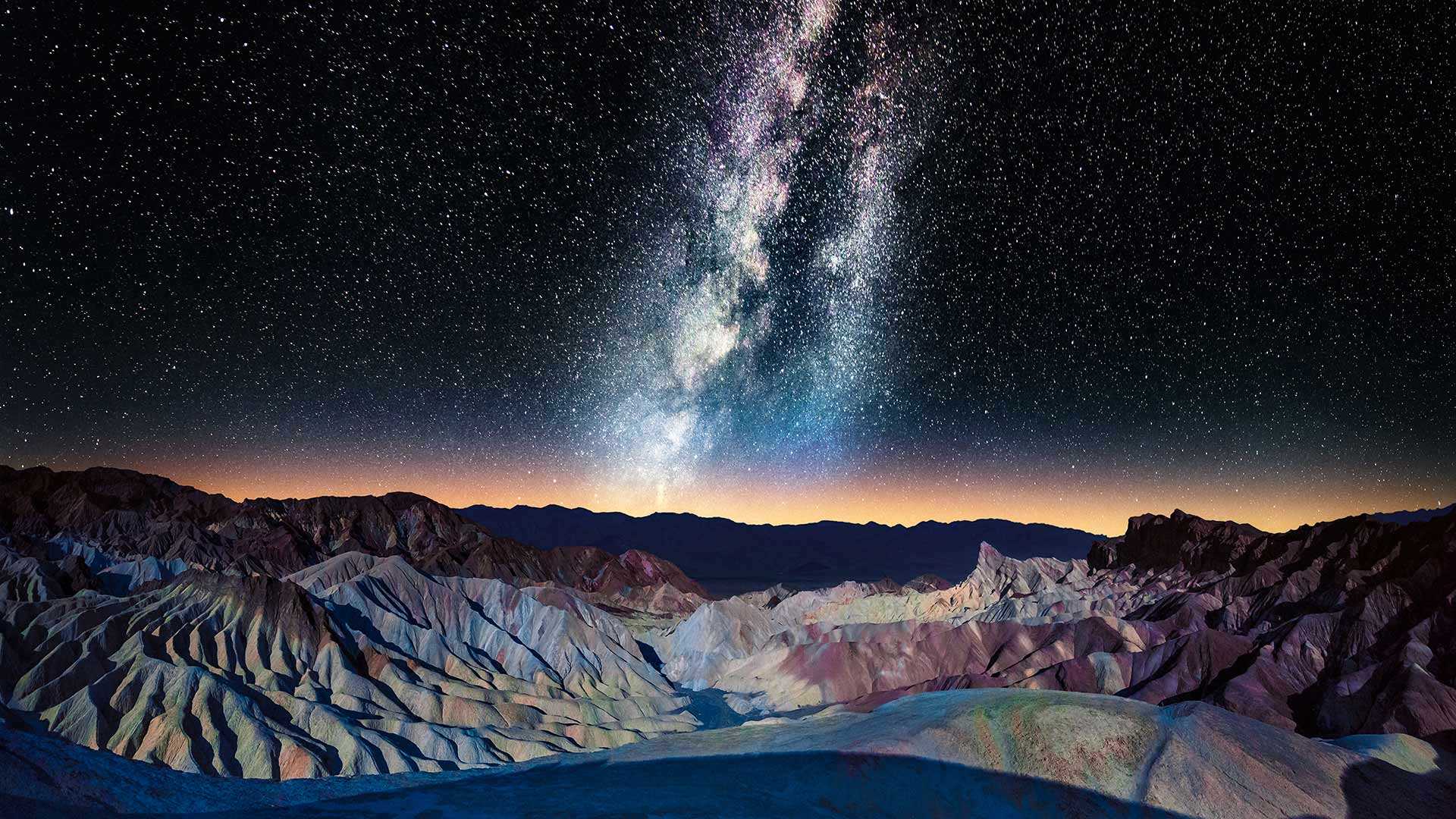
布满星星的天空 A sky full of stars
扎布里斯基角上空的银河,加利福尼亚州
扎布里斯基角的标志性景观是摄影师和游客一年四季蜂拥而至的原因之一。大自然在这些荒地上侵蚀了亿万年,形成了这片令人惊叹的条纹岩层。这几座山峰上的深色部分是由古代火山爆发的熔岩形成的。扎布里斯基角位于加利福尼亚州的死亡谷国家公园,是无数电影(如《斯巴达克斯》和《星球大战》)的取景地。爱尔兰摇滚乐队U2的音乐专辑《约书亚树》的封面也在这里取景。难怪死亡谷暗夜节在美国如此受欢迎。
Milky Way over Zabriskie Point, California
The iconic view from Zabriskie Point is one of the reasons why photographers and tourists flock to this spot all year round. Weather and water carved out these badlands for eons, resulting in this stunning striped rock formation with an array of colors. The darker material on several peaks was formed by lava of an ancient volcanic eruption, making some of these ridges higher than others. Nestled in Death Valley National Park, California, Zabriskie Point has been the backdrop of countless movies like 'Spartacus' and 'Stars Wars.' The scenic overlook is featured on the cover of Irish rock band U2's album, 'The Joshua Tree.' It's no wonder the Death Valley Dark Skies Festival is a hugely popular event. Zabriskie Point was named after Christian Zabriskie, a distinguished member of the Pacific Coast Borax Company from 1885 to 1933.
新娘面纱瀑布, 优胜美地国家公园, 加利福尼亚州 Bridalveil Fall, Yosemite National Park, California (© Jeff Foott/Minden Pictures)
约书亚树,加利福尼亚州约书亚树国家公园 Joshua trees in Joshua Tree National Park, California (© Tim Fitzharris/Minden Pictures)
约书亚树,加利福尼亚州约书亚树国家公园 Joshua trees in Joshua Tree National Park, California (© Tim Fitzharris/Minden Pictures)
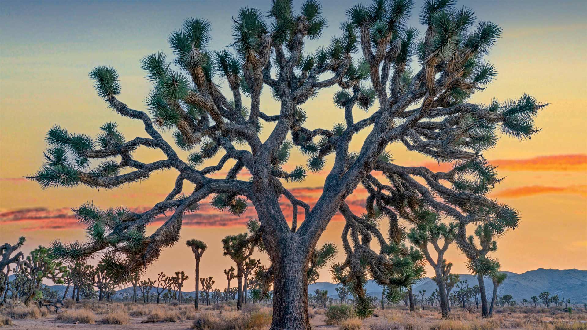
沙漠中的匕首? Desert daggers?
Joshua Tree National Park
These immensely photogenic and relatable trees, their shaggy, sinewy limbs thrust upward into the pale light of the desert sky, are the main reason people come here to California's Joshua Tree National Park. Joshua Tree was declared a national monument on August 10, 1936, before being designated a national park in 1994. Perhaps no other national park is so completely defined by a single feature, be it a plant or wildlife or natural formation. While Joshua Tree National Park contains other wonders, this tree that looks drawn by Dr. Seuss is what visitors come to celebrate.
The park (and the town of the same name) could also be called the hippest national park in the country, owing to its proximity to Los Angeles, and the Insta-worthy, charismatic flora that have helped make JT a darling on social media. Van lifers, artists, celebrities, and other creative bohemians have fueled a boom in tourism, not just to the park itself, but to the surrounding towns, like Pioneertown. The kitschy outpost served as an old Hollywood set and is now a center of nightlife in the area. Pappy & Harriet's Pioneertown Palace serves artisanal cocktails with its barbecue and features live music, sometimes from the likes of Paul McCartney, Robert Plant, and Patti Smith. And if you can't find an elderflower martini in Joshua Tree, then Palm Springs and Indio and Coachella are a short drive away, something Yellowstone and Yosemite can't claim.
But for those going purely for the nature—the hikers, rock climbers, campers, and stargazers—the 1,200-square-mile park is no less a marvel. Two deserts, the high-elevation Mojave and the low-elevation Colorado, merge here, each with its own ecosystem. The Joshua tree itself grows only on the Mojave side, at elevations between 1,300 and 5,900 feet. Most of the world's Joshua trees are found here. A variety of yucca, Joshua trees live to be 500 and 1,000 years old with roots as deep as 35 feet. Most believe their name was first concocted by Mormon pioneers who likened their branches to the oustretched arms of the biblical Joshua. It proved catchier than its botanical name, Yucca brevifolia. And as any influencer worth their followers will tell you, it makes for a much more memorable hashtag.
约书亚树国家公园
这些非常上镜且相互关联的树木,它们粗壮有力的四肢伸向沙漠天空的暗淡光线,是人们来到加利福尼亚州约书亚树国家公园的主要原因。约书亚树于1936年8月10日被宣布为国家纪念碑,然后于1994年被指定为国家公园。也许没有其他国家公园如此完全由单一特征来定义,无论是植物、野生动物还是自然形成物。约书亚树国家公园还有其他的奇观,这棵树看起来是苏斯博士画的,是游客们来庆祝的。
这个公园(和同名的小镇)也可以被称为美国最时髦的国家公园,因为它靠近洛杉矶,以及有魅力的植物群,使JT成为社交媒体上的宠儿。范利弗、艺术家、名人和其他富有创意的波西米亚人推动了旅游业的繁荣,不仅是公园本身,还有周边城镇,如先锋镇。这个俗气的前哨站曾经是好莱坞的老片场,现在是该地区的夜生活中心。Pappy&Harriet的先锋城宫殿提供手工鸡尾酒和烧烤,并配有现场音乐,有时来自保罗·麦卡特尼(Paul McCartney)、罗伯特·普兰特(Robert Plant)和帕蒂·史密斯(Patti Smith)。如果你在约书亚树上找不到接骨木花马提尼酒,那幺棕榈泉、Indio和Coachella就在很短的车程之外,这是黄石公园和约塞米蒂不能宣称的。
但对于那些纯粹为了大自然而去的徒步旅行者、攀岩者、露营者和观星者来说,1200平方英里的公园同样是一个奇迹。两个沙漠,高海拔的莫哈韦和低海拔的科罗拉多,在这里汇合,每个沙漠都有自己的生态系统。约书亚树本身只生长在莫哈韦一侧,海拔在1300到5900英尺之间。世界上大多数约书亚树都在这里找到。各种各样的丝兰树、约书亚树的树龄分别为500年和1000年,树根深达35英尺。大多数人相信他们的名字是摩门教先驱们首先炮制出来的,他们把他们的树枝比作圣经中约书亚被驱逐的手臂。事实证明,它比其植物学名称短叶丝兰更吸引人。任何有影响力的追随者都会告诉你,这是一个更令人难忘的标签。
被翡翠湾环绕的芬尼特岛,太浩湖,加利福尼亚 Fannette Island surrounded by Emerald Bay, Lake Tahoe, California (© Rachid Dahnoun/Tandem Stills + Motion)
被翡翠湾环绕的芬尼特岛,太浩湖,加利福尼亚 Fannette Island surrounded by Emerald Bay, Lake Tahoe, California (© Rachid Dahnoun/Tandem Stills + Motion)
这座岛海拔超过一英里 This island is more than a mile high
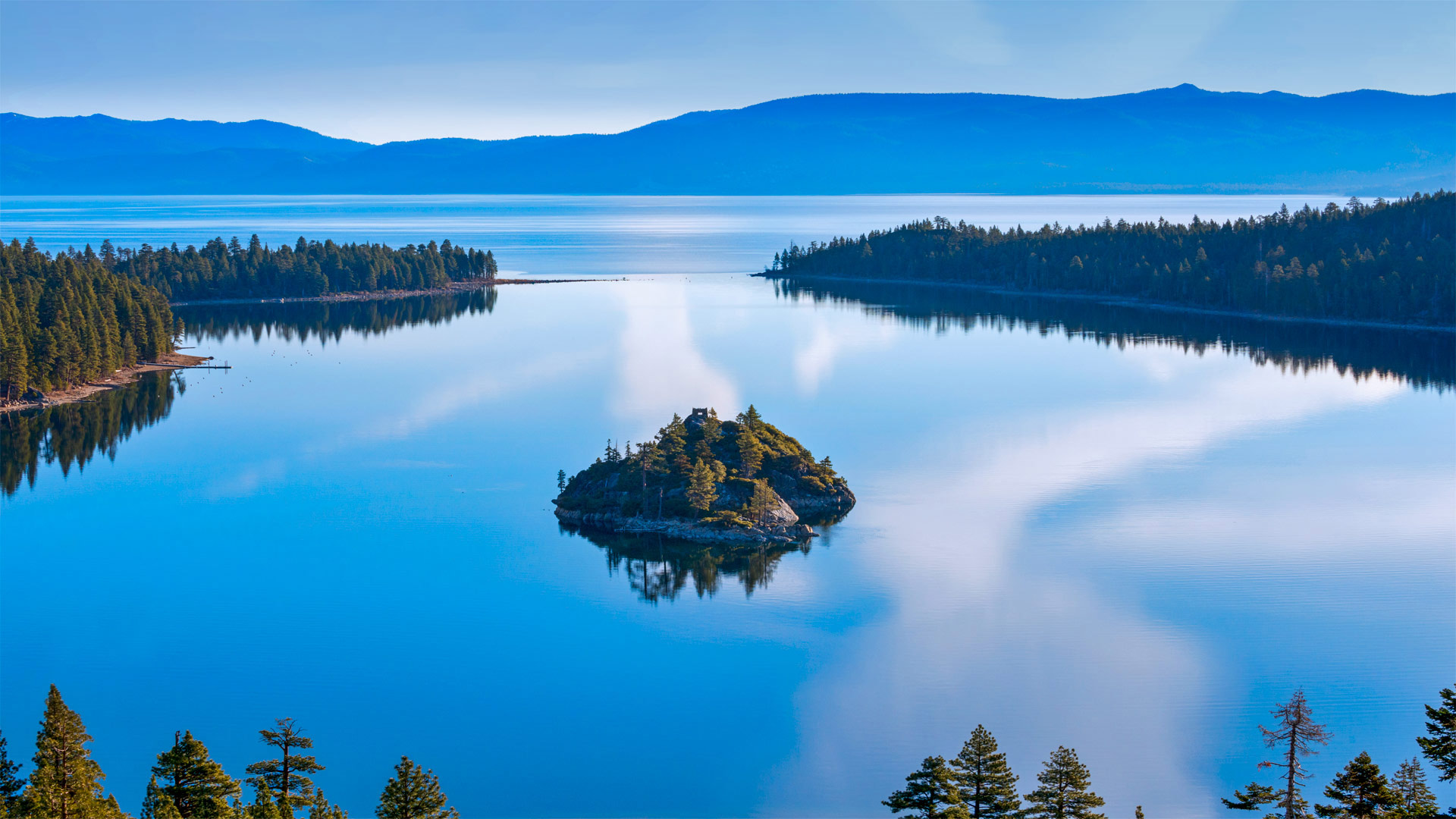
Fannette Island, Lake Tahoe
Tucked into a tiny bay of a grand alpine lake is this granite bump called Fannette Island, the only island in Lake Tahoe. The massive lake lies in the Sierra Nevada at an altitude of 6,225 feet, straddling the state line between California to the west and Nevada to the east with near perfect symmetry. Fannette Island is in Emerald Bay, on the California side of Tahoe's southwest shore. A narrow inlet, seen here at the top center of this image, connects Emerald Bay to the rest of the lake, whose natural beauty draws visitors in all seasons of the year.
Lake Tahoe is known as a mecca for boaters and skiers. Its frigid alpine water is renowned for its clarity. Despite the cold winter temperatures that provide the surrounding ski resorts with ample snowpack, the lake never freezes. The largest alpine lake in North America, Tahoe rivals even the Great Lakes by volume because it is so deep.
Ice-Age glaciers, nature's master sculptors, carved out Emerald Bay eons ago, and for some reason left behind in its wake tiny Fannette Island. It has been known by a half dozen names over the last century, before Fannette finally stuck. A short hike to the top, 150 feet above the water, will take you to the ruins of an old stone building called the 'Tea House,' constructed in the 1920s by the former owner of the island as well as a nearby estate on Emerald Bay called Vikingsholm (the property is now owned by the state and is a popular feature of Emerald Bay State Park). The tea house was used for exactly that, intimate tea parties in surroundings that would be nearly impossible to duplicate in any other home. While tea is no longer served atop the island, the alpine vistas are still there for the taking.
芬尼特岛,太浩湖
在一个巨大的阿尔卑斯湖的一个小海湾里,有一个花岗岩突起,叫做范内特岛,它是太浩湖中唯一的一个岛。这个巨大的湖泊位于内华达山脉,海拔6225英尺,西跨加利福尼亚州,东临内华达州,几乎对称。范内特岛位于翡翠湾,在太浩岛西南海岸的加利福尼亚一侧。图中顶部中央有一个狭窄的小湾,将翡翠湾与湖的其余部分连接起来,湖的自然美景吸引了一年四季的游客。
太浩湖是著名的划船者和滑雪者的圣地。它寒冷的高山水以清澈见长。尽管寒冷的冬季为周围的滑雪场提供了充足的积雪,但湖面从未结冰。塔霍湖是北美最大的阿尔卑斯湖,其湖水如此之深,在容量上甚至可以与五大湖匹敌。
冰河时代的冰川,大自然的大师级雕塑家,在亿万年前就雕刻出了翡翠湾,出于某种原因,留下了小小的范内特岛。在范内特最终坚持之前,在过去的一个世纪里,人们已经知道了半打名字。登上海拔150英尺的山顶,你将看到一座名为“茶馆”的古老石头建筑的废墟,这座建筑是20世纪20年代由该岛的前主人建造的,附近还有一处位于翡翠湾的庄园,名为Vikingsholm(该庄园现在归国家所有,是翡翠湾国家公园的一个热门景点)。茶馆正是用来举办这种亲密的茶话会的,周围的环境几乎不可能在任何其他家庭中复制。虽然岛上不再供应茶,但阿尔卑斯山的景色仍然可以欣赏。
安塞尔·亚当斯的荒野,加利福尼亚 View of Banner Peak from Thousand Island Pass, Ansel Adams Wilderness, California (© Michael DeYoung Photography/Tandem Stills + Motion)
安塞尔·亚当斯的荒野,加利福尼亚 View of Banner Peak from Thousand Island Pass, Ansel Adams Wilderness, California (© Michael DeYoung Photography/Tandem Stills + Motion)
前往山林,今天是国家步道日! Head for the hills, it's National Trails Day!
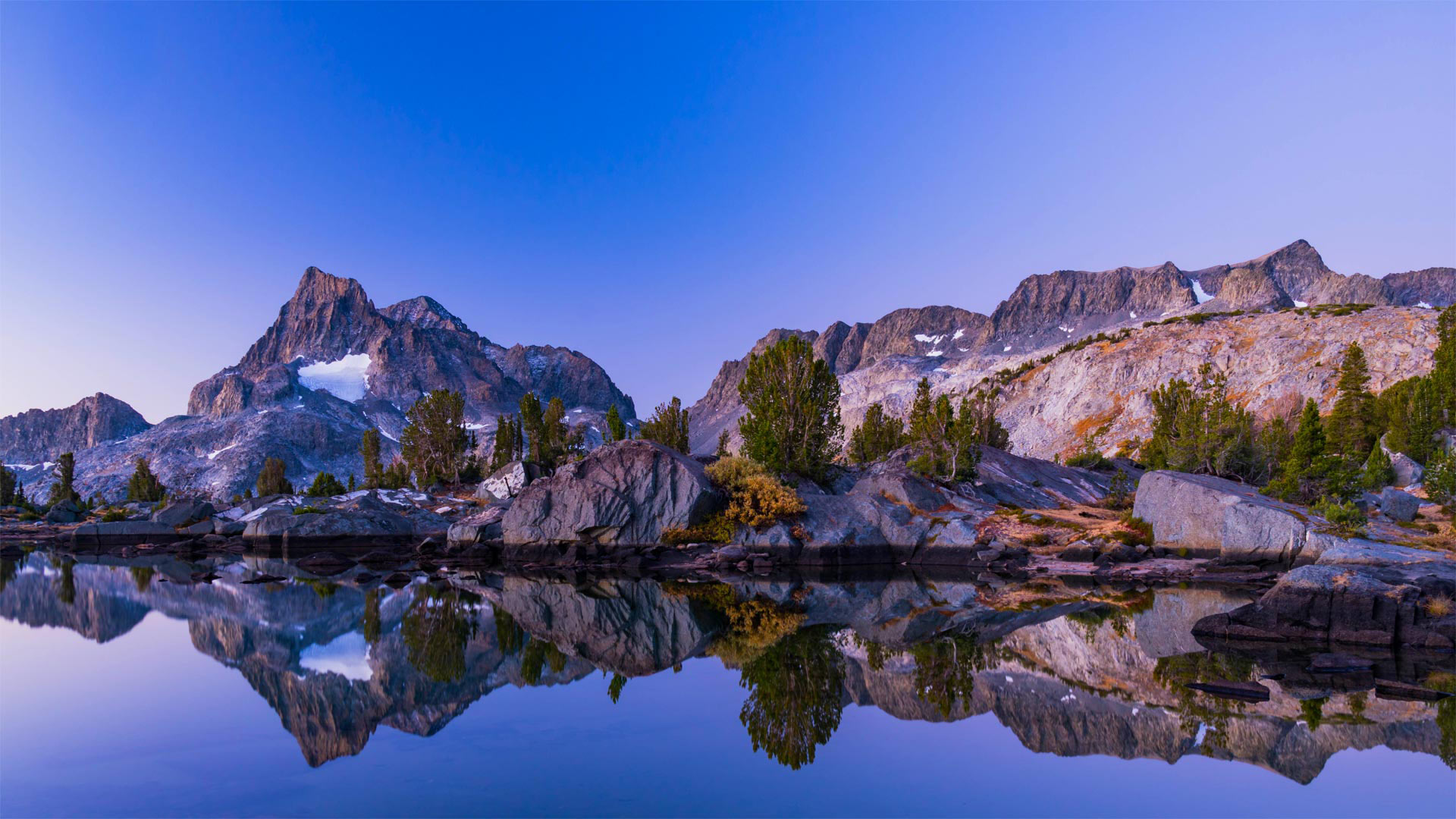
National Trails Day
Whether you're a leisurely day walker or a hardcore hiker, there's a US National Trail with your name on it. Thankfully the trails in the national network are categorized as 'Scenic,' 'Historic,' or 'Recreational' to simplify things. The most famous pathway is the Appalachian Trail ('Scenic'), which was the first to be officially named to the National Trails System when President Lyndon B. Johnson signed the system into law in 1968.
In a speech three years earlier, Johnson had said, 'We can and should have an abundance of trails for walking, cycling, and horseback riding, in and close to our cities. In the backcountry, we need to copy the great Appalachian Trail in all parts of America.' His vision took root, and today there are protected trails across the US, with much of their upkeep carried out by enthusiastic volunteers. If you need an incentive to hit the great outdoors, we reckon this image should do the trick. Banner Peak and Thousand Island Lake in the Ansel Adam Wilderness are highlighted along both the Pacific Crest Trail and the John Muir Trail.
Today is National Trails Day, established by the American Hiking Society as a day of public events aimed at advocacy and trail service. On this day, 'Thousands of hikers, bikers, rowers, horseback riders, trail clubs, federal and local agencies, land trusts, and businesses come together in partnership to advocate for, maintain, and clean up public lands and trails,' the AHS explains. The society aims to protect and enhance US National Trails for generations to come. A current focus is to make sure that trails are inclusive and accessible to everyone.
国家田径日
无论你是一个悠闲的日间旅行者还是一个铁杆徒步旅行者,都有一条美国国家小道,上面写着你的名字。谢天谢地,国家网络中的小径被归类为“风景区”、“历史区”或“休闲区”,以简化事情。最著名的路径是阿巴拉契亚小径(“风景区”),这是1968年林登·B·约翰逊总统将国家小径系统签署为法律时,第一条正式命名为国家小径系统的路径。
在三年前的一次演讲中,约翰逊曾说过:“我们可以而且应该在我们的城市内和附近有大量的小径,可以步行、骑自行车和骑马。”。在偏远地区,我们需要复制美国各地的阿巴拉契亚山脉他的愿景扎根于此,如今,美国各地都有受保护的小径,它们的大部分维护工作都是由热情的志愿者完成的。如果你需要一个动机去户外旅行,我们认为这张图片应该能起到作用。安塞尔亚当荒野中的旗帜峰和千岛湖沿着太平洋顶峰小径和约翰·缪尔小径突出显示。
今天是国家徒步日,由美国徒步旅行协会设立,作为公共活动日,旨在宣传和提供徒步服务。AHS解释说,在这一天,“数千名徒步旅行者、自行车手、划船手、马背骑手、小道俱乐部、联邦和地方机构、土地信托基金和企业携手合作,倡导、维护和清理公共土地和小道。”。该协会旨在为子孙后代保护和加强美国国家步道。当前的一个重点是确保所有人都能访问到包含在内的轨迹。