标签 加利福尼亚 下的文章
保龄球海滩的日落,门多西诺县,加利福尼亚,美国 Sunset on Bowling Ball Beach, Mendocino County, California (© Melo Qiao/Getty Images)
保龄球海滩的日落,门多西诺县,加利福尼亚,美国 Sunset on Bowling Ball Beach, Mendocino County, California (© Melo Qiao/Getty Images)
岩石保龄球 Rock 'n' bowl
保龄球海滩,加利福尼亚州
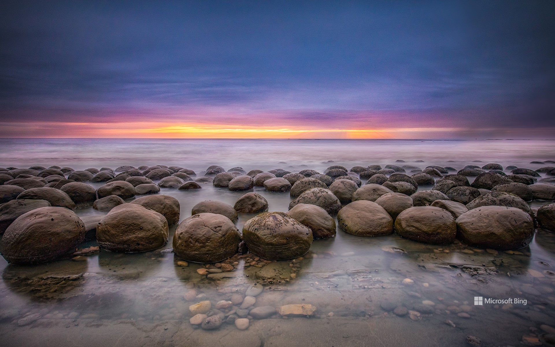
欢迎来到大自然的保龄球馆!位于加州门多西诺海岸的保龄球海滩以散布在海岸上的那些引人注目的岩石而命名。这些砂岩球(一种被称为结核的现象)是在数百万年的沉积过程中形成的,沉积层围绕着由矿物胶结物固定在一起的砂石核心堆积而成。侵蚀作用逐渐磨损了外层,露出我们今天看到的球形。这创造了一个只有在退潮时才会出现的迷人景象。这种砂岩球很罕见,人们对它们的来源有很多疯狂的猜测,有人认为它们是外星碎片,也有人怀疑它们是恐龙化石。然而,答案非常简单:这是大自然的力量在起作用。
Bowling Ball Beach in Mendocino County, California
Welcome to nature's bowling alley. Bowling Ball Beach on the Mendocino Coast in California is named after the striking rock formations strewn across the shore. These sandstone balls—a phenomenon known as concretions—formed over millions of years as sedimentary layers built up around a central core of sand and stone held together by mineral cements. Erosion gradually wore away the outer layers to expose the spherical shapes we see today. This created a fascinating spectacle that only appears at low tide. Concretions are rare, and there has been plenty of wild speculation about where they come from, with some believing them to be extraterrestrial debris while others wonder if they are dinosaur fossils. The answer, however, is quite simple: It is the forces of nature at play.
盛开的扁桃树, 加利福尼亚州,美国 Almond trees in full bloom, California (© Jeffrey Lewis/Tandem Stills + Motion)
盛开的扁桃树, 加利福尼亚州,美国 Almond trees in full bloom, California (© Jeffrey Lewis/Tandem Stills + Motion)
春日私语 Whispers of spring
盛开的扁桃树, 加利福尼亚州
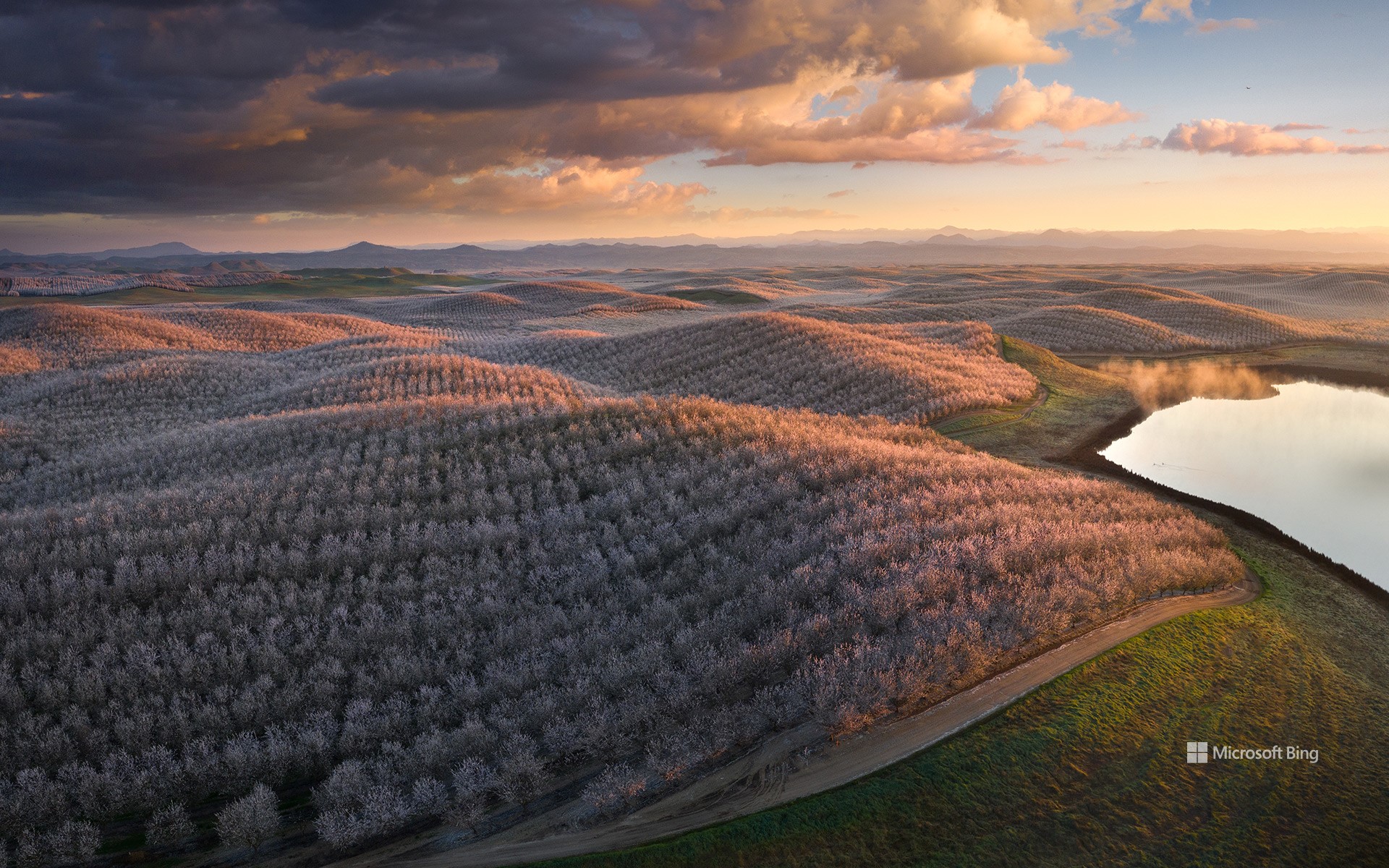
在阳光普照的金州(加利福尼亚州的别称)果园中,扁桃仁享有崇高的地位,它以美味的果实诱惑着人们的味蕾,用漂亮的花朵装点着自然环境。而加利福尼亚州种植的扁桃仁占世界市场供应量的80%,占美国市场供应量的100%。据悉,扁桃仁中含有对心脏有益的单不饱和脂肪,还富含纤维、蛋白质以及大量的维生素和矿物质,是一种营养丰富的食物。二三月份,在加利福尼亚州的中央山谷中,这些扁桃树的种子会从娇嫩的花朵中孕育出来,然后在一种毛茸茸的、有着保护作用的外壳中生长,直至成熟。扁桃树属于蔷薇科,在花期会绽放出美丽的花朵,而这些芬芳的花朵会将果园涂染成白色和粉色色调。
安沙波利哥沙漠州立公园,美国加利福尼亚州 Anza-Borrego Desert State Park, California (© Stephen Matera/Tandem Stills + Motion)
安沙波利哥沙漠州立公园,美国加利福尼亚州 Anza-Borrego Desert State Park, California (© Stephen Matera/Tandem Stills + Motion)
一抹春色 Where is this colorful desert?
安沙波利哥沙漠州立公园,美国加利福尼亚州
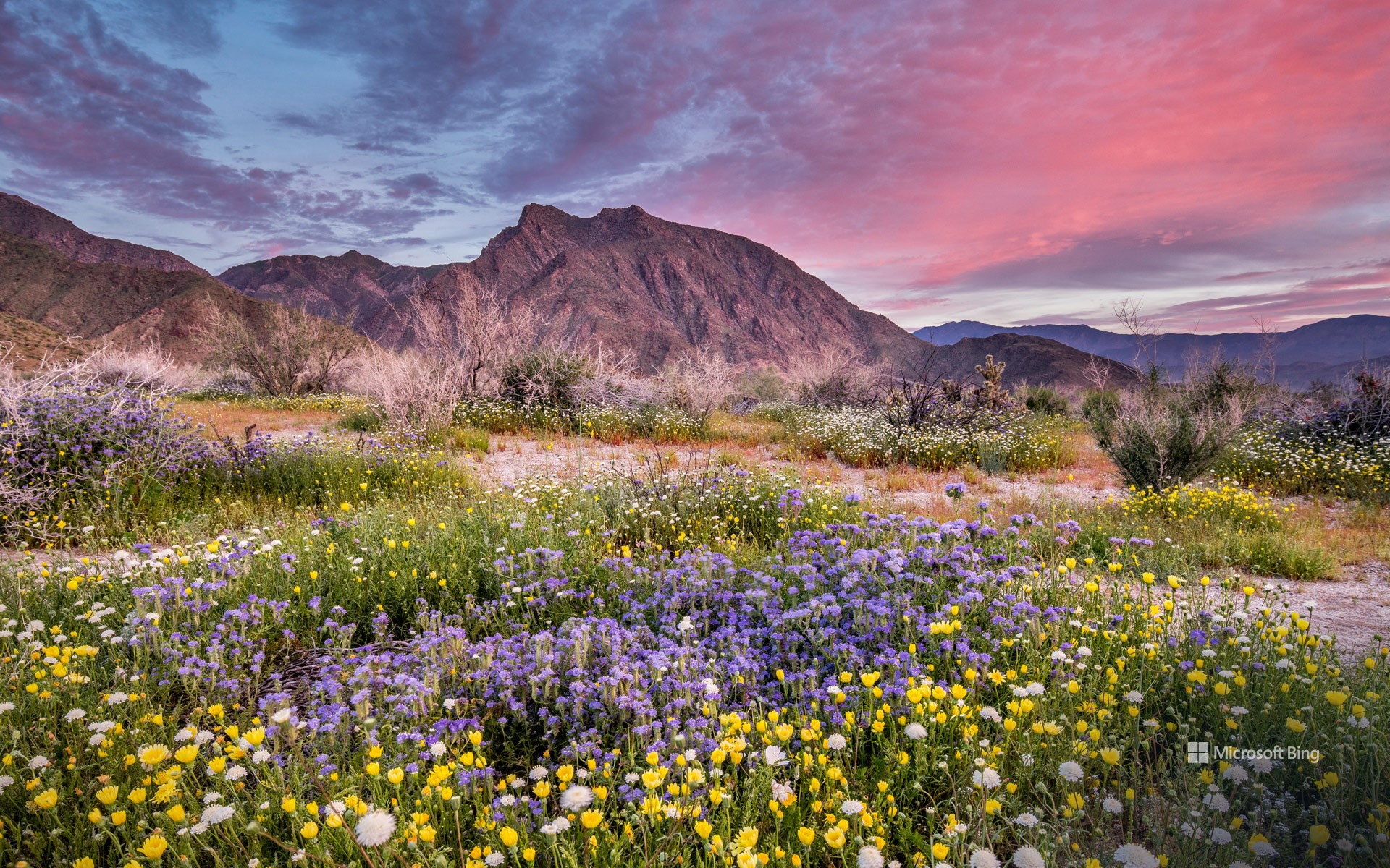
也许距离春天伊始还有好些天,但是加州最大的州立公园——安沙波利哥沙漠州立公园的野花已经在这里向你问好了!每年春天,这片贫瘠的沙漠都会经历一次戏剧性的改变。向日葵、沙漠菊和蒲公英等花朵竞相绽放,形成色彩斑斓的奇观。对于那些想要寻求更多冒险体验的游客来说,从半岛山脉仙人掌丛生的丘陵到峡谷、荒地和天然棕榈绿洲,这个公园有很多可供选择的地方。此外,作为指定的国际黑暗天空公园,这里还是绝佳的观星地点。除了自然奇观之外,占地超过60万英亩的公园还拥有丰富的文化和历史遗产,如古老的象形文字或岩画。
Anza-Borrego Desert State Park, California
The first day of spring may be just days away, but the season's wildflowers at California's largest state park—Anza-Borrego Desert State Park—are already here to say hello! Every spring, this barren desert floor undergoes a dramatic makeover. Flowers like heliotrope, brittlebush, and desert dandelion burst into a riot of bloom, creating a spectacle of color. For those seeking a more adventurous experience, this park has a lot to offer—from the mountains of the Peninsular Ranges and cactus-studded hills to slot canyons, badlands, and natural palm oases. In addition, as a designated International Dark Sky Park, it is an exceptional spot for stargazing. Beyond its natural wonders, the park, spanning over 600,000 acres, is also home to a rich cultural and historical legacy, including ancient pictographs, or rock paintings, from the Native American tribes that once lived here.
火瀑布,优胜美地国家公园,加利福尼亚州,美国 Firefall at Horsetail Fall, Yosemite National Park, California (© Gregory B Cuvelier/Shutterstock)
火瀑布,优胜美地国家公园,加利福尼亚州,美国 Firefall at Horsetail Fall, Yosemite National Park, California (© Gregory B Cuvelier/Shutterstock)
一个天然的矛盾体 A natural oxymoron
优胜美地国家公园的火瀑布
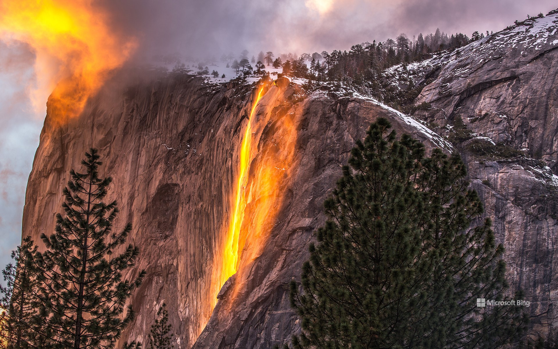
想亲眼目睹炙热的“火瀑布”吗?您没有听错,在优胜美地国家公园里就看到这样一个不可思议的景象。“火瀑布”是季节性瀑布,在冬季和早春时节,当降雪量充足且气温升高到足以融化积雪时,瀑布就会流下来。在二月份的几个星期里,如果天气晴朗,水流正常,而阳光照射的角度又恰到好处时,这条细长的瀑布就会呈现出火焰般的光彩。每年这个时候,会有上百名游客聚集在优胜美地山谷观赏这一奇特迷人的自然景象,山谷里人挤人,连找位置观赏都是一种挑战。有趣的是,这种自然现象被称为“火瀑布”,也是对历史上著名的“优胜美地国家公园火瀑布”的致敬,在1872年至1968年,公园里举办过“人造火瀑布”活动,主办方将余火未尽的木块、煤块推到悬崖下,在黑夜中形成一道炽热亮眼的“火瀑布”。随着时间的推移,公园管理员逐渐认识到这不是一个明智的主意,最终取消了这一活动。
Yosemite National Park, California
Fancy witnessing a fiery waterfall? The seemingly impossible can be found at this time of year on the eastern side of El Capitan, Yosemite National Park's famous rock face. Horsetail Fall is a seasonal waterfall that flows only when there has been plenty of snowfall, and when temperatures have been warm enough to melt it. For a couple of weeks in February, if skies are clear, water is flowing, and the sun shines at just the right angle, the long, slender waterfall takes on a glowing, flame-hued appearance. Hundreds gather in Yosemite Valley to see this mesmerizing natural spectacle. The phenomenon has earned the moniker 'firefall,' an homage to the historic Yosemite Firefall, a manmade event from the top of the park's Glacier Point that took place between 1872 to 1968. Eventually, park rangers decided that dumping embers over a cliff onto the land below wasn't the brightest idea.
冬季日出,沃尔顿灯塔,圣克鲁斯, 加利福尼亚州, 美国 Winter sunrise, Walton Lighthouse, Santa Cruz, California (© Jeff Lewis/Tandem Stills + Motion)
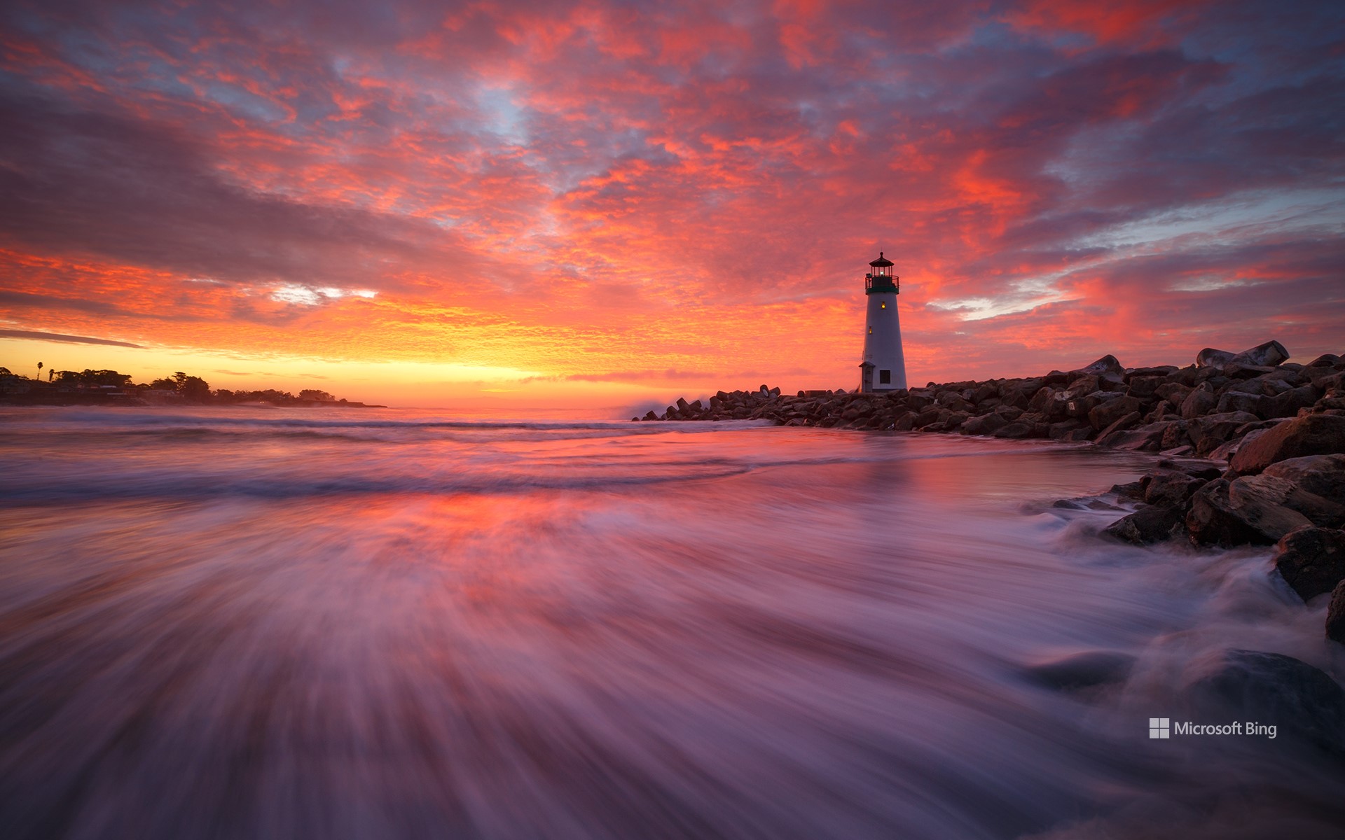
冬季日出,沃尔顿灯塔,圣克鲁斯, 加利福尼亚州, 美国 Winter sunrise, Walton Lighthouse, Santa Cruz, California (© Jeff Lewis/Tandem Stills + Motion)
魔幻时刻 A magic hour indeed
沃尔顿灯塔,圣克鲁斯,加利福尼亚州
走进美国西部边缘,这里是沃尔顿灯塔的所在地。沃尔顿灯塔又名圣克鲁斯防波堤灯塔,是过往船只的指路明灯。2002年,这座40英尺高的现代海上建筑物在加利福尼亚州圣克鲁斯建成完工,取代了之前那座朴素简陋的灯塔。沃尔顿灯塔得名于商人查尔斯·沃尔顿,为了纪念自己的兄弟德里克·沃尔顿,他慷慨地捐赠了这座灯塔的建设费用。
自1800年代中期以来,圣克鲁斯一直是一座繁忙的港口城市,当时的船只会在这里卸下石灰、红木及其他农产品等货物。如今,圣克鲁斯港是商业捕鱼船队的所在地,也是出租皮划艇、小船和冲浪板的热门地点。
Walton Lighthouse, Santa Cruz, California
Step to the western edge of America, where the Walton Lighthouse, also known as the Santa Cruz Breakwater Lighthouse, is a beacon for passing ships. Built in 2002, this 40-foot-tall building replaced a more modest light. The Walton Lighthouse got its name from Charles Walton, a businessman who helped fund its construction in memory of his brother Derek, a merchant seaman who died at sea during World War II.
Santa Cruz has been a busy port city since the mid-1800s, when ships would unload lime, redwood, and other agricultural products. These days, Santa Cruz Harbor is home to a commercial fishing fleet, as well as a popular place to rent kayaks, boats, and paddleboards.
金门大桥,旧金山,加利福尼亚州,美国 Golden Gate Bridge, San Francisco, California (© Jim Patterson/Tandem Stills + Motion)
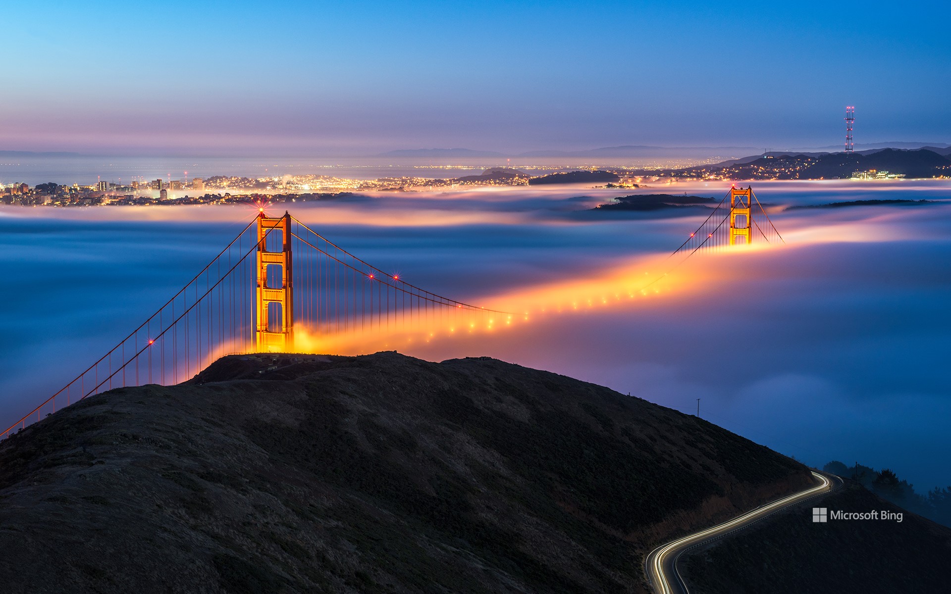
金门大桥,旧金山,加利福尼亚州,美国 Golden Gate Bridge, San Francisco, California (© Jim Patterson/Tandem Stills + Motion)
雾锁金门 On cloud forty-nine
金门大桥,旧金山,加利福尼亚
金门大桥是人类建筑的奇迹,它像哨兵一样矗立在旧金山湾区的入口处。金门大桥被金门海峡水域上方的浓雾所笼罩,桥塔高达746英尺,塔身上有着充满艺术气息的装饰元素。这座大桥是工程师约瑟夫·施特劳斯、建筑师艾尔文·莫罗和其他许多人为连接旧金山和马林县而共同协作的结果。金门大桥被漆成国际橘,而大桥名字中的“金”则指的是桥下那片反射阳光的金门海峡水域。这座桥于1937年向公众开放,但要建成这座大桥并不容易,尤其是在大萧条时期。不过因为它的建设雇用了数千人,间接促进了当地的就业和技术发展,所以付出还是得到了回报。光影变幻,时代变迁,金门大桥不仅成为了人类创新的证明,更是集功能性与美学于一体的永恒杰作。
Golden Gate Bridge, San Francisco, California
An iconic feat of engineering, the Golden Gate Bridge stands like a sentinel at the entrance to San Francisco Bay. Pictured here blanketed by fog above the waters of the Golden Gate Strait, its towers, adorned with Art Deco elements, reach a height of 746 feet. The bridge opened in 1937, thanks to the efforts of engineer Joseph Strauss, architect Irving Morrow, and others who wanted to connect San Francisco to Marin County. It wasn't an easy vision to accomplish during the Great Depression, but the investment paid off as its construction created thousands of jobs and boosted growth. It was Morrow who picked the striking color, International Orange, an unusual choice at the time when many bridges were gray or black. He felt it would contrast well with the surrounding hills, sky, ocean, and fog. The Golden Gate Bridge, a testament to human innovation, is a timeless masterpiece blending functionality with beauty.
恶水盆地的盐滩,死亡谷国家公园,加利福尼亚州,美国 Salt flats in Badwater Basin, Death Valley National Park, California (© Jim Patterson/Tandem Stills + Motion)
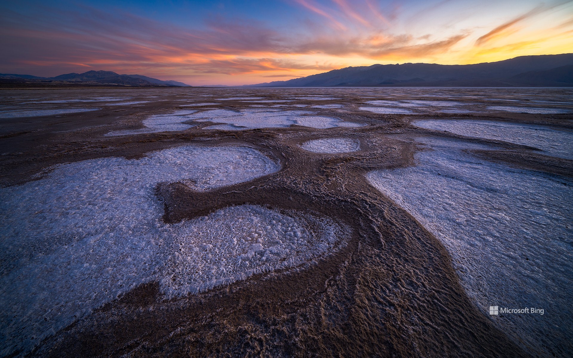
恶水盆地的盐滩,死亡谷国家公园,加利福尼亚州,美国 Salt flats in Badwater Basin, Death Valley National Park, California (© Jim Patterson/Tandem Stills + Motion)
这里,此生值得一去 This park is worth its salt
死亡谷国家公园,加利福尼亚州
沙漠烈日下,恶水盆地的盐滩绵延数英里,在加利福尼亚死亡谷国家公园内熠熠生辉。这里是北美海拔最低的地方,海报高度为-282英尺。在这个仿佛异世界般的景色中,坚硬的矿物表面像镜子一样闪闪发光,炙热的高温在上面跳舞,空气中也掀起了涟漪。盐滩由氯化钠、硼砂和其他矿物质组成,脆弱的外壳下隐藏着一层危险的泥浆层。如果冒险越过盐滩,爬上山坡,站在海拔近5500英尺的丹特观景台上,便可以看到恶水盆地的全景景观。死亡谷国家公园以其超现实的景观,为游客提供了一种真正独特的体验。尽管条件最为恶劣,但仍有一种奇特的美在这里绽放。
Death Valley National Park, California
Stretching for miles below the desert sun, the salt flats of Badwater Basin shine in Death Valley National Park, California. This sweltering spot is the lowest point of elevation in North America, 282 feet below sea level. In this otherworldly landscape, the hardened mineral surface glistens like a mirror as the scorching heat dances upon it, creating rippling waves in the air. Composed of sodium chloride, borax, and other minerals, the flats' brittle crust conceals a treacherous mud layer beneath. For those who venture beyond the flats and up a mountainside, Dante's View reveals a panoramic view of Badwater Basin from a height of nearly 5,500 feet. With its surreal landscapes, Death Valley National Park serves up unique beauty in the harshest of conditions.
鲨鱼鳍湾,达文波特,加利福尼亚州,美国 Shark Fin Cove, Davenport, California (© Jeff Lewis/Tandem Stills + Motion)
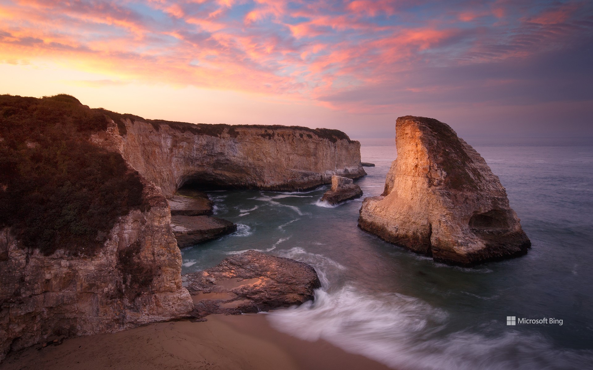
鲨鱼鳍湾,达文波特,加利福尼亚州,美国 Shark Fin Cove, Davenport, California (© Jeff Lewis/Tandem Stills + Motion)
自然“鳍”观 What a fin-tastic view!
鲨鱼鳍湾,加利福尼亚州,美国
鲨鱼鳍湾依偎在加州中部海岸小城达文波特附近海湾一隅。这个海湾中有一个形似鲨鱼鳍的海蚀柱,海湾也因此得名“鲨鱼鳍湾”。这个鲨鱼鳍状的海蚀柱曾是包围海滩的泥岩悬崖的一部分,在长年累月的海浪和大风的侵蚀作用下,最终形成了这个“鲨鱼鳍”。从一号公路上可以看到鲨鱼鳍湾,旅行者可以在此停留,一览无垠的太平洋。
Shark Fin Cove, California
Shark Fin Cove, also known as Shark Tooth Beach, is nestled in a cove in the tiny town of Davenport on California's Central Coast. The cove is a coastal gem known for its stunning sea stack—a vertical rock formation that resembles a shark's fin. The fin used to be connected to the mudstone cliff that surrounds the beach. Over time, the relentless crashing waves and strong winds slowly eroded the rock formation. Shark Fin Cove is visible from Highway 1, where travelers can stop and look at the expansive Pacific Ocean views.
在加利福尼亚州圣地亚哥举行的“为团结划桨”活动 'Paddle Out for Unity' event in San Diego, California (© Brandon Colbert Photography/Getty Images)
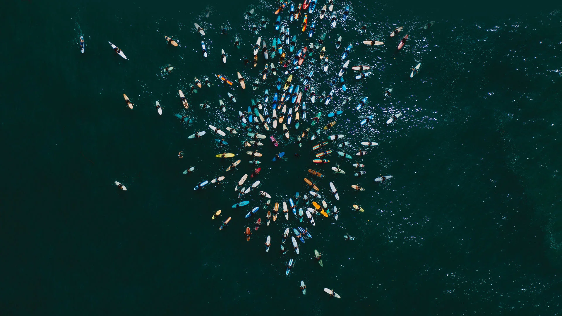
在加利福尼亚州圣地亚哥举行的“为团结划桨”活动 'Paddle Out for Unity' event in San Diego, California (© Brandon Colbert Photography/Getty Images)
桨叶动力 Paddle power
国际冲浪日
国际冲浪日通过激发人们对冲浪的热情来促进对海洋的保护。
每年 6 月的第三个星期六,人们都会聚集在一起参加冲浪比赛、烧烤、海滩清理和其他活动,以帮助恢复和保护海洋环境。
为一项事业走到一起是全球冲浪社区的标志,无论是为了自然还是为了反对不公正,正如他们在 2020
年加利福尼亚州恩西尼塔斯举行的“为团结划桨”聚会上所做的那样,如图所示。
冲浪的历史可以追溯到12世纪的波利尼西亚,那里的人民将这项传统带到了夏威夷。冲浪运动于1885 年在加利福尼亚州圣克鲁斯附近首次在美国亮相,当时四位夏威夷王子在红木板上冲浪圣洛伦佐河。如今,冲浪运动已遍布全球。
International Surfing Day
International Surfing Day promotes the protection of the ocean alongside celebrating the sport itself, every year on the third Saturday in June. People gather for surfing contests, barbeques, beach cleanups, and other activities to help restore the ocean environment. Coming together for a cause is a hallmark of the global surfing community, whether campaigning for cleaner waters or standing together against injustice, as they did at the Paddle Out for Unity gathering in 2020 in Encinitas, California, pictured on our homepage.
Surfing traces back to 12th-century Polynesia, whose people carried the tradition to Hawaii. The sport made its US debut in 1885 near Santa Cruz, California, when four Hawaiian princes surfed the San Lorenzo River on redwood boards. Today, surfing has expanded around the world.
加利福尼亚州圣克鲁斯的天然桥州立公园 Natural Bridges State Beach in Santa Cruz, California (© Jim Patterson/Tandem Stills + Motion)
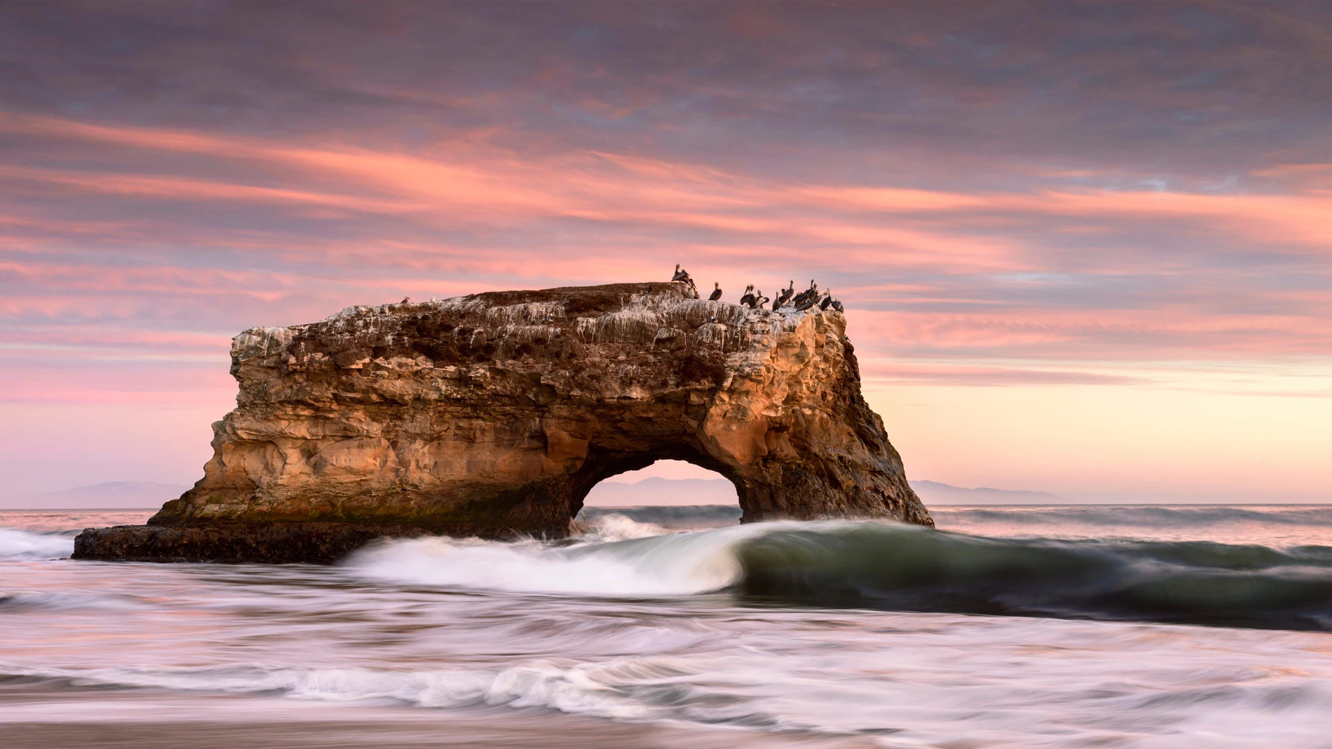
加利福尼亚州圣克鲁斯的天然桥州立公园 Natural Bridges State Beach in Santa Cruz, California (© Jim Patterson/Tandem Stills + Motion)
通往太平洋之窗 A window to the Pacific
天然桥州立公园,加利福尼亚州,美国
天然桥州立公园位于美国加利福尼亚州的圣克鲁斯市。初期,这里有三座海水侵蚀而成的拱桥,其中一座于1905年倒塌,后来又有一座于1980年倒塌,剩下我们如今看到的这座拱桥。然而,海浪的侵蚀是无情的,因此仅剩的这座拱桥最终也会倒塌。除了拱桥,这个公园还有君主斑蝶,因此也吸引了不少游客。
Natural Bridges State Beach in Santa Cruz, California
California brown pelicans, cormorants, and gulls enjoy jostling for position on top of this stunning rock formation in Natural Bridges State Beach in Santa Cruz. It is the sole surviving natural 'bridge' in this state park. Once three bridges stood side-by-side here, carved by waves into cliffs that jutted out into the Pacific. This one stood in the middle, but the outermost bridge collapsed in 1905 and the innermost one disappeared in 1980.
The erosion of the waves is relentless, so eventually the final arch will collapse, and the birds will have to find another favorite perch. But there are plenty of other views on offer. The park is also a seasonal home to migratory monarch butterflies, which flutter through the air or cluster together in its eucalyptus grove. And if you're lucky, you might spot a migrating whale or see seals and otters playing offshore.