蒙特城堡,意大利普利亚大区 Castel del Monte, Apulia, Italy (© Toni Spagone/Alamy)
蒙特城堡,意大利普利亚大区 Castel del Monte, Apulia, Italy (© Toni Spagone/Alamy)
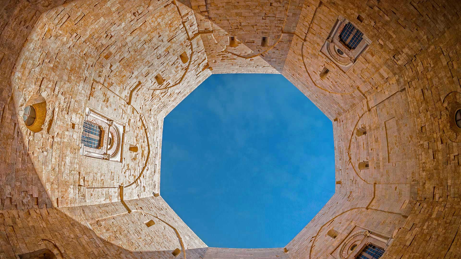
An octagonal architectural treasure
Built in the 1240s by the Holy Roman Emperor Frederick II in southeast Italy, Castel del Monte (Castle of the Mount) features an unusual octagonal design. Eight stone walls stretch between eight octagonal towers and enclose an octagonal courtyard. Each of the two floors also has eight trapezoidal rooms. Acclaimed and protected as a World Heritage Site in 1966, the castle symbolically reflects a harmonious integration of classical Roman, Arabic, and medieval architecture and design—and to some, its octagonal symmetry suggests a connection between heaven and earth.
Its original purpose is unclear. Without a drawbridge, moat, or curtain wall to protect it, it was clearly not a defensive fortress, and its lack of stables call into question its function as a hunting lodge. Over the centuries it has served as a prison and as a refuge from the plague. But whatever the emperor's intention, he left a captivating monument that still enchants today.
八角形建筑瑰宝
蒙特城堡(山上城堡)建于1240年代,由神圣罗马皇帝腓特烈二世在意大利东南部建造,具有不同寻常的八角形设计。八堵石墙在八座八角形塔楼之间延伸,围绕着一个八角形庭院。两层楼各有八个梯形房间。1966年,这座城堡被誉为世界遗产,并受到保护。它象征性地反映了古典罗马、阿拉伯和中世纪建筑与设计的和谐结合,对某些人来说,它的八角对称性暗示着天地之间的联系。
其最初目的尚不清楚。由于没有吊桥、护城河或幕墙的保护,它显然不是一个防御堡垒,而且它没有马厩,这使它作为狩猎小屋的功能受到质疑。几个世纪以来,它一直被用作监狱和躲避瘟疫的避难所。但不管皇帝的意图是什么,他留下了一座迷人的纪念碑,至今仍令人着迷。
圆顶礁国家公园的大教堂谷,犹他州 Mesas, Upper Cathedral Valley, Capitol Reef National Park, Utah (© Tim Fitzharris/Minden Pictures)
圆顶礁国家公园的大教堂谷,犹他州 Mesas, Upper Cathedral Valley, Capitol Reef National Park, Utah (© Tim Fitzharris/Minden Pictures)
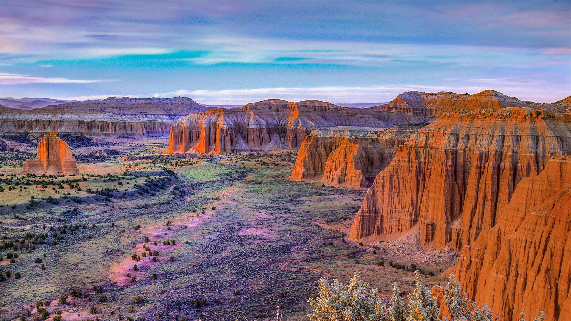
This 'reef' is nowhere near the sea…
…nor the US Capitol building it's named for. Utah's Capitol Reef National Park—first established as a national monument this day in 1937—is named for its massive rock domes that reminded explorers of that famous rotunda back in Washington, DC. Why Capitol 'Reef,' though? Because the imposing formations were a major obstacle to travelers through the region, the same way a coral reef is an obstacle to sailors.
This section of the park, Cathedral Valley, is dotted with monoliths that differ from the namesake domes, instead featuring sheer, jagged walls. While most of the park rests on a steeply warped section of Earth's crust, Cathedral Valley is relatively flat—so rather than carving out gently sloping domes, water erosion here has tended to cut deep, narrow recesses down the rock faces.
这个“暗礁”离海很远…
…也不是以它命名的美国国会大厦。犹他州国会珊瑚礁国家公园于1937年作为国家纪念碑首次建立,以其巨大的岩石圆顶命名,使探险家们想起了华盛顿特区著名的圆形大厅。但为什么国会大厦是“暗礁”?因为壮观的地形是旅行者穿越该地区的主要障碍,就像珊瑚礁是海员的障碍一样。
公园的这一部分,即大教堂谷,点缀着不同于同名圆顶的巨石,取而代之的是陡峭、参差不齐的墙壁。虽然公园的大部分都坐落在地壳急剧弯曲的部分,但大教堂山谷相对平坦,因此这里的水侵蚀倾向于沿着岩石表面切割出深而窄的凹坑,而不是雕刻出缓倾斜的圆顶。
东洛锡安的金黄麦田,苏格兰 Barley field in East Lothian, Scotland (© Scott Masterton/plainpicture)
东洛锡安的金黄麦田,苏格兰 Barley field in East Lothian, Scotland (© Scott Masterton/plainpicture)
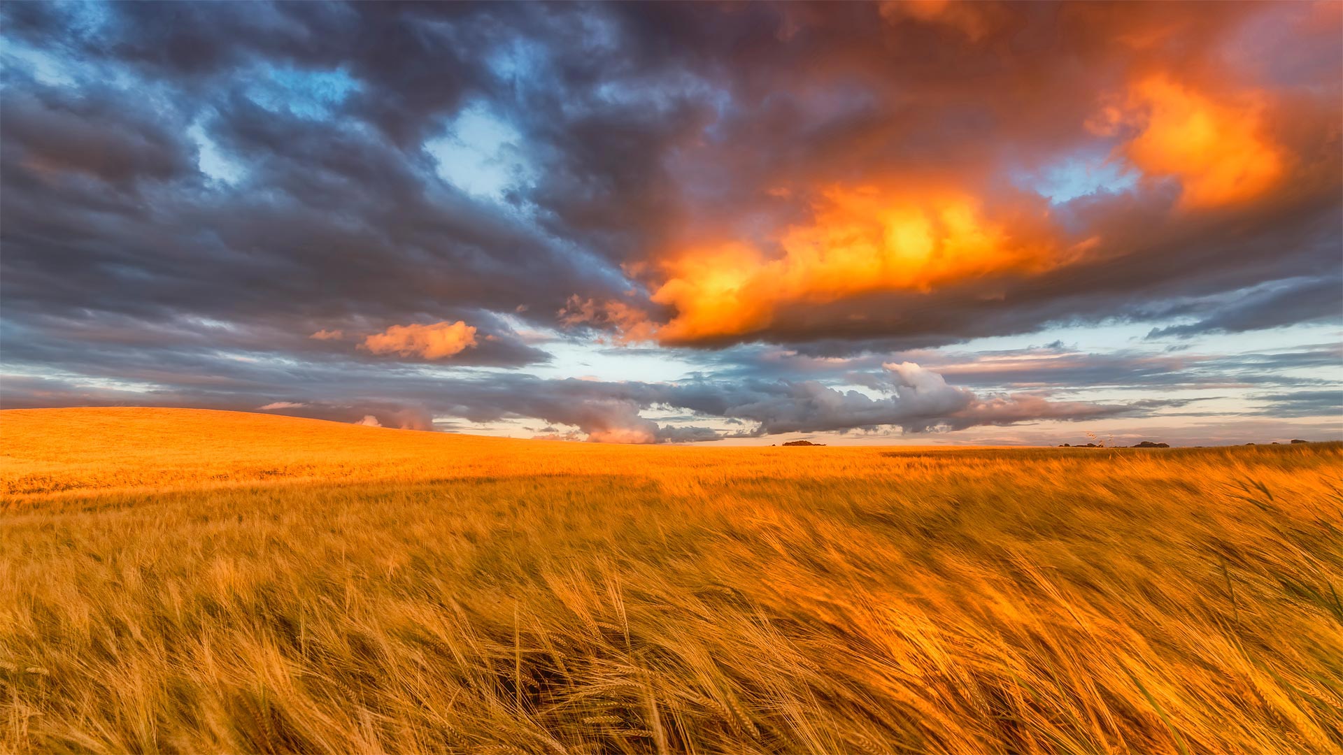
Welcome to Scotland's garden
Today, we're in the 'Garden of Scotland,' better known as the East Lothian region, to pay homage to the area's agricultural roots on Lammas Day. Also known as Loaf Mass Day, it's an observance that marks the beginning of the harvest season and is traditionally celebrated on August 1. The holiday is descended from the ancient British tradition known during the Middle Ages as the Gule of August and was gradually incorporated into the Christian liturgy celebrating Holy Communion. It gets its name from loaves of bread baked from the first harvested grain of the season each year.
Traditionally, Lammastide festivals would mean up to 10 days of raucous eating, drinking, and general merriment. Scottish couples could also take advantage of another common practice during a Lammas fair: a trial marriage, or 'handfast,' where a young couple could live together for a trial period that could last as long as the Lammas festival itself, or even up to a full year. If at the end of the trial the couple decided to call things off, the woman could return to her family with all of her possessions. If a child was born from this union, it would go live with the father without stigma. And while this arrangement seems awfully modern, it was likely just a consequence of a lack of priests—handfasts allowed a single traveling priest to perform all the town's weddings in one day.
欢迎来到苏格兰花园
今天,我们来到了“苏格兰花园”,更著名的是东洛锡安地区,在南丫岛日向该地区的农业根源致敬。也被称为面包弥撒日,这是一个标志着收获季节开始的节日,传统上在8月1日庆祝。这个节日起源于中世纪英国古老的传统,被称为八月红色,并逐渐融入基督教庆祝圣餐的礼拜仪式中。它的名字来源于每年收获的第一批谷物烘焙的面包。
传统上,Lammatide节日将意味着长达10天的喧闹的饮食和一般的欢乐。苏格兰夫妇还可以利用拉玛节期间的另一种常见做法:试婚,或“禁手”,年轻夫妇可以在一起生活一段试婚期,这段试婚期可能与拉玛节本身一样长,甚至长达一整年。如果在庭审结束时,这对夫妇决定取消婚约,这名妇女可以带着她所有的财产回到家中。如果一个孩子是从这种结合中出生的,那么他将与父亲生活在一起,没有任何耻辱感。虽然这种安排看起来非常现代,但很可能只是因为缺少牧师的手铐,一个旅行的牧师可以在一天内完成镇上所有的婚礼。
阿卡迪亚国家公园里的水獭悬崖,缅因州 Otter Cliffs, Acadia National Park, Maine (© dbimages/Alamy)
阿卡迪亚国家公园里的水獭悬崖,缅因州 Otter Cliffs, Acadia National Park, Maine (© dbimages/Alamy)
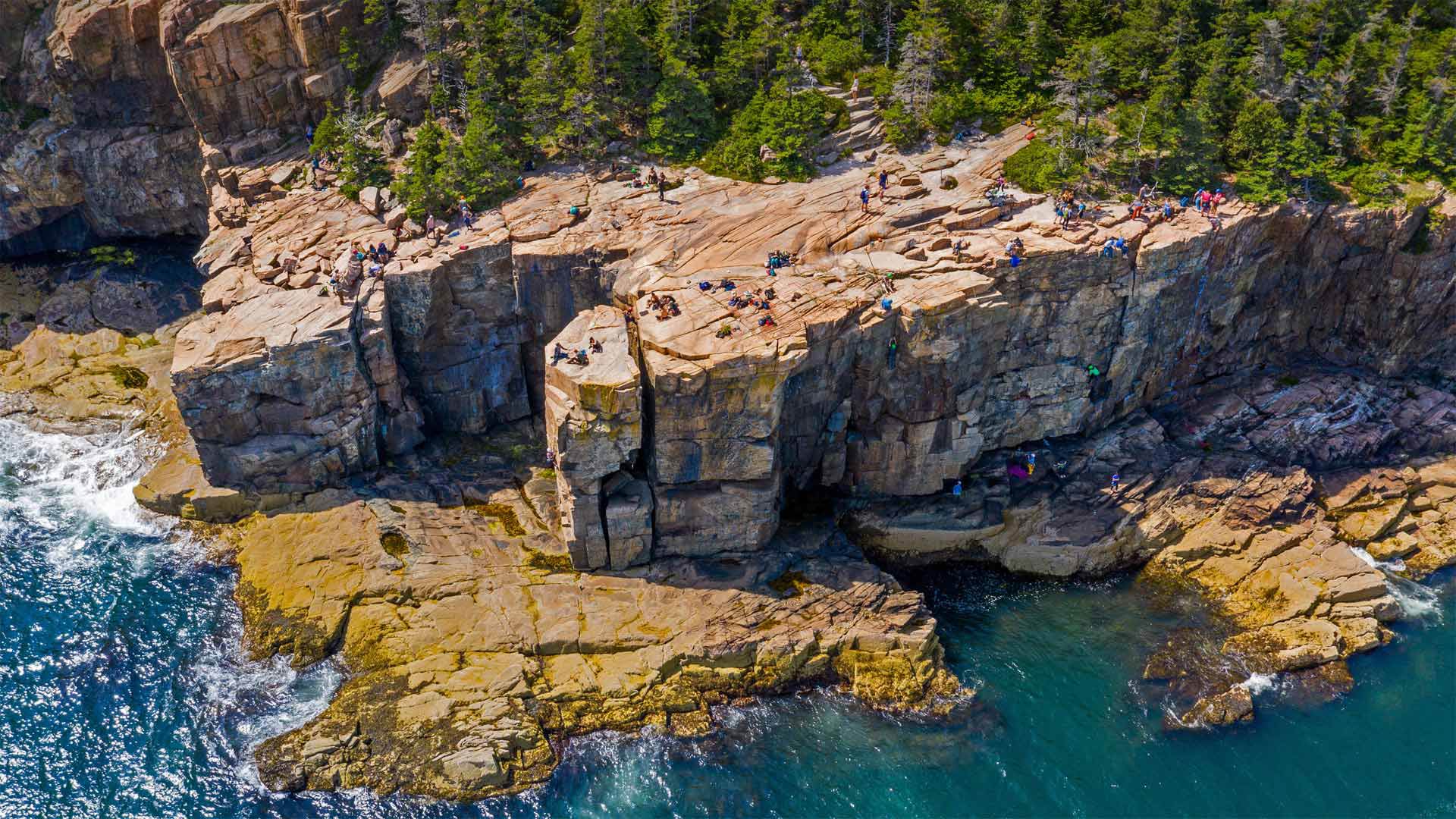
Working for that cliffside view
Maine's Acadia National Park serves up spectacular views at most every turn. But the park's Otter Cliffs on Mount Desert Island offer the adventurous among us a chance to take in the picturesque Atlantic shoreline from the edge of a sheer granite wall. Rising some 60 feet above the crashing waves below, the cliffs are shown here at low tide—when the tide is up, that ledge at the bottom is completely submerged.
The spot's become one of New England's premier climbing destinations, with routes beloved by experts and beginners alike. Climbers begin by either rappelling down the cliff or being lowered from the top. The heart races at the bottom, as waves crash against the seawall right below the climber's shoes and ocean spray makes the first few hand- and footholds slippery. From there, the only way out is up, back to the top of this stunning crag and the cap to a thrilling ascent.
在悬崖边工作
缅因州的阿卡迪亚国家公园最多在每个转弯处都能看到壮观的景色。但公园位于荒山岛上的水獭悬崖为我们中的冒险者提供了一个从陡峭的花岗岩墙边缘欣赏风景如画的大西洋海岸线的机会。这些悬崖高出下面汹涌的海浪约60英尺,在低潮时,当涨潮时,悬崖底部的岩壁完全被淹没。
该景点已成为新英格兰首要的登山目的地之一,其路线深受专家和初学者的喜爱。攀岩者一开始要么从悬崖上攀爬下来,要么从山顶往下爬。当海浪拍打着登山者鞋下的海堤时,心脏在底部跳动,海水的浪花使最初的几个手和脚点变得很滑。从那里出发,唯一的出路就是爬上,回到这座令人惊叹的峭壁的顶端,再爬上令人激动的山峰。
密歇根湖畔的阿德勒天文馆, 芝加哥伊利诺伊州 Adler Planetarium near Lake Michigan, Chicago, Illinois (© Amazing Aerial Agency/Offset by Shutterstock)
密歇根湖畔的阿德勒天文馆, 芝加哥伊利诺伊州 Adler Planetarium near Lake Michigan, Chicago, Illinois (© Amazing Aerial Agency/Offset by Shutterstock)
America's oldest planetarium
When it first flicked on the projector lights in 1930, the Adler Planetarium in Chicago was the only one in the Western Hemisphere. At the time, planetariums themselves were only a 7-year-old invention imported from German lens grinders. But the American public's fascination with stars and distant worlds, it turned out, was skyrocketing. By 1934, the Adler had welcomed over a million visitors.
And though our love for space endures, these days in Chicagoland it's tough to catch a clear night sky past all those wonderful bright lights of the Windy City. That helps explain why the Adler still pulls half a million visitors in a typical year, with three state-of-the-art auditoriums and even a massive telescope that lets visitors view far-off galaxies.
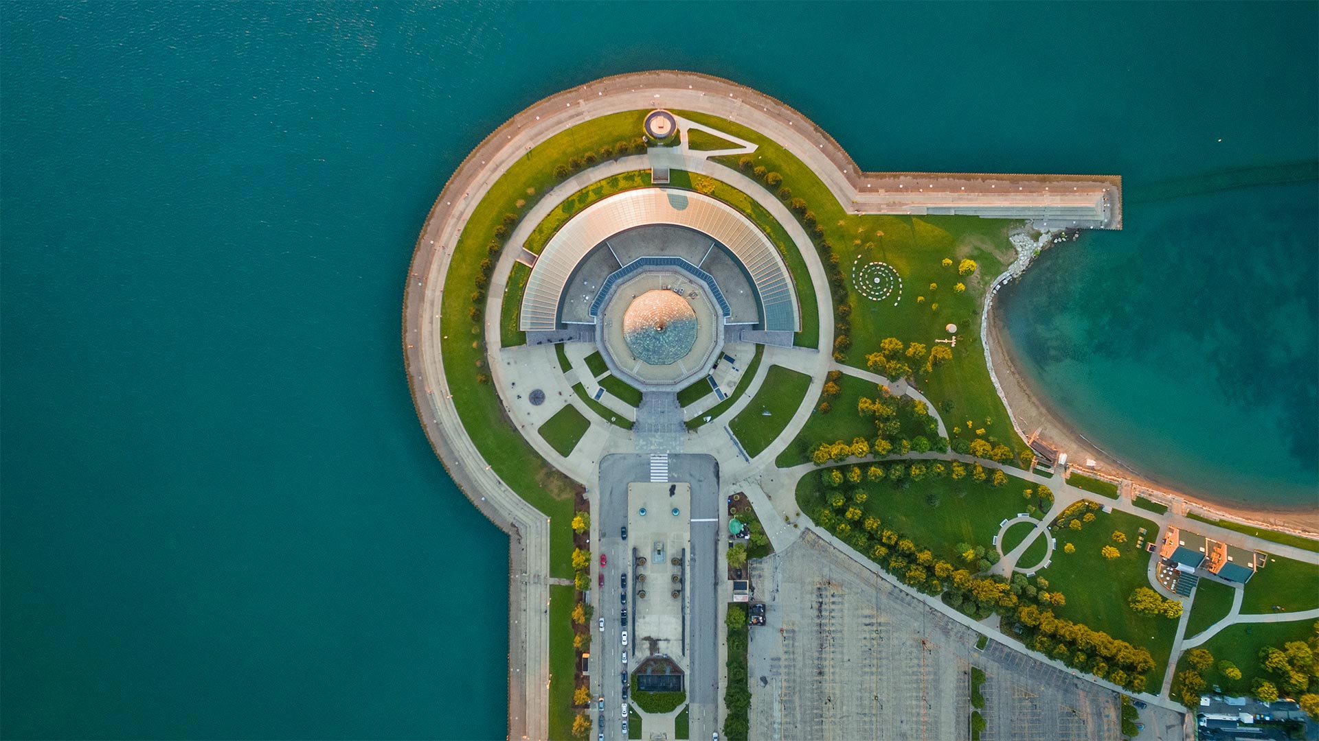
美国最古老的天文馆
1930年,芝加哥的阿德勒天文馆(Adler Planetarium)第一次打开投影仪的灯光时,是西半球唯一的天文馆。当时,天文馆本身只是从德国镜头研磨机进口的一项7年发明。但事实证明,美国公众对星星和遥远世界的迷恋正在飙升。到1934年,阿德勒号已经接待了超过一百万的游客。
尽管我们对太空的热爱永存,但如今在芝加哥,要想在这座多风的城市里捕捉到一片晴朗的夜空是很困难的。这有助于解释为什么阿德勒号在一个典型的年份里仍然吸引了50万游客,有三个最先进的礼堂,甚至还有一个巨大的望远镜,可以让游客观看遥远的星系。
乌鲁鲁艺术家布鲁斯·蒙罗的《光之领域》, 澳大利亚 'Field of Light' by artist Bruce Munro at Uluru, Australia (© Sheralee Stoll/Alamy
乌鲁鲁艺术家布鲁斯·蒙罗的《光之领域》, 澳大利亚 'Field of Light' by artist Bruce Munro at Uluru, Australia (© Sheralee Stoll/Alamy)
Illuminated Uluru
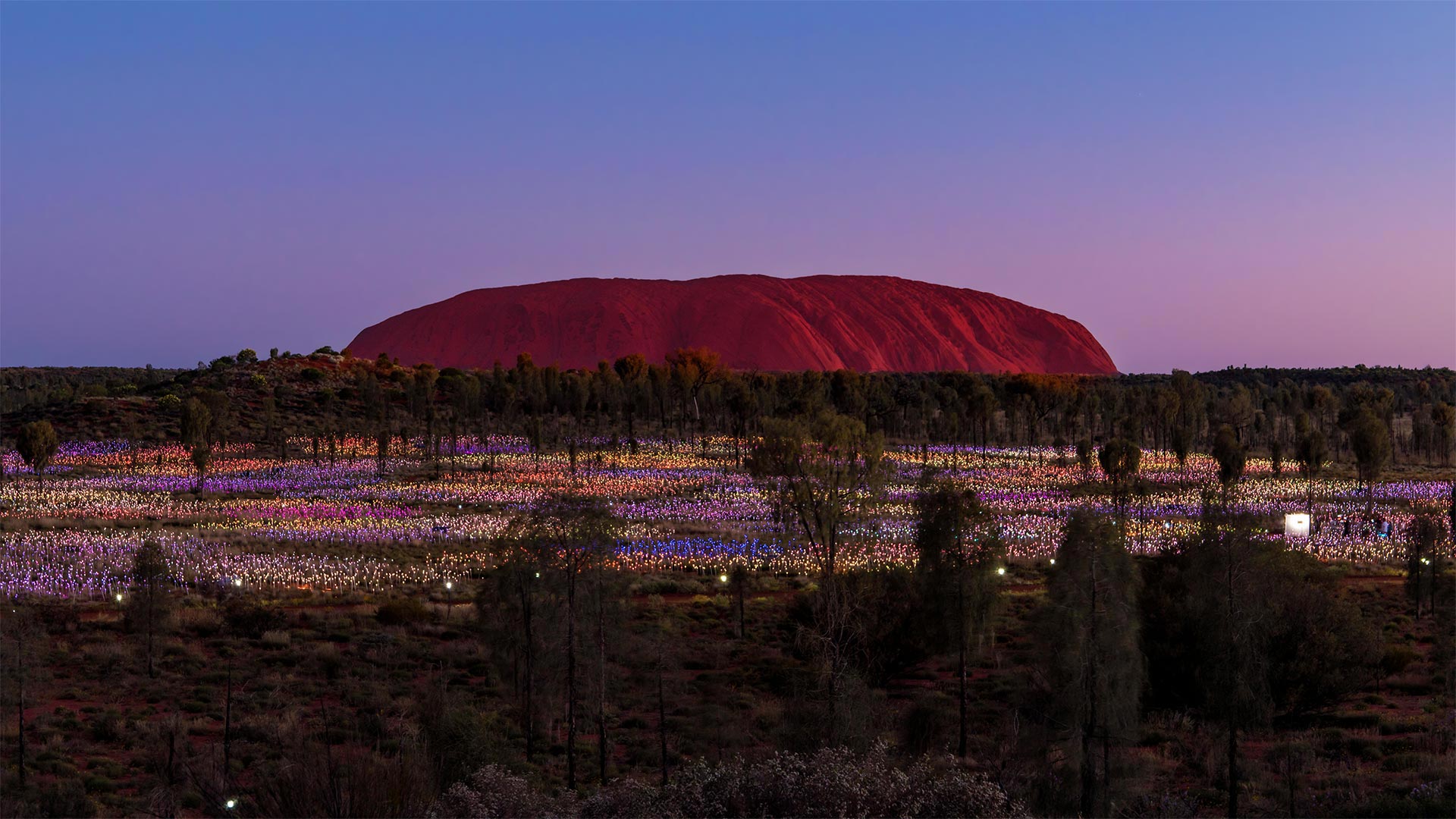
This landmark of the Land Down Under is usually pictured in sweltering desert sunlight. Now a 21st-century addition near the ancient rock of Uluru has people flocking here even at night.
Bruce Munro's 'Field of Light' installations—which blanket landscapes in thousands of small LED lights—have appeared around the globe, first in the artist's native England. But it was decades ago while camping here at Uluru that Munro first had the idea for an immersive artwork that would bathe its surroundings in soft light nightly, like desert flowers that bloom after dusk in the Australian Outback. Munro was finally able to bring 'Field of Light' to this forest near Uluru in 2016, and it became so popular with visitors that it's been extended indefinitely.
照明乌鲁鲁
下面这片土地的地标通常是在闷热的沙漠阳光下拍摄的。现在,在乌鲁鲁古岩附近的一个21世纪的新建筑里,人们甚至在晚上都聚集在这里。
布鲁斯·蒙罗的“光的领域”装置覆盖了数千个小型LED灯的景观,出现在世界各地,首先是在艺术家的祖国英格兰。但几十年前,蒙罗在乌鲁鲁露营时,第一次想到了一件身临其境的艺术品,每晚都能沐浴在柔和的光线中,就像澳大利亚内陆黄昏后盛开的沙漠花朵。蒙罗终于在2016年将“光之场”带到了乌鲁鲁附近的这片森林,它受到了游客的欢迎,因此被无限期地延长了。
Walakiri海滩的红树林,印度尼西亚松巴岛 Mangrove trees, Walakiri Beach, Sumba Island, Indonesia (© Tengguo Wu/Getty Images)
Walakiri海滩的红树林,印度尼西亚松巴岛 Mangrove trees, Walakiri Beach, Sumba Island, Indonesia (© Tengguo Wu/Getty Images)
The 'dancing trees' of Sumba Island
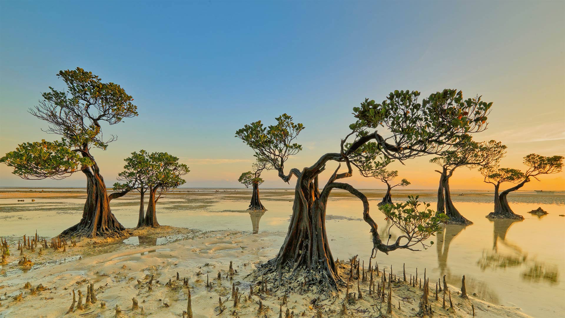
On the northern coast of Indonesia's Sumba Island, a stand of mangrove trees appears to dip and sway to summon another dreamy sunrise. Walakiri Beach is gently sloped, so it's easy for a visitor to walk out into the knee-deep water to examine the extraordinary transitional zone of a mangrove ecosystem. Mangroves thrive here at the boundary between land and sea, growing in coastal salt water and low-oxygen conditions where other trees would quickly die. Their complex root systems filter out the salt and form a strong natural defense against storm surges, rising sea levels, and coastal erosion. Mangroves also create aquatic nursery habitats that support a highly diverse range of juvenile fish and crustaceans.
But despite their critical role in maintaining healthy oceans and coastlines, mangroves are disappearing fast, several times faster than forests on land. The United Nations estimates that the world has lost half its mangrove coverage in just the last 40 years. To raise awareness of the importance of mangrove ecosystems and to promote solutions for their sustainable management and conservation, the UN has declared that July 26 is International Day for the Conservation of the Mangrove Ecosystem. We'll dance to that.
桑巴岛的“舞动的树”
在印度尼西亚苏姆巴岛的北部海岸,一片红树林似乎在倾斜和摇摆,召唤着另一个梦幻般的日出。瓦拉基里海滩的坡度很平缓,因此游客很容易走出去,走进齐膝深的海水中,去考察红树林生态系统中非同寻常的过渡地带。红树林生长在陆地和海洋的交界处,生长在沿海咸水和低氧环境中,其他树木很快就会死亡。它们复杂的根系过滤掉盐分,形成强大的天然防御系统,抵御风暴潮、海平面上升和海岸侵蚀。红树林还创造了水生苗圃栖息地,支持高度多样化的幼鱼和甲壳类动物。
但是,尽管红树林在维持海洋和海岸线健康方面发挥着关键作用,但它们正在迅速消失,比陆地上的森林快数倍。联合国估计,仅仅在过去40年里,世界红树林的覆盖率就减少了一半。为了提高人们对红树林生态系统重要性的认识,促进红树林生态系统的可持续管理和保护,联合国宣布7月26日为国际红树林生态系统保护日。我们就跟着跳舞。
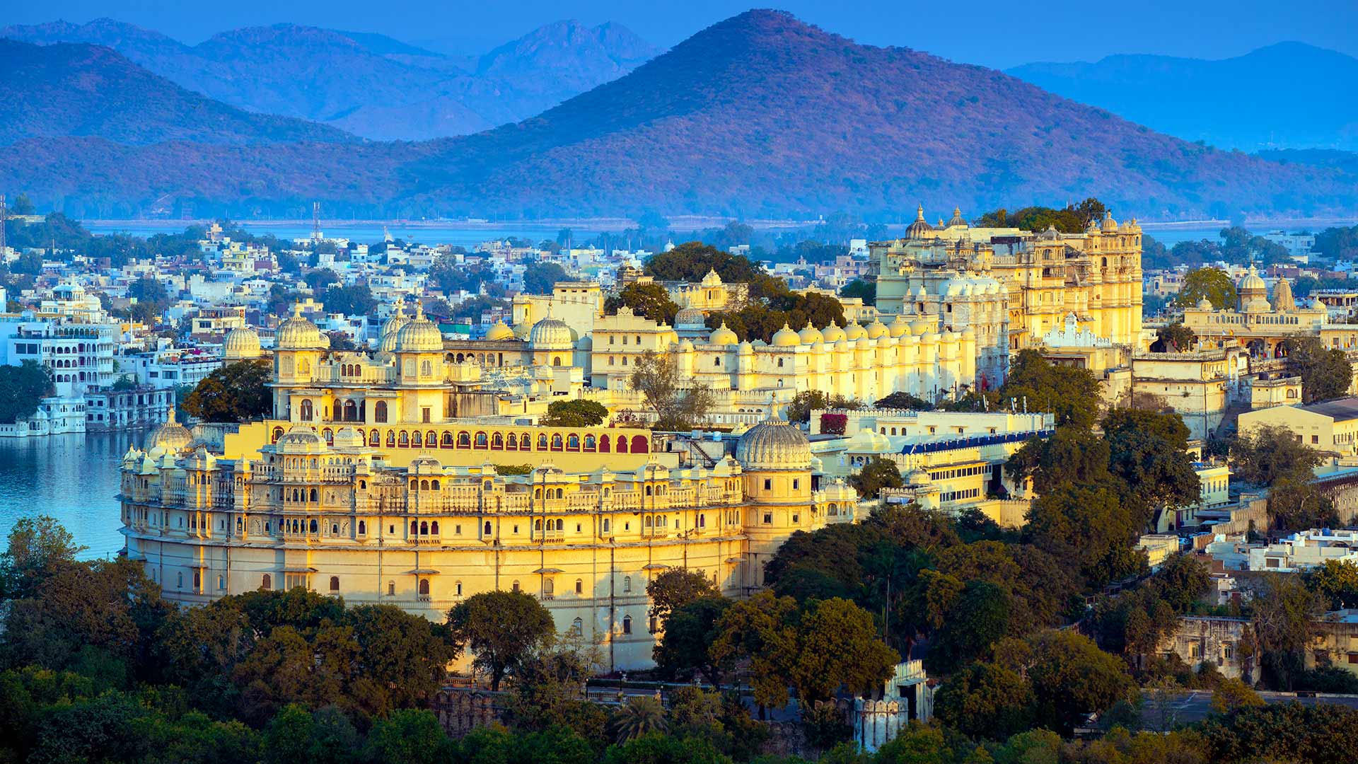
皮丘拉湖畔的乌代布尔城市宫殿,印度 (© Chaiyun Damkaew/Getty Images)
东京塔,日本东京都港区 Tokyo Tower in Minato City, Tokyo, Japan (© Yukinori Hasumi/Getty Images)

东京塔,日本东京都港区 Tokyo Tower in Minato City, Tokyo, Japan (© Yukinori Hasumi/Getty Images)
Let the games (finally) begin!
Shining like an incandescent Olympic torch, the Tokyo Tower is our cue to finally say, 'Let the games begin!' Along with so much else, the 2020 Summer Olympics were postponed last year (as you probably heard). But with Covid-19 vaccinations well underway and capacity restrictions in place, Tokyo is hosting the Summer Olympics opening ceremony today, almost exactly one year after the games were originally due to start.
The events will be held at 42 venues in and around the city, with most held in Tokyo itself. Organizers expect some 11,000 athletes from about 200 countries to compete. Four sports will make their Olympic debuts at the Tokyo Games: karate, sport climbing, surfing, and skateboarding. Also, baseball and softball, which were last held in 2008, are being reintroduced. Closing ceremonies are scheduled for August 8. Game on!
让竞技(终于)开始吧!
东京塔就像一个炽热的奥运火炬一样闪耀着光芒,它是我们最后一次说‘让奥运开始吧!’与其他许多事情一样,2020年夏季奥运会去年也被推迟了(你可能听说过)。但随着Covid-19疫苗接种工作的顺利进行和容量限制的到位,东京今天将举办夏季奥运会开幕式,几乎正好是奥运会原定开幕一年之后。
这些活动将在东京市内及周边的42个场馆举行,其中大部分在东京举行。组织者预计将有来自大约200个国家的11000名运动员参赛。四个项目将在东京奥运会上首次亮相:空手道、攀岩、冲浪和滑板。此外,棒球和垒球,上次是在2008年举行,正在重新引进。闭幕式定于8月8日举行。比赛开始!
伊豆半岛海岸附近的 Minokake-Iwa 奇岩群,日本 The Minokake-Iwa rocks off the coast of the Izu Peninsula, Japan (© Krzysztof Baranowski/Getty Images)
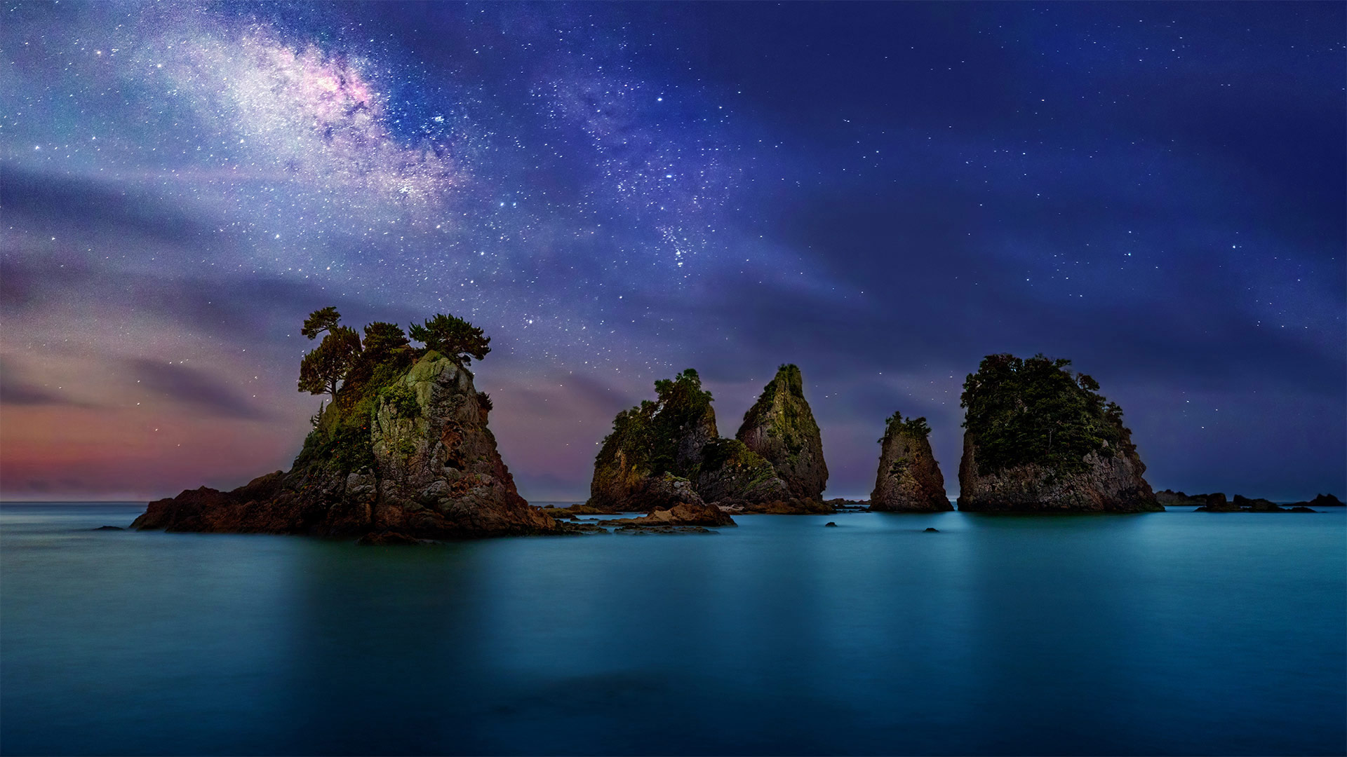
伊豆半岛海岸附近的 Minokake-Iwa 奇岩群,日本 The Minokake-Iwa rocks off the coast of the Izu Peninsula, Japan (© Krzysztof Baranowski/Getty Images)
Singing praises of the oceans
In Japan, mid-July brings an excuse to head to the beach, as if we really needed one. That's because this time of year marks Marine Day (aka Ocean Day), an observance recognizing the close bond the island nation shares with the seas and ocean that surround it. Because Marine Day roughly coincides with the end of the rainy season, it has, over the years, become a sort of unofficial kick off to the hot summer season. One place sure to attract visitors is the picturesque Minokake-Iwa rock formation seen here, lying off the coast of Honshū's mountainous 31-mile-long Izu Peninsula.
Ordinarily Marine Day is observed on the third Monday in July, but this year the holiday was moved to immediately precede the start of the Summer Olympics in Tokyo. So, this is the day to hit the beach in Japan, just before the Olympics' opening ceremonies begin tomorrow.
歌颂海洋
在日本,七月中旬给我们带来了一个去海滩的借口,好像我们真的需要一个。这是因为每年的这个时候都是海洋日(又名海洋日),这是一个认可岛国与周围海洋紧密联系的节日。由于海洋日大致与雨季的结束相吻合,多年来,它已成为炎热夏季的一种非正式开端。一个肯定会吸引游客的地方是这里风景如画的Minokake Iwa岩层,位于本什岛31英里长的伊豆半岛的海岸线附近。
通常海洋日是在七月的第三个星期一,但是今年这个节日被转移到了东京夏季奥运会开始之前。所以,今天是去日本海滩的日子,就在明天奥运会开幕式开始之前。