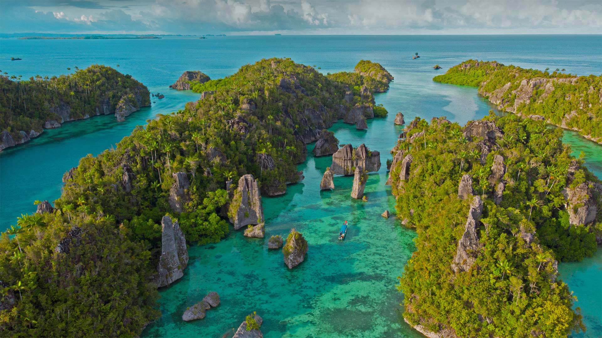
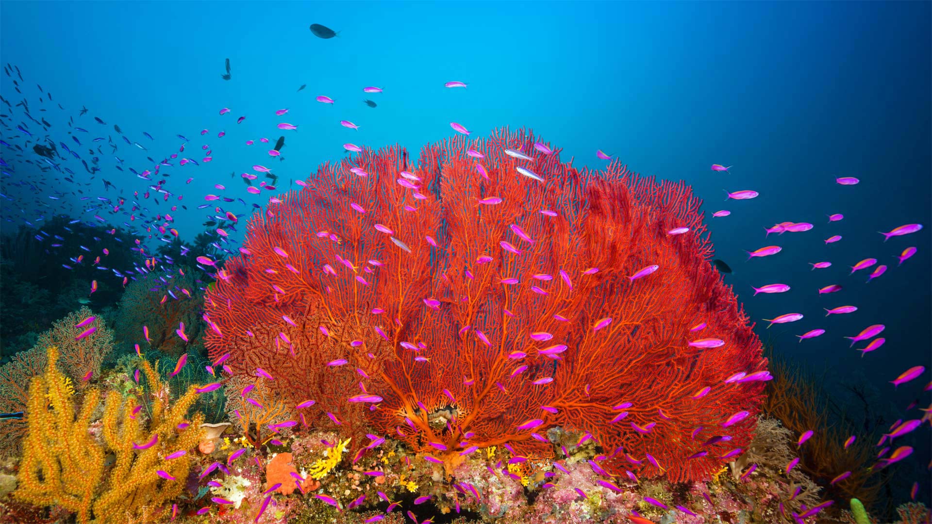
米苏尔岛,拉贾安帕特群岛中的岛屿,印度尼西亚 Misool Island, one of the four major islands in the Raja Ampat Islands in West Papua, Indonesia (© rusm/Getty Images)
米苏尔岛,拉贾安帕特群岛中的岛屿,印度尼西亚 Misool Island, one of the four major islands in the Raja Ampat Islands in West Papua, Indonesia (© rusm/Getty Images)
一个可供探险的水下天堂 An underwater paradise to explore
Misool Island, Indonesia
You may think finding a tropical paradise that's still largely untouched by people is merely a pipe dream. You may be wrong. Raja Ampat, an archipelago in the province of West Papua, Indonesia, has a mere 50,000 inhabitants, and they all live on or around its four main islands—Batanta, Misool, Salawati, and Waigeo. (In fact, the name Raja Ampat means 'Four Kings' and derives from an ancient legend that says four young kings were hatched from dragon eggs, one ruler for each of those main islands.) The rest of Raja Ampat is made up of about 1,500 smaller islands and cays—and astonishingly, hundreds of these tiny islands have yet to be explored by humans.
Of course, the lack of people is critical to keeping this paradise pristine. The main visitors today tend to be adventurous divers and snorkelers, who love exploring Raja Ampat and its vast reef system. And for good reason: It's considered one of the most biodiverse places in the world. The ecosystem, which is part of a larger tropical ocean area called the Coral Triangle, is so diverse that it's sometimes referred to as 'the Amazon of the seas.' Raja Ampat stretches over nearly 10 million acres of land and sea, and it boasts 540 types of coral, more than 1,000 species of coral reef fish, 700 kinds of mollusks, and a variety of warm-blooded marine animals (including migratory snorkelers and scuba-divers).
印度尼西亚米苏尔岛
你可能会认为,找到一个基本上还没有被人们触及的热带天堂只是一个白日梦。你可能错了。拉贾·安巴特是印尼西巴布亚省的一个群岛,仅有50000名居民,他们都居住在巴坦塔、米苏尔、萨拉瓦蒂和瓦吉奥四个主要岛屿上或周围。(事实上,Raja Ampat这个名字的意思是“四个国王”,来源于一个古老的传说,传说四个年轻的国王是从龙蛋孵化出来的,每个主要岛屿都有一个统治者。)Raja Ampat的其余部分由大约1500个较小的岛屿和珊瑚礁组成,令人惊讶的是,数百个这样的小岛尚未被人类探索。
当然,缺少人对于保持这个天堂的原始状态至关重要。今天的主要游客往往是喜欢冒险的潜水员和浮潜者,他们喜欢探索拉贾安巴特及其巨大的珊瑚礁系统。理由很充分:它被认为是世界上生物多样性最丰富的地方之一。该生态系统是一个称为珊瑚三角洲的较大热带海洋区域的一部分,其多样性如此之大,有时被称为“海洋亚马逊”Raja Ampat占地近1000万英亩,拥有540种珊瑚、1000多种珊瑚礁鱼类、700种软体动物和各种温血海洋动物(包括迁徙的浮潜者和潜水者)。
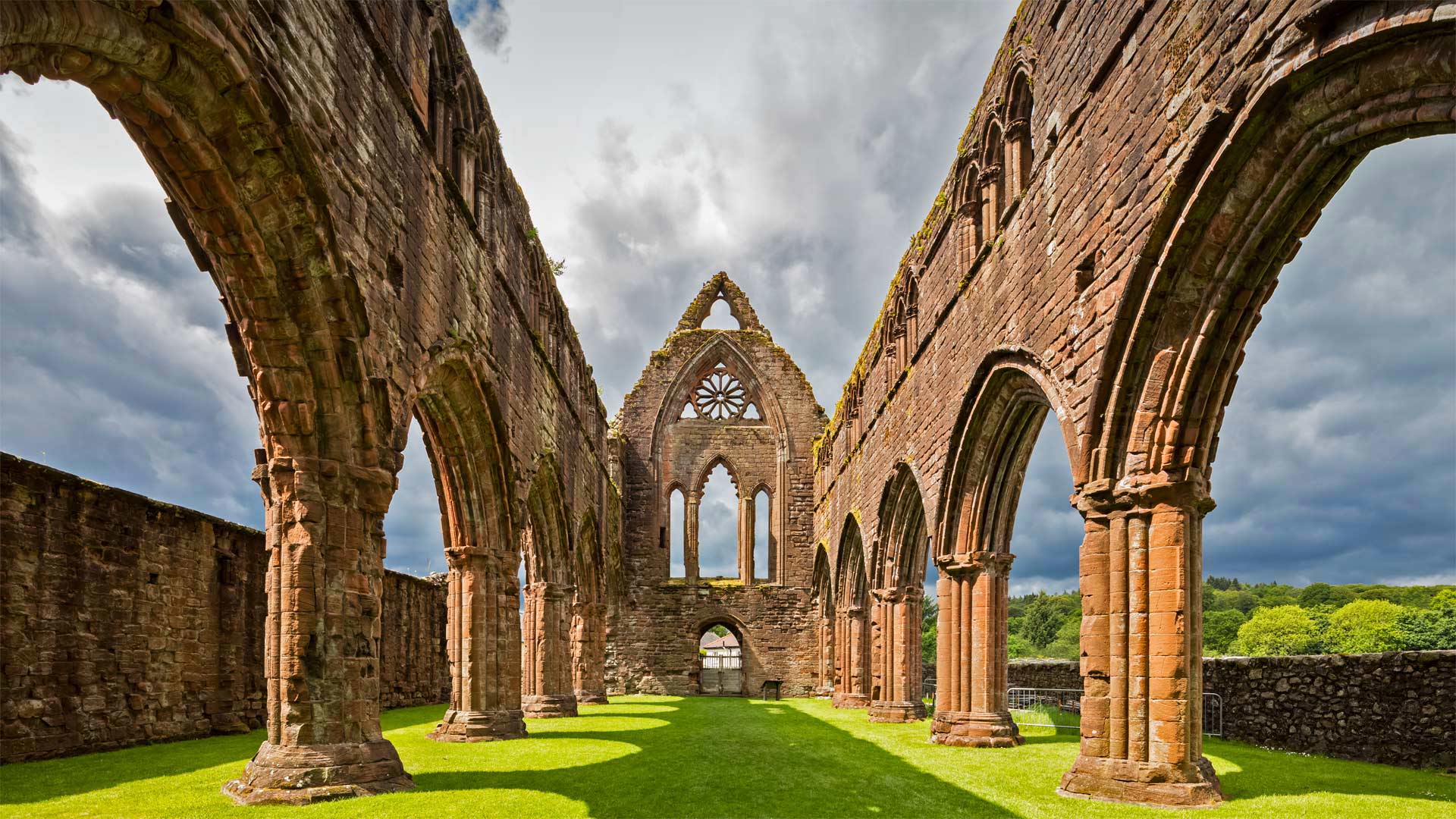
邓弗里斯和加洛韦的甜心修道院,苏格兰 Sweetheart Abbey, Dumfries and Galloway, Scotland (© Westend61/Getty Images)
邓弗里斯和加洛韦的甜心修道院,苏格兰 Sweetheart Abbey, Dumfries and Galloway, Scotland (© Westend61/Getty Images)
一场光明正大的示爱 A very public display of affection
Sweetheart Abbey, Scotland
They say Paris is 'the city of love' but there's a lesser-known place where love is the whole reason it even exists. We're in a Scottish village now known as New Abbey, about 6 miles south of Dumfries. We've stepped inside the ruins of Sweetheart Abbey, the testament to a 13th-century love between a husband and wife. Founded in 1273 by 'lady of substance' Dervorguilla of Galloway, the abbey was constructed solely to commemorate her love for English nobleman John de Balliol upon his death in 1268.
Her devotion didn't end there, though. It's said she had his heart embalmed and placed into an ivory casket bound with silver. She then carried it with her everywhere she traveled for the rest of her life. Dervorguilla and the heart were eventually laid to rest alongside John at the abbey when she passed in 1290. As time progressed, sadly, the lovers' graves were lost to war.
The ruins of Sweetheart Abbey aren't the only remnants of this ancient love still standing today. Dervorguilla, far wealthier than her husband, paid off one of his debts after he died by founding Balliol College of the University of Oxford. She also provided the capital for a permanent endowment for the college, which still exists today—the history students' society is even called the Dervorguilla Society.
苏格兰甜心修道院
他们说巴黎是“爱的城市”,但有一个鲜为人知的地方,爱是它存在的全部原因。我们在苏格兰的一个村庄,现在被称为新修道院,位于Dumfries以南约6英里处。我们走进了情人修道院的废墟,这是13世纪夫妻之间爱情的见证。这座修道院于1273年由加洛韦(Galloway)的“物质夫人”德沃吉拉(Dervorguilla)修建,专门纪念她在1268年英国贵族约翰·德·巴利奥尔(JohnDeBalliol)去世后对他的爱。
然而,她的忠诚并没有就此结束。据说她对他的心脏进行了防腐处理,并将其放入一个镶银的象牙棺材中。然后,她把它带到了她余生旅行的每一个地方。1290年,德沃吉拉和心脏最终与约翰一起在修道院安息。随着时间的推移,不幸的是,这对恋人的坟墓被战争夺去了。
甜心修道院的废墟并不是这段古老爱情的唯一遗迹,它至今仍屹立不倒。Dervorguilla比她的丈夫富裕得多,在他去世后,她通过创建牛津大学巴利奥尔学院偿还了他的一笔债务。她还为该学院提供了永久性捐赠资金,该学院至今仍然存在。历史学生协会甚至被称为Dervorguilla协会。
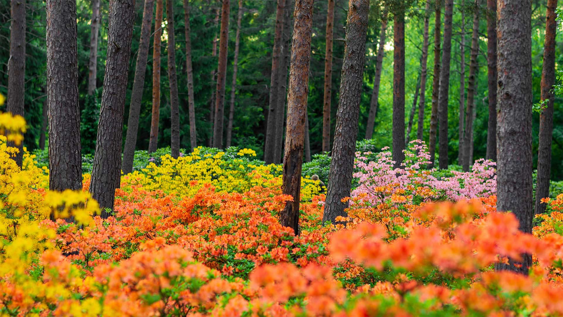
赫尔辛基的哈加杜鹃花公园,芬兰 Haaga Rhododendron Park, Helsinki, Finland (© Samuli Vainionpää/Getty Images)
赫尔辛基的哈加杜鹃花公园,芬兰 Haaga Rhododendron Park, Helsinki, Finland (© Samuli Vainionpää/Getty Images)
部分是科研园,部分是公园 Part science experiment, part public park
Haaga Rhododendron Park
In early June, if it's a 'good' year, people in Western Helsinki get treated to bursts of color at the Haaga Rhododendron Park. Started in 1975 as a research location for the University of Helsinki, the plan was to create rhododendron plants that would thrive in Finland's northern climate. And, boy, did they. Around 3,000 specimens of a Japanese variety of rhododendron were originally planted, then selectively bred to produce eight new varieties of 'rhodies' over the years.
In 1996, the park was expanded to include azalea plants which are in the same rhododendron family and bloom at the same time. The research garden now doubles as a public park that is visited by thousands of locals and tourists every summer. Since the gardens were originally planted, it's been observed that the blooms fluctuate. A vibrant year is usually followed by a more modest one. So, if you're 'rhodo-loco' and planning on making the trip to check it out, try to time it right.
哈加杜鹃公园
6月初,如果是“好”的一年,赫尔辛基西部的人们会在哈加杜鹃公园接受突发性的色彩治疗。1975年,作为赫尔辛基大学的研究基地,该计划旨在培育杜鹃花植物,使其在芬兰北部气候条件下茁壮成长。还有,孩子,他们做到了。最初种植了大约3000个日本杜鹃花品种的标本,然后经过多年的选择性培育,培育出8个新的“杜鹃花”品种。
1996年,公园扩建,包括杜鹃花植物,它们属于同一杜鹃科,同时开花。研究园现在兼作公共公园,每年夏天都有成千上万的当地人和游客参观。由于花园最初是种植的,人们观察到花期波动。充满活力的一年之后通常是较为温和的一年。因此,如果你是“rhodo loco”,并计划旅行去看看它,请尽量安排好时间。
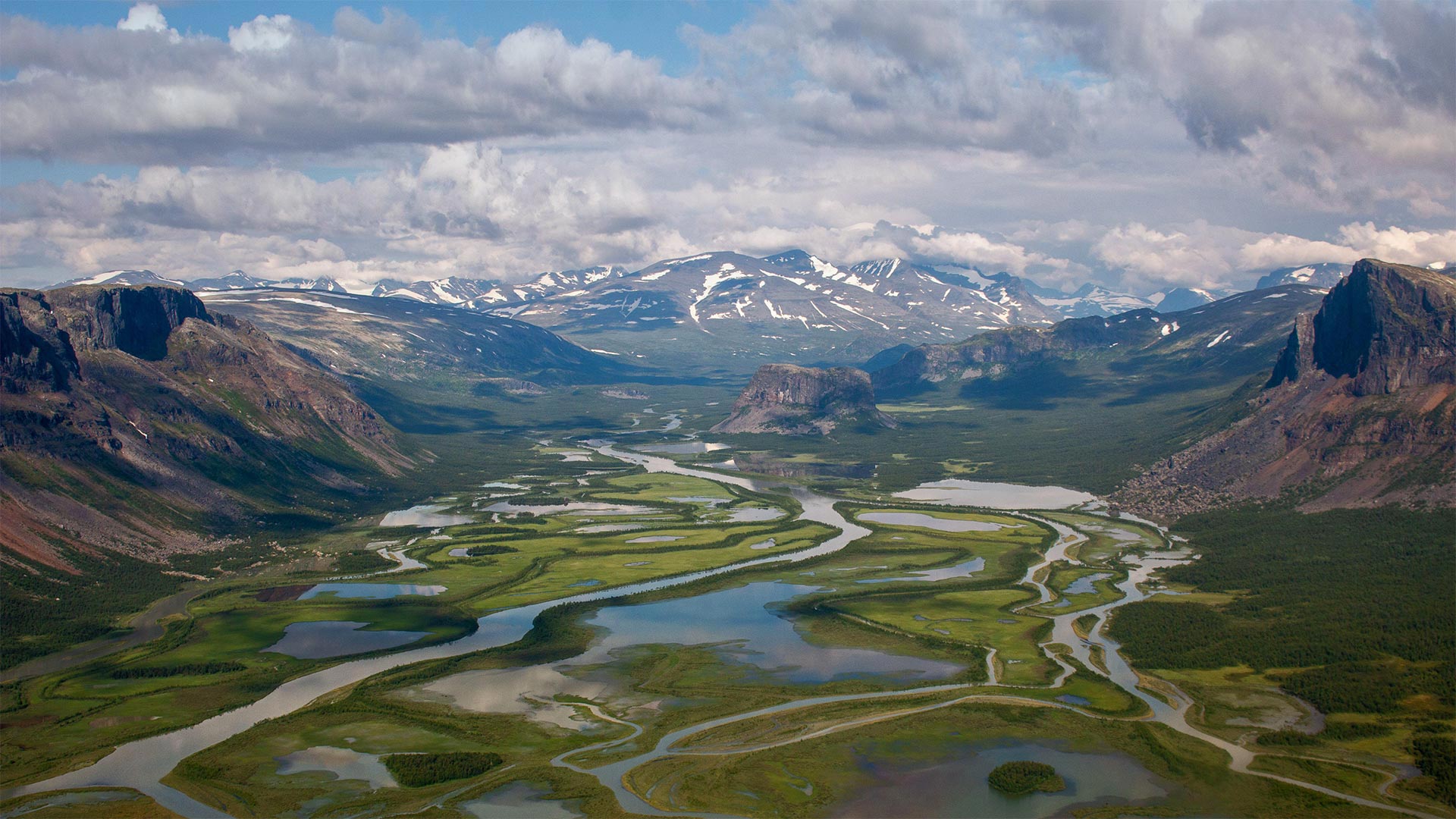
萨勒克国家公园的拉帕谷,瑞典 Rapa Valley in Sarek National Park, Sweden (© Alena Vishina/Alamy)
萨勒克国家公园的拉帕谷,瑞典 Rapa Valley in Sarek National Park, Sweden (© Alena Vishina/Alamy)
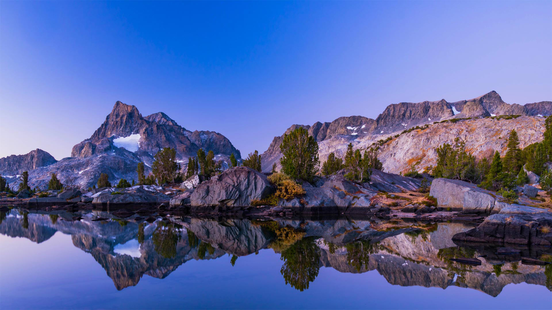
只有一个地球 'Only one Earth'
World Environment Day
Europe's oldest national park is a fitting place to contemplate nature's beauty on World Environment Day. Established in 1909, Sarek National Park encompasses 760 square miles of pristine wilderness in northern Sweden. Rapadalen (Rapa Valley), a 22-mile-long valley surrounded by steep mountains, is considered one of Europe's most enchanting landscapes. As beautiful as the remote, high-alpine region is, it is only recommended for experienced and well-equipped hikers. The weather is severe and unpredictable, and there are no accommodations available for tourists.
This year's theme for World Environment Day is 'Only One Earth,' a reprise of the theme from the UN's landmark Conference on the Environment held in Stockholm, which established World Environment Day 50 years ago, in 1972. What's the difference between Earth Day and World Environment Day? Not much! Both days celebrate our fragile planet and serve to motivate people to help preserve it. Earth Day started in 1970 on college campuses in the US, while World Environment Day was created by the United Nations with a goal to 'forge a basic, common outlook on how to address the challenge of preserving and enhancing the environment.' Hey, it's a big planet–there's more than enough room for two days to celebrate it.
世界环境日
欧洲最古老的国家公园是在世界环境日观想大自然之美的合适场所。萨瑞克国家公园建于1909年,占地760平方英里,位于瑞典北部的原始荒野中。拉帕达伦(RapaValley)是一个22英里长的山谷,四周环绕着陡峭的山脉,被认为是欧洲最迷人的景观之一。虽然偏远的高山地区很美丽,但它只推荐给有经验和装备精良的徒步旅行者。天气恶劣且不可预测,游客没有住宿。
今年世界环境日的主题是“只有一个地球”,这是联合国在斯德哥尔摩举行的具有里程碑意义的环境会议主题的翻版。50年前,斯德哥尔摩于1972年设立了世界环境日。地球日和世界环境日有什么区别?不多这两天都庆祝我们脆弱的星球,并激励人们帮助保护它。地球日始于1970年的美国大学校园,而世界环境日是由联合国创建的,目的是“就如何应对保护和改善环境的挑战形成一种基本的、共同的观点”嘿,这是一个大星球,有足够的空间庆祝两天。
安塞尔·亚当斯的荒野,加利福尼亚 View of Banner Peak from Thousand Island Pass, Ansel Adams Wilderness, California (© Michael DeYoung Photography/Tandem Stills + Motion)
安塞尔·亚当斯的荒野,加利福尼亚 View of Banner Peak from Thousand Island Pass, Ansel Adams Wilderness, California (© Michael DeYoung Photography/Tandem Stills + Motion)
前往山林,今天是国家步道日! Head for the hills, it's National Trails Day!
National Trails Day
Whether you're a leisurely day walker or a hardcore hiker, there's a US National Trail with your name on it. Thankfully the trails in the national network are categorized as 'Scenic,' 'Historic,' or 'Recreational' to simplify things. The most famous pathway is the Appalachian Trail ('Scenic'), which was the first to be officially named to the National Trails System when President Lyndon B. Johnson signed the system into law in 1968.
In a speech three years earlier, Johnson had said, 'We can and should have an abundance of trails for walking, cycling, and horseback riding, in and close to our cities. In the backcountry, we need to copy the great Appalachian Trail in all parts of America.' His vision took root, and today there are protected trails across the US, with much of their upkeep carried out by enthusiastic volunteers. If you need an incentive to hit the great outdoors, we reckon this image should do the trick. Banner Peak and Thousand Island Lake in the Ansel Adam Wilderness are highlighted along both the Pacific Crest Trail and the John Muir Trail.
Today is National Trails Day, established by the American Hiking Society as a day of public events aimed at advocacy and trail service. On this day, 'Thousands of hikers, bikers, rowers, horseback riders, trail clubs, federal and local agencies, land trusts, and businesses come together in partnership to advocate for, maintain, and clean up public lands and trails,' the AHS explains. The society aims to protect and enhance US National Trails for generations to come. A current focus is to make sure that trails are inclusive and accessible to everyone.
国家田径日
无论你是一个悠闲的日间旅行者还是一个铁杆徒步旅行者,都有一条美国国家小道,上面写着你的名字。谢天谢地,国家网络中的小径被归类为“风景区”、“历史区”或“休闲区”,以简化事情。最著名的路径是阿巴拉契亚小径(“风景区”),这是1968年林登·B·约翰逊总统将国家小径系统签署为法律时,第一条正式命名为国家小径系统的路径。
在三年前的一次演讲中,约翰逊曾说过:“我们可以而且应该在我们的城市内和附近有大量的小径,可以步行、骑自行车和骑马。”。在偏远地区,我们需要复制美国各地的阿巴拉契亚山脉他的愿景扎根于此,如今,美国各地都有受保护的小径,它们的大部分维护工作都是由热情的志愿者完成的。如果你需要一个动机去户外旅行,我们认为这张图片应该能起到作用。安塞尔亚当荒野中的旗帜峰和千岛湖沿着太平洋顶峰小径和约翰·缪尔小径突出显示。
今天是国家徒步日,由美国徒步旅行协会设立,作为公共活动日,旨在宣传和提供徒步服务。AHS解释说,在这一天,“数千名徒步旅行者、自行车手、划船手、马背骑手、小道俱乐部、联邦和地方机构、土地信托基金和企业携手合作,倡导、维护和清理公共土地和小道。”。该协会旨在为子孙后代保护和加强美国国家步道。当前的一个重点是确保所有人都能访问到包含在内的轨迹。
广角镜头下的厦门龙舟池,日落的光洒在传统龙舟上,中国 Wide angle view of the sunset landscapes in Longzhou Lake with traditional Dragon boats in front in Xiamen, China (© Sen Li/Getty Image)
广角镜头下的厦门龙舟池,日落的光洒在传统龙舟上,中国 Wide angle view of the sunset landscapes in Longzhou Lake with traditional Dragon boats in front in Xiamen, China (© Sen Li/Getty Image)
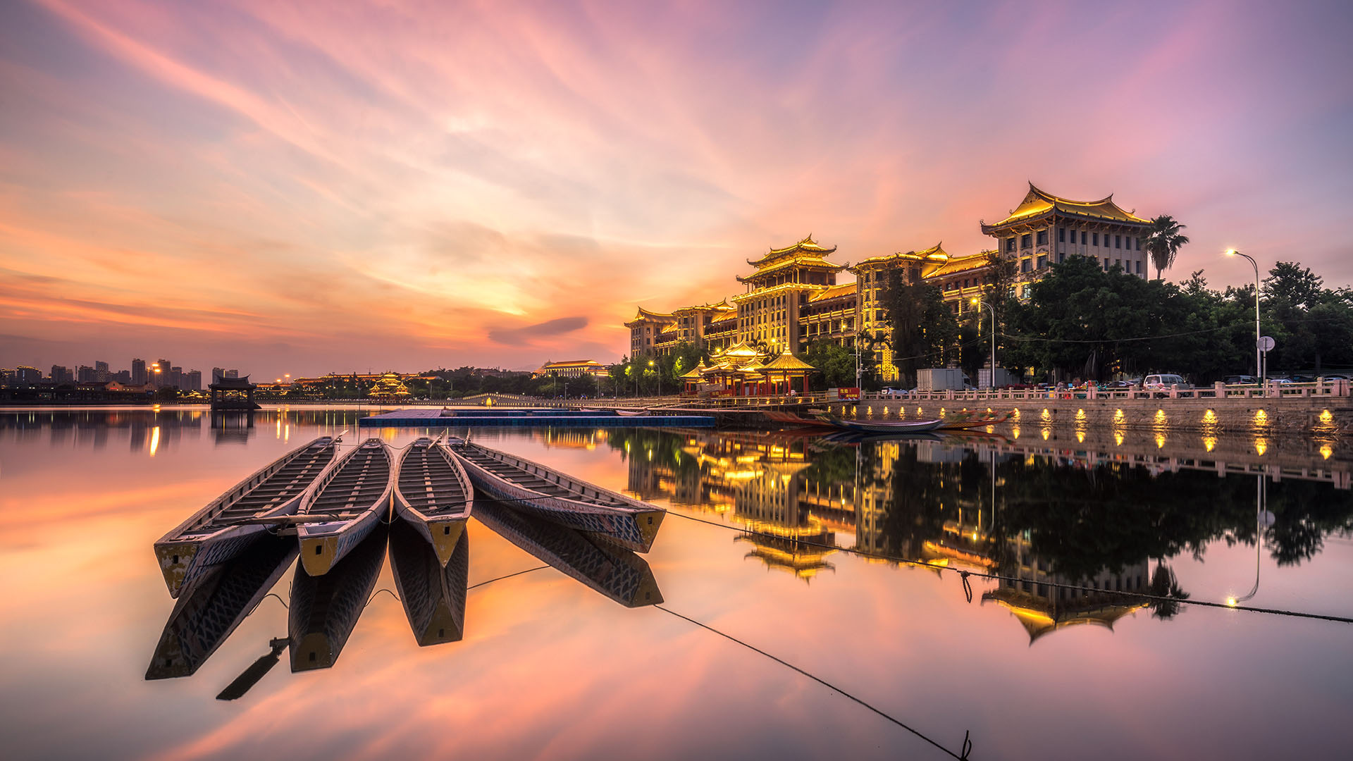
端午节安康 Safe and Healthy Dragon Boat Festival
Dragon Boat for the Festival, Xiamen
Among the legends about the origins of the Dragon Boat Festival, the most popular one is in commemoration of Qu Yuan. The great poet drowned himself in the Miluo River, from then on the locals would beat drums and rowboats on the river on this day, and put zongzi in the river in order to keep the fish and evil spirits away from his body.
端午节,厦门
在关于端午节起源的传说中,最流行的是纪念屈原。这位伟大的诗人在汨罗江中溺水自尽,从那时起,当地人会在这一天在河上击鼓划船,并把粽子放在河里,以防鱼和恶魔远离他的身体。
白金汉宫, 英国伦敦 Buckingham Palace in London, England (© Pajor Pawel/Shutterstock)
白金汉宫, 英国伦敦 Buckingham Palace in London, England (© Pajor Pawel/Shutterstock)
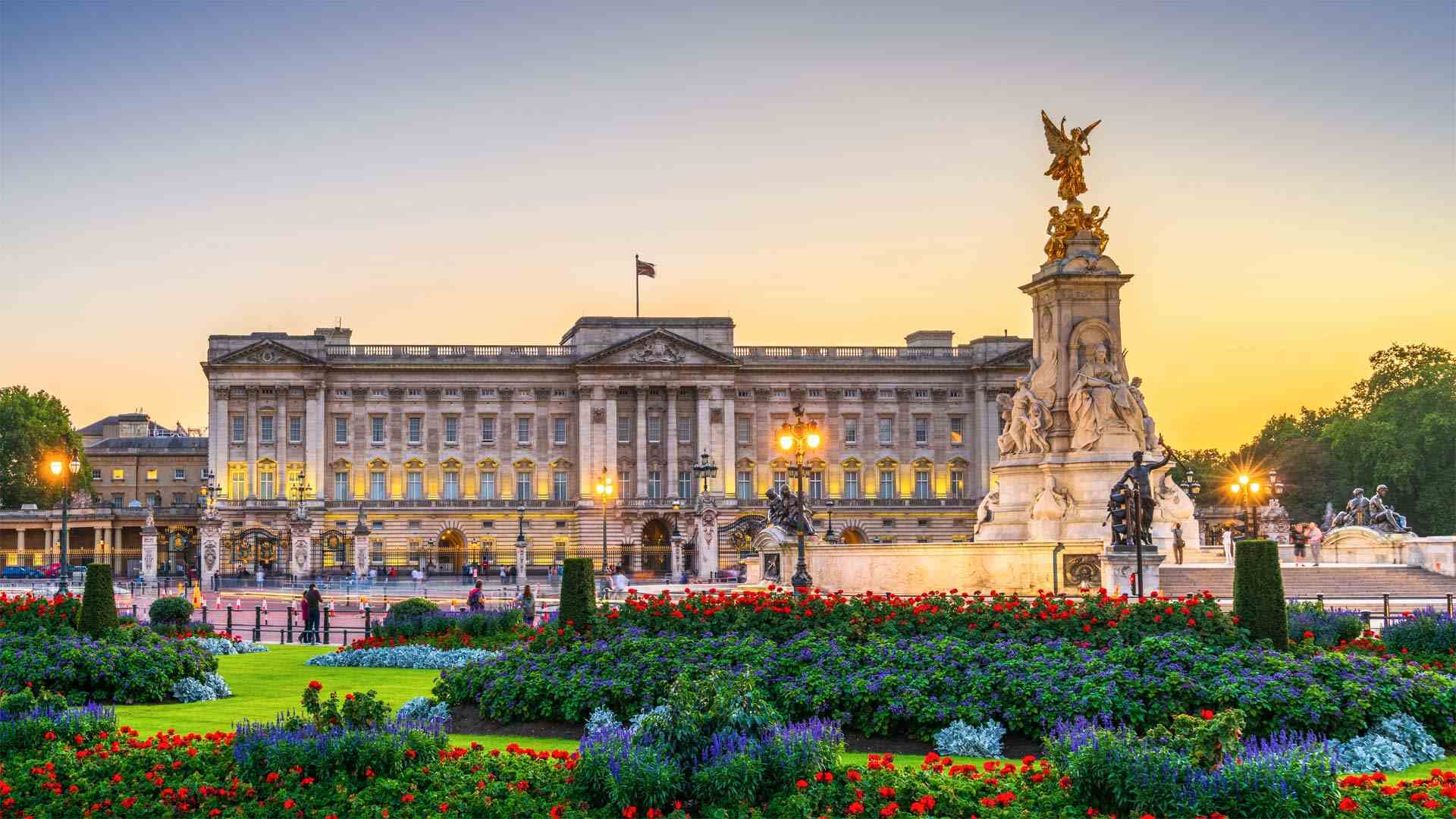
白金禧年庆典 Platinum Jubilee celebrations
Buckingham Palace in London
Any royal watcher will tell you that the Brits know how to throw a good party. For Queen Elizabeth II's platinum jubilee—she's been monarch for an amazing 70 years—a slew of events are planned, hitting all the notes from pomp and ceremony to picnics on the village green. Of course, the Trooping of the Colour will take center stage today as the official birthday parade, with 1,400 soldiers in full military regalia, 200 horses, and 400 military band musicians. The royal family will watch the parade and then turn their gaze to the skies as the Royal Air Force flies past. The rest of the jubilee week will include a service of Thanksgiving at St. Paul's Cathedral in London, a live concert here at Buckingham Palace, and a special pageant featuring people from throughout Britain.
Locally, beacons will be lighted the length of the land, and we can't deny that we're excited about a nationwide baking contest to discover a new dessert fit for the queen. Another delicious way to celebrate the jubilee is with the Big Lunch. The idea took off in 2009 and is now a beloved annual tradition. Communities get together to celebrate and enjoy themselves, sharing food and friendship in gatherings large and small. The lunch can be a neighborhood barbecue or a street party—or even an impromptu wine-and-cheese affair, with people sitting on folding chairs in someone's driveway. While no one really needs an excuse to show their national pride, a platinum jubilee is quite a remarkable reason to celebrate.
伦敦白金汉宫
任何一位皇家观察家都会告诉你,英国人知道如何举办一个好的派对。伊丽莎白女王二世(Queen Elizabeth II)的白金周年纪念日,她担任国王长达70年之久,计划举办一系列活动,从盛大的仪式到乡村绿地上的野餐,无不引人注目。当然,今天的官方生日阅兵式将以彩色骑兵为中心,1400名士兵身着华丽的军装,200匹马,400名军乐团音乐家。王室将观看阅兵式,然后在皇家空军飞过时将目光投向天空。庆祝周的其余时间将包括在伦敦圣保罗大教堂举行的感恩节仪式、在白金汉宫举行的现场音乐会,以及由来自英国各地的人们参加的特别盛会。
在当地,灯塔将照亮整个土地,我们不能否认,我们对全国范围的烘焙比赛感到兴奋,以发现适合女王的新甜点。庆祝禧年的另一种美味方式是丰盛的午餐。这个想法在2009年开始流行,现在已成为备受喜爱的年度传统。社区聚在一起庆祝和享受,在大大小小的聚会中分享食物和友谊。午餐可以是邻居的烧烤或街头派对,甚至是即兴的葡萄酒和奶酪聚会,人们坐在某人车道上的折叠椅上。虽然没有人真的需要一个借口来表达他们的民族自豪感,但白金禧年是值得庆祝的一个非凡理由。
福森市的莱西瀑布,德国拜仁州 (© Sergej Razvod/agefotostock)
马罗沃泻湖中的珊瑚礁,所罗门群岛 Coral reef in Marovo Lagoon in the Solomon Islands (© WaterFrame/Alamy)
马罗沃泻湖中的珊瑚礁,所罗门群岛 Coral reef in Marovo Lagoon in the Solomon Islands (© WaterFrame/Alamy)
水下的奇妙景观 The beauty that lies below
World Reef Day
The Marovo Lagoon in the Solomon Islands is the largest saltwater lagoon in the world. Protected by a double barrier reef, it's home to unique marine life and coral, making it a bucket-list destination for divers. The beauty and diversity of life contained within its pristine, 270 square miles are the perfect inspiration for World Reef Day, observed every year on June 1 to bring awareness to this vital but largely unseen part of our natural world. Reef Day also kicks off World Oceans Month, a time to celebrate and learn more about these vital ecosystems.
Although coral reefs occupy less than 0.1% of the planet's oceans, they support up to 25% of the world's marine species. They have rightfully earned their nickname, 'Rainforests of the Sea.' Coral is not a plant, but part animal and part mineral, a marine invertebrate that secretes calcium carbonate to form a hard skeleton. They grow in colonies, usually in warm, shallow waters, and form vast colonies that we see as reefs, providing the basic platform for marine life to flourish around them. They even provide benefits to land, protecting shorelines from the forces of the ocean.
Unfortunately, coral reefs are under immense environmental pressure due to pollution, overfishing, and particularly from changing ocean temperatures. A warming ocean and acidification due to increased carbon dioxide have resulted in coral bleaching—when under stress, corals lose their color. The yellow whip and red gorgonian you see here are what healthy corals look like, but vibrant, hearty corals are swiftly becoming the exception rather than the rule. Recently, even the previously robust and thriving Marovo Lagoon began showing signs of bleaching, a sobering reminder that the beauty we see here is fragile and becoming more precious.
世界珊瑚礁日
所罗门群岛的马罗沃泻湖是世界上最大的咸水泻湖。受双堡礁保护,这里是独特海洋生物和珊瑚的家园,是潜水员的首选目的地。每年6月1日是世界珊瑚礁日,每年的6月1日是世界珊瑚礁日的纪念日,旨在让人们认识到这一自然世界中重要但基本上看不见的部分,其270平方英里的原貌中蕴含着美丽而多样的生命。珊瑚礁日也是世界海洋月的开始,是庆祝和了解这些重要生态系统的时候。
虽然珊瑚礁只占地球海洋的不到0.1%,但它们支持着世界上多达25%的海洋物种。他们理所当然地赢得了“海洋雨林”的绰号珊瑚不是植物,但部分是动物,部分是矿物,是一种海洋无脊椎动物,分泌碳酸钙形成坚硬的骨架。它们通常生长在温暖的浅水区,形成巨大的珊瑚礁群,为海洋生物在其周围繁衍生息提供了基本平台。它们甚至为陆地带来好处,保护海岸线不受海洋力量的影响。
不幸的是,由于污染、过度捕捞,尤其是海洋温度的变化,珊瑚礁面临着巨大的环境压力。海洋变暖和二氧化碳增加导致的酸化导致珊瑚白化。在压力下,珊瑚会失去颜色。你在这里看到的黄色鞭子和红色gorgonian珊瑚是健康的珊瑚的样子,但充满活力、饱满的珊瑚很快就会成为例外,而不是常规。最近,就连之前繁荣的马洛沃环礁湖也开始出现白化迹象,这提醒我们,我们在这里看到的美丽是脆弱的,越来越珍贵。
日落时分的阿萨巴斯卡瀑布,加拿大 Sunset lights up Mount Fryatt as the Athabasca River flows over Athabasca Falls in Jasper National Park, Alberta, Canada (© Robert Postma/Getty Images)
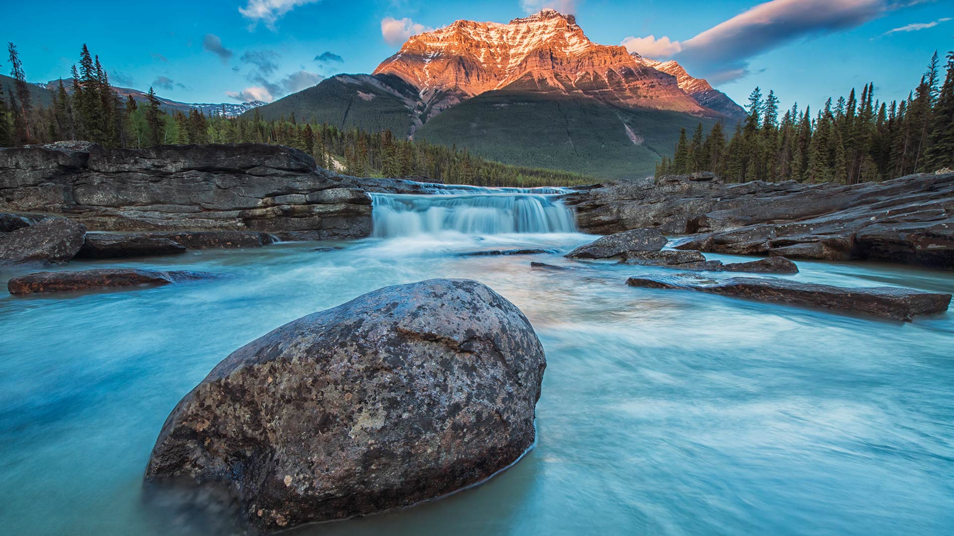
日落时分的阿萨巴斯卡瀑布,加拿大 Sunset lights up Mount Fryatt as the Athabasca River flows over Athabasca Falls in Jasper National Park, Alberta, Canada (© Robert Postma/Getty Images)
奔腾不息的自然力量 Small but mighty
Athabasca Falls in Jasper National Park
Athabasca Falls is one of the most striking waterfalls on the Icefields Parkway, and a visit to Jasper National Park in Alberta wouldn't be complete without it. Despite its low height of just 23 meters, the incredible volume and intensity of the falls make it a renowned gem of the Canadian Rockies. The falls are fed with pristine water flowing from the Columbia Icefield glaciers and snowmelt from neighboring mountains. Mount Fryatt makes for the perfect backdrop with its horn-shaped summit; a result of being carved and sculpted by glaciers from all angles over the years. Mount Fryatt consists of sedimentary rocks deposited from the Precambrian to Jurassic eras.
贾斯珀国家公园阿萨巴斯卡瀑布
阿萨巴斯卡瀑布是冰原公园路上最引人注目的瀑布之一,没有它,参观亚伯达省的贾斯珀国家公园就不算完整。尽管它的低高度只有23米,但令人难以置信的瀑布体积和强度使它成为加拿大落基山脉著名的宝石。这些瀑布由哥伦比亚冰原冰川流出的纯净水和邻近山脉的融雪补给。弗赖亚特山以其喇叭形的山顶成为完美的背景;这是多年来冰川从各个角度雕刻的结果。Fryatt山由前寒武纪至侏罗纪沉积岩组成。