标签 湖 下的文章
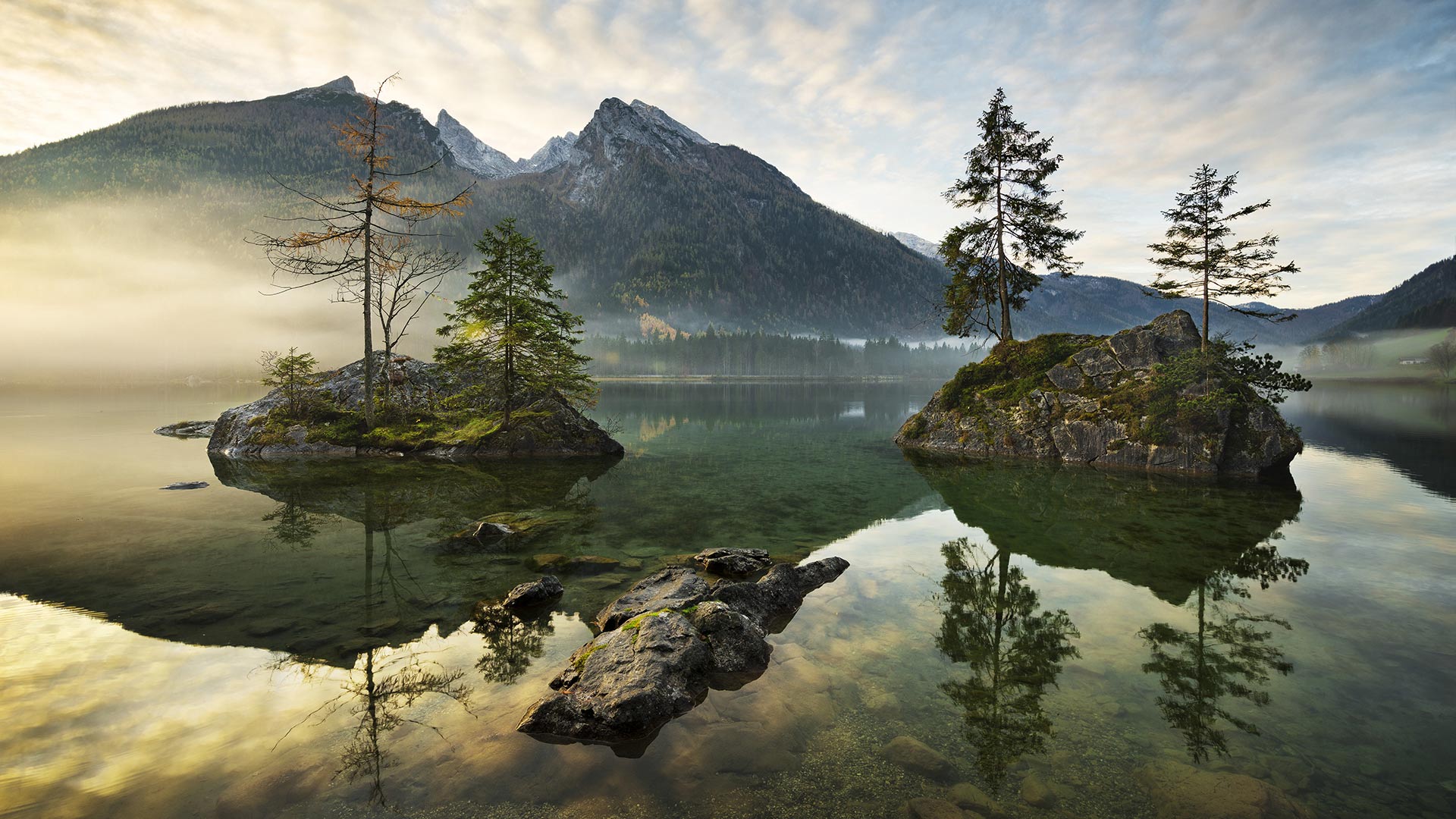
冬日里的科赫尔湖,德国巴伐利亚州 Kochelsee and Heimgarten Mountain in Bavaria, Germany (© Reinhard Schmid/eStock Photo)
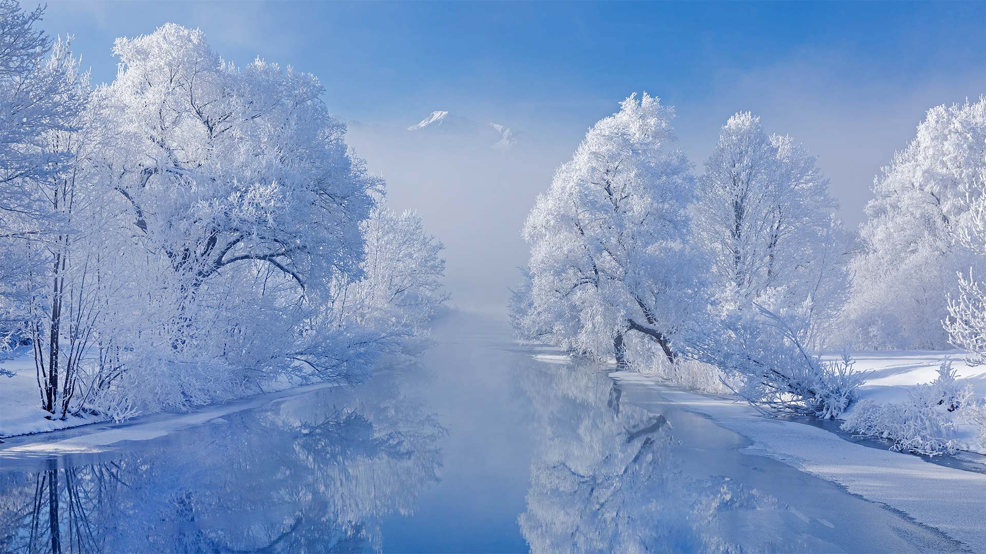
冬日里的科赫尔湖,德国巴伐利亚州 Kochelsee and Heimgarten Mountain in Bavaria, Germany (© Reinhard Schmid/eStock Photo)
Kochelsee in Bavaria
To English speakers, this is Lake Kochel. To German speakers, it's Kochelsee. Whatever you call it, this popular recreation spot in Bavaria looks great all decked out in winter white. Imagine how quiet it must be when the lake is blanketed by snow. Now stretch your imagination further to the warm summer months when the shores of Kochelsee are busy with tourists out to get a dose of nature. The lake is just an hour's journey by car or train, south from the Munich. Visit during summer and you're likely to see windsurfers gliding across the surface of the lake.
巴伐利亚州的科切西
对说英语的人来说,这是科切尔湖。对说德语的人来说,这是科切西。不管你怎么称呼它,这个巴伐利亚州广受欢迎的娱乐场所穿上冬装,看起来很棒。想象一下,当湖面被雪覆盖时,一定是多么安静。现在,让你的想象力进一步延伸到温暖的夏季,科切西海岸正忙于吸引游客到这里来体验大自然。从慕尼黑以南,乘汽车或火车到这个湖只有一个小时的路程。夏季游览,你可能会看到风帆冲浪者滑过湖面。
湖畔的一棵小圣诞树,奥地利魏森湖 Holiday tree at Weissensee, a small lake near Ehrwald in Tyrol, Austria (© nagelestock/Alamy)
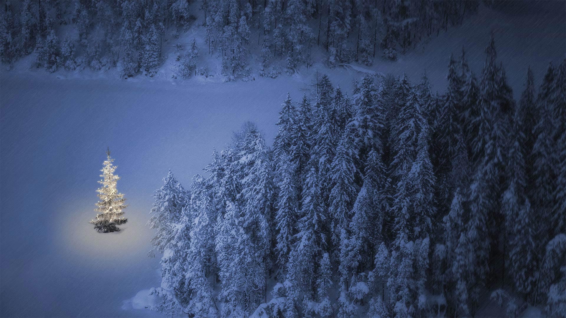
湖畔的一棵小圣诞树,奥地利魏森湖 Holiday tree at Weissensee, a small lake near Ehrwald in Tyrol, Austria (© nagelestock/Alamy)
'Smoking nights' in Austria
Behold the lovely Tannenbaum ('fir tree' for you non-German speakers). Here in Tyrol, Austria, Christmas Eve marks the first of three Rauchnächte, or 'smoking nights.' A long-standing Tyrolean tradition, people in this Alpine region burn frankincense and herbs in homes, barns, and stables to avert bad fortune. The custom is then repeated on the other two 'smoking nights,' New Year's Eve and the night before Epiphany.
It's said that everything that happens on these nights is of great significance, including one's dreams. Whatever you dream on smoking nights is thought to be a message from above foretelling what the next year may bring. Pardon us while we drift off to the holiday carol 'O Tannenbaum,' currently playing in our heads. Sweet dreams!
奥地利的“吸烟之夜”
看看可爱的坦嫩鲍姆(“冷杉树”适合非德语人士)。在奥地利的蒂罗尔,平安夜是三个“吸烟之夜”中的第一个这个阿尔卑斯地区的人们在家里、谷仓和马厩里燃烧乳香和草药以避免厄运,这是一个由来已久的蒂罗尔传统。这一习俗随后在另外两个“吸烟之夜”——除夕夜和主显节前一晚重复。
据说,在这些夜晚发生的一切都具有重大意义,包括一个人的梦想。无论你在吸烟之夜做什么梦,都被认为是来自上面的信息,预示着明年会发生什么。请原谅,当我们去度假的时候,卡罗尔·奥·塔南鲍姆正在我们的脑海中演奏。甜美的梦!
阿尔高阿尔卑斯山脉的Schrecksee湖,德国巴伐利亚 Lake Schrecksee in the Allgäu Alps, Bavaria, Germany (© Andreas Hagspiel/EyeEm/Getty Images)
阿尔高阿尔卑斯山脉的Schrecksee湖,德国巴伐利亚 Lake Schrecksee in the Allgäu Alps, Bavaria, Germany (© Andreas Hagspiel/EyeEm/Getty Images)
The picturesque lake in the Allgäu high Alps
The Schrecksee in the Allgäu High Alps has the reputation among mountain hikers as being the most beautiful mountain lake in the Alps. We don't want to commit ourselves, but given this magnificent record, it's undeniable that he's definitely making it into the top 10. The picturesque mountain lake lies at 1,813 metres in a cauldron-like high valley, surrounded by six Allgäu mountain peaks called Knappenkopf, Kirchendach, Kälbelespitze, Kastenkopf, Lahnerkopf and Älpelekopf.
The ascent to the Schrecksee takes about three hours from Bad Hindelang in the Oberallgäu. A good basic level of fitness is a prerequisite for almost 1,000 meters of altitude. There is a good chance of encountering marmots and eagles along the way. And those who are not sensitive to the cold can take a refreshing swim in the idyllic lake after the strenuous ascent. This is probably why the Schrecksee got its name because its water is still shockingly cold even in midsummer.
阿尔高阿尔卑斯山风景如画的山湖
阿尔高阿尔卑斯山的Schrecksee湖被登山者誉为阿尔卑斯山上最美丽的山湖。我们不想作出承诺,但鉴于这一辉煌的记录,不可否认的是,他肯定会进入前10名。风景如画的山湖位于1813米处,坐落在一个像釜一样的高山谷中,周围环绕着六个山谷Knappenkopf, Kirchendach, Kälbelespitze, Kastenkopf, Lahnerkopf和Älpelekopf。
从奥伯拉格的巴德后德兰到施雷克西大约需要三个小时,良好的基本身体素质是海拔近1000米的先决条件。沿途很有可能遇到土拨鼠和老鹰。而那些对寒冷不敏感的人,可以在艰苦的攀登之后,在田园诗般的湖中畅游一番。这可能就是为什么Schrecksee的名字,因为它的水仍然令人震惊的冷,即使在仲夏。
鸟瞰皮纳图博火山湖和山脉,菲律宾波拉克 Aerial view of volcanic Lake Pinatubo and mountains, Porac, Philippines (© Amazing Aerial Agency/Offset by Shutterstock)
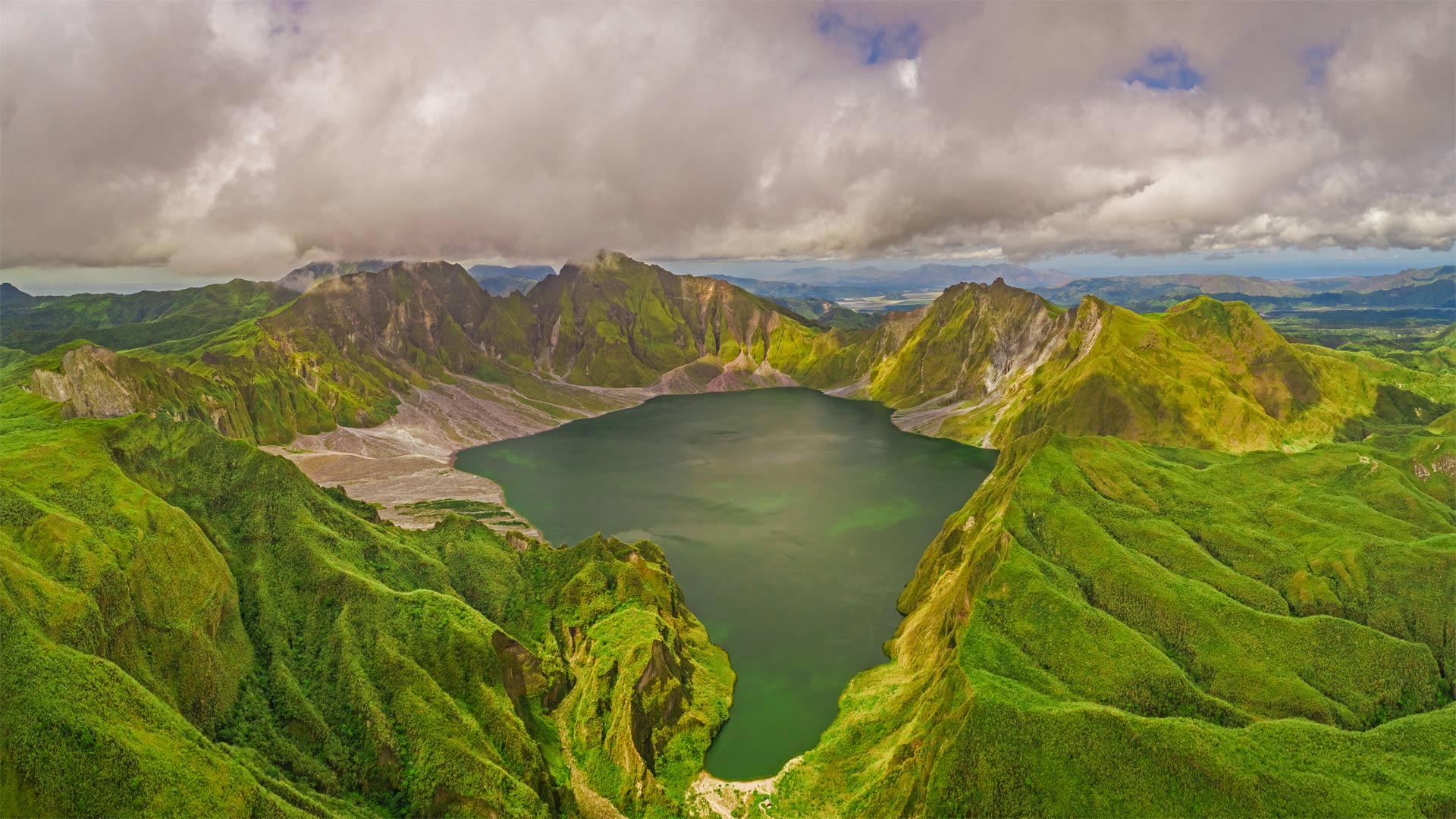
鸟瞰皮纳图博火山湖和山脉,菲律宾波拉克 Aerial view of volcanic Lake Pinatubo and mountains, Porac, Philippines (© Amazing Aerial Agency/Offset by Shutterstock)
Are you older than this lake?
If you were born before summer 1991, the answer is yes. Sorry if you already felt a bit long in the tooth, but it's true: Before 30 years ago, Lake Pinatubo was just a rumble in Mount Pinatubo's magma-filled belly. It was a calamitous eruption on June 15, 1991—one of the 20th century's most powerful—that blew off Pinatubo's original summit and formed a vast crater, which gradually filled with water as greenery reclaimed the summit.
Located about 50 miles from the Philippines' capital of Manila, the crater was for many years a niche destination for hardy hikers, requiring days of travel to reach. More recently, a 4x4 road and tended hiking trail were added, reducing the rugged journey to a day trip.
你比这个湖大吗?
如果你出生在1991年夏天之前,答案是肯定的。抱歉,如果你已经觉得牙齿有点长了,但这是真的:30年前,皮纳图博湖只是皮纳图博火山充满岩浆的肚子里的隆隆声。这是1991年6月15日的一次灾难性喷发,是20世纪最强大的喷发之一,它把皮纳图博最初的山顶吹走,形成了一个巨大的火山口,随着绿色植物对山顶的再生,火山口逐渐充满了水。
这个陨石坑距离菲律宾首都马尼拉大约50英里,多年来一直是耐寒徒步旅行者的利基目的地,需要数天的旅行才能到达。最近,增加了一条4x4公路和徒步小径,将崎岖的旅程缩短为一日游。
加拿大亚伯达省贾斯珀国家公园马利尼湖的精神岛 Spirit Island in Maligne Lake, Jasper National Park, Alberta, Canada (© Jeff Penner/EyeEm/Getty Images)
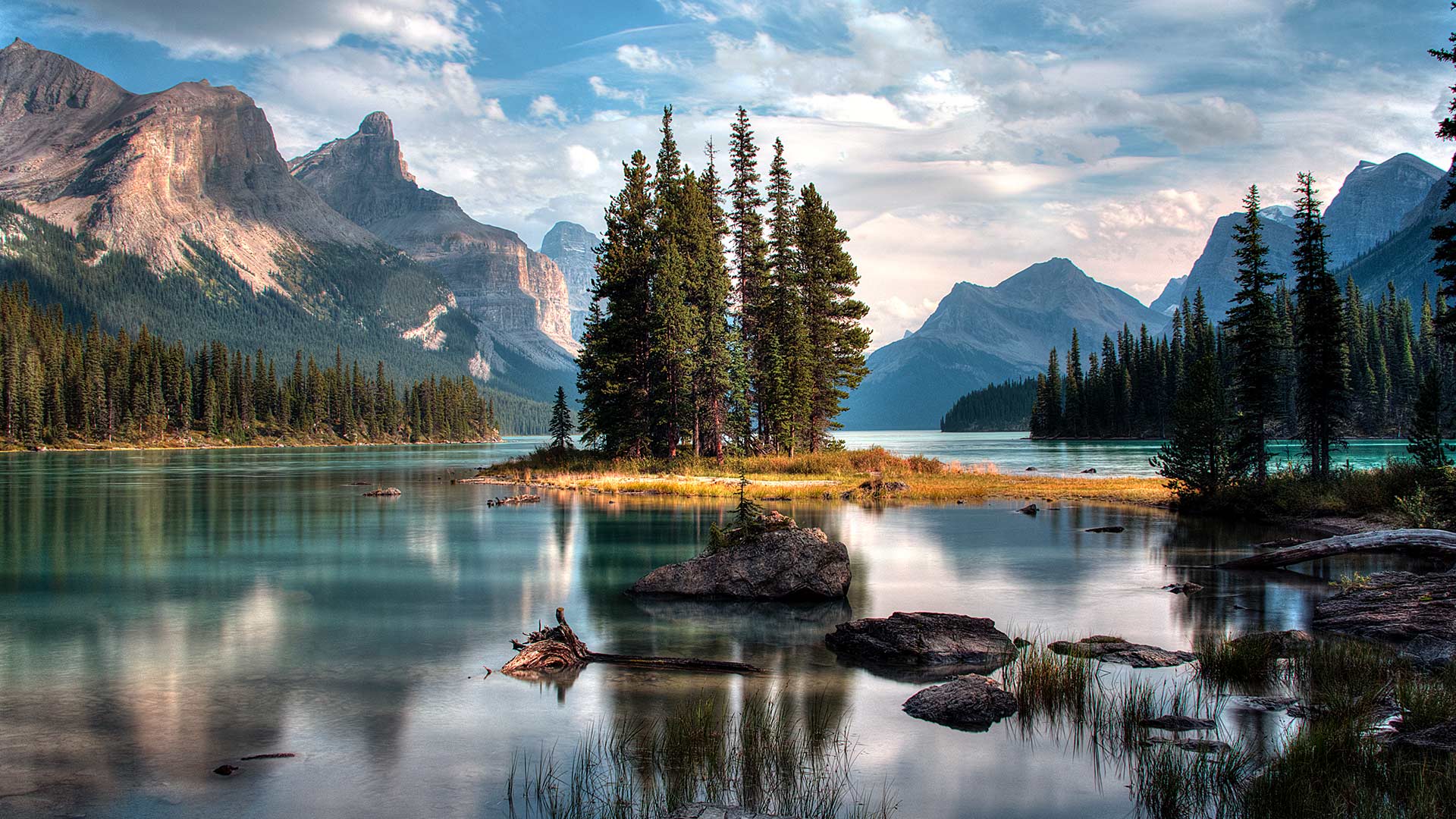
Spirit Island in Maligne Lake, Jasper National Park, Alberta, Canada (© Jeff Penner/EyeEm/Getty Images)
A photographer's paradise
If you are dreaming of an escape to paradise, look no further. Welcome to one of the most photographed sites in the majestic Canadian Rockies. Located in Jasper National Park in Alberta, the scenic Maligne Lake is 22 kilometres long, making it the largest natural lake out here. In the middle of this lake, sits the iconic Spirit Island which is only accessible via tour boats or private boats. The glacial, azure-blue waters, pine trees and snow-capped peaks frame Spirit Island, epitomizing the beauty of Jasper. In addition to admiring the natural beauty here, visitors can engage in activities such as hiking, fishing and kayaking during summer and skiing and snowshoeing in the winter.
摄影师的天堂
如果你梦想着逃往天堂,不要再看了。欢迎来到雄伟的加拿大落基山脉最受欢迎的景点之一。位于艾伯塔省贾斯珀国家公园,风景秀丽的马林湖长22公里,是这里最大的天然湖泊。在这个湖的中央,坐落着标志性的精神岛,只有通过旅游船或私人船只才能到达。冰川、湛蓝的海水、松树和白雪皑皑的山峰构成了精灵岛,是碧玉之美的缩影。除了欣赏这里的自然美景外,游客还可以在夏季进行徒步旅行、钓鱼和皮划艇活动,在冬季进行滑雪和雪鞋运动。
格伦·埃蒂夫盛开着石南花的小湖,苏格兰 Small loch in Glen Etive, Scotland (© Oliver Hellowell/Minden Pictures)
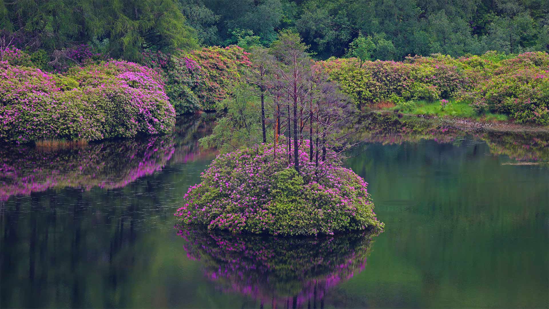
格伦·埃蒂夫盛开着石南花的小湖,苏格兰 Small loch in Glen Etive, Scotland (© Oliver Hellowell/Minden Pictures)
An island in the Highlands
Here in the Scottish Highlands, there's something about the rugged environs of Glen Etive that has tickled the imaginations of both ancient and modern storytellers. A glen is a long, narrow valley and this one is especially beautiful. It has strange footnotes in both Irish and Scottish folklore. The name itself translates to 'little fierce one' and is given in honor of Etive, the Gaelic goddess long associated with nearby Loch Etive.
According to an Irish myth, Glen Etive was founded by the tragic heroine Deirdre and her lover Naoise after they were forced into exile. In Scottish folklore, Glen Etive is said to be the home of a mythical creature called a Fachan--a giant cyclops with one leg, a single tuft of hair, and a lone hand protruding from its chest. Glen Etive has caught the attention of modern storytellers as well, drawn to its history and beautiful scenery. A surprising number of TV shows and major films, like 'Braveheart' and the James Bond installment 'Skyfall,' have shot on location here.
Glen Etive is also one of Scotland's 40 National Scenic Areas, and is a favorite destination for white water kayakers, who journey here to shoot down the series of rapids, falls, and pool drops along the River Etive. Hikers trek the mountain trails around Ben Starav to the southeast and the Glen Coe mountains in the north. Some of these of hikers are known as 'peak baggers,' who make it a game to summit every peak in the region. So far, about 4,000 or so people have completed the entire list of 284 Scottish peaks, or 'munros' as they're known locally.
高地上的一个岛屿
在苏格兰高地,格伦艾蒂夫崎岖的环境激发了古代和现代说书人的想象力。峡谷是一个又长又窄的山谷,这个山谷特别美丽。它在爱尔兰和苏格兰民间传说中都有奇怪的脚注。这个名字本身翻译成“小凶猛的一个”,是为了纪念艾蒂芙,长期以来与附近的艾蒂芙湖联系在一起的盖尔女神。
根据一个爱尔兰神话,格伦·艾蒂夫是由悲剧女主角迪尔德雷和她的情人娜奥伊丝在被迫流亡后建立的。在苏格兰民间传说中,格伦埃蒂夫据说是一种神话生物法坎的家——一只巨大的独眼巨人,一条腿,一簇头发,一只手从胸前伸出。格伦艾蒂夫吸引了现代说书人的注意,也被它的历史和美丽的风景所吸引。很多电视节目和主要电影,如《勇敢的心》和詹姆斯·邦德的《天崩地裂》都在这里拍摄。
格伦艾蒂夫也是苏格兰40个国家级风景区之一,也是白水皮划艇运动员最喜欢的目的地,他们在这里沿着艾蒂夫河击落一系列急流、瀑布和池水。徒步旅行者沿着本斯塔拉夫周围的山路跋涉到东南部和北部的格伦科山脉。其中一些徒步旅行者被称为“峰袋客”,他们把登上该地区的每一座山峰当作游戏。到目前为止,大约有4000人已经完成了284座苏格兰山峰的完整列表,也就是当地人所熟知的“munros”。
巴特米尔湖上的落日 ,英格兰湖区 (© Stewart Smith/Alamy)
格林内尔湖,蒙大拿州冰川国家公园 Grinnell Lake, Glacier National Park, Montana (© Pung/Shutterstock)
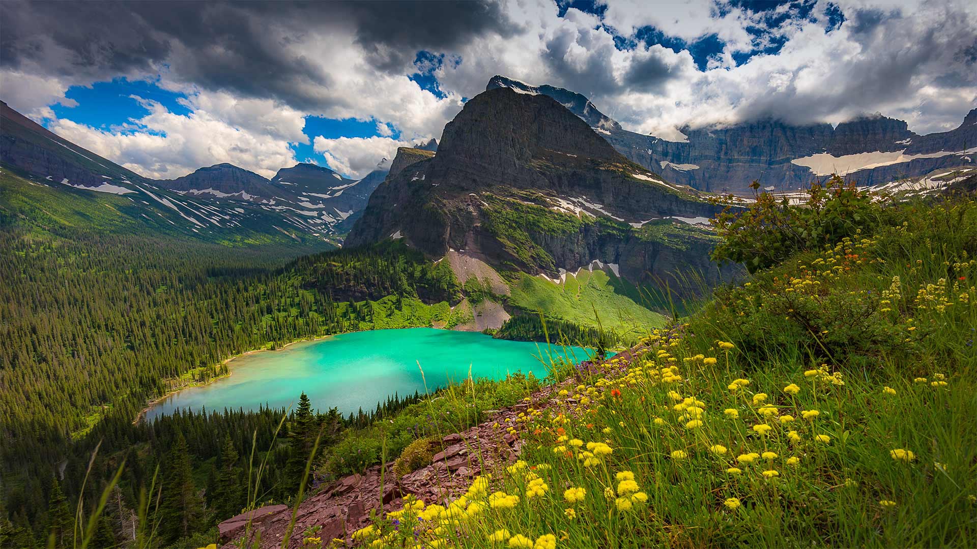
格林内尔湖,蒙大拿州冰川国家公园 Grinnell Lake, Glacier National Park, Montana (© Pung/Shutterstock)
'The Crown of the Continent'
With one million acres of rugged, northwestern Montana wilderness to explore, a trip to Glacier National Park could fill up an entire summer and more. But let's just take one day and virtually visit Grinnell Lake. A 7-mile loop trail, a relatively easy one in this rugged country, takes you to the shores of the lake turned emerald-green by glacial silt. Grinnell Lake—as well as Mount Grinnell and Grinnell Glacier—is named for the naturalist and Audubon Society founder George Bird Grinnell. For two decades, he lobbied for the creation of the park, and on May 11, 1910, the 'Crown of the Continent,' as Grinnell dubbed this area, became the nation's 10th national park.
“大陆之冠”
有一百万英亩崎岖不平的蒙大拿州西北部荒野可供探索,一次冰川国家公园之旅可能会填满整个夏天,甚至更多。但让我们花一天时间去参观格林内尔湖吧。在这个崎岖的国家,一条7英里长的环形小径相对容易,它会带你到达湖岸,湖岸被冰川淤泥染成翠绿。格林内尔湖以及格林内尔山和格林内尔冰川是以博物学家和奥杜邦协会创始人乔治·伯德·格林内尔命名的。二十年来,他一直在游说建立这个国家公园,1910年5月11日,格林内尔称之为“欧洲大陆之冠”的这个地区成为美国第十个国家公园。
被阿尔卑斯山环抱的辛特湖,德国贝希特斯加登 Lake Hintersee surrounded by alpine mountains, Berchtesgaden, Bavaria, Germany (© Offset by Shutterstock)
被阿尔卑斯山环抱的辛特湖,德国贝希特斯加登 Lake Hintersee surrounded by alpine mountains, Berchtesgaden, Bavaria, Germany (© Offset by Shutterstock)
A walk by the lake
Surrounded by gigantic peaks and located in Ramsau at the foot of the Reiter-Alm, Hintersee Lake has fascinated many landscape artists and poets.
The most beautiful footpath to the lake leads from Ramsau through the Zauberwald (Enchanted Forest), and along a wild mountain stream. Take a walk on the theme trail leading around the lake and presenting information on the romantic-period painters of the 19th century. The lake has provided the setting for many an Alpine movie.
在湖边散步
位于雷特阿尔姆山脚下的拉姆索,因特塞湖被巨大的山峰环绕,吸引了许多风景艺术家和诗人。
通往湖边最美丽的小径是从拉姆索穿过扎乌伯瓦尔德(魔法森林),沿着一条荒野的山涧。在主题小径上漫步,沿湖漫步,介绍19世纪浪漫主义时期画家的信息。这个湖为许多阿尔卑斯山电影提供了背景。
火山口湖,俄勒冈州 Crater Lake in Oregon (© Steve Bloom Images/Alamy)
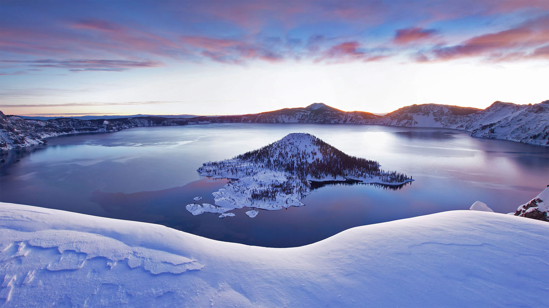
火山口湖,俄勒冈州 Crater Lake in Oregon (© Steve Bloom Images/Alamy)
Travels to the Oregon deep
We're looking out on the deepest lake in the US. Crater Lake, the centerpiece and namesake of the only national park in Oregon, goes down to depths of 1,943 feet—that's enough room to stack three-and-a-half Washington Monuments end to end. Fed mainly by snowfall, this pristine, crystal blue lake came into this world with a bang. Sometime around 5700 BCE, Mount Mazama erupted, losing roughly 3,000 feet of its height. The volcano blew out so much molten rock that it left a giant depression that gradually filled with water, giving us this serene scene today.
Crater Lake National Park is open to visitors year-round, but in the winter many of the facilities as well as the road circumventing the lake are closed. But, as our picture captures so beautifully, the snowy view is worth a (socially distant) trip.
前往俄勒冈深处
我们眺望着美国最深的湖泊。火山口湖是俄勒冈州唯一的国家公园的中心和命名地,它的深度达1943英尺,足够将首尾相接的三个半华盛顿纪念碑叠在一起。主要靠降雪,这个原始的水晶般蓝色的湖砰的一声来到了这个世界。大约在公元前5700年左右,马扎马火山爆发,失去了大约3000英尺的高度。火山喷出了大量的熔岩,留下了一个巨大的凹陷,逐渐充满了水,给了我们今天的宁静景象。
火山口湖国家公园全年向游客开放,但在冬季,许多设施以及环湖公路都关闭了。但是,正如我们的照片捕捉到如此美丽,雪景是值得值得一游的。