汝拉山中的Chateau de Joux堡,法国 Château de Joux in the Jura mountains of France (© Ivoha/Alamy)
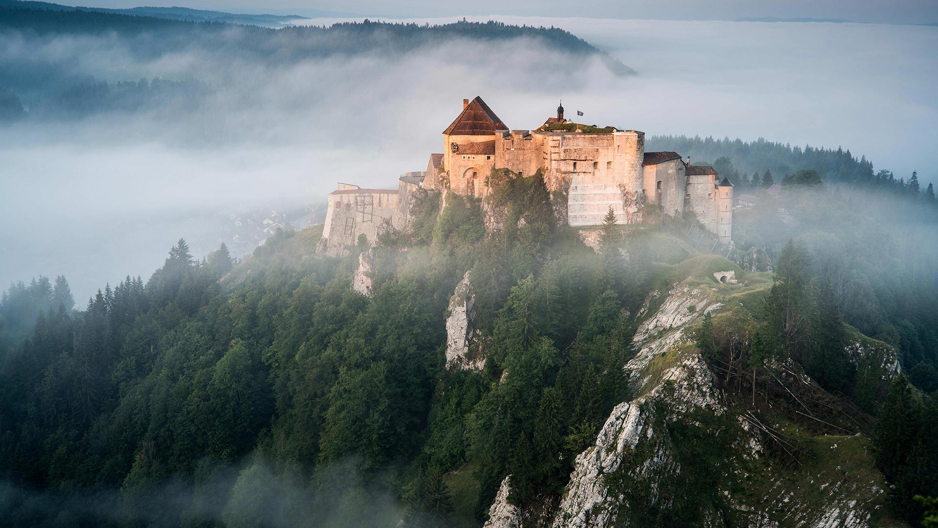
汝拉山中的Chateau de Joux堡,法国 Château de Joux in the Jura mountains of France (© Ivoha/Alamy)
Military art
Overlooking the valley linking France to Switzerland (the Cluse de Pontarlier), Joux castle – with its keep, towers, drawbridges, surrounding walls and fort – offers fantastic evidence of the way fortifications have developed over the years. Built in the 11th century, then modified by Vauban in the 17th century, people will discover 10 centuries of history there.
军事艺术
俯瞰连接法国和瑞士的山谷(Cluse de Pontarlier),Joux castle及其要塞、塔楼、吊桥、围墙和堡垒为多年来防御工事的发展提供了极好的证据。建于11世纪,17世纪被沃邦修缮,人们将在那里发现10个世纪的历史。
覆盖了Hallerbos森林地面的蓝铃花,比利时佛兰德 Bluebell flowers carpet the Hallerbos forest floor, Flanders, Belgium (© Jason Langley/plainpicture)

覆盖了Hallerbos森林地面的蓝铃花,比利时佛兰德 Bluebell flowers carpet the Hallerbos forest floor, Flanders, Belgium (© Jason Langley/plainpicture)
A glimpse of the 'Blue Forest'
What color do you normally associate with a forest? Well, in the Hallerbos forest of Belgium, that would be blue, for reasons you can clearly see here. For about 10 days every year, usually in late April or early May, this very old forest floor is transformed as bluebell hyacinths wake up from their winter slumber and carpet the forest floor in blue.
Even though it's a bit early for the fleeting blooms, today would be a good day to visit the 'Blue Forest,' for this is the day that the United Nations recognizes the International Day of Forests. The theme of this year's observance is reforestation, another thing that Hallerbos is known for. Large swaths of the ancient forest were destroyed by occupying forces during World War I, which prompted the Belgian government to roll out an extensive reforestation project starting in the 1930s. Within 20 years, Hallerbos was well on its way to being a healthy forest again, as the depleted native beech and oak trees were restocked.
“蓝色森林”一瞥
你通常认为森林是什么颜色的?好吧,在比利时的哈勒博斯森林,那将是蓝色的,因为你可以清楚地看到这里的原因。每年大约有10天,通常是在4月底或5月初,当风信子从冬眠中醒来,用蓝色地毯铺在森林地板上时,这片古老的森林地板就发生了变化。
尽管现在花开得有点早,但今天是参观“蓝林”的好日子,因为今天是联合国承认国际森林日的日子。今年纪念活动的主题是植树造林,这是哈勒博斯另一个著名的活动。在第一次世界大战期间,大片的古老森林被占领军摧毁,这促使比利时政府从20世纪30年代开始实施大规模的重新造林项目。20年内,随着耗尽的本地山毛榉和橡树重新进货,哈勒波斯又一次成为一片健康的森林。
帕尼迪斯沙丘上的日晷,立陶宛库尔斯沙嘴 Sundial on Parnidis Dune, Curonian Spit, in Lithuania (© amoklv/Getty Images)
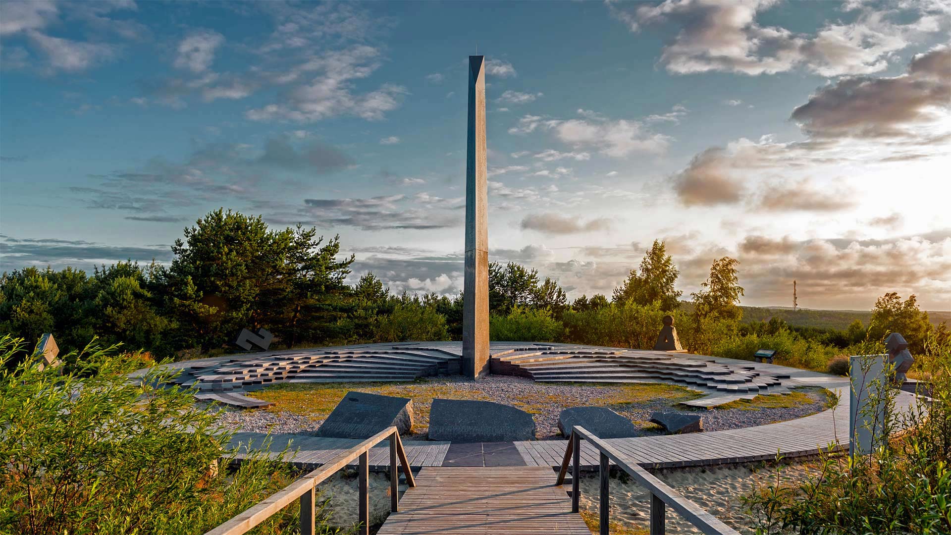
帕尼迪斯沙丘上的日晷,立陶宛库尔斯沙嘴 Sundial on Parnidis Dune, Curonian Spit, in Lithuania (© amoklv/Getty Images)
It's time for spring
This 40-foot sundial stands atop the Parnidis Dune, one of the scenic highlights of Curonian Spit, a UNESCO World Heritage Site shared by Lithuania and Russia. Built in 1995, the sundial was damaged by a hurricane a few years later and rebuilt in 2011. It accurately tells time by creating shadows on the steps, with notches for hours and half hours, as well as months, equinoxes, and solstices.
March 20 marks the spring (or vernal) equinox in the Northern Hemisphere, meaning that for the next six months daylight hours will outlast nighttime darkness. When it's winter in the Northern Hemisphere, those of us above the equator are tilted away from the sun, giving us shorter days and longer nights. In summer, we're tilted toward the sun, but the equinox is right in between. It's the moment during Earth's annual revolution around the sun when its axis is neither tilting away nor tilting toward the sun, giving everyone on the planet an equal split of day and night. This phenomenon happens twice a year—in March and again in September. In the Southern Hemisphere, everything's flipped. There, it's the autumnal equinox today—and, yes, winter is coming.
春天到了
这座40英尺高的日晷矗立在帕尼迪斯沙丘上,这座沙丘是立陶宛和俄罗斯共同拥有的联合国教科文组织世界遗产库伦吐谷(Curonian Spit)的一大亮点。日晷建于1995年,几年后被飓风破坏,2011年重建。它通过在台阶上创建阴影来准确地显示时间,刻痕为小时和半小时,以及月份、分点和至点。
3月20日是北半球的春分(或春分),这意味着在接下来的六个月里,白天的时间将比夜间的黑暗时间还要长。当北半球是冬天的时候,我们这些在赤道以上的人会远离太阳,使我们白天变短,夜晚变长。在夏天,我们向太阳倾斜,但春分正好在两者之间。这是地球每年绕太阳公转的一个时刻,它的轴既不向太阳倾斜,也不向太阳倾斜,使地球上的每个人都有一个平等的日夜之分。这种现象每年3月发生两次,9月又发生一次。在南半球,一切都在翻转。在那里,今天是秋分,是的,冬天来了。
航拍生长着树木的遇难船“阿德莱德市”残骸,澳大利亚磁岛 Aerial view of the 'City of Adelaide' shipwreck with trees growing on it, Magnetic Island, Queensland, Australia (© Amazing Aerial Agency/Offset by Shutterstock)

航拍生长着树木的遇难船“阿德莱德市”残骸,澳大利亚磁岛 Aerial view of the 'City of Adelaide' shipwreck with trees growing on it, Magnetic Island, Queensland, Australia (© Amazing Aerial Agency/Offset by Shutterstock)
Life carries on, rising from a ship's skeleton
We're on the northeastern coast of Australia in a small bay of Magnetic Island, looking down upon the sunken hull of the steamship, SS City of Adelaide. The vessel got its start in 1863 as a passenger steamship ferrying travelers and cargo between ports in Melbourne, Sydney, Honolulu, and San Francisco. Under sail, it was likened to a graceful bird in flight. In 1912, the City of Adelaide was gutted by fire, and in 1916, its burned hulk ran aground here in Cockle Bay while being transported after sale. Now it serves as an artificial island of sorts to a flock of cockatoos who live in the mangroves that have sprouted from the ship's rusted deck.
生命在继续,从船的骨架中升起
我们在澳大利亚东北海岸的一个小海湾的磁岛上,俯瞰沉没的船体,SS城市阿德莱德。这艘船开始于1863年,是一艘客轮,在墨尔本、悉尼、檀香山和旧金山的港口之间运送旅客和货物。在帆下,它被比作一只优雅的飞翔的鸟。1912年,阿德莱德市被大火夷为平地,1916年,被烧毁的绿巨人在出售后的运输途中在科克湾搁浅。现在,它就像一个人工岛,生活在红树林中的凤头鹦鹉成群,这些红树林是从船生锈的甲板上长出来的。
2013年正在喷发的埃特纳火山,意大利西西里岛 Mount Etna erupting in 2013, Sicily, Italy (© Wead/Alamy Live News)

2013年正在喷发的埃特纳火山,意大利西西里岛 Mount Etna erupting in 2013, Sicily, Italy (© Wead/Alamy Live News)
A sizzling summit hides in the clouds
Seen here with its explosive summit socked away in the clouds, Mount Etna towers over the Italian isle of Sicily as the tallest volcano in Europe—and maybe the crankiest, given its near-constant eruptions. The island peak has been highly active for perhaps half a million years and can still be counted on for a spectacular eruption every few years. This photograph shows Etna erupting in 2013.
云层中隐藏着一座炙热的山峰
埃特纳火山在意大利西西里岛上空耸立,是欧洲最高的火山,可能是最古怪的火山,因为它几乎一直在喷发。岛上的山峰已经高度活跃了大约50万年,仍然可以指望每隔几年就有一次壮观的喷发。这张照片显示埃特纳火山在2013年喷发。
阿伦群岛三座岛中最小的伊尼希尔岛,爱尔兰戈尔韦湾 Inisheer, the smallest of the three Aran Islands in Galway Bay, Ireland (© Chris Hill/Minden Pictures)

阿伦群岛三座岛中最小的伊尼希尔岛,爱尔兰戈尔韦湾 Inisheer, the smallest of the three Aran Islands in Galway Bay, Ireland (© Chris Hill/Minden Pictures)
An emerald isle of the Emerald Isle
If you were to find yourself wandering across the tiny island of Inisheer on March 17, you'd almost certainly hear someone greet you with a hearty 'Lá fhéile Pádraig sona dhuit!' That's because nearly all the island's 260 residents would want to wish you a happy Saint Patrick's Day in their native Irish tongue. The smallest of the three Aran Islands that are strung across the mouth of Galway Bay in western Ireland has been inhabited from prehistory, with artifacts of Bronze Age, Pagan, Celtic, Early Christian, Norman-Irish, Pastoral, Maritime Navigational, and more recent settlements scattered around its 1,400 acres. The tiny drystone wall subdivisions of the fields are a result of a long tradition of splitting family farms between all the children. After a few generations, farms were reduced to the garden-size patches you can see here.
These days, the islanders are best-known for keeping the traditional language, music, art, and stories alive, so you can be sure that they're celebrating the day in style. And if you can't make it there today (or next year), you could always come back on June 14, when residents celebrate the island's patron saint, Saint Caomhán. Bonus: It's likely to be a little warmer and drier then, too.
翡翠岛中的翡翠岛
如果你发现自己在3月17日漫步在伊尼舍尔的小岛上,你几乎肯定会听到有人用一个丰盛的"莱菲勒·佩德拉格·索纳·德胡特"来问候你!这是因为岛上260名居民几乎都想用他们的爱尔兰语祝你圣帕特里克节快乐。在爱尔兰西部戈尔韦湾口的三个阿兰群岛中,最小的一个从史前就有人居住,青铜时代、异教徒、凯尔特人、早期基督教、诺曼-爱尔兰、牧区、海洋导航以及最近的定居点散落在其1,400英亩的土地上。田地中微小的干石墙部分是将家庭农场拆分给所有儿童的悠久传统的结果。几代人之后,农场被缩小到花园大小的补丁,你可以看到这里。
如今,岛民最出名的是保持传统语言、音乐、艺术和故事的活力,因此您可以确信他们正在以时尚方式庆祝这一天。如果你今天(或明年)不能到那里,你总是可以在6月14日回来,届时居民们会庆祝岛上的守护神圣卡曼。奖金:那时可能更暖和一些,更干燥一些。
里昂天文钟,法国里昂 Lyon astronomical clock, Lyon, France (© kyolshin/Alamy)

里昂天文钟,法国里昂 Lyon astronomical clock, Lyon, France (© kyolshin/Alamy)
Perfect timing
If the first day of daylight saving time doesn't have you springing for joy, this towering timekeeper might be more your speed. The astronomical clock at Lyon Cathedral in France was built in 1660, long before daylight time became widely adopted in the 20th century. The clock's intersecting hands and dials don't just tell time, they form a flattened model of our planet that tracks the positions of the sun and moon relative to Earth. The zodiac dial, offset to account for the planet's rotational tilt, shows the star sign currently in season.
All this movement of circles and spheres might call to mind another observance of the day: March 14 is Pi Day, in celebration of the mathematical constant pi (aka π, or roughly 3.14). You remember pi from geometry class: It expresses the ratio of the distance around a circle to the distance across it. So it was essential to ancient astronomers who mapped these celestial workings, as well as to designers of intricate machines that simulate the circling heavens.
Wow, you kept reading through all the math talk? You deserve a sweet payoff. Why not slice into our Pi Day pie quiz?
完美的时机
如果夏令时的第一天没有让你欣喜若狂,那么这个高耸的计时员可能会比你更快。法国里昂大教堂的天文钟建于1660年,远远早于20世纪白天被广泛采用。时钟交叉的指针和刻度盘不仅告诉我们时间,它们还形成了一个地球的平面模型,跟踪太阳和月球相对于地球的位置。黄道十二宫的刻度盘,抵消了这颗行星的自转倾斜,显示了目前正处于这个季节的星座。
所有这些圆圈和球体的运动可能会让人想起另一个纪念日:3月14日是π日,庆祝数学常数π(又名π,约3.14)。您还记得几何类中的pi:它表示圆周围的距离与穿过圆的距离之比。因此,这对绘制这些天体运行图的古代天文学家,以及模拟环绕天空的复杂机器的设计者来说,都是至关重要的。
哇,你一直在读数学课?你应该得到一个甜蜜的回报。为什么不加入我们的派日测验呢?
森佩尔森林公园中的黑海杜鹃,德国吕根岛 Common rhododendrons in Semper Forest Park, Ruegen, Germany (© Sandra Bartocha/Minden Pictures)

森佩尔森林公园中的黑海杜鹃,德国吕根岛 Common rhododendrons in Semper Forest Park, Ruegen, Germany (© Sandra Bartocha/Minden Pictures)
All hail the 'king of shrubs'
Often called the 'king of shrubs,' rhododendrons are prized by gardeners for their green, glossy leaves and often brightly colored flowers. Depending on the variety, the blooms usually emerge anytime from late winter into summer. Either evergreen or deciduous, rhododendrons make up a large and diverse genus of woody plants in the heath family. With over 1,000 wild species and scores of cultivated options, rhododendrons are native to temperate areas of Asia, North America, and Europe, as well as some tropical parts of Southeast Asia and northern Australia. Our image today captures 'rhodies' in full bloom in March along a path at Semper Forest Park of Ruegen, Germany.
向“灌木之王”致敬
杜鹃花常被称为“灌木之王”,因其绿色、有光泽的叶子和色彩鲜艳的花朵而受到园丁的珍视。根据品种的不同,花期通常从冬末到夏季随时出现。无论是常绿或落叶,杜鹃花组成了一个大而多样的属木本植物在石南科。杜鹃花有1000多种野生物种和几十种栽培选择,原产于亚洲、北美和欧洲的温带地区,以及东南亚和澳大利亚北部的一些热带地区。我们今天的图片拍摄的是3月份在德国鲁根的森珀森林公园的一条小路上盛开的“罗地亚”。
一个气球在特奥蒂瓦坎日出时飞越太阳金字塔,墨西哥气球在特奥蒂瓦坎日出时飞越太阳金字塔 A balloon flies over the Pyramid of the Sun at sunrise in Teotihuacan, MexicoA balloon flies over the Pyramid of the Sun at sunrise in Teotihuacan, Mexico (©

一个气球在特奥蒂瓦坎日出时飞越太阳金字塔,墨西哥气球在特奥蒂瓦坎日出时飞越太阳金字塔 A balloon flies over the Pyramid of the Sun at sunrise in Teotihuacan, Mexico (© Marco Ugarte/AP Photo)
Ringing in the New Year at Teotihuacan
If the Aztecs had hot air balloons, they may well have greeted the new year like this—floating above the massive Sun Pyramid at sunrise today, the first day of the year according to the Aztec calendar. Also known as Yancuic Xihuitl, the Aztec New Year is still celebrated by some Indigenous Nahua communities here in central Mexico with songs, dances, and the flames of 'ocote' (pitch-pine) candles. Dancers wear colorful traditional costumes topped by quetzal feather headdresses, and celebrants greet the New Year by making loud noises with seashells, just as Aztecs did centuries ago. It's one of the many expressions of pre-Columbian tradition that managed to survive the Spanish conquest and modern erosion of Indigenous customs.
The Sun Pyramid is the largest structure in the ancient city that Aztecs called Teotihuacan (which means, roughly, 'birthplace of the gods'). The 8-square-mile site also contains other important pyramids, plazas, temples, palaces, and a complex network of underground tunnels. As grand a city as it once was, when the Aztecs arrived here in the 1400s, Teotihuacan had been abandoned for centuries. Its precise origins are a mystery, but it was first built by an unknown civilization sometime around 400 BCE. By 400 CE, Teotihuacan had become a center of industry and trade, the largest and most powerful city in the Americas and probably the sixth largest in the world. But by around 550 CE, its major monuments were sacked and deliberately burned, the magnificent pyramids and temples deserted—at least until the Aztecs arrived.
在特奥提华肯新年钟声响起
如果阿兹特克人有热气球的话,他们很可能在今天日出的时候,也就是阿兹特克日历上一年的第一天,像这样漂浮在巨大的太阳金字塔上迎接新年。阿兹特克新年也被称为Yancuic Xihuitl,墨西哥中部的一些土著Nahua社区仍然用歌声、舞蹈和“ocote”(沥青松)蜡烛的火焰来庆祝。舞者们穿着色彩鲜艳的传统服装,头上戴着羽绒头饰,庆祝者用贝壳发出响亮的声音迎接新年,就像几个世纪前阿兹特克人所做的那样。这是许多前哥伦布传统的表达方式之一,这些传统在西班牙征服和现代土著习俗的侵蚀下得以幸存。
太阳金字塔是古城中最大的建筑,阿兹特克人称之为特奥提瓦坎(大致意思是“神的诞生地”)。这个8平方英里的遗址还包括其他重要的金字塔、广场、寺庙、宫殿和复杂的地下隧道网络。当阿兹特克人在14世纪来到这里时,特奥提瓦坎曾经是一座宏伟的城市,但它已经被遗弃了几个世纪。它的确切起源是个谜,但它最初是由公元前400年左右的一个未知文明建造的。到公元400年,特奥蒂瓦坎已经成为一个工业和贸易中心,美洲最大和最强大的城市,可能是世界第六大城市。但到公元前550年左右,它的主要纪念碑被洗劫一空,并被蓄意烧毁,宏伟的金字塔和寺庙被遗弃,至少直到阿兹特克人到来。