Invergarry村庄附近的森林,苏格兰 Forest near the village of Invergarry, Scotland (© Matt Anderson Photography/Getty Images)
Invergarry村庄附近的森林,苏格兰 Forest near the village of Invergarry, Scotland (© Matt Anderson Photography/Getty Images)
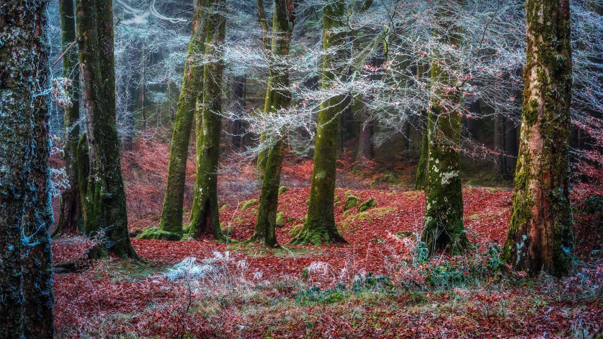
The Great Glen
Was this photo taken in a peppermint forest? This rare and delicate hoarfrost may look like a confectioner's coating, but it's just the ice that forms when the Scottish Highlands' fog mixes perfectly with a sharp cold snap.
We're in a storied section of Scotland—sort of a lowland of the Highlands—called the Great Glen. This deep valley runs 62 miles coast to coast—from a North Sea inlet on the east to Loch Linnhe on the west. The Great Glen's gentle slopes enclose fairytale forests like these as well as quaint villages and lochs—including nearby Invergarry and Loch Oich, respectively.
大峡谷
这张照片是在薄荷林里拍的吗?这种罕见而微妙的白霜看起来像糖果店的外衣,但它只是当苏格兰高地的雾与刺骨的寒流完美混合时形成的冰。
我们在苏格兰的一个历史悠久的地区,有点像高地的低地,叫做大峡谷。这个深谷从东到西从北海的一个海湾到林河湖,沿海岸延伸62英里。大峡谷的缓坡环绕着童话般的森林,还有古雅的村庄和湖泊,包括附近的因弗加里湖和奥奇湖。
莫利森艺术家塞佩的《新呼吸》, 瑞士格鲁埃河畔 'A New Breath' by artist Saype in Moléson-sur-Gruyères, Switzerland (© Valentin Flauraud/Shutterstock)
莫利森艺术家塞佩的《新呼吸》, 瑞士格鲁埃河畔 'A New Breath' by artist Saype in Moléson-sur-Gruyères, Switzerland (© Valentin Flauraud/Shutterstock)
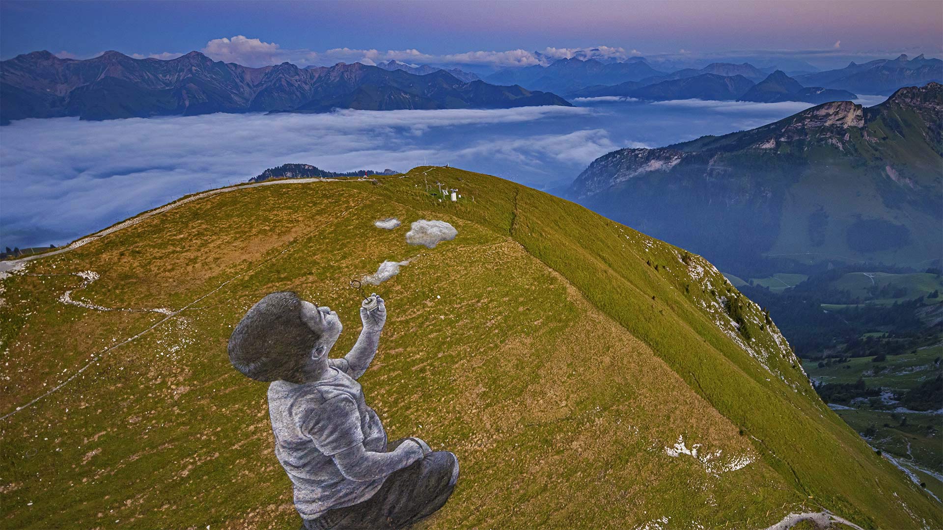
World Children's Day
For World Children's Day, we're featuring an aerial view of a larger-than-life painting next to the summit of the Moléson in the Swiss Prealps. The 16,000-square-foot fresco is titled 'Un Nouveau Souffle' (A New Breath) and depicts a child blowing clouds toward the horizon. It was created by French-Swiss artist Saype—real name Guillaume Legros—who is known for his grassy graffiti around the world. The eco-friendly artist uses biodegradable paints made from natural pigments such as coal and chalk, so by the time you read this, his land art will have already disappeared into the soil.
Saype's mountaintop mural aims to inspire childlike wonder, which is an apt message for World Children's Day. Though there are numerous Children's Day celebrations around the globe, and on varying dates, the United Nations created World Children's Day—observed every November 20—to celebrate kids worldwide and to promote their welfare.
Perhaps you can recall picking out shapes and pictures in the clouds as they drifted by when you were young. Why not turn that fuzzy feeling into action and find out how you can help build a better future for children. Just like watching clouds, all you need is a little imagination.
世界儿童节
为了庆祝世界儿童节,我们将在瑞士公园的莫利森峰旁鸟瞰一幅超凡脱俗的油画。这幅16000平方英尺的壁画名为“新口味的蛋奶酥”(一种新气息),描绘了一个孩子将云朵吹向地平线。它是由法国瑞士艺术家赛义普(Saype)创作的,真名纪尧姆·勒格罗斯(Guillaume Legros),他以其草草涂鸦闻名于世。这位环保艺术家使用由煤和白垩等天然颜料制成的可生物降解的颜料,所以当你读到这篇文章时,他的土地艺术已经消失在土壤中。
Saype的山顶壁画旨在激发孩子般的好奇心,这是世界儿童节的一个恰当信息。尽管全球各地都有许多儿童节庆祝活动,而且日期各不相同,但联合国还是在每年11月20日设立了世界儿童节,以庆祝全世界的儿童并促进他们的福利。
也许你还记得,当你年轻的时候,在云层中飘过的形状和图片中挑选出来的。为什么不把这种模糊的感觉转化为行动,看看你能如何帮助孩子们建立一个更美好的未来。就像看云一样,你只需要一点想象力。
阿西尼博因山公园的秋叶,加拿大不列颠哥伦比亚省 (© Mitch Pittman/TANDEM Stills + Motion)
酷似隧道的峡谷,犹他州锡安国家公园 The Subway slot canyon in Zion National Park, Utah (© Stan Moniz/Tandem Stills + Motion)
锡安国家公园的地铁槽峡谷, 犹他州 The Subway slot canyon in Zion National Park, Utah (© Stan Moniz/Tandem Stills + Motion)
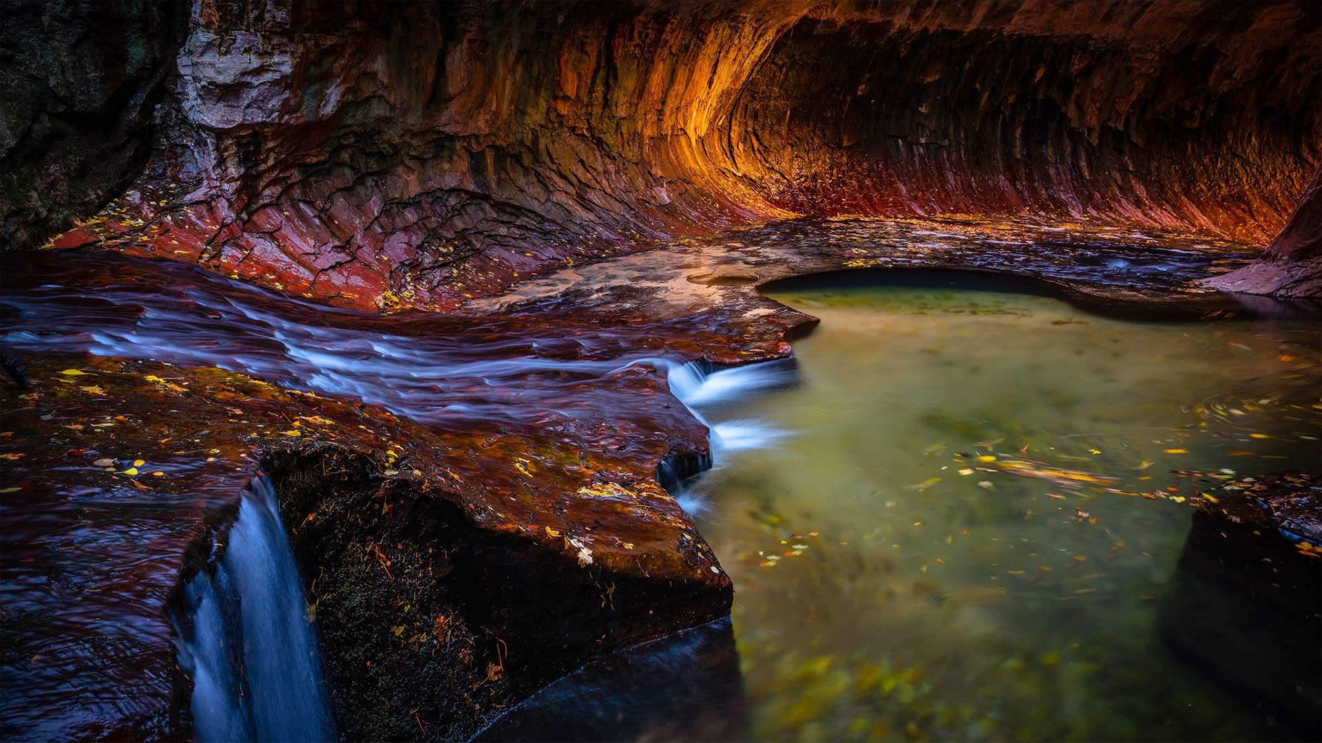
Zion National Park, Utah
Today, we're celebrating the 102nd anniversary of Southwest Utah's Zion National Park with a visit to its Subway slot canyon. Zion is defined by its breathtakingly steep red cliffs, its maze of sandstone canyons, and its waterfalls with colorful hanging gardens. Visitors here can trek for miles, ducking into crevices and resting in canyons once occupied by the Ancestral Puebloans.
The bravest souls might venture into Zion's Subway. Yes, there's a 'subway' here, but it's not a transit system nor a sandwich shop. You see the image we are featuring today? That's the Subway. It's a geologic marvel, a hollowed-out canyon reminiscent of a subway tunnel. To get here requires some technical experience, or at least a guide. There will be bouldering, climbing down waterfalls, possibly rappelling, and a 9-mile roundtrip hike on a trail which is a running stream with parts so deep, hikers have to wade or swim, depending on water levels. Did we mention the water is cold? But all that work will be worth it in the end for a photo like this. Zion is the third most-visited national park in the country, but the park grants just 60 permits a day to hikers who want to attempt a visit to the Subway.
犹他州锡安国家公园
今天,我们将参观犹他州西南部的锡安国家公园的地铁狭缝峡谷,以庆祝其102周年。锡安以其惊人的陡峭红色悬崖、迷宫般的砂岩峡谷和瀑布以及五颜六色的空中花园而著称。这里的游客可以跋涉数英里,潜入裂缝,在曾经被祖先普韦布洛人占据的峡谷中休息。
最勇敢的人可能会冒险进入锡安的地铁。是的,这里有“地铁”,但它既不是公交系统,也不是三明治店。你看到我们今天展示的图像了吗?那是地铁。这是一个地质奇迹,一个空洞的峡谷让人想起地铁隧道。到这里需要一些技术经验,或者至少需要一个向导。这里将有抱石、爬下瀑布、可能是攀岩,还有9英里的往返徒步旅行。这条小道是一条流动的溪流,局部很深,徒步旅行者必须涉水或游泳,具体取决于水位。我们有没有提到水是凉的?但对于这样一张照片来说,所有这些工作最终都是值得的。锡安是该国第三大游客最多的国家公园,但该公园每天只向想要尝试参观地铁的徒步旅行者发放60张许可证。
蒂萨附近的波希米亚瑞士国家公园, 捷克共和国 Bohemian Switzerland National Park near Tisá, Czech Republic (© Amazing Aerial Agency/Offset)
蒂萨附近的波希米亚瑞士国家公园, 捷克共和国 Bohemian Switzerland National Park near Tisá, Czech Republic (© Amazing Aerial Agency/Offset)
Bohemian Switzerland National Park
Today we rhapsodize about the beautiful Bohemian Switzerland National Park, but we're hundreds of miles from Switzerland. The park's name originated with Swiss painters visiting the Kingdom of Bohemia, now the western half of the Czech Republic. They were reminded of their homeland by this region's dramatic sandstone formations. Turns out the acclaimed artist named Mother Nature finds inspiration here, too, turning the park's pockets of thick forest into a canvas of warm oranges and yellows every autumn.
波希米亚瑞士国家公园
今天我们为美丽的波希米亚瑞士国家公园狂想曲,但我们离瑞士有几百英里远。这个公园的名字起源于瑞士画家访问波希米亚王国,现在是捷克共和国的西半部。这个地区引人注目的砂岩地层让他们想起了自己的祖国。事实证明,这位名为“大自然母亲”的著名艺术家也在这里找到了灵感,每年秋天,他都会把公园里密密麻麻的森林变成一幅温暖的橘子和黄色的画布。
螺旋沼泽鸟兽禁猎区的小径, 佛罗里达州 Boardwalk Trail at Corkscrew Swamp Sanctuary in Florida (© Bill Gozansky/Alamy)
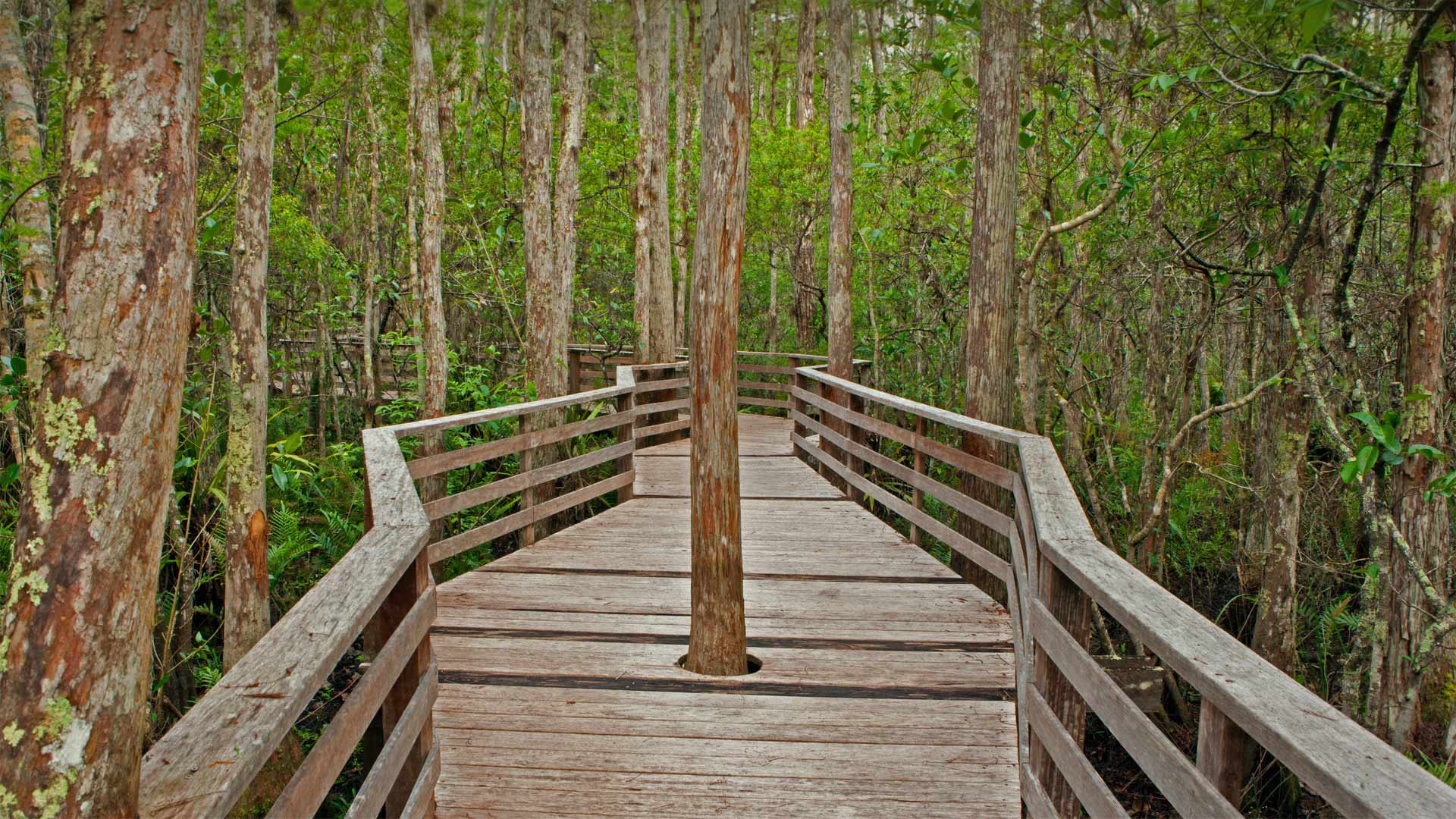
螺旋沼泽鸟兽禁猎区的小径, 佛罗里达州 Boardwalk Trail at Corkscrew Swamp Sanctuary in Florida (© Bill Gozansky/Alamy)
Florida Corkscrew Swamp Sanctuary
And we mean that in the nicest possible way. After all, what's nicer on a crisp November day than lacing up those hiking boots and hitting the trail? (Especially when that day happens to be Take a Hike Day!) Of course, there might be no trails to hit were it not for state and national park rangers, foresters, nonprofit employees, volunteers, and others who forge them through the wilderness. Or in some cases build them, as with this boardwalk in the Corkscrew Swamp Sanctuary near Florida's Gulf Coast.
Construction of Corkscrew's Boardwalk Trail started in the mid-1950s by National Audubon, which manages Corkscrew Swamp as a wildlife sanctuary. It's clearly built for the terrain—particularly this cypress poking through a bespoke hole in the path. The walkway allows trekkers to easily traverse the wetlands without trampling the diverse flora and fauna on the damp ground.
佛罗里达软木塞沼泽保护区
我们的意思是以最好的方式。毕竟,在11月的一个晴朗的日子里,有什么比系上登山靴去小径更好的呢?(特别是当那天正好是徒步旅行日!)当然,如果不是州和国家公园的护林员、林业工作者、非营利组织员工、志愿者和其他在荒野中锻造他们的人,可能就不会有小路可走了。或者在某些情况下建造它们,比如佛罗里达海湾海岸附近的科克斯洛沼泽保护区的木板路。
20世纪50年代中期,国家奥杜邦(National Audubon)开始修建科克斯勒(Corkscrew)的木板路小径,该公司将科克斯勒沼泽作为野生动物保护区进行管理。它显然是专为地形而建的,尤其是这棵柏树穿过小路上一个定制的洞。这条人行道让徒步旅行者可以轻松地穿越湿地,而不会践踏潮湿地面上的各种动植物。
穿越格伦菲南高架桥的蒸汽火车,苏格兰因弗内斯郡 The Jacobite steam train crossing the Glenfinnan Viaduct in Inverness-shire, Scotland (© The Escape of Malee/Shutterstock)
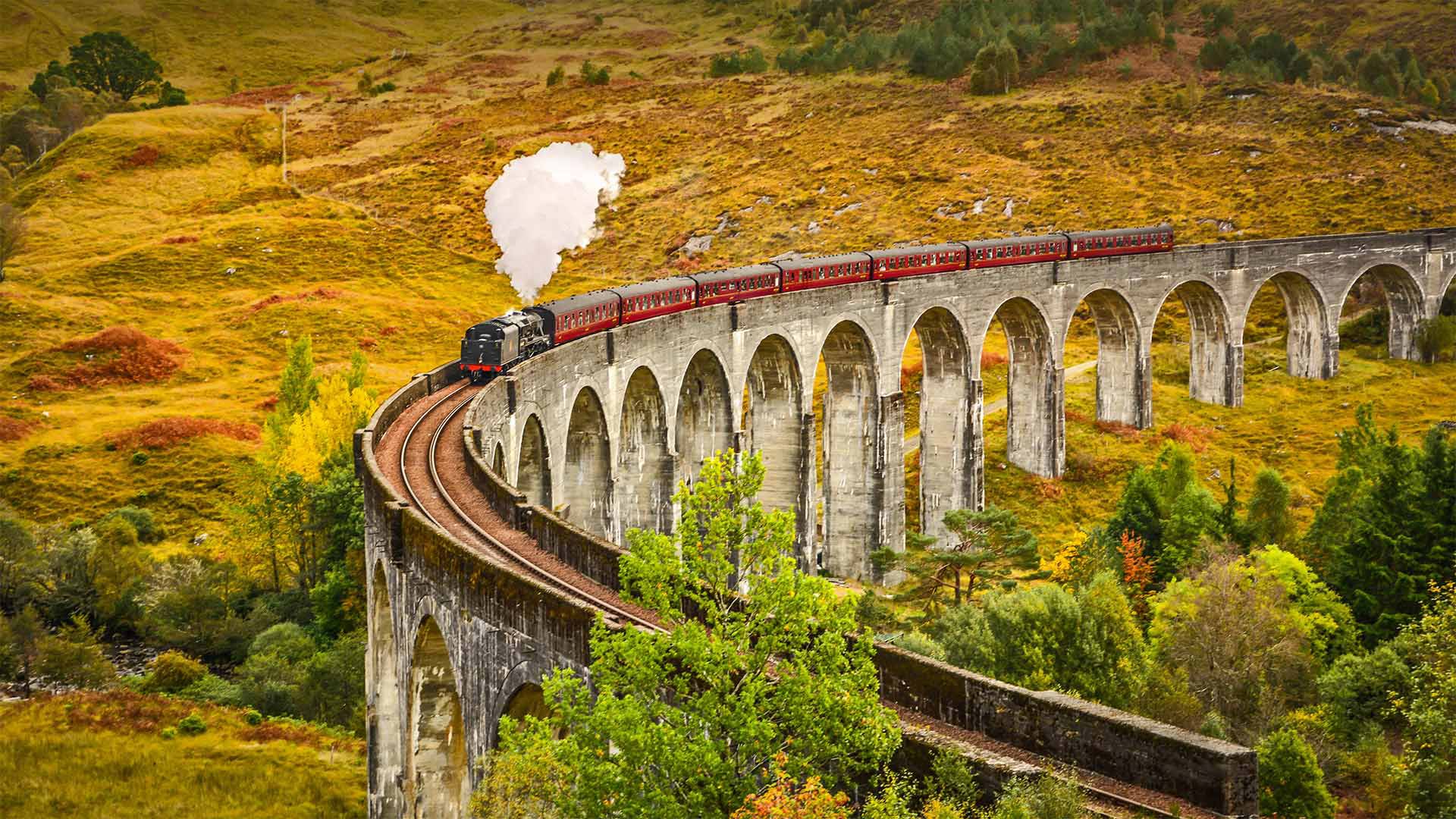
穿越格伦菲南高架桥的蒸汽火车,苏格兰因弗内斯郡 The Jacobite steam train crossing the Glenfinnan Viaduct in Inverness-shire, Scotland (© The Escape of Malee/Shutterstock)
Scotland Glenfinnan Viaduct
Muggles from around the world flock to this iconic scene at the top of Loch Shiel in the West Highlands of Scotland to marvel at the 21-arched Glenfinnan Viaduct, also known as the 'Harry Potter bridge.' The curving structure was made famous in the film adaptation of J.K. Rowling's novels as part of the route taken by the Hogwarts Express, which carries students to and from the wizarding boarding school at the start and end of every term. And today is a reason to celebrate for Potterheads, as we are marking the 20th anniversary of Harry Potter's big screen debut.
In real life, the Hogwarts Express is the Jacobite steam train. It's described as one of the greatest railway journeys in the world, taking passengers across the viaduct on a magical 84-mile round-trip between the towns of Fort William and Mallaig in summer months, passing Ben Nevis, the highest mountain in the United Kingdom, and some of Scotland's most splendid scenery.
苏格兰格兰芬南高架桥
来自世界各地的麻瓜们蜂拥而至,来到苏格兰西部高地希勒湖山顶的这一标志性场景,惊叹于21座拱形格伦芬南高架桥,也被称为“哈利波特桥”。这座弯曲的结构在改编自J.K.罗琳小说的电影中出名,是霍格沃茨特快列车路线的一部分,在每个学期的开始和结束时,它会运送学生往返于魔法寄宿学校。今天是我们为《波特头》庆祝的一个理由,因为我们正在庆祝《哈利波特》大银幕首映20周年。
在现实生活中,霍格沃茨特快列车是雅各比特蒸汽火车。它被描述为世界上最伟大的铁路旅行之一,在夏季的几个月里,乘客们将穿越高架桥,在威廉堡和马莱格镇之间神奇地往返84英里,途经英国最高的山脉本尼维斯,以及苏格兰最壮丽的风景。
第一悬崖步道,瑞士格林德瓦 First Cliff Walk on First near Grindelwald, Switzerland (© Hans-Georg Eiben/eStock Photo)
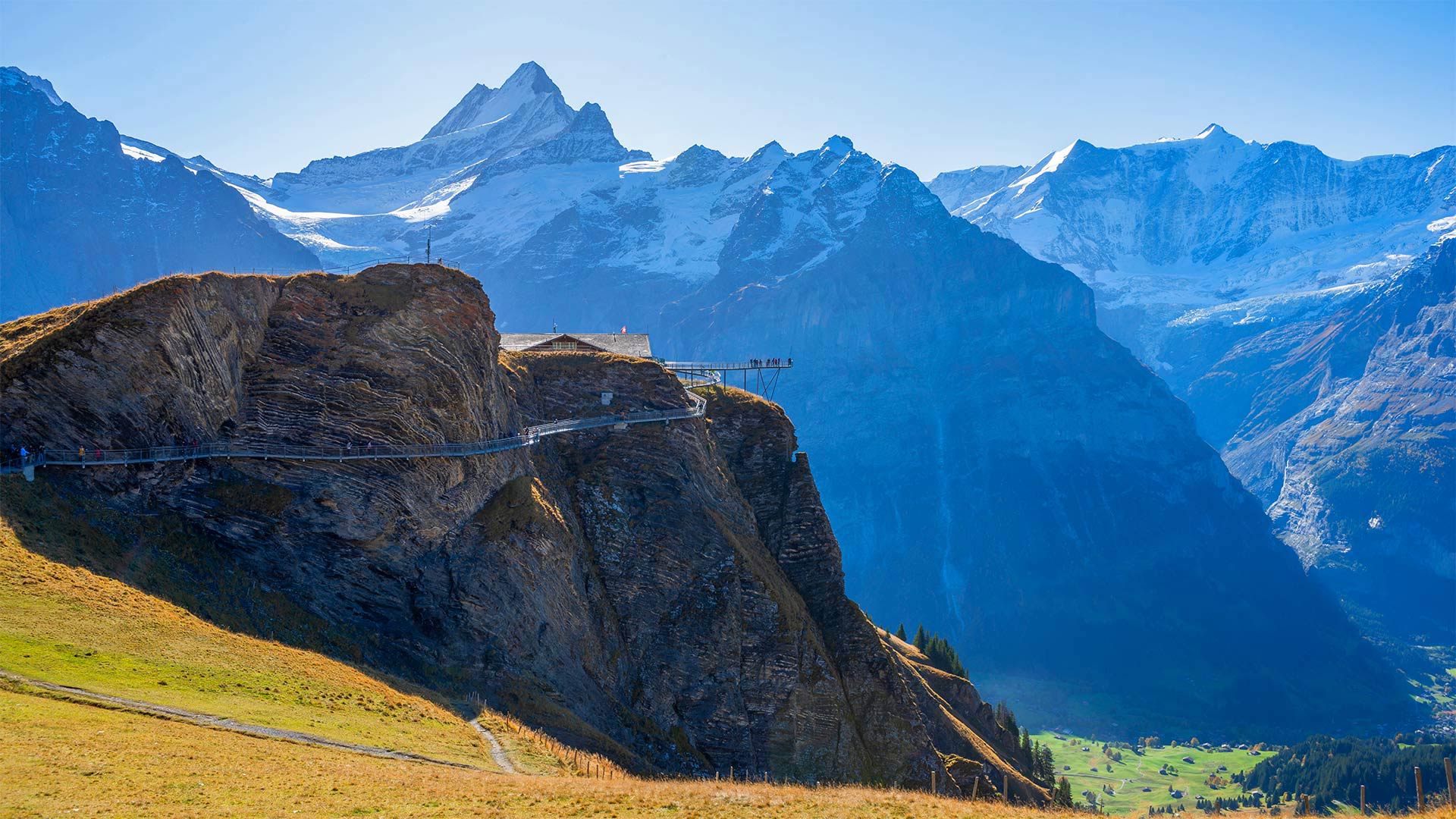
第一悬崖步道,瑞士格林德瓦 First Cliff Walk on First near Grindelwald, Switzerland (© Hans-Georg Eiben/eStock Photo)
Switzerland First Cliff Walk
When it comes to breathtaking mountain scenery, it's difficult to top the village of Grindelwald in the center of the Swiss Alps, flanked as it is on all sides by towering peaks such as Mannlichen, Faulhorn, and the Wetterhorn. In winter, Grindelwald is home to one of the biggest ski resorts in Switzerland's Jungfrau region, and even in the offseason there's still plenty of adrenaline-inducing activity to be found here.
For example, you can take a gondola from the village up to a a small peak called First, home of the First Cliff Walk observation platform, seen in our photo. Visitors walk up the metal footbridge that winds along the side of First and onto the platform, which extends out nearly 150 feet over the abyss. The sheer beauty and verticality of the views from this spot are sure to set just about anyone's heart racing.
瑞士第一悬崖步道
说到令人叹为观止的山景,很难登上瑞士阿尔卑斯山中心的格林德瓦尔德村的顶峰,因为它的两侧都是高耸的山峰,如曼利希峰、福尔霍恩峰和维特霍恩峰。在冬天,格林德瓦尔德是瑞士少女峰地区最大的滑雪胜地之一的所在地,即使在休赛期,这里仍然有大量的肾上腺素诱导活动。
例如,你可以从村子里搭一辆平底船到一个叫First的小山顶,这是我们照片中第一个悬崖步行观察平台的所在地。游客们沿着蜿蜒在第一大道一侧的金属人行桥走上平台,平台延伸到深渊上方近150英尺。从这个地方看去,景色的绝对美丽和垂直肯定会让任何人心跳加速。
鸟瞰埃尔塔霍峡谷, 西班牙龙达小镇 Aerial view of El Tajo gorge and the Puente Nuevo bridge in Ronda, Málaga, Spain (© Jude Newkirk/Amazing Aerial Agency)
鸟瞰埃尔塔霍峡谷, 西班牙龙达小镇 Aerial view of El Tajo gorge and the Puente Nuevo bridge in Ronda, Málaga, Spain (© Jude Newkirk/Amazing Aerial Agency)
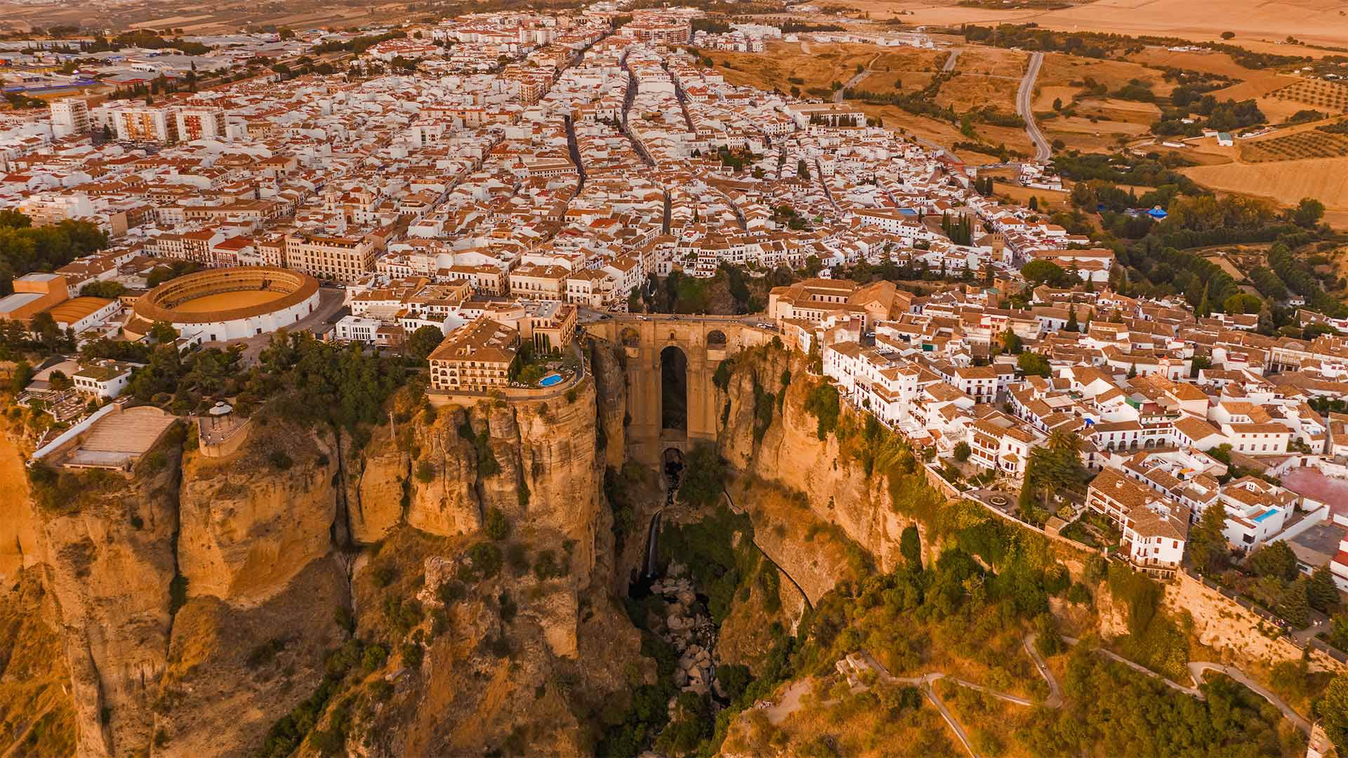
Spain El Tajo Gorge
Today we're visiting the mountaintop town of Ronda in the Málaga province of Andalusia, in the south of Spain. First settled by the Celts and later inhabited by the Romans and Moors, this dramatic cliffside setting is split in two by the El Tajo gorge, a rocky drop plummeting nearly 400 feet to the Guadalevín River. There are three bridges that span the gorge, the largest and newest of which features in the center of our homepage image and is—appropriately enough—called Puente Nuevo (New Bridge). Despite its name, the bridge is more than couple of centuries old—it was completed in 1793 and connects the Moorish old town, La Ciudad, with the new town, El Mercadillo.
The Puente Nuevo was completed by Spanish architect Jose Martín de Aldehuela, who also designed another of the historic town's famous landmarks—the open-air circular building you can see to the left of the bridge. The Plaza de Toros de Ronda is one of Spain's oldest bullrings. Built entirely of stone in the 1780s, it's considered the birthplace of modern bullfighting. It was frequented by two giants of American culture—Ernest Hemingway and Orson Welles, who were inspired by Ronda's beauty and bullfighting traditions. They spent many summers in these parts, and Welles' ashes were scattered in the town at the country estate of his great bullfighting friend, Antonio Ordóñez.
西班牙塔霍峡谷
今天,我们将参观西班牙南部安达卢西亚马拉加省的山顶小镇隆达。最初由凯尔特人定居,后来由罗马人和摩尔人居住,这一引人注目的悬崖边环境被El-Tajo峡谷一分为二,这是一个岩石瀑布,垂直下落近400英尺,直达瓜达莱文河。有三座桥横跨峡谷,其中最大、最新的一座桥位于我们主页图像的中心,被恰当地称为Puente Nuevo(新桥)。尽管它的名字,这座桥已经有两个多世纪的历史了。它是在1793年建成的,连接着摩尔人的老城La Ciudad和新城El Mercadillo。
Puente Nuevo由西班牙建筑师Jose Martín de Aldehuela完成,他还设计了这座历史小镇的另一个著名地标——你可以在桥的左侧看到的露天圆形建筑。隆达广场是西班牙最古老的斗牛场之一。在1780年代完全用石头建成,它被认为是现代斗牛的发源地。两位美国文化巨人欧内斯特·海明威(Ernest Hemingway)和奥森·威尔斯(Orson Welles)经常光顾这里,他们的灵感来自隆达的美丽和斗牛传统。他们在这些地方度过了许多夏天,威尔斯的骨灰散落在镇上他伟大的斗牛朋友安东尼奥·奥德涅斯的乡村庄园里。
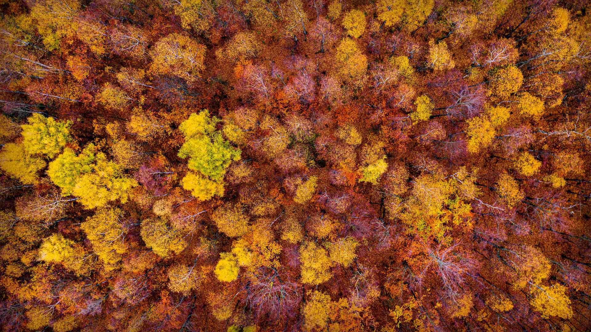
海狸湾度假公园, 美国俄克拉何马州 Beavers Bend Resort Park near Broken Bow, Oklahoma (© Inge Johnsson/Alamy)
海狸湾度假公园, 美国俄克拉何马州 Beavers Bend Resort Park near Broken Bow, Oklahoma (© Inge Johnsson/Alamy)
Beavers Bend Resort Park
To take in these incredible fall colors, we've come to Beavers Bend State Park, a 1,300-acre wilderness in the southeast corner of Oklahoma. It's a scene that may confound your expectations for the wilds of the 'OK' state. The 'bend' referenced in the park's name is a nearly 180-degree turn in Mountain Fork, the river that runs through the park.
Mountain Fork was dammed to form Broken Bow Lake, which is not just another draw for park visitors interested in water-related recreation but is also used as a reservoir and hydroelectric power generator. To really take in the autumn color in Beavers Bend—or to enjoy it during just about any time of year—there are numerous hiking trails in the park and a train that chugs through some of the park's scenic areas as well.
海狸湾度假村公园
为了欣赏这些令人难以置信的秋天色彩,我们来到了海狸湾州立公园,这是俄克拉荷马州东南角一片1300英亩的荒野。这是一个场景,可能会混淆你对“OK”状态的期望。公园名称中提到的“弯道”是流经公园的河流Mountain Fork的近180度转弯。
Mountain Fork筑坝形成了断头湖,这不仅吸引了对水相关娱乐感兴趣的公园游客,还被用作水库和水力发电机。为了真正欣赏海狸湾的秋色,或者在一年中的任何时候都能欣赏到它,公园里有无数的徒步小径,还有一列火车在公园的一些风景区穿行。