标签 犹他 下的文章
犹他州锡安国家公园的维尔京河,美国 Virgin River in Zion National Park, Utah (© Jonathan Ross/Getty)
犹他州锡安国家公园的维尔京河,美国 Virgin River in Zion National Park, Utah (© Jonathan Ross/Getty)
锡安国家公园的维珍河
我们的照片将我们带到16英里长的维珍河,在那里它穿过犹他州锡安峡谷上游,形成了一个壮观的千英尺深的峡谷。流经锡安国家公园(今天已满103岁!),由于科罗拉多高原、大盆地和莫哈韦沙漠交汇处的独特生物群落,维珍河是其他地方所没有的独特植物和动物的家园。如果没有维珍河水系的水,像世界上最稀有的物种之一的wondfin小鱼这样的生物就不可能存在。
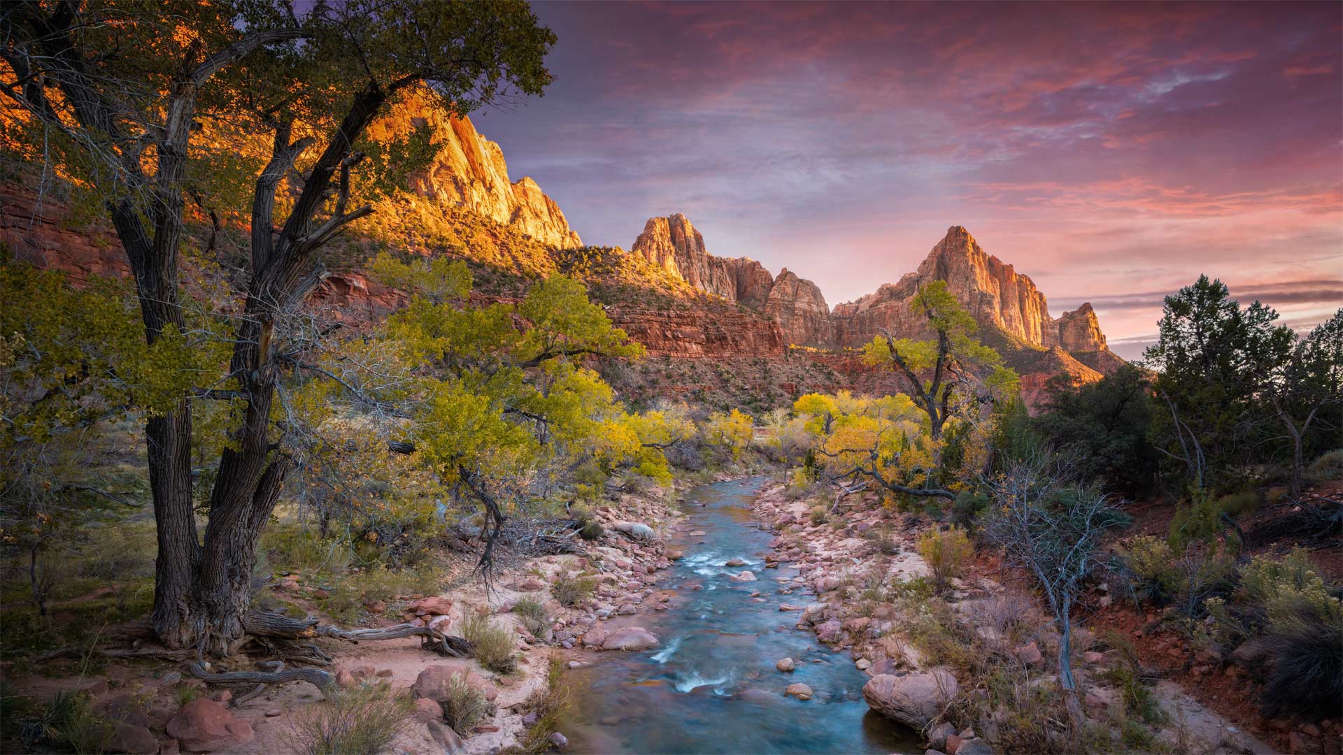
Virgin River in Zion National Park
Our photo brings us to a 16-mile stretch of the Virgin River where it cuts a spectacular thousand-foot-deep gorge through the upper reaches of Utah's Zion Canyon. Flowing through Zion National Park (which turns 103 today!), the Virgin River is home to unique plants and animals that aren't found anywhere else, due to the unique intersection of biomes found where the Colorado Plateau, Great Basin, and Mojave Desert all meet. Without the water of the Virgin River system, creatures like the woundfin minnow, one of rarest species on the planet, couldn't exist.
圆顶礁国家公园里的希克曼桥,美国犹他州 The Hickman Bridge at Capitol Reef National Park, Utah (© Tim Fitzharris/Minden Pictures)
圆顶礁国家公园里的希克曼桥,美国犹他州 The Hickman Bridge at Capitol Reef National Park, Utah (© Tim Fitzharris/Minden Pictures)
走上这条人迹常见的小径 Take the trail more traveled by
Happy Birthday Capitol Reef National Park
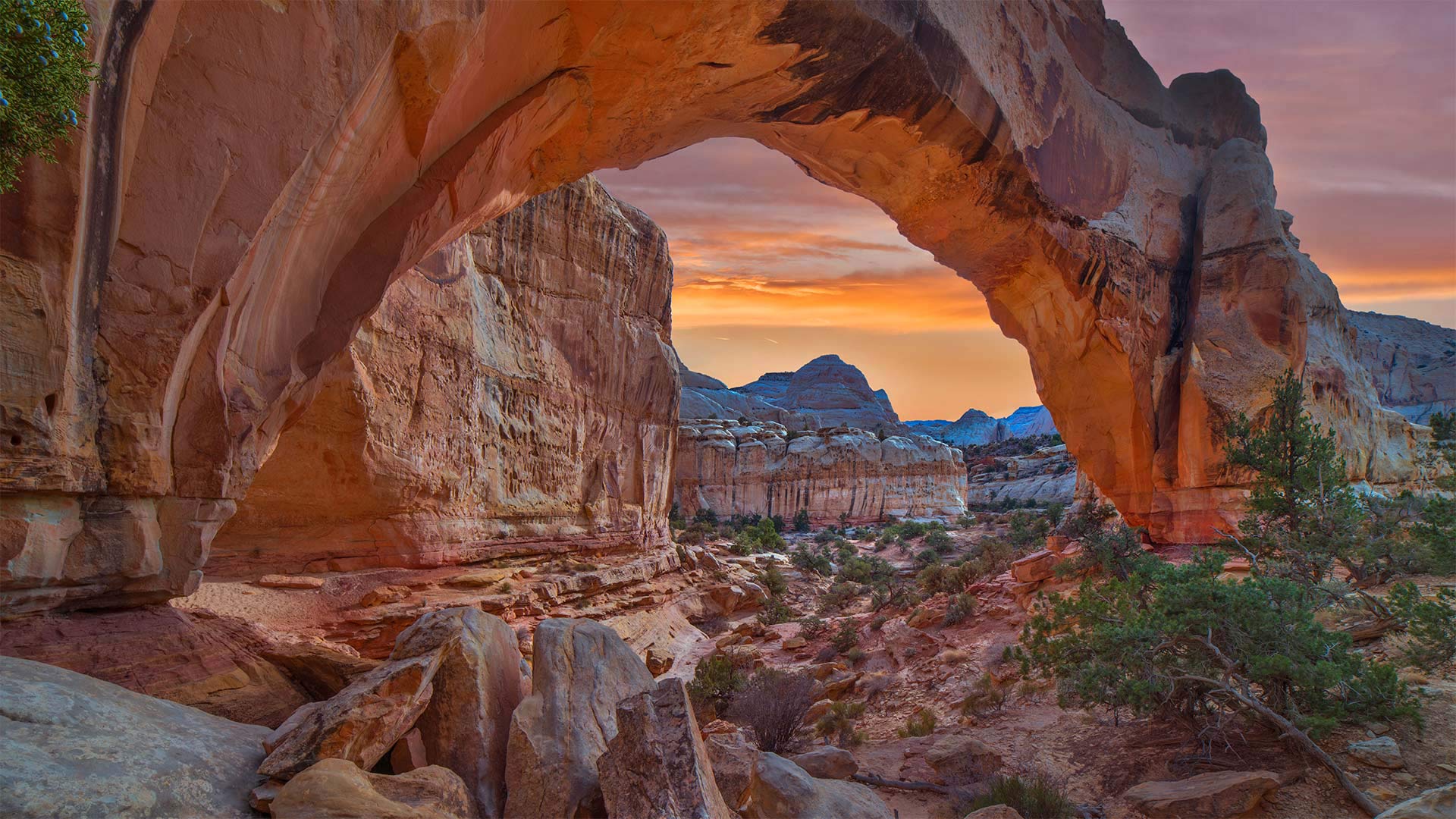
You won't find a lot of solitude on the Hickman Bridge Trail, a 1.7-mile route in Capitol Reef National Park that leads to this magnificent natural arch. The trail is used by hikers, runners, and nature lovers drawn by incredible rock formations, gullies, and remnants from the Fremont Culture Native American civilization from the early part of the 20th century. Hickman Bridge itself is one of the best-known geologic features of the park.
Capitol Reef National Park was first established as a national monument on this day in 1937, then became a national park in 1971. Capitol Reef is named for its massive rock domes that reminded nearby residents of that famous rotunda of the US Capitol Building back in Washington, DC. Why Capitol 'Reef,' though? Because the imposing formations were major obstacles to travelers through the region, the same way a coral reef is an obstacle to sailors.
The geology of the park is defined by the nearly 100-mile Waterpocket Fold, a wrinkle in the Earth's crust that formed around the end of the dinosaur era. Wind, rain, and time have eroded the Navajo Sandstone into colorful canyons, buttes, and natural arches like Hickman Bridge. The dramatic rock formations make Capitol Reef a favorite destination in the American West.
生日快乐国会山珊瑚礁国家公园
在希克曼大桥小径上你不会发现太多的孤独,这条小径位于国会山礁国家公园,全长1.7英里,通往这座宏伟的天然拱门。这条小径供远足者、跑步者和自然爱好者使用,它们由难以置信的岩层、沟壑和20世纪早期弗里蒙特文化-美洲原住民文明的遗迹绘制而成。希克曼大桥本身就是公园最著名的地质特征之一。
国会山礁国家公园于1937年的今天首次作为国家纪念碑建立,然后在1971年成为国家公园。国会山礁以其巨大的岩石圆顶而命名,这让附近的居民想起了位于华盛顿特区的美国国会大厦的著名圆形大厅。然而,为什么国会大厦是“暗礁”?因为壮观的地形是该地区旅行者的主要障碍,就像珊瑚礁是水手的障碍一样。
公园的地质特征是近100英里的水袋褶皱,这是在恐龙时代末期形成的地壳褶皱。风、雨和时间把纳瓦霍砂岩侵蚀成了五颜六色的峡谷、山丘和希克曼大桥那样的天然拱门。引人注目的岩层使国会山礁成为美国西部最受欢迎的目的地。
酷似隧道的峡谷,犹他州锡安国家公园 The Subway slot canyon in Zion National Park, Utah (© Stan Moniz/Tandem Stills + Motion)
锡安国家公园的地铁槽峡谷, 犹他州 The Subway slot canyon in Zion National Park, Utah (© Stan Moniz/Tandem Stills + Motion)
Zion National Park, Utah
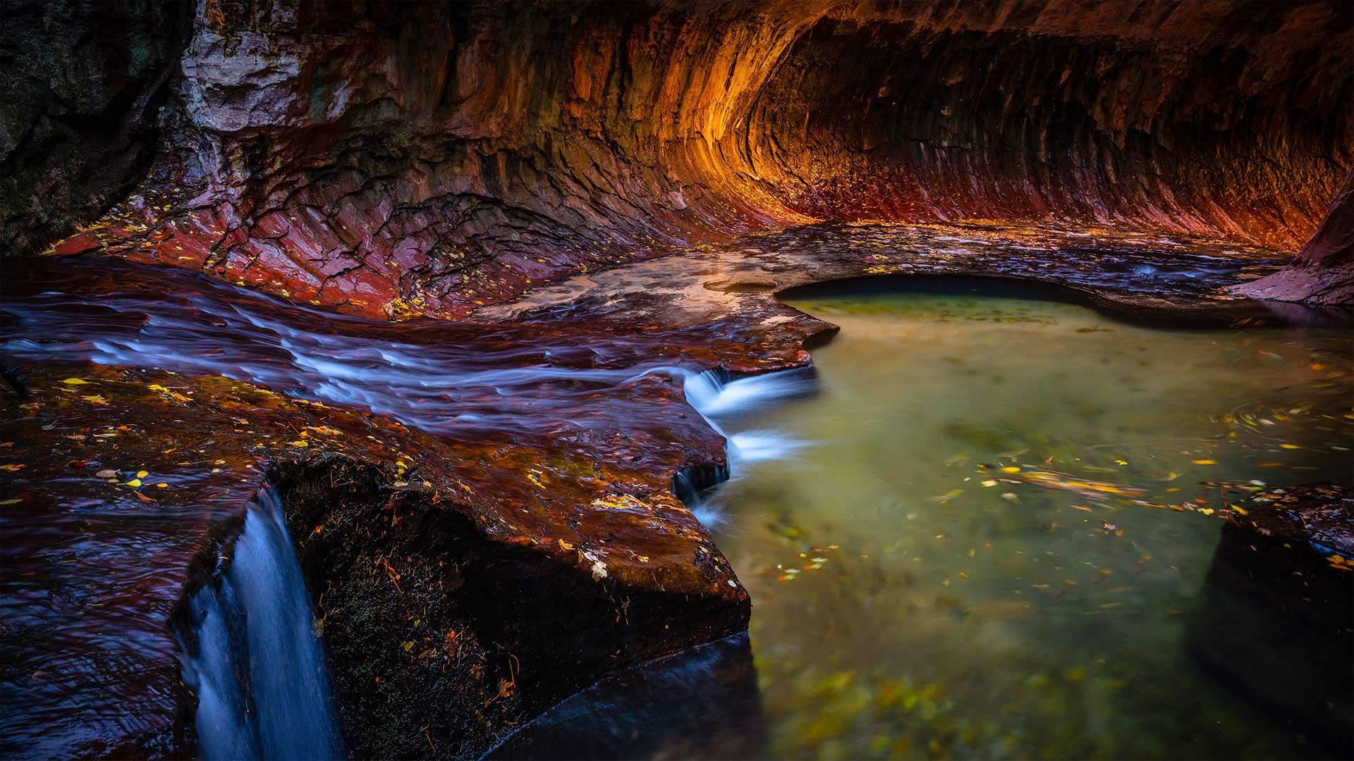
Today, we're celebrating the 102nd anniversary of Southwest Utah's Zion National Park with a visit to its Subway slot canyon. Zion is defined by its breathtakingly steep red cliffs, its maze of sandstone canyons, and its waterfalls with colorful hanging gardens. Visitors here can trek for miles, ducking into crevices and resting in canyons once occupied by the Ancestral Puebloans.
The bravest souls might venture into Zion's Subway. Yes, there's a 'subway' here, but it's not a transit system nor a sandwich shop. You see the image we are featuring today? That's the Subway. It's a geologic marvel, a hollowed-out canyon reminiscent of a subway tunnel. To get here requires some technical experience, or at least a guide. There will be bouldering, climbing down waterfalls, possibly rappelling, and a 9-mile roundtrip hike on a trail which is a running stream with parts so deep, hikers have to wade or swim, depending on water levels. Did we mention the water is cold? But all that work will be worth it in the end for a photo like this. Zion is the third most-visited national park in the country, but the park grants just 60 permits a day to hikers who want to attempt a visit to the Subway.
犹他州锡安国家公园
今天,我们将参观犹他州西南部的锡安国家公园的地铁狭缝峡谷,以庆祝其102周年。锡安以其惊人的陡峭红色悬崖、迷宫般的砂岩峡谷和瀑布以及五颜六色的空中花园而著称。这里的游客可以跋涉数英里,潜入裂缝,在曾经被祖先普韦布洛人占据的峡谷中休息。
最勇敢的人可能会冒险进入锡安的地铁。是的,这里有“地铁”,但它既不是公交系统,也不是三明治店。你看到我们今天展示的图像了吗?那是地铁。这是一个地质奇迹,一个空洞的峡谷让人想起地铁隧道。到这里需要一些技术经验,或者至少需要一个向导。这里将有抱石、爬下瀑布、可能是攀岩,还有9英里的往返徒步旅行。这条小道是一条流动的溪流,局部很深,徒步旅行者必须涉水或游泳,具体取决于水位。我们有没有提到水是凉的?但对于这样一张照片来说,所有这些工作最终都是值得的。锡安是该国第三大游客最多的国家公园,但该公园每天只向想要尝试参观地铁的徒步旅行者发放60张许可证。
圆顶礁国家公园的大教堂谷,犹他州 Mesas, Upper Cathedral Valley, Capitol Reef National Park, Utah (© Tim Fitzharris/Minden Pictures)
圆顶礁国家公园的大教堂谷,犹他州 Mesas, Upper Cathedral Valley, Capitol Reef National Park, Utah (© Tim Fitzharris/Minden Pictures)
This 'reef' is nowhere near the sea…
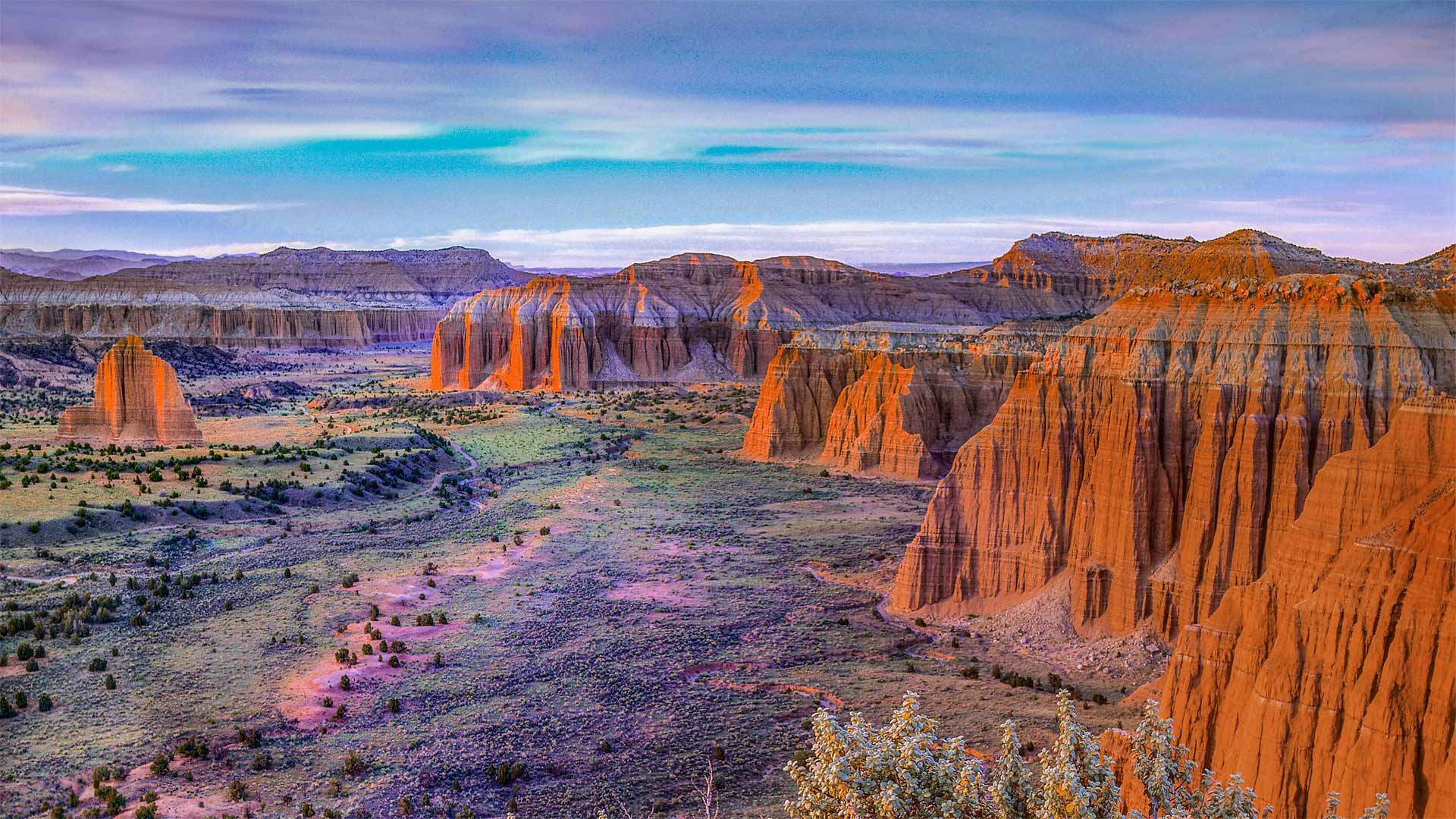
…nor the US Capitol building it's named for. Utah's Capitol Reef National Park—first established as a national monument this day in 1937—is named for its massive rock domes that reminded explorers of that famous rotunda back in Washington, DC. Why Capitol 'Reef,' though? Because the imposing formations were a major obstacle to travelers through the region, the same way a coral reef is an obstacle to sailors.
This section of the park, Cathedral Valley, is dotted with monoliths that differ from the namesake domes, instead featuring sheer, jagged walls. While most of the park rests on a steeply warped section of Earth's crust, Cathedral Valley is relatively flat—so rather than carving out gently sloping domes, water erosion here has tended to cut deep, narrow recesses down the rock faces.
这个“暗礁”离海很远…
…也不是以它命名的美国国会大厦。犹他州国会珊瑚礁国家公园于1937年作为国家纪念碑首次建立,以其巨大的岩石圆顶命名,使探险家们想起了华盛顿特区著名的圆形大厅。但为什么国会大厦是“暗礁”?因为壮观的地形是旅行者穿越该地区的主要障碍,就像珊瑚礁是海员的障碍一样。
公园的这一部分,即大教堂谷,点缀着不同于同名圆顶的巨石,取而代之的是陡峭、参差不齐的墙壁。虽然公园的大部分都坐落在地壳急剧弯曲的部分,但大教堂山谷相对平坦,因此这里的水侵蚀倾向于沿着岩石表面切割出深而窄的凹坑,而不是雕刻出缓倾斜的圆顶。
2015年4月4日摄于Tear Drop Arch附近的月全食,犹他州纪念碑谷 The total lunar eclipse of April 4, 2015, taken from near Tear Drop Arch, in western Monument Valley, Utah (© Alan Dyer/Alamy)
2015年4月4日摄于Tear Drop Arch附近的月全食,犹他州纪念碑谷 The total lunar eclipse of April 4, 2015, taken from near Tear Drop Arch, in western Monument Valley, Utah (© Alan Dyer/Alamy)
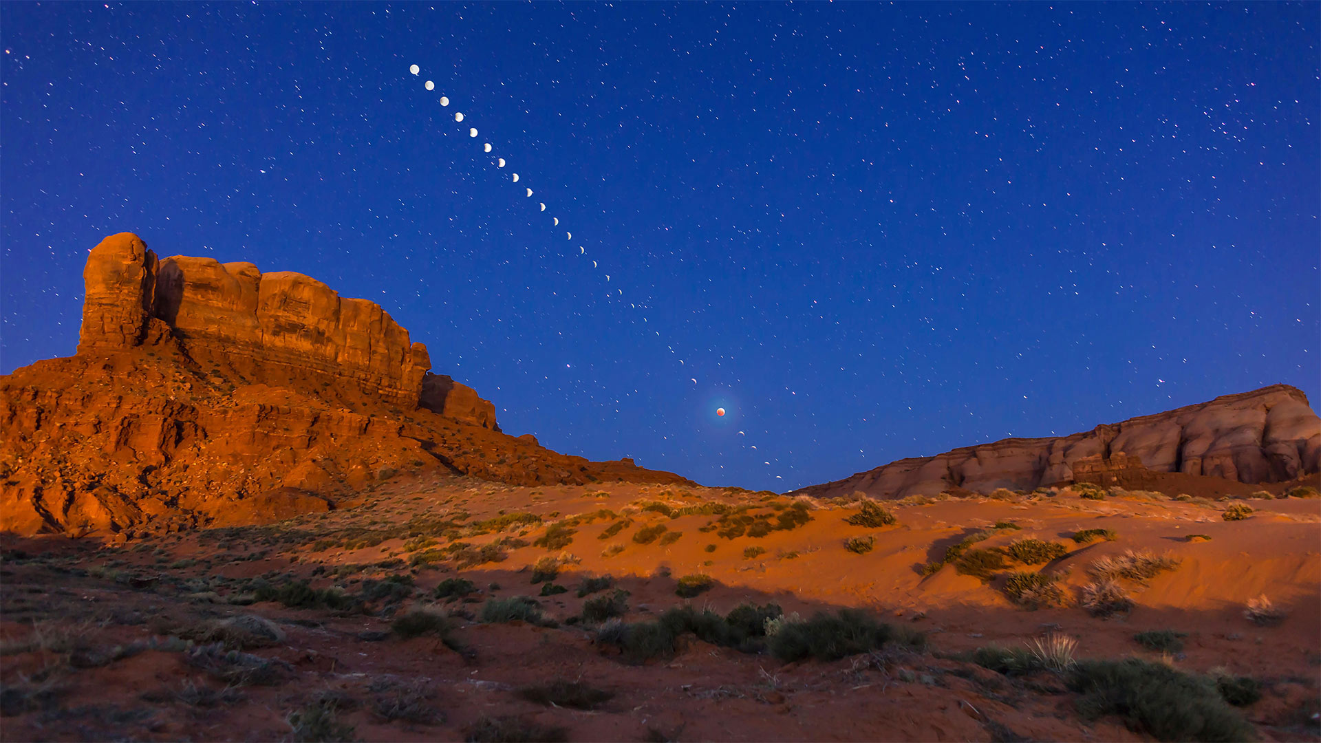
Behold the blood moon
We've heard the phrase 'many moons,' but never took it this literally. We're looking at 28 merged photos of our one and only moon over Utah's Monument Valley: 26 snapshots of its partial phases, plus two layered exposures of the eclipsing moon at center.
If the weather's agreeable tonight, folks in the US and many other parts of the world are in for a total 14-minute eclipse of the full moon similar to this one from 2015. The lunar eclipse is sometimes called a blood moon for the crimson shadow Earth casts on the lunar surface, and tonight's show carries a little extra gravity: The eclipse will occur as the moon takes its closest pass to Earth this year, making it appear large in the sky and giving it the ominous title of Super Blood Moon.
看血月
我们听过“许多月亮”这句话,但从来没有这样的字面意思。我们正在看28张合并后的照片,这是犹他州纪念碑谷上空我们唯一的一个月亮:26张部分相位的快照,加上两层日食月亮的中心曝光。
如果今晚天气宜人,美国和世界其他许多地方的人们将迎来一次14分钟的满月全食,与2015年的这次月食相似。月食有时被称为血月,因为地球在月球表面投下了深红色的阴影,今晚的节目还有一点额外的引力:今年月亮离地球最近的时候会发生月食,使它在天空中显得很大,并给它一个不祥的称号“超级血月”。
Hovenweep国家纪念碑的方塔,犹他州 Square Tower Group in Hovenweep National Monument, Utah (© Brad McGinley Photography/Getty Images)
Hovenweep国家纪念碑的方塔,犹他州 Square Tower Group in Hovenweep National Monument, Utah (© Brad McGinley Photography/Getty Images)
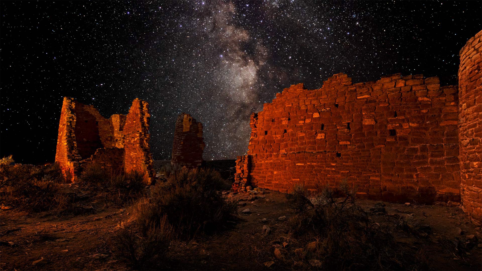
A timeless view of the night sky
The bright sweep of the Milky Way is especially vivid amid the mesas, canyons, and prehistoric towers of Hovenweep National Monument. Straddling the southern Colorado-Utah border, Hovenweep is so remote that almost no artificial light disturbs the view of star-filled skies. The dazzling nightscapes are little different from those seen by the Ancestral Puebloans who built these towers. They were a farming culture who first settled in the area roughly 1,100 years ago. By the late 1200s they numbered around 2,500 people and had built these and other structures in six different villages. Archaeologists offer several theories to explain the use of the buildings. Some may have been defensive fortifications, storage areas, homes, or any combination of these. But researchers suggest that the tower called Hovenweep Castle, seen here, was almost certainly used as a celestial observatory.
That's why we're visiting Hovenweep during International Dark Sky Week, which lasts through the weekend. Organizers of the event, held during the week of the new moon in April, encourage us to observe the beauty of the night sky without light pollution. It's easy to do here—in 2014, the International Dark Sky Association named Hovenweep a Dark Sky Park, offering protections that preserve the extraordinarily pristine skies that once shone down on the Ancestral Puebloans.
永恒的夜空
在霍文韦普国家纪念碑的台地、峡谷和史前塔楼中,银河系的明亮一扫显得尤为生动。横跨科罗拉多州和犹他州的南部边界,霍文韦普非常偏远,几乎没有人造光干扰满天星空的景象。令人眼花缭乱的夜景与建造这些塔的普埃布劳恩斯祖先所看到的几乎没有什么不同。他们是一种农业文化,大约1100年前第一次在这个地区定居。到12世纪末,他们大约有2500人,在六个不同的村庄建造了这些和其他建筑。考古学家提供了几种理论来解释这些建筑的用途。有些可能是防御工事、储存区、住宅,或这些的任何组合。但研究人员认为,在这里看到的这座名为霍文韦普城堡的塔几乎肯定是用作天文观测站的。
这就是为什么我们要在国际黑暗天空周期间参观霍文韦普,这一周将持续到整个周末。这项活动的组织者在四月的新月周举行,鼓励我们在没有光污染的情况下观察美丽的夜空。2014年,在这里很容易做到,国际黑暗天空协会将霍文韦普命名为一个黑暗天空公园,提供保护,保护曾经照耀在普韦布洛祖先身上的异常原始的天空。
布莱斯峡谷国家公园的冬天,犹他州 Winter in Bryce Canyon National Park, Utah (© Don Paulson/Danita Delimont)
布莱斯峡谷国家公园的冬天,犹他州 Winter in Bryce Canyon National Park, Utah (© Don Paulson/Danita Delimont)
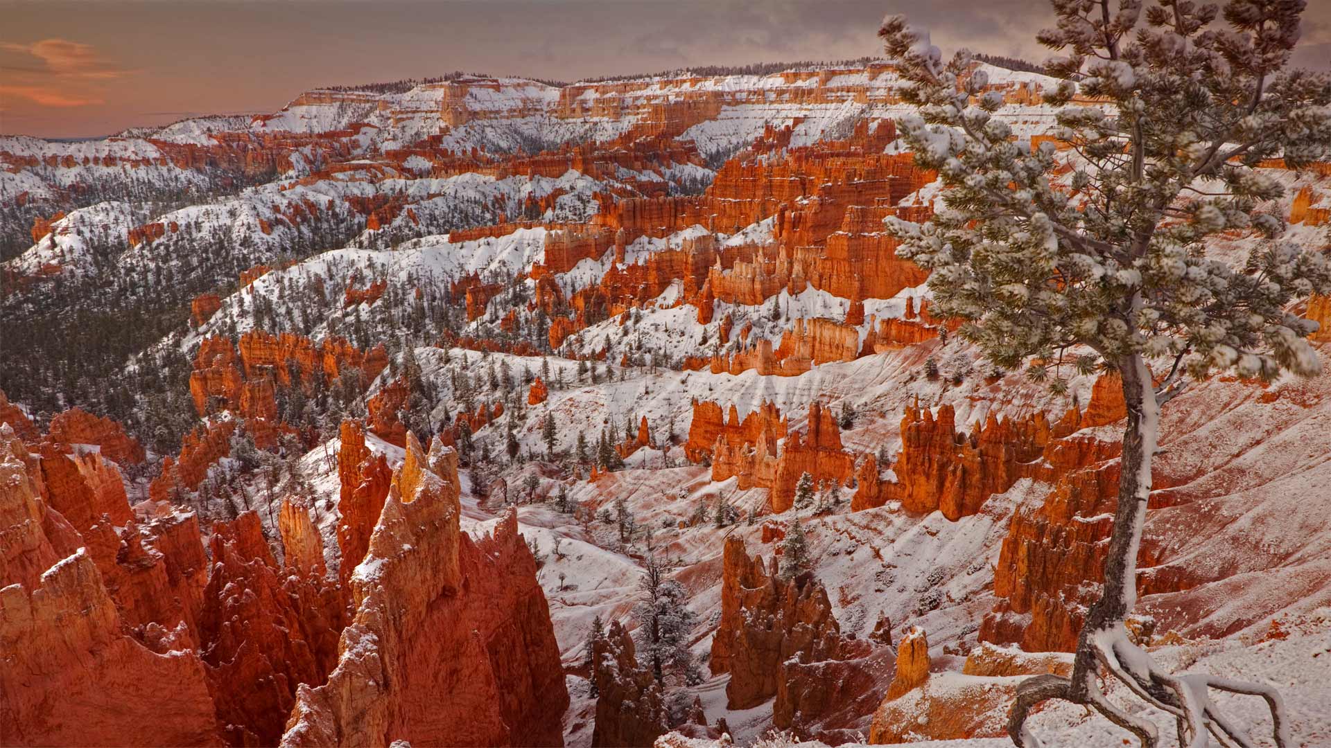
Winter in the Wild West
When considering the dramatically eroded canyons of southwestern Utah, snow may not be the first thing that comes to mind. But far-flung Bryce Canyon National Park gets plenty of the white stuff, owing to its elevation of 8,000-plus feet at the massive amphitheater's rim. The cold not only provides scenic snowy views and great cross-country skiing, it's responsible for the striking red-rock pinnacles—known as hoodoos—that make the park so unique.
High above sea level, winter in Bryce Canyon often sees daily shifts between freezing and above-freezing temperatures. Despite its name, Bryce Canyon isn't a true canyon, but is instead a collection of natural amphitheaters. The park's hoodoos formed as water seeped into massive stone plateaus, then froze and expanded to break away chunks of rock. Repeated day after day for eons, this process has left slim sections of sediment standing throughout Bryce Canyon—now the largest concentration of hoodoos in the world.
狂野西部的冬天
在说到犹他州西南部峡谷为什么受侵蚀严重时,降雪可能并不是第一个被想到的原因。 但是遥远的布莱斯峡谷国家公园(Bryce Canyon National Park)由于在大型圆形剧场的边缘海拔超过8,000英尺而获得了很多白色的东西。 寒冷不仅带来优美的雪景和越野滑雪,而且还造成了令人惊叹的红岩峰(称为石林),使公园如此独特。
布莱斯峡谷的冬天海拔很高,每天都会出现冰点和冰点以上温度的变化。尽管它的名字包含峡谷,但布莱斯峡谷不是一个真正的峡谷,而是一个自然露天剧场的集合。公园的石林随着水渗入巨大的石制高原而形成,然后冻结并扩大以分裂成块的岩石。 这一过程日复一日地重复了亿万年,留下了遍布布莱斯峡谷的薄薄的沉积物,现在布莱斯峡谷是世界上最大的石林聚集地。
锡安国家公园中的Walter's Wiggles小径,犹他州 Walter's Wiggles trail in Zion National Park, Utah (© Dennis Frates/Alamy)
锡安国家公园中的Walter's Wiggles小径,犹他州 Walter's Wiggles trail in Zion National Park, Utah (© Dennis Frates/Alamy)
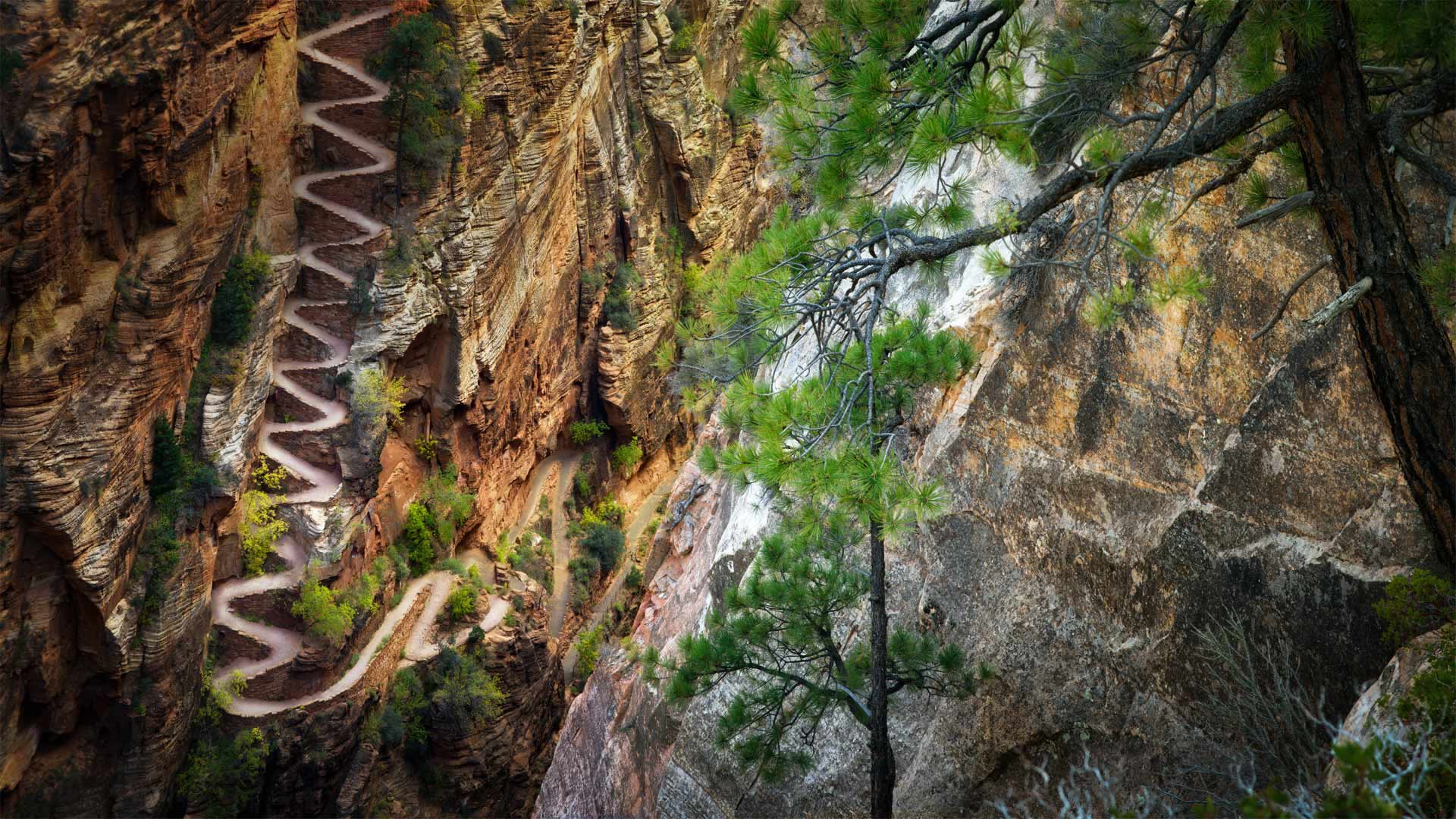
The long and wiggling path
In 1926, Walter Ruesch, the first superintendent of Zion National Park oversaw the construction of one of the park's most ambitious trails. It took 258 helicopter flights to haul in the concrete needed to construct the steep 21-switchback trail out of Refrigerator Canyon up to Angels Landing, but the view from the top makes it all worthwhile. Walter's Wiggles, one of the most difficult and dangerous trails in the park, was added to the National Registry of Historic Places in 1987.
But you don't need to haul tons of concrete or carve into the sheer sides of a remote canyon help carry on the tradition of trail-building. Today is National Trails Day, a day 'to come together in partnership to advocate for, maintain, and clean up public lands and trails.'
Usually this means heading out to a local wilderness area and joining others to clear or maintain some trails, but this year (as you may have noticed) is a little different. The American Hiking Society has organized a digital campaign to inspire individuals to unite for the protection of trails and access to public lands—without endangering one another.
两名山地车骑手在白缘公路上沿着谢福小道的转弯处骑行 ,犹他州峡谷地国家公园 (© Grant Ordelheide/Tandem Stills + Motion)
两名山地车骑手在白缘公路上沿着谢福小道的转弯处骑行 ,犹他州峡谷地国家公园 Two mountain bike riders make their way down the Shafer Trail switchbacks on White Rim Road in Canyonlands National Park, Utah (© Grant Ordelheide/Tandem Stills + Motion)
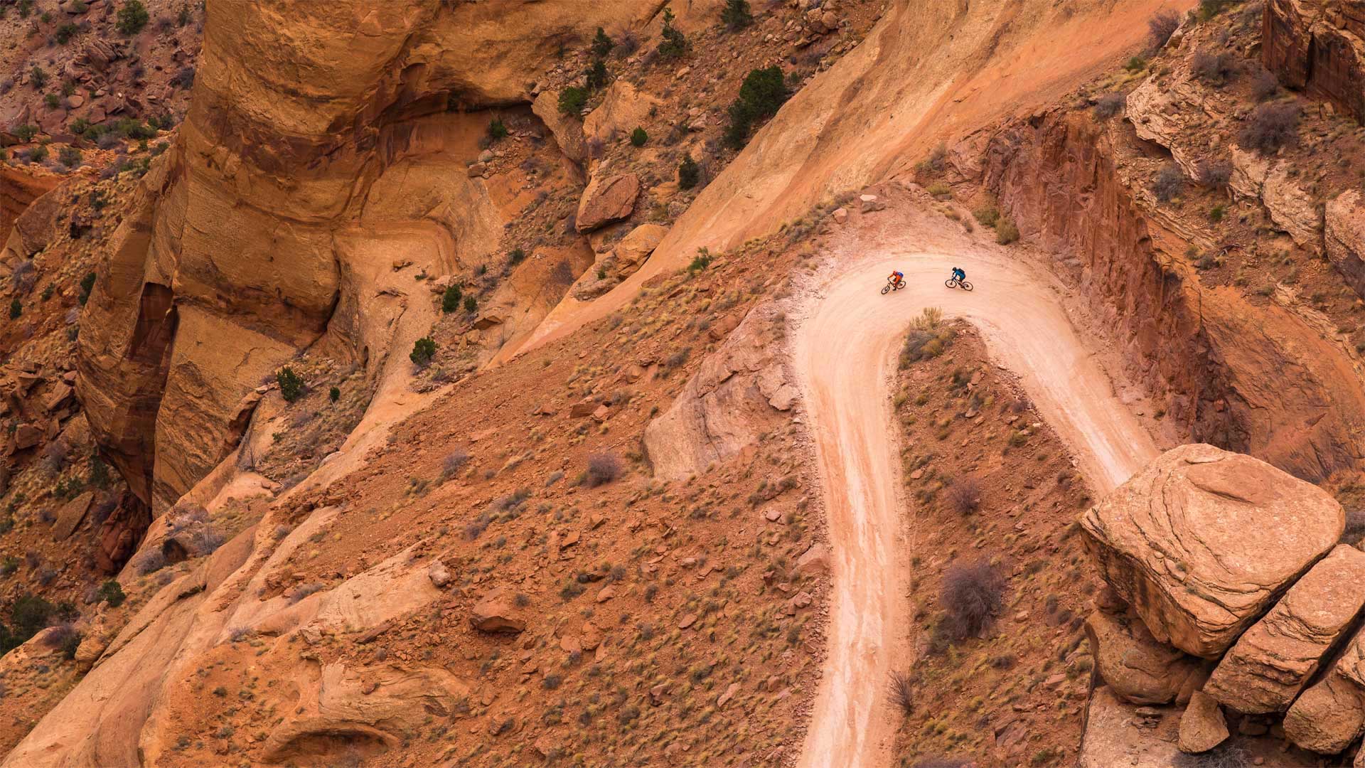
For the love of bikes
In honor of World Bicycle Day, we share a bird’s-eye view of two mountain bikers traveling on the Shafer Trail switchbacks of White Rim Road in Canyonlands National Park in Utah. In 2018, the UN officially recognized 'the uniqueness, longevity and versatility of the Bicycle, which has been in use for two centuries, and that it is a simple, affordable, reliable, clean and environmentally fit sustainable means of transportation.'
German Karl von Drais is credited with creating the first version of a bike in 1817; it was a heavy wooden contraption that the rider pushed forward with his or her feet. It had many names—the 'draisine,' velocipede, and dandy horse--and it was a fad for a few years, but eventually the bike was banned because it was too dangerous (no brakes!).
The bicycle has gone through many iterations since then, from the less-than-comfortable 'boneshaker' in the 1860s, followed by the 'penny-farthing' with its huge front wheel, to today’s popular fatbikes and e-bikes. During one of America’s biking booms, in the 1970s, more bikes were sold than cars. Today bicycles remain as popular as ever, so whether it’s for recreation or transportation, the bicycle is here to stay.
天生桥国家保护区中的sipapu桥,犹他州 Sipapu Bridge in Natural Bridges National Monument, Utah (© Fyletto/Getty Images)
天生桥国家保护区中的sipapu桥,犹他州 Sipapu Bridge in Natural Bridges National Monument, Utah (© Fyletto/Getty Images)
Bridges to the past
The story of this sandstone formation in southeastern Utah's Natural Bridges National Monument begins around 10 million years ago. That's when tectonic shifts began slowly lifting the 130,000 square-mile Colorado Plateau above the surrounding plains. In ensuing eons, the Colorado River's many streams eroded the elevated land, threading it with deep canyons. When water broke through one canyon wall into another canyon, sometimes a natural bridge like this one remained above the breach.
The national monument—Utah's first, proclaimed by President Theodore Roosevelt on April 16, 1908—protects three major bridges: Sipapu (pictured, and the largest), Kachina, and Owachomo. But even the president's pen can't stop the slow ravages of time. In a 1992 rockfall, Kachina slimmed down by 4,000 tons—and the remains of many fallen bridges dot the monument, hinting at the main attractions' eventual fate.