标签 法国 下的文章
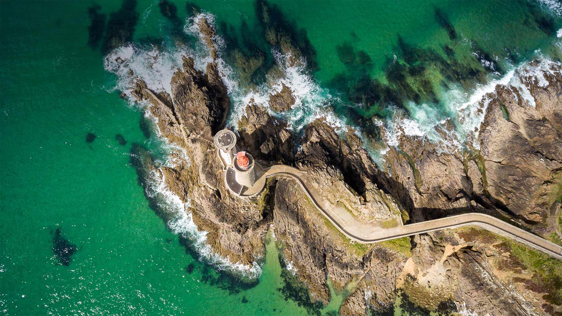
港边的小米努灯塔,法国布雷斯特 Petit Minou Lighthouse in the roadstead of Brest, Finistère, France (© Mathieu Rivrin/Getty Images)
港边的小米努灯塔,法国布雷斯特 Petit Minou Lighthouse in the roadstead of Brest, Finistère, France (© Mathieu Rivrin/Getty Images)
Ambassadors of the airwaves
Today we're visiting the Petit Minou Lighthouse on the coast of northwest France to mark the relationship between lighthouses and the 20th-century technology of amateur radio, commonly known as 'ham' radio. The International Lighthouse and Lightship Weekend (ILLW) is an event set up every August by a group of amateur radio operators from nearly 100 countries. Events for this ILLW weekend are organized online with individual events held at various lighthouses around the world, where 'ham' radio operators gather to broadcast and engage with fellow enthusiasts. The aim of these gatherings is to not only foster goodwill for ham radio around the world, but also to promote awareness of lighthouse preservation and restoration, and to honor the legacy these solitary structures have had on our collective maritime heritage.
广播大使
今天,我们将参观位于法国西北部海岸的小米诺灯塔,以纪念灯塔与20世纪业余无线电技术(俗称“业余无线电”)之间的关系。国际灯塔和灯船周末(ILLW)是每年8月由来自近100个国家的业余无线电操作员组织的活动。本ILLW周末的活动在网上组织,在世界各地的灯塔举办个人活动,“火腿”电台运营商聚集在那里,与其他爱好者一起广播和参与。这些集会的目的不仅是为了在全世界培养对哈姆广播电台的善意,而且也是为了提高人们对灯塔保护和修复的认识,并纪念这些孤零零的建筑在我们的集体海洋遗产中留下的遗产。
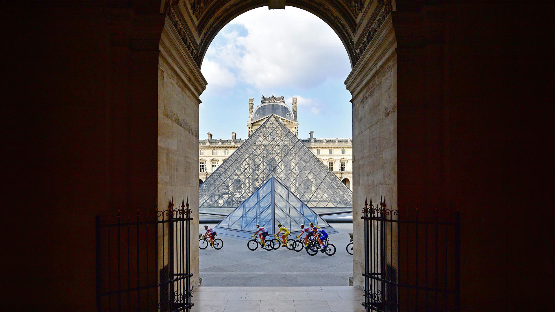
Tour de France riders in front of the Louvre Pyramid and museum in Paris, France, during the 2020 race (© Martin Bureau/AFP via Getty Images)
Tour de France riders in front of the Louvre Pyramid and museum in Paris, France, during the 2020 race (© Martin Bureau/AFP via Getty Images)
Grand finish of Le Tour
After a three-week jaunt around France, cycling's most prestigious race concludes today with a triumphant procession into Paris before a sprint finish on the iconic Champs-Élysées. The 21st and final stage of this year's Tour de France—the 108th edition of the famous event—begins in Chatou, a town in the western suburbs of Paris along the river Seine. Tour tradition dictates the overall race leader isn't challenged on the last day, so it starts out as a victory parade for the champion-elect, who will be wearing a yellow jersey, posing for pictures, and sipping a glass of champagne along the route. But when the riders reach the heart of Paris, the pace picks up as they dash around the Champs-Élysées, a tree-lined promenade often described as the 'most beautiful avenue in the world.'
The peleton—a large group of riders bunched together—enters the Champs-Élysées via the courtyards of the Louvre Palace, passing directly by its famous glass pyramid, as shown on our homepage. They then complete an eight-lap circuit, which takes them on a sightseeing tour around the Arc de Triomphe, past the Tuileries Garden, across the Place de la Concorde—the largest square in Paris—and back up the cobblestones of the Champs-Élysées, which is French for 'Elysian Fields,' the final resting place for heroes from Greek mythology. Quite the place then to finish a relentless race that covers more than 2,000 miles and includes brutal climbs in the Alps and the Pyrenees. Chapeau!
乐游大结局
经过为期三周的环法之旅,这场最负盛名的自行车赛今天以胜利的游行队伍结束,进入巴黎,然后在标志性的Champs-Élysées进行冲刺。第108届环法自行车赛是今年环法自行车赛的第21个也是最后一个阶段,在巴黎西郊塞纳河沿岸的一个小镇Chatou举行。巡回赛的传统规定,总的领队在最后一天不会受到挑战,所以这是冠军当选人的胜利游行,他将穿着黄色球衣,摆姿势拍照,沿途啜饮一杯香槟。但当骑手们到达巴黎市中心时,他们在香榭丽舍大道(Champs-Élysées)周围奔跑时,步伐加快了,这是一条绿树成荫的长廊,常被称为“世界上最美丽的大道”
佩尔顿——一大群骑手聚集在一起,通过卢浮宫的庭院进入香榭丽舍,直接经过著名的玻璃金字塔,如我们的主页所示。然后,他们完成了一个八圈的线路,带着他们游览凯旋门,经过杜伊勒里花园,穿过巴黎最大的广场协和广场(Place de la Concorde),回到香榭丽舍(Champs-Élysées)的鹅卵石上,香榭丽舍是“极乐世界”(Elysian Fields)的法语意思,这是希腊神话中英雄们的最后安息之地。这是一个很好的地方来完成一个无情的比赛,覆盖了2000多英里,包括在阿尔卑斯山和比利牛斯山残酷的攀登。起首!
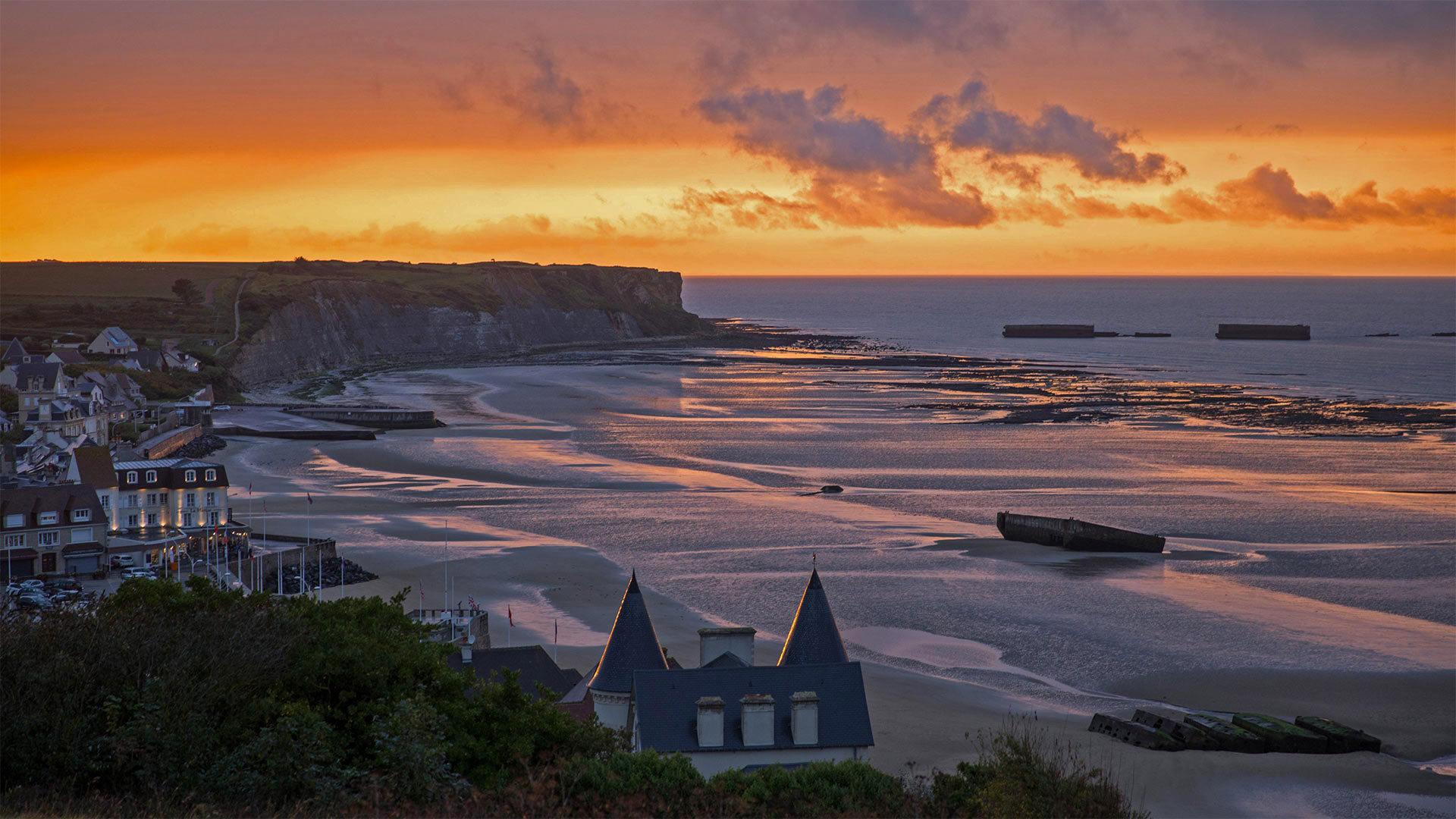
阿罗芒什莱班的桑树港,法国诺曼底 Mulberry Harbour in Arromanches-les-Bains, Normandy, France (© agefotostock/Alamy)
阿罗芒什莱班的桑树港,法国诺曼底 Mulberry Harbour in Arromanches-les-Bains, Normandy, France (© agefotostock/Alamy)
On this shore, history was made
As the sun sets on a beach in Normandy, France, what appear to be working barges and boats offshore are actually the remnants of Mulberry Harbours, temporary portable harbors created by the Allies during World War II. Their story begins 47 years ago today, on D-Day, when the first of the Allied troops touched down on the Nazi-occupied beaches at Normandy. After the Allies successfully held the beachheads, the Mulberries were towed into place so the artificial harbors could provide the port facilities necessary to offload the thousands of men and vehicles, and tons of supplies necessary to sustain the effort to drive the Germans out of France.
Two Mulberry Harbours were built for D-Day. The one known as Mulberry A was constructed off Omaha Beach to aid US forces. Mulberry B was built here, off Gold Beach at Arromanches to supply British and Canadian troops. Mulberry A was destroyed in a storm just a few days after it was built, but Mulberry B was operational for 10 months after the landings, providing crucial infrastructure to the Allied operation. The innovative feat of military engineering enabled the largest seaborne invasion in history, which in turn laid the foundations of the Allied victory on the Western Front.
在这片海岸上,创造了历史
当太阳落在法国诺曼底的一个海滩上时,看似在海上工作的驳船和船只实际上是桑葚港的残余物,桑葚港是二战期间盟军建立的临时便携式港口。他们的故事开始于47年前的今天,也就是诺曼底登陆日,当时盟军的第一支部队在诺曼底登陆了纳粹占领的海滩。盟军成功占领滩头阵地后,桑葚被拖到适当的地方,这样人工港口就可以提供必要的港口设施,卸载成千上万的人和车辆,并提供数吨必要的物资,以维持将德国人赶出法国的努力。
为D日建造了两个桑葚港。这座名为“桑葚A”的建筑是在奥马哈海滩附近建造的,目的是帮助美军。Mulberry B是在阿罗曼奇斯的黄金海滩附近建造的,为英国和加拿大军队提供补给。桑葚A号在建成后几天就在暴风雨中被毁,但桑葚B号在登陆后的10个月内仍在运行,为盟军的行动提供了至关重要的基础设施。军事工程的创新成就促成了历史上最大规模的海上入侵,进而奠定了盟军在西线取得胜利的基础。
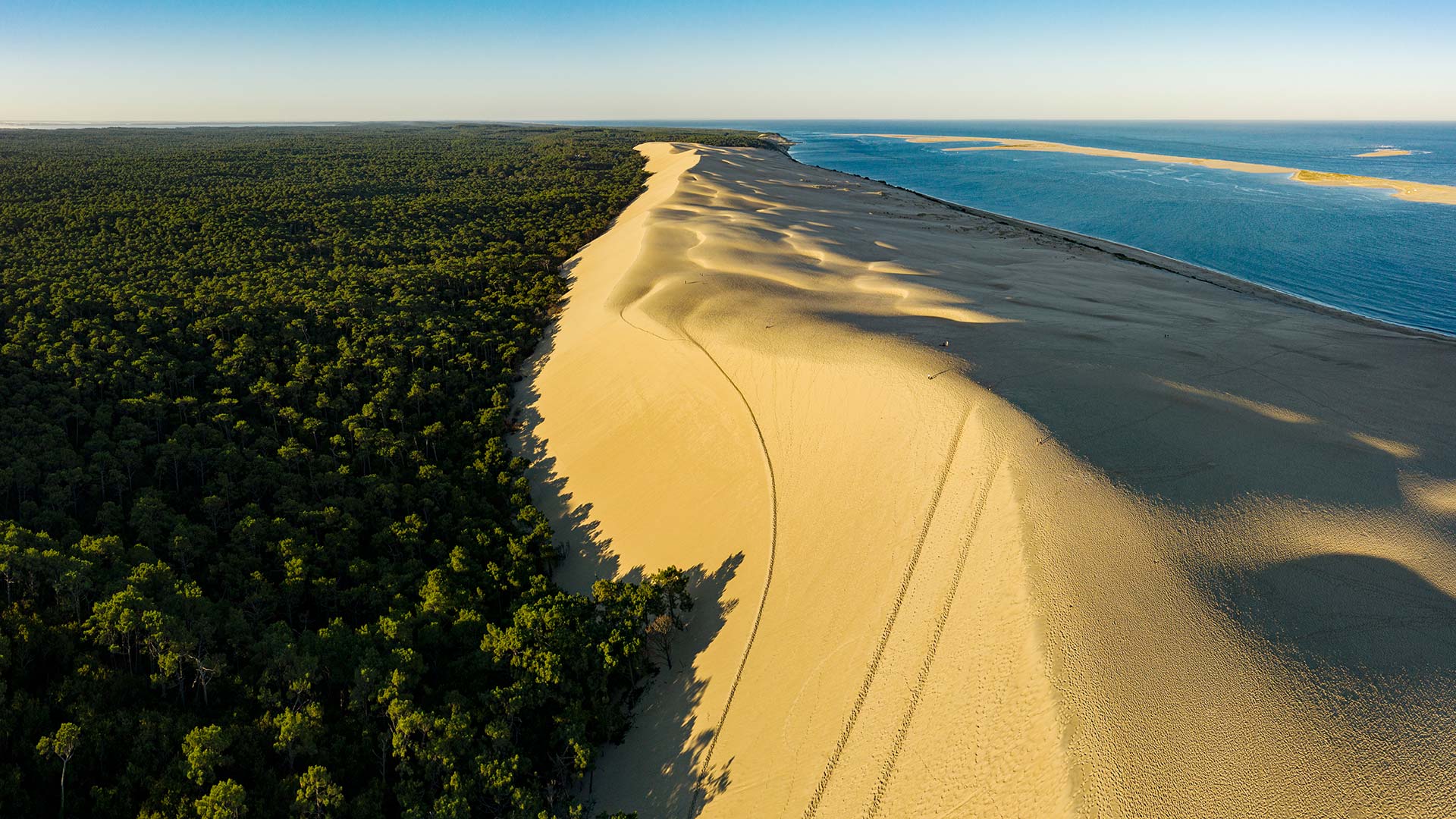
法国西南部阿卡雄湾的皮拉沙丘 The Dune of Pilat in Arcachon Bay, southwest France (© aluxum/iStock/Getty Images Plus)
法国西南部阿卡雄湾的皮拉沙丘 The Dune of Pilat in Arcachon Bay, southwest France (© aluxum/iStock/Getty Images Plus)
Against all odds
Whether you've been there or not, you will no doubt recognize the famous Dune of Pilat, stretching all the way across our image today. Located in the Gironde, at the entrance to the Arcachon basin, near the town of La Teste de Buche, the one known as the white lady has almost perfect measurements. At 106 meters high, 2.7 kilometers long, and 60 million cubic meters of sand, the Dune of Pilat is the highest dune in Europe. Belonging to the coastal dunes of Aquitaine, the Dune of Pilat is to date the only one of this system still in motion; each year, it moves 1 to 5 meters east, driven by winds and tides, gradually covering the adjoining maritime pine forest.
不择手段
无论你是否去过那里,你都会毫无疑问地认出著名的比拉特沙丘,它一直延伸到我们今天的形象。坐落在吉伦德,在阿卡松盆地的入口处,靠近拉斯特德布赫镇,一个被称为白女士有几乎完美的测量。皮拉特沙丘高106米,长2.7公里,沙量6000万立方米,是欧洲最高的沙丘。皮拉特沙丘属于阿基坦海岸沙丘,是迄今为止该系统中唯一仍在运动的沙丘;每年,它在风和潮汐的推动下向东移动1至5米,逐渐覆盖邻近的海洋松林。
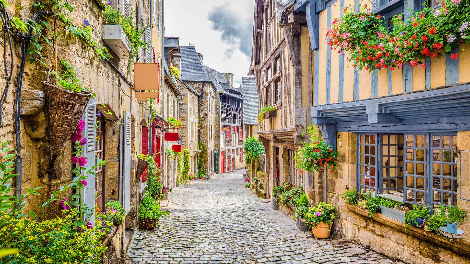
Dinan镇的鹅卵石铺成的街道,法国布列塔尼 (© Scott Wilson/Alamy)
汝拉山中的Chateau de Joux堡,法国 Château de Joux in the Jura mountains of France (© Ivoha/Alamy)
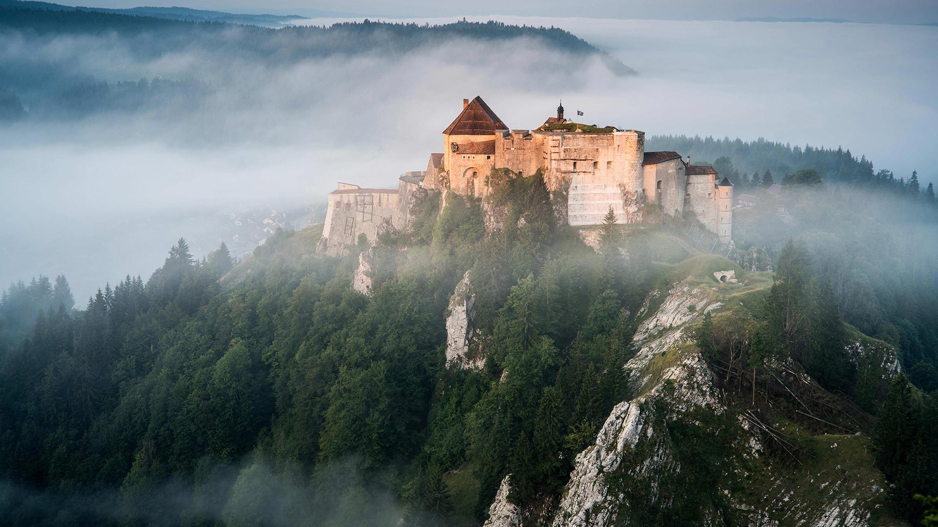
汝拉山中的Chateau de Joux堡,法国 Château de Joux in the Jura mountains of France (© Ivoha/Alamy)
Military art
Overlooking the valley linking France to Switzerland (the Cluse de Pontarlier), Joux castle – with its keep, towers, drawbridges, surrounding walls and fort – offers fantastic evidence of the way fortifications have developed over the years. Built in the 11th century, then modified by Vauban in the 17th century, people will discover 10 centuries of history there.
军事艺术
俯瞰连接法国和瑞士的山谷(Cluse de Pontarlier),Joux castle及其要塞、塔楼、吊桥、围墙和堡垒为多年来防御工事的发展提供了极好的证据。建于11世纪,17世纪被沃邦修缮,人们将在那里发现10个世纪的历史。
里昂天文钟,法国里昂 Lyon astronomical clock, Lyon, France (© kyolshin/Alamy)
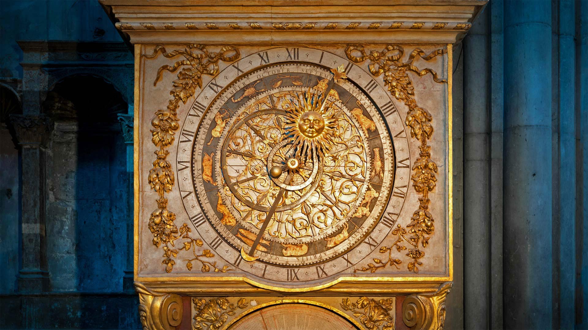
里昂天文钟,法国里昂 Lyon astronomical clock, Lyon, France (© kyolshin/Alamy)
Perfect timing
If the first day of daylight saving time doesn't have you springing for joy, this towering timekeeper might be more your speed. The astronomical clock at Lyon Cathedral in France was built in 1660, long before daylight time became widely adopted in the 20th century. The clock's intersecting hands and dials don't just tell time, they form a flattened model of our planet that tracks the positions of the sun and moon relative to Earth. The zodiac dial, offset to account for the planet's rotational tilt, shows the star sign currently in season.
All this movement of circles and spheres might call to mind another observance of the day: March 14 is Pi Day, in celebration of the mathematical constant pi (aka π, or roughly 3.14). You remember pi from geometry class: It expresses the ratio of the distance around a circle to the distance across it. So it was essential to ancient astronomers who mapped these celestial workings, as well as to designers of intricate machines that simulate the circling heavens.
Wow, you kept reading through all the math talk? You deserve a sweet payoff. Why not slice into our Pi Day pie quiz?
完美的时机
如果夏令时的第一天没有让你欣喜若狂,那么这个高耸的计时员可能会比你更快。法国里昂大教堂的天文钟建于1660年,远远早于20世纪白天被广泛采用。时钟交叉的指针和刻度盘不仅告诉我们时间,它们还形成了一个地球的平面模型,跟踪太阳和月球相对于地球的位置。黄道十二宫的刻度盘,抵消了这颗行星的自转倾斜,显示了目前正处于这个季节的星座。
所有这些圆圈和球体的运动可能会让人想起另一个纪念日:3月14日是π日,庆祝数学常数π(又名π,约3.14)。您还记得几何类中的pi:它表示圆周围的距离与穿过圆的距离之比。因此,这对绘制这些天体运行图的古代天文学家,以及模拟环绕天空的复杂机器的设计者来说,都是至关重要的。
哇,你一直在读数学课?你应该得到一个甜蜜的回报。为什么不加入我们的派日测验呢?
北孚日地区自然公园,法国 Northern Vosges Regional Nature Park, France (© Michel Rauch/Minden Pictures)
北孚日地区自然公园,法国 Northern Vosges Regional Nature Park, France (© Michel Rauch/Minden Pictures)
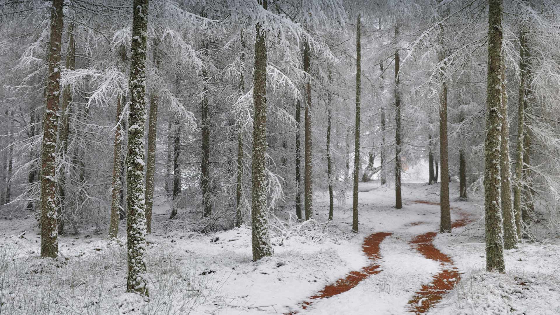
Where is this wintry road?
This wintry, wooded scene comes from the Northern Vosges Regional Nature Park in northeastern France, one of the country's most beautiful and pristine examples of natural beauty. The park, established in 1976, is over 322,000 acres in size, 65% of which is covered in forest, including the species of larch tree seen here. These larches are native to many of the mountains of central Europe, such as the Alps, Carpathians, and the Pyrenees.
Even though the area here is dotted with villages, because so much of its natural beauty remains, this rural park was named by UNESCO as one of its World Biosphere Reserves. UNESCO studies these reserves to trace the interaction between social systems and the natural world. This biodiversity of the Northern Vosges includes a wide array of forests and wetlands, fauna and flora, but also contains over 100 municipalities, farmlands and even five structures left over from France's infamous WWII-era Maginot Line of fortifications built to deter invading German forces. With its many hiking trails, the Northern Vosges region is a favorite for outdoor enthusiasts and nature lovers.
这条冬天的路在哪里?
这个寒冬里树木繁茂的场景来自法国东北部的北部沃斯地区自然公园,这里是法国最美丽和最原始的自然美景之一。这个公园建于1976年,占地32.2万英亩,其中65%被森林覆盖,包括这里看到的落叶松。这些落叶松原产于中欧的许多山脉,如阿尔卑斯山、喀尔巴阡山和比利牛斯山。
尽管这里到处都是村庄,但由于保留了太多的自然美景,这个乡村公园被联合国教科文组织命名为世界生物圈保护区之一。联合国教科文组织对这些保护区进行研究,以追踪社会系统与自然世界之间的相互作用。这种生物多样性的北部沃斯包括广泛的森林和湿地,动植物群,但也包含了100多个城市,农田,甚至还包括法国二战时期臭名昭著的马其诺线遗留下来的防御工事,目的是阻止入侵的德国军队。北沃斯地区有许多徒步旅行路线,是户外爱好者和自然爱好者的最爱。
鸟瞰勃朗峰山脉中的南针峰,法国 Aerial view of the Aiguille du Midi in the Mont Blanc massif, France (© Amazing Aerial Agency/Offset by Shutterstock)

鸟瞰勃朗峰山脉中的南针峰,法国 Aerial view of the Aiguille du Midi in the Mont Blanc massif, France (© Amazing Aerial Agency/Offset by Shutterstock)
Atop the Needle of Chamonix
With these dramatic clouds, the shard-like pinnacles of the Aiguille du Midi (Needle of Midday) resemble the spires of a ruined Alpine cathedral. This is just one of the many spectacular peaks of the Mont Blanc massif, the storied Alps range in eastern France that stretches across the border into Italy and Switzerland. It was here in France's Chamonix valley that mountaineering first became a sport in the mid-1700s. This dramatic peak was summited in 1818, a feat that helped to popularize mountain climbing throughout Europe.
Skilled mountaineers still climb the Aiguille du Midi, but these days the rest of us can choose to reach the top the easy way. A cable car to the summit went into service in 1955 and is still considered the highest vertical-ascent cable car in the world. Visitors can climb aboard in the valley town of Chamonix and ride to the top of the Aiguille du Midi—more than 9,000 vertical feet—in under 20 minutes. The cable cars and viewing platform were upgraded in recent years, and a new feature called 'Step into the Void' was added in 2013. It allows courageous tourists to stand in a glass room jutting out from the mountain and look down through the glass floor with more than 3,000 feet of free air under their feet.
阿尔卑斯山Cheran峡谷中流淌的河流,法国萨瓦 River running through Cheran Gorges, Alps, Savoie, France (© Jean-Philippe Delobelle/Minden)
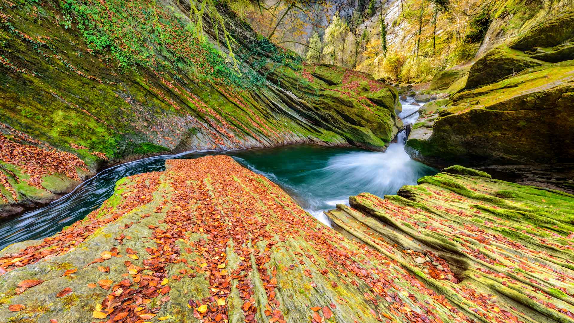
阿尔卑斯山Cheran峡谷中流淌的河流,法国萨瓦 River running through Cheran Gorges, Alps, Savoie, France (© Jean-Philippe Delobelle/Minden)
A very precious river
Autumn has settled here on the banks of the Chéran, a river of the Northern Prealps, a small region of Savoy, France. Nicknamed "the pearl of the Bauges" because of its remarkable character and the beauty of the landscapes it crosses, this mountain stream is conducive to many activities, including one you don't expect!
Gold miners have been visiting the Chéran since the middle ages – the 24-carat river known as one of the purest in the world - however the inhabitants of the region are confident that there will be no gold rush here.