维也纳美景宫的圣诞市场,奥地利 Christmas market at Belvedere in Vienna, Austria (© Diyana Dimitrova/Alamy)
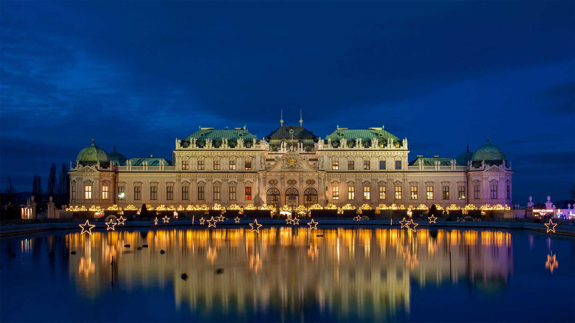
维也纳美景宫的圣诞市场,奥地利 Christmas market at Belvedere in Vienna, Austria (© Diyana Dimitrova/Alamy)
圣诞节的倒影 Reflecting on Christmas
维也纳Belvedere的圣诞集市
圣诞集市赢得了节日的三重大奖:你可以买到有趣的、通常是手工制作的礼物,它们位于欧洲风景如画、浪漫的城镇和村庄,它们用热葡萄酒和当地美食吸引你。有什么不喜欢的?圣诞集市,或称为“维纳赫斯多夫”,是欧洲最古老的降临节之一。
我们的照片显示了奥地利的Belevedere圣诞市场,位于多瑙河对岸,上贝尔维代尔(Upper Belvedere)郊外,是该酒店的两座宫殿之一。如果你去逛圣诞集市,花点时间逛一逛,看看这个季节的所有景色和气味。在维也纳,这座建筑令人印象深刻的城市在节日期间全力以赴,灯光、装饰和音乐一应俱全,而丽城宫则是一个颇具戏剧性的背景。
Christmas market at Belvedere in Vienna
Christmas markets win the holiday trifecta: You can buy interesting, often hand-crafted gifts, they are set in picturesque, romantic towns and villages in Europe, and they tempt you with mulled wine and local delicacies. What's not to like? Christmas markets, or 'Weihnachtsdorf,' are one of Europe's oldest Advent events.
Our photo shows Austria's Belevedere Christmas market from across the Danube River, outside Upper Belvedere, one of two palaces on the property. If you visit a Christmas market, make the time to stroll, taking in all the sights and smells of the season. In Vienna, the architecturally impressive city goes all out for the holidays, with lights, decorations, and music, and the Belvedere Palace is a suitably dramatic backdrop.
杜德萨加尔瀑布,印度果阿 (© Lucky-photographer/Getty Images)
博罗韦茨,保加利亚 Borovets, Bulgaria (© Grigor Ivanov/Cavan Images)
博罗韦茨,保加利亚 Borovets, Bulgaria (© Grigor Ivanov/Cavan Images)
冬季仙境 Winter wonderland for your wallet
保加利亚Borovets滑雪场
Borovets是保加利亚最古老的冬季滑雪胜地,成立于1896年。它是一个更便宜的欧洲滑雪胜地,而不是阿尔卑斯山上更昂贵的滑雪胜地,特别是对于滑雪新手和那些在斜坡上寻找乐趣而不花大钱的人来说。
该度假区曾被保加利亚皇室用作狩猎场。Borovets覆盖了保加利亚和巴尔干半岛最高的山峰Musala Peak的山麓和山脊,位于国家首都索非亚以南几十英里的东部Rila山脉。
Borovets ski resort in Bulgaria
Borovets is Bulgaria's oldest winter resort, established in 1896. It's a cheaper European skiing alternative to the more expensive resorts in the Alps, especially for novice skiers and those looking for fun on the slopes without shelling out the big bucks.
The resort area was once used by Bulgarian royalty as hunting grounds. Borovets covers the foothills and ridge-spine of Musala Peak, the highest mountain in Bulgaria and the Balkans, in the eastern Rila Mountains only a few dozen miles south of the national capital, Sofia.
大帕拉迪索国家公园,意大利 Agnel Lake and Serrù Lake, Gran Paradiso National Park, Italy (© agustavop/Getty Images)
大帕拉迪索国家公园,意大利 Agnel Lake and Serrù Lake, Gran Paradiso National Park, Italy (© agustavop/Getty Images)
意大利最古老的国家公园 In the oldest national park in Italy
格兰帕拉迪索国家公园,意大利
格兰帕拉迪索国家公园(Gran Paradiso National Park)是位于格拉安阿尔卑斯山的一座意大利国家公园,位于奥斯塔山谷和皮埃蒙特地区之间。公园以位于公园内的格兰帕拉迪索山命名;它与法国瓦努瓦兹国家公园毗邻。
格兰帕拉迪索也有丰富的河流、瀑布,当然还有湖泊,就像照片中描绘的那样。Agnel和Serrù实际上是两个人工流域,为各种水力发电厂供水,最著名的是1969年电影《意大利工作》的最后一幕。
Gran Paradiso National Park, Italy
Gran Paradiso National Park is an Italian national park in the Graian Alps, between the Aosta Valley and Piedmont regions. The park is named after Gran Paradiso mountain, which is located in the park; it is contiguous with the French Vanoise National Park.
The Gran Paradiso is also rich in rivers, waterfalls and of course lakes, like those portrayed in the photo. Agnel and Serrù are actually two artificial basins that feed various hydroelectric plants, famous above all for having served as the setting for the final scene of the 1969 film The Italian Job.
哈尔施塔特,奥地利 Hallstatt, Austria (© Jon Arnold Images Ltd/Alamy)
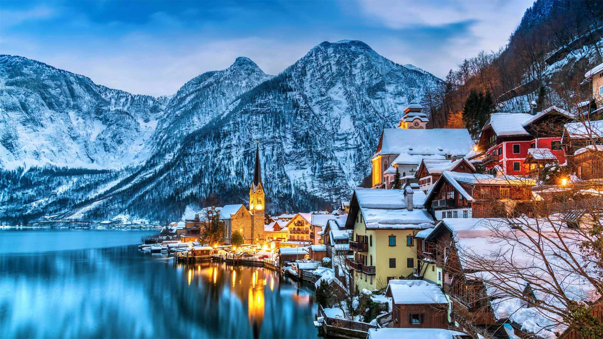
哈尔施塔特,奥地利 Hallstatt, Austria (© Jon Arnold Images Ltd/Alamy)
哈尔施塔特,奥地利 A city so nice they made it twice
奥地利哈尔施塔特
奥地利哈尔施塔特村周围山丘上的盐矿被认为是世界上最古老的盐矿之一。盐曾经是哈尔施塔特经济的支柱。如今,这些矿山成为一个受欢迎的旅游景点。这个故事书村庄吸引了大量游客,以至于被认为是过度旅游的地区。该镇已设法限制每天可以参观的人数。哈尔施塔特的魅力是如此之大,以至于2011年在中国广东省建造了一座完全相同的小镇。所以,如果他们不能把你挤到哈尔施塔特,也许你可以跳到中国版。
Hallstatt, Austria
The salt mines in the hills surrounding the village of Hallstatt, Austria, are thought to be some of the oldest in the world. Salt was once the backbone of Hallstatt's economy. Today the mines make a popular tourist attraction. This storybook village draws in masses of visitors, so many that it is considered an area of over-tourism. The town has sought to limit the number of people who can visit each day. Hallstatt's charms were so considerable that an identical recreation of the town was built in Guangdong, China, in 2011. So, if they can't squeeze you into Hallstatt, perhaps you can pop over to China's version.
泰根塞山脉Roßstein山顶的景色,德国巴伐利亚州 View from the summit of Roßstein mountain, Bavaria, Germany (© Christian Bäck/eStock Photo)
泰根塞山脉Roßstein山顶的景色,德国巴伐利亚州 View from the summit of Roßstein mountain, Bavaria, Germany (© Christian Bäck/eStock Photo)
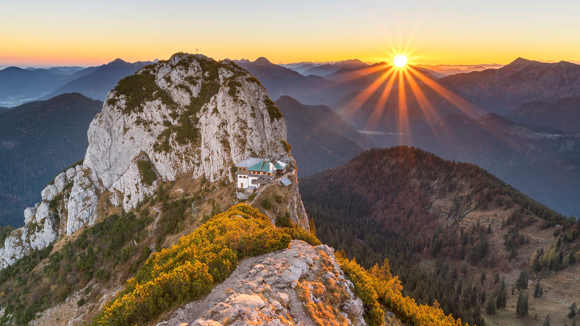
国际山岳日 International Mountain Day
特根塞山脉
山脉是我们世界上最有趣的地质特征之一。山脉也成为无数代人类的游乐场和崇拜场所,这清楚地证明了地球表面下发生的巨大变化。几千年来,任何对如此多的人和文化如此重要的东西都值得纪念。因此,在12月11日,我们庆祝国际山地日!
我们的旅程将带我们前往位于特根塞山脉的上巴伐利亚州,这是一个属于巴伐利亚前阿尔卑斯山脉的山区。这张照片显示了从罗ß斯坦河(1698米)到布赫斯坦河(1701米)的景色。这两座山形成了一座双峰,泰格恩塞·吕特(Tegernsee Hütte)就坐落在它的马鞍上。该避难所于5月中旬至11月初开放,为徒步旅行者和登山者提供食宿。由于其暴露的位置,其位置通常被称为“鹰巢”。
Tegernsee Mountains
Mountains are some of the most interesting geological features that our world has to offer. Clear proof of the massive changes that happen beneath the surface of our planet, mountains have also served as playgrounds and places of worship for countless generations of humans. Anything that’s been such a mainstay for so many people and cultures through millennia is worth commemorating. So on December 11, we celebrate International Mountain Day!
Our excursion takes us to Upper Bavaria in the Tegernsee Mountains, a mountain region that belongs to the Bavarian Pre-Alps. The photo shows the view from the Roßstein (1,698 meters) to the Buchstein (1,701 meters). Both mountains form a double peak, in whose saddle the Tegernsee Hütte nestles. The refuge, which is open from mid-May to early November, offers board and lodging to hikers and climbers. Due to its exposed location, its location is often referred to as the "eagle's nest".
玻利维亚的乌尤尼盐沼 Salar de Uyuni in Bolivia (© Theo Allofs/Minden Pictures)
玻利维亚的乌尤尼盐沼 Salar de Uyuni in Bolivia (© Theo Allofs/Minden Pictures)
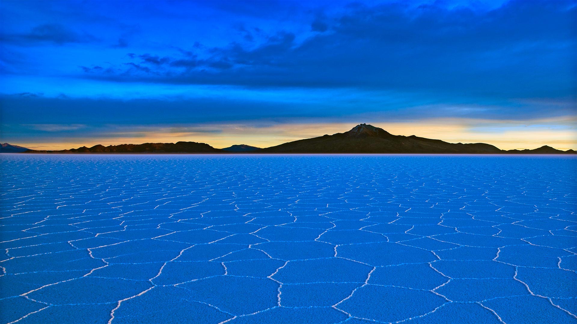
一小撮盐可不够 When just a pinch of salt won't do
玻利维亚乌尤尼盐沼
海拔超过2英里是自然界的一个异常现象,靠近安第斯山脉的顶峰,这是一个比许多国家都大的盐滩。玻利维亚的乌尤尼盐沼是世界上最大的盐沼,面积约4000平方英里。盐滩是一个古老湖泊的遗迹,它在很久以前就蒸发了,留下了厚厚的矿物外壳,这既是食用盐的来源,也是火烈鸟的重要繁殖地。但对于一个电池匮乏的世界来说,最大的财富可能就在地壳之下——一个富含锂的巨大卤水。
Salar de Uyuni in Bolivia
More than 2 miles above sea level is an anomaly of the natural world, near the crest of the Andes mountain range, a salt flat bigger than many countries. The Salar de Uyuni in Bolivia is the largest salt flat in the world at about 4,000 square miles. The salt flat is the remains of an ancient lake that evaporated long ago leaving behind a thick mineral crust that is both a source of edible salt and a critical breeding ground for, of all things, flamingos. But for a battery-hungry world, the greatest riches might lie below the crust—a vast brine rich in lithium.
佛罗伦萨大教堂, 意大利 The Cathedral of Florence, Italy (© Alexander Baert/Amazing Aerial Agency)
佛罗伦萨大教堂, 意大利 The Cathedral of Florence, Italy (© Alexander Baert/Amazing Aerial Agency)
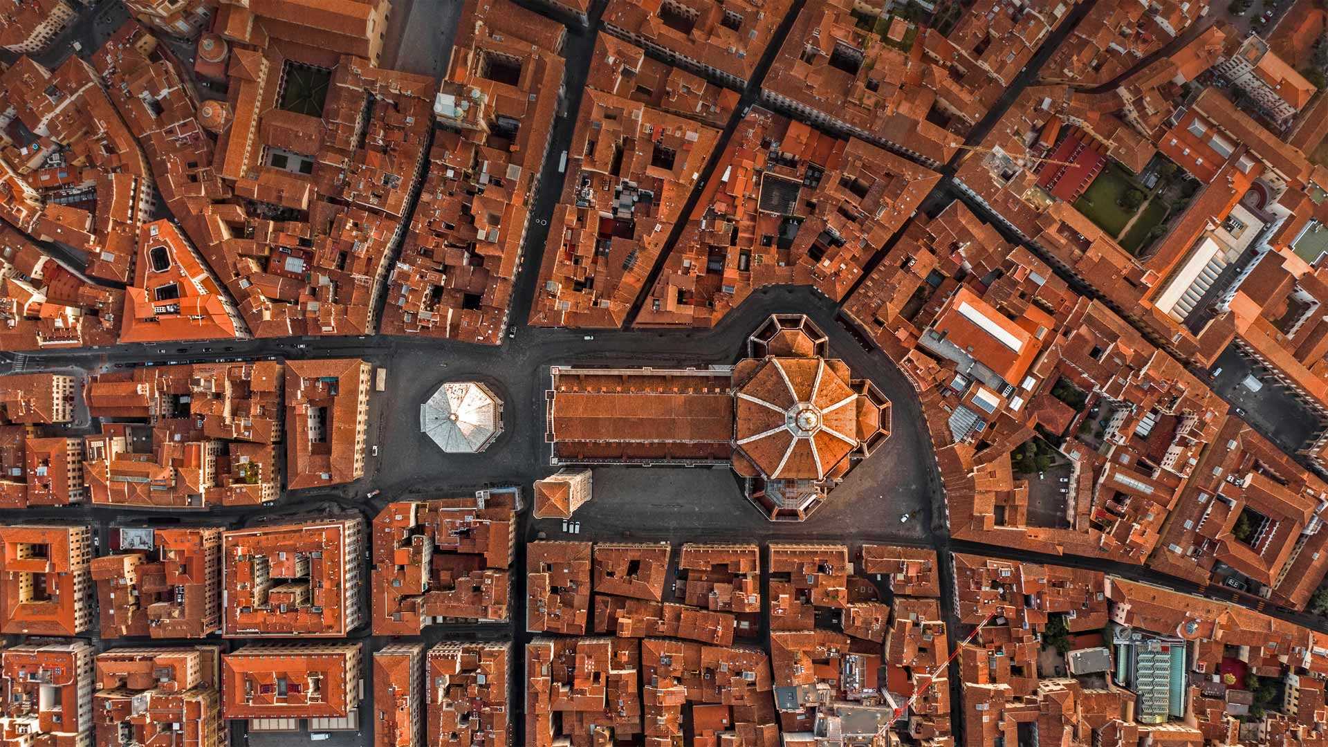
文艺复兴的诞生地 Birthplace of the Renaissance
意大利佛罗伦萨大教堂
佛罗伦萨被认为是文艺复兴的发源地,它帮助欧洲走出了中世纪,成为政治、金融、艺术和文化的中心。七个多世纪后,鸟瞰那个时代的奇迹,如圣玛利亚·德尔·菲奥雷大教堂(更简单地称为佛罗伦萨大教堂),简直是小菜一碟。在一座成就卓著的城市里,这座建筑群是一座辉煌的成就,除了大教堂及其宏伟的圆顶外,它还包括一座钟楼和一座白色屋顶的洗礼室。
The Cathedral of Florence, Italy
Considered the birthplace of the Renaissance, Florence helped lead Europe out of the Middle Ages as a center of politics, finance, art, and culture. Seven-odd centuries later, it's a snap to get aerial views of that era's marvels, like the Cathedral of Santa Maria del Fiore (known more simply as the Cathedral of Florence). A crowning achievement in a city of crowning achievements, the complex includes a campanile, or bell tower, and a white-roofed baptistery in addition to the cathedral with its grand dome.
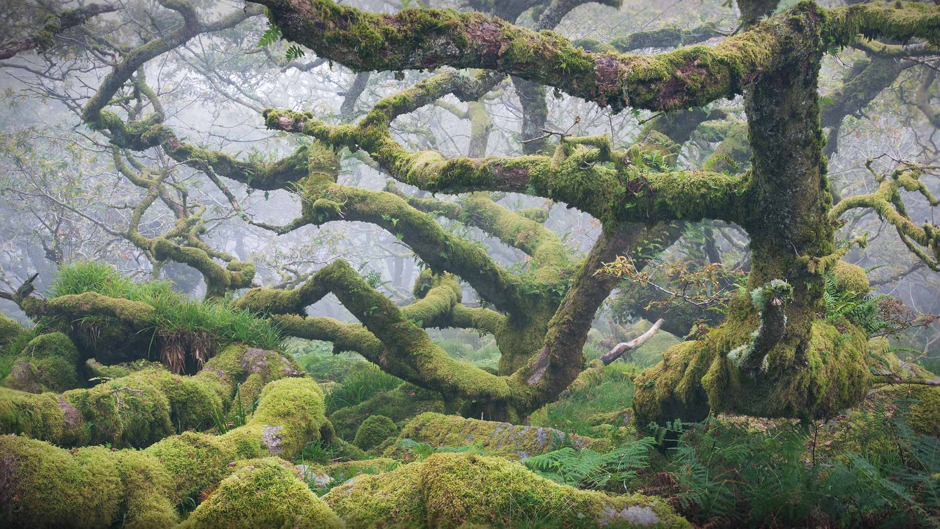
威斯特曼森林,达特穆尔国家公园,英格兰德文郡 (© Richard Garvey-Williams/Alamy)
贾斯珀国家公园纠结溪瀑布,阿尔伯塔省,加拿大 Tangle Creek Falls in Jasper National Park, Alberta, Canada (© Jeff Foott/Minden Pictures)
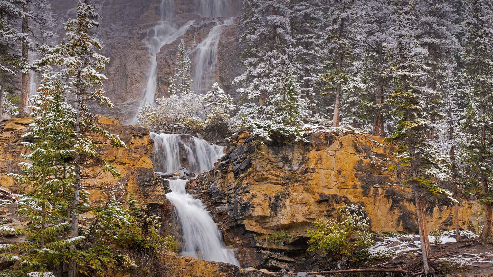
贾斯珀国家公园纠结溪瀑布,阿尔伯塔省,加拿大 Tangle Creek Falls in Jasper National Park, Alberta, Canada (© Jeff Foott/Minden Pictures)
落基山脉的径流 Rocky Mountain runoff
加拿大阿尔伯塔省贾斯珀国家公园
贾斯珀国家公园拥有众多令人惊叹的瀑布,但唐格尔溪瀑布的多层瀑布构成了必看的奇观。瀑布位于阿尔伯塔省93冰原公园道附近,很容易到达。坦格尔溪瀑布(Tangle Creek Falls)的水雾在高速公路上也能感受到。如果你想拍一些令人惊叹的照片,那么下了高速公路,走近瀑布,真正沉浸在瀑布的美景中可能是值得的。
Jasper National Park, Alberta, Canada
Jasper National Park boasts numerous breathtaking waterfalls, but the multi-tiered cascade of Tangle Creek Falls makes for a must-see spectacle. Located off the 93 Icefields Parkway in Alberta, the falls are easily accessed. Tangle Creek Falls' misty spray can be felt out on the highway itself. If you're looking to capture some breathtaking shots, it may be worth getting off the highway and going closer to the falls to truly soak in its beauty.