加勒比海的片脑纹珊瑚,开曼群岛 Symmetrical brain coral on a reef in the Caribbean Sea near Grand Cayman, Cayman Islands (© Alex Mustard/Minden Pictures)

加勒比海的片脑纹珊瑚,开曼群岛 Symmetrical brain coral on a reef in the Caribbean Sea near Grand Cayman, Cayman Islands (© Alex Mustard/Minden Pictures)
Brain coral
You needn't be a genius to guess how brain coral got its name. But you could just as easily call it 'maze coral' after its labyrinthine surface. Either way, this sea organism is an apt mascot for today's cerebral celebration: Puzzle Day!
From mazes to math problems to minute mysteries, you can find puzzles to tease just about every part of your brain, from the logical left hemisphere to the creative and crafty right. While medical science hasn't fully established that regular practice with puzzles benefits the brain, it's thought that solving puzzles helps concentration, pattern recognition, and memory. Or maybe they're just fun—but hey, that's excuse enough to riddle away the day on your favorite puzzles. Try starting off with today's homepage quiz.
脑珊瑚
你不必是个天才就能猜出brain coral是如何得名的。但你也可以简单地用迷宫般的表面来称呼它为“迷宫珊瑚”。不管怎样,这种海洋生物都是今天大脑庆祝活动的吉祥物:拼图日!
从迷宫到数学问题,再到微小的谜题,你可以找到谜题来挑逗你大脑的每一个部分,从逻辑的左半球到创造性和狡猾的右半球。虽然医学尚未完全证实经常练习拼图对大脑有益,但人们认为解决拼图有助于集中注意力、模式识别和记忆。或者也许它们只是好玩,但嘿,这足以让你在你最喜欢的谜题上度过这一天。试着从今天的主页测试开始。
梅兰加尔堡,印度焦特布尔 Mehrangarh Fort in Jodhpur, Rajasthan, India (© Jayakumar/Shutterstock)

梅兰加尔堡,印度焦特布尔 Mehrangarh Fort in Jodhpur, Rajasthan, India (© Jayakumar/Shutterstock)
India Republic Day
You might never guess that this ornate, skylit building, with an exterior covered in intricate carvings and artwork, was once a military base. Perched high on a hill above the city of Jodhpur, the colossal Mehrangarh Fort—aka the Citadel of the Sun—was built nearly five centuries before its home country became a democratic republic. Know which nation we're paying a birthday visit?
India's Republic Day commemorates January 26, 1950, when the constitution of India was adopted and the newly independent nation became a democratic republic. At the time of independence, the Republic of India had a population of 370 million, making the new nation the world's most populous democracy. It remains so today, with a population nearing 1.4 billion.
印度共和日
你可能永远也猜不到,这座华丽的天际建筑,外部覆盖着复杂的雕刻和艺术品,曾经是一个军事基地。坐落在焦特布尔市上方的一座小山上,巨大的梅兰加尔堡又名太阳城堡,在其祖国成为民主共和国之前的近五个世纪就建成了。知道我们要去哪个国家过生日吗?
印度共和日是为了纪念1950年1月26日,当时印度宪法获得通过,新独立的国家成为了一个民主共和国。独立时,印度共和国拥有3.7亿人口,使这个新国家成为世界上人口最多的民主国家。今天仍然如此,人口接近14亿。
安格尔西岛上的Tŵr Mawr 灯塔,英国威尔士 Tŵr Mawr lighthouse on Llanddwyn Island, Anglesey, Wales (© Joe Daniel Price/Getty Images)
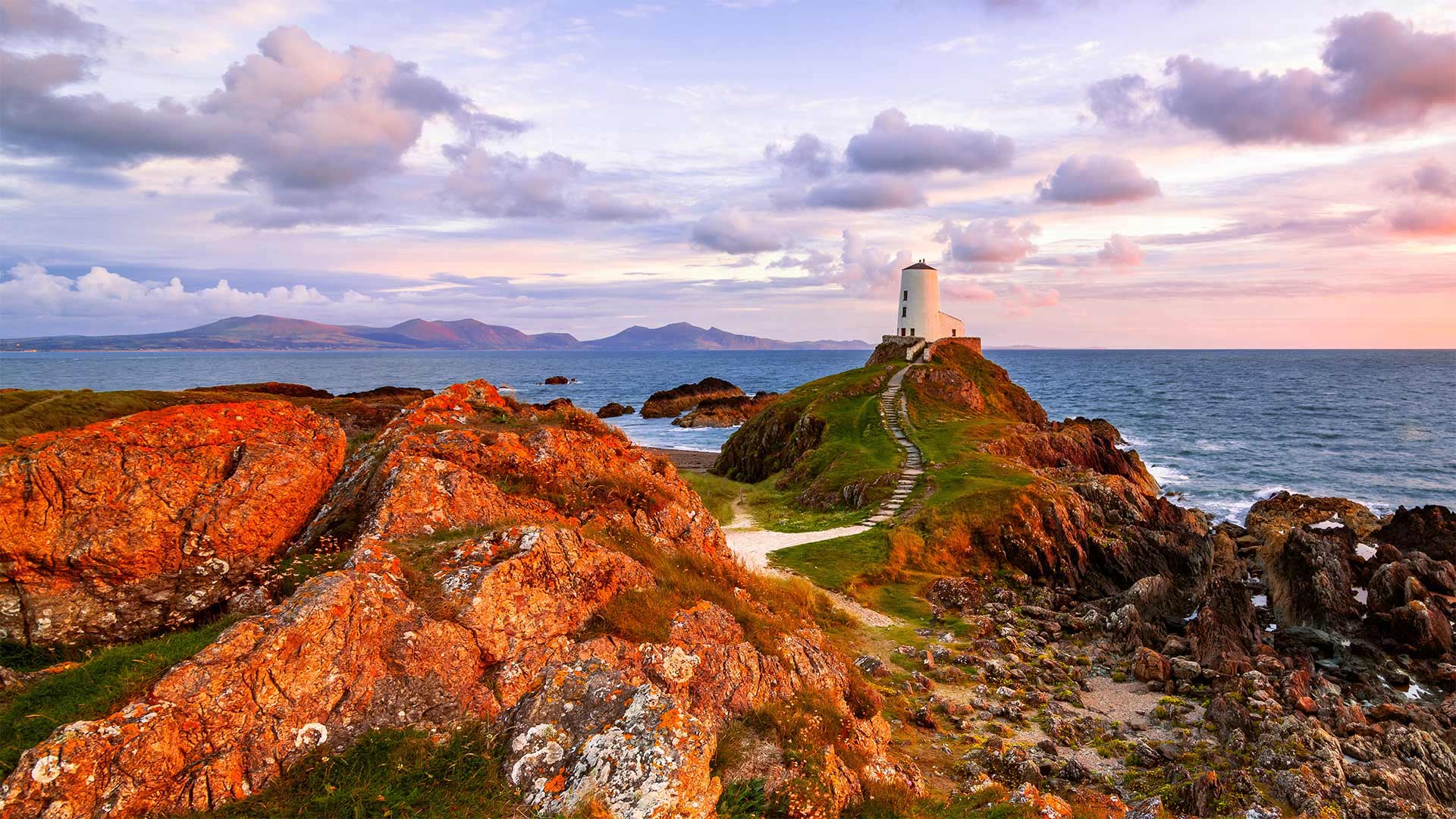
安格尔西岛上的Tŵr Mawr 灯塔,英国威尔士 Tŵr Mawr lighthouse on Llanddwyn Island, Anglesey, Wales (© Joe Daniel Price/Getty Images)
Saint Dwynwen's Day
Love is in the air on Llanddwyn Island at the southern tip of Anglesey, a much bigger island just off the north-west coast of Wales. Each year on January 25, Cupid aims his arrow toward the people of Wales who celebrate St. Dwynwen's Day–the Welsh version of St. Valentine's Day. St. Dwynwen is Wales' patron saint of lovers, although she was rather unlucky in that department after falling head over heels for a man she wasn't allowed to marry. The 5th-century princess' heartache led her to dedicate her life to God and pray for true lovers to have better fortune than her own. In return, Dwynwen became a nun and set up a convent here on Llanddwyn.
Despite its name, Llanddwyn Island is cut off from Anglesey's mainland only during very high tides. Since the 19th century, it has been home to Tŵr Mawr lighthouse (meaning 'great tower' in Welsh). The design of the lighthouse, seen in our photo today, is inspired by the area's many windmills. Just out of frame, you will find the remains of the church Dwynwen founded, along with a well named after her. It became a place of pilgrimage following her death. Legend has it that the well is home to sacred fish that can predict whether couples' relationships will succeed.
圣德温节
在安格西岛南端的兰德温岛上,爱在空中飘荡。安格西岛是威尔士西北海岸附近一个更大的岛屿。每年的1月25日,丘比特都会把箭射向威尔士人,他们庆祝圣德温节——威尔士版的圣瓦伦丁节。圣德温是威尔士的情人守护神,尽管她在那个部门很不幸,因为她被一个不允许嫁给的男人迷住了。这位五世纪公主的心痛促使她将自己的一生献给上帝,并祈祷真正的情人拥有比自己更好的财富。作为回报,德温温成为了一名修女,并在兰德温建立了一所修道院。
尽管兰德温岛名为兰德温岛,但只有在涨潮时,它才与安格西岛的大陆隔绝。自19世纪以来,它一直是Tŵr Mawr灯塔(威尔士语中的“大塔”意思)的所在地。我们今天的照片中看到的灯塔的设计灵感来自该地区的许多风车。刚走出画面,你会发现德温温创建的教堂的遗迹,以及一座以她的名字命名的教堂。她死后,这里成了朝圣之地。传说这口井是圣鱼的家园,可以预测夫妻关系是否会成功。
灯光璀璨的曼哈顿下城,美国纽约 Lower Manhattan in New York City (© New York On Air/Offset/Shutterstock)

灯光璀璨的曼哈顿下城,美国纽约 Lower Manhattan in New York City (© New York On Air/Offset/Shutterstock)
Manhattan
Ahhh, New York City. Well, Manhattan specifically, one of New York's five boroughs. This aerial view is of Lower Manhattan, what New Yorkers consider the heart of the city. That's New Jersey sparkling across the Hudson River in the distance. And those two bridges pictured on the left are the Brooklyn Bridge (above) and the Manhattan Bridge (below), linking the island of Manhattan to the borough of Brooklyn.
Anytime is the right time to take in the nighttime views of New York City from high above, but the cityscape in January might be especially beguiling. For one thing, you won't have to fight crowds to stand at the windows to view the dazzling lights. May we recommend the observation decks of the Empire State Building, Top of the Rock, and the One World Trade Center Observatory? Happy gazing.
曼哈顿
啊,纽约市。特别是曼哈顿,纽约五个行政区之一。鸟瞰鸟瞰曼哈顿,纽约人认为这座城市的中心。那是新泽西州,在远处的哈德逊河上闪闪发光。左边的两座桥分别是布鲁克林大桥(上图)和曼哈顿大桥(下图),它们将曼哈顿岛与布鲁克林区连接起来。
任何时候都是从高处欣赏纽约市夜景的最佳时机,但一月份的城市景色可能特别迷人。首先,你不必为了站在窗户前观看耀眼的灯光而与人群搏斗。我们可以推荐帝国大厦的观景台、岩石顶观景台和世界贸易中心观景台吗?快乐的凝视。
海岸旁的二见浦夫妇岩,日本三重县 Meoto Iwa (Wedded Rocks) off the coast of Ise, Mie Prefecture, Honshu, Japan (© Marco Gaiotti/plainpicture)
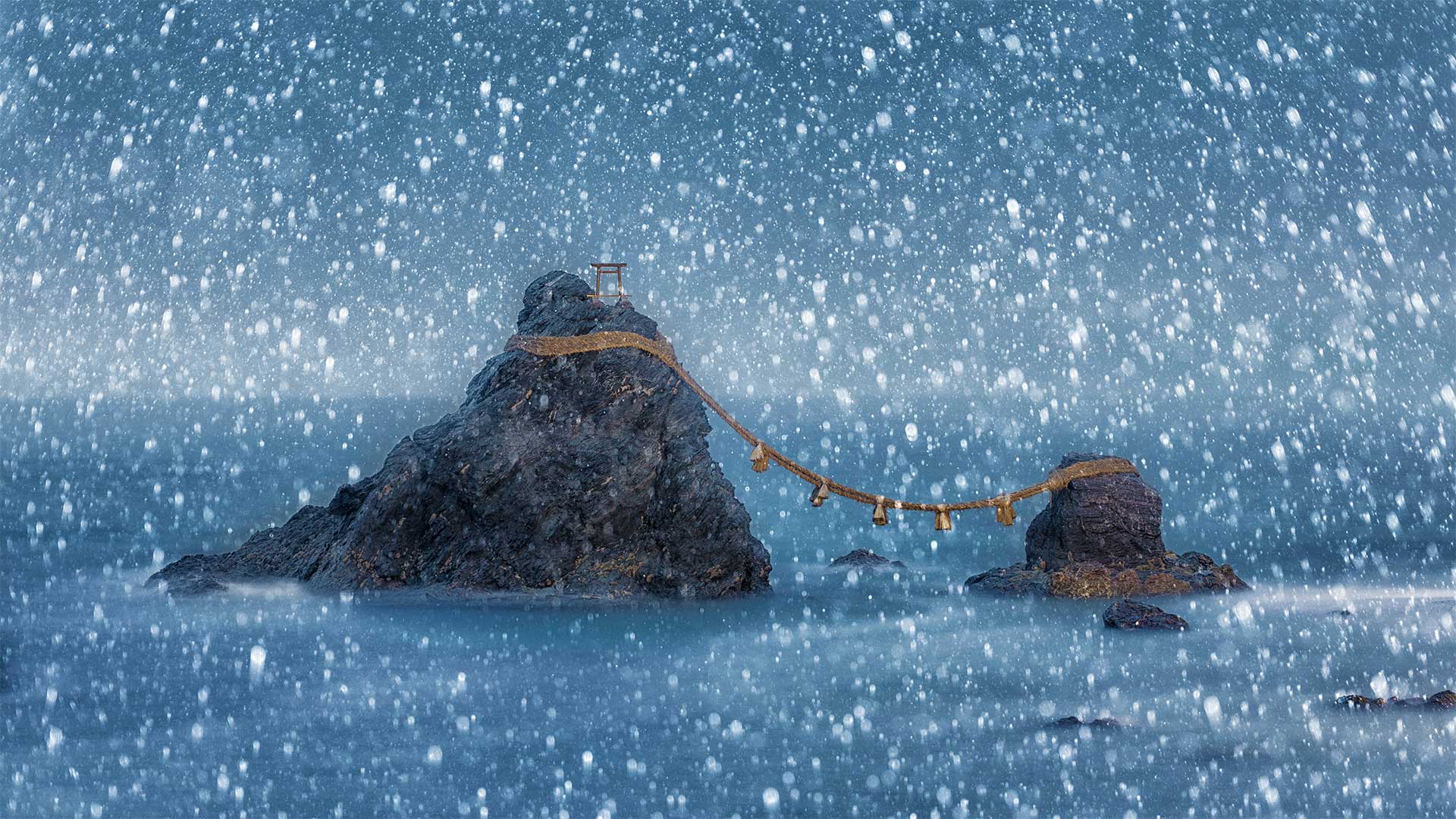
海岸旁的二见浦夫妇岩,日本三重县 Meoto Iwa (Wedded Rocks) off the coast of Ise, Mie Prefecture, Honshu, Japan (© Marco Gaiotti/plainpicture)
Wedded Rocks, Japan
Just off the shore of the city of Ise, in the southern-central region of Japan's main island, Honshu, two rocks represent a sacred union between a divine couple. Known collectively as Meoto Iwa (Wedded Rocks), these sea stacks represent Izanagi and Izanami, the married brother-and-sister deities who created the islands of Japan and its gods in Japanese mythology. The large rock on the left is said to be the husband, Izanagi–at its peak is a small torii, a symbolic gateway marking the entrance to a Shinto shrine. The smaller rock represents his wife, Izanami.
The smitten sea stacks are joined together in matrimony by a thick rope braided of rice straw called 'shimenawa,' which is used as a symbol of purity and protection in the Shinto religion. The sacred rope is replaced in a special ceremony, held three times each year during the months of May, September, and December. The best time to see the rocks is at dawn during summer or twilight in winter, when the sun and moon, respectively, rise between them. If the weather is clear and the gods are on your side, you might even catch a glimpse of Mount Fuji in the distance. But we think it's just as beguiling with heavy snowflakes gently falling all around.
婚礼岩石,日本
离日本本州岛中南部的伊瑟市不远,两块岩石代表着一对神圣的夫妻之间的神圣结合。这些海堆被统称为Meoto Iwa(Wedded Rocks),它们代表了在日本神话中创造了日本岛屿及其诸神的已婚兄弟姐妹神Izanagi和Izanami。左边的大石头据说是丈夫Izanagi——山顶上是一个小牌坊,一个象征性的大门,标志着神社的入口。较小的岩石代表他的妻子伊扎纳米。
被击倒的海垛在婚礼上由一根由稻草编织而成的粗绳连接在一起,称为“shimenawa”,在神道教中被用作纯洁和保护的象征。在每年5月、9月和12月举行的三次特殊仪式中,更换神圣绳索。观赏这些岩石的最佳时间是夏季的黎明或冬季的黄昏,此时太阳和月亮分别从它们之间升起。如果天气晴朗,众神在你身边,你甚至可以瞥见远处的富士山。但我们认为,这和四周轻轻飘落的厚厚的雪花一样迷人。
蔚蓝海域中的马提尼克岛,加勒比海 Martinique, Lesser Antilles, Caribbean Sea (© Airpano LLC/Amazing Aerial Agency)
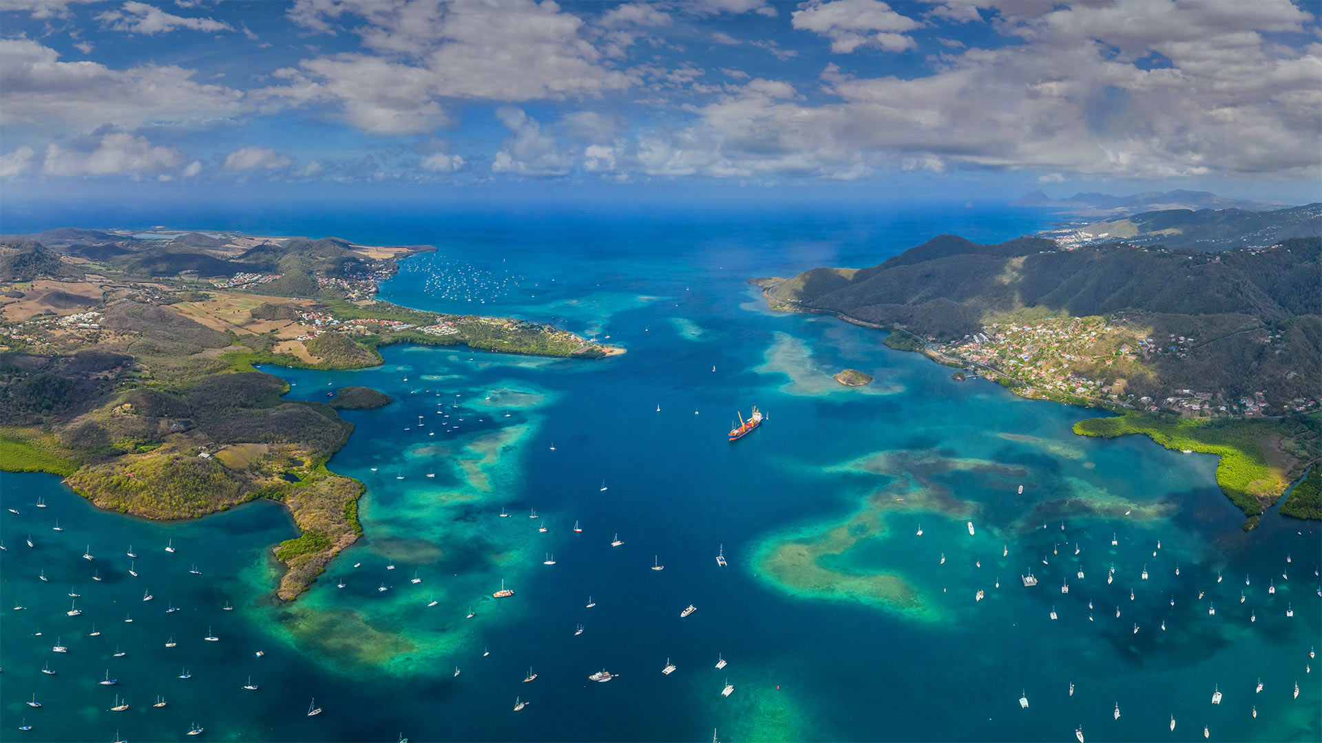
蔚蓝海域中的马提尼克岛,加勒比海 Martinique, Lesser Antilles, Caribbean Sea (© Airpano LLC/Amazing Aerial Agency)
Martinique
Welcome to France—but don't expect your picture taken at the Eiffel Tower today. Folks from this island destination may speak French and spend Euros, but we're more than 4,000 miles from Paris.
The isle of Martinique in the Caribbean is one of many overseas territories of France. That means not only do locals enjoy the same French citizenship as anyone in European France, but French people from the mainland side can visit these warm blue shores all year without setting foot on foreign soil.
马提尼克岛
欢迎来到法国,但不要期待你今天在埃菲尔铁塔拍照。来自这个岛屿目的地的人们可能会说法语并花费欧元,但我们离巴黎有4000多英里。
加勒比地区的马提尼克岛是法国众多海外领土之一。这意味着当地人不仅享有与欧洲法国任何人相同的法国公民身份,而且来自大陆的法国人全年都可以访问这些温暖的蓝色海岸,而不必踏上异国的土地。
克卢恩国家公园保护区的山脉和冰川,加拿大育空地区 Saint Elias Mountains and Kaskawulsh Glacier in Kluane National Park and Reserve, Yukon, Canada (© Design Pics Inc/Alamy)

克卢恩国家公园保护区的山脉和冰川,加拿大育空地区 Saint Elias Mountains and Kaskawulsh Glacier in Kluane National Park and Reserve, Yukon, Canada (© Design Pics Inc/Alamy)
Kluane National Park
What looks here like an ice road for 50-foot-tall truckers is really Kaskawulsh Glacier in Canada's Kluane National Park. This corner of the Yukon is home to the largest ice field on Earth outside of the poles, with the slow, steady flow of more than 2,000 glaciers continually carving these vast canyons amid the peaks.
Speaking of peaks, glance up and you'll see the Yukon is also paradise for mountain lovers. And Kluane is its pinnacle, literally: Located within the park is Mount Logan, the highest mountain in Canada (and second-highest on the continent after Alaska's Denali).
库隆尼国家公园
对于50英尺高的卡车司机来说,这里看起来像是一条冰路,实际上是加拿大克鲁恩国家公园中的卡斯卡沃尔什冰川。育空地区的这个角落是地球上除极地以外最大的冰原的所在地,2000多条缓慢而稳定的冰川不断地在山峰之间雕刻着这些巨大的峡谷。
说到山峰,抬头一看,你会发现育空地区也是高山爱好者的天堂。Kluane是它的巅峰,字面意思是:位于公园内的是加拿大最高的山脉洛根山(仅次于阿拉斯加的德纳利山,是该大陆第二高的山)。
博格豪森镇和萨尔察赫河,德国巴伐利亚州 Burghausen town and Salzach river, Bavaria, Germany (© Harald Nachtmann/Moment/Getty Images)
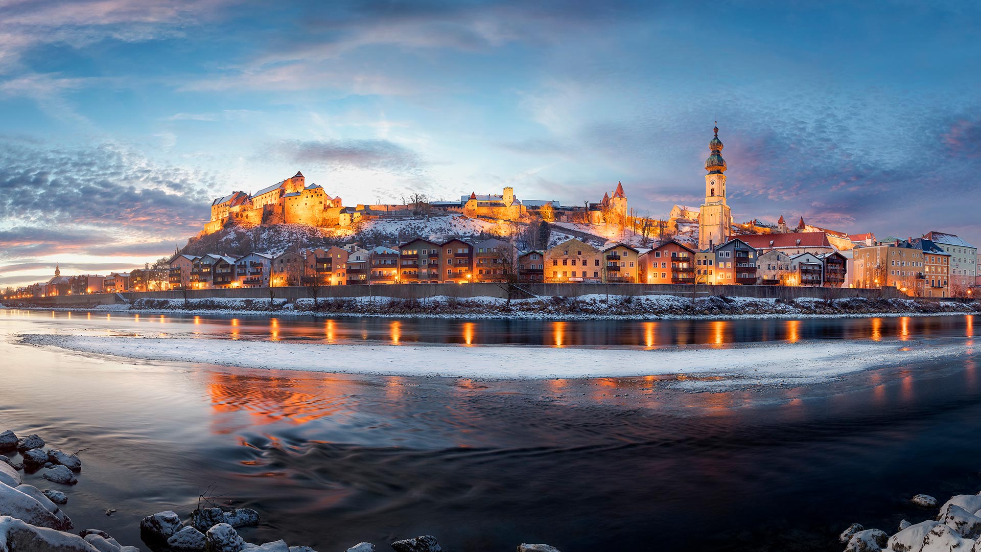
博格豪森镇和萨尔察赫河,德国巴伐利亚州 Burghausen town and Salzach river, Bavaria, Germany (© Harald Nachtmann/Moment/Getty Images)
Burghausen town and Salzach river, Bavaria, Germany
The town of Borghausen is located on the banks of the Salchach, a large river in the Alps, which at 225 km. The name "castle" is rarely as specific as it is in upper Bavarian town, cause Borghausen boasts the world's longest castle complex at 1,051 meters.
The impressive defensive structure sits on a ridge above the old town, with a total of six courtyards. The oldest part dates back to the Middle Ages, with the first documentary mentioning around 1025. The main castle represents the oldest part of it, which can be seen clearly on the left side in the picture.
德国巴伐利亚州Burghausen镇和Salzach河
Borghausen镇位于阿尔卑斯山脉的一条大河Salchach河岸上,全长225公里。“城堡”这个名字很少像在上巴伐利亚镇那样具体,因为博格豪森拥有世界上最长的城堡建筑群,高1051米。
令人印象深刻的防御结构坐落在老城上方的山脊上,共有六个庭院。最古老的部分可以追溯到中世纪,第一部纪录片提到1025年左右。主城堡代表了它最古老的部分,在图片的左侧可以清楚地看到。
莱达尔湖, 英格兰坎布里亚郡湖区 Rydal Water in the Lake District, Cumbria, England (© Tranquillian1/iStock/Getty Images Plus)
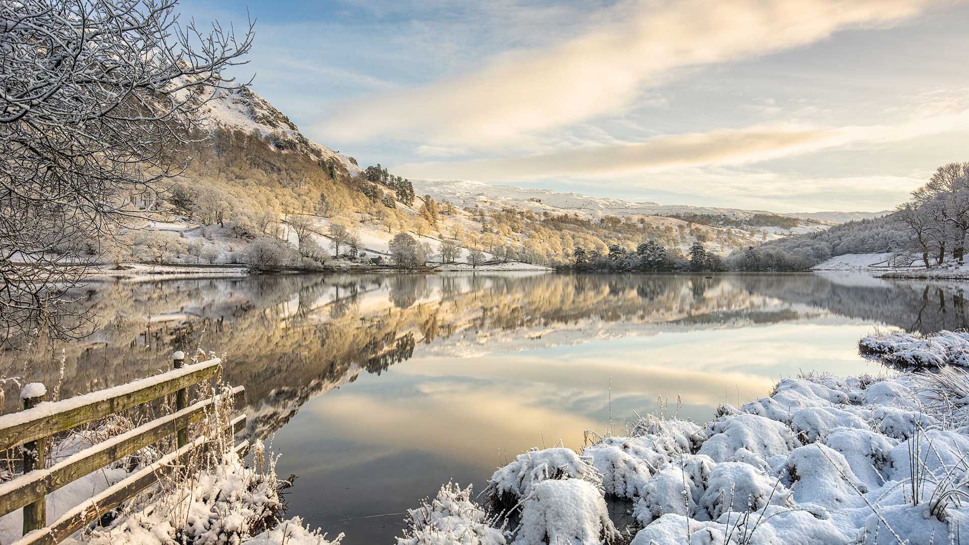
莱达尔湖, 英格兰坎布里亚郡湖区 Rydal Water in the Lake District, Cumbria, England (© Tranquillian1/iStock/Getty Images Plus)
Rydal Water in the Lake District, Cumbria, England
Reflecting winter skies and frozen fells in our homepage image is Rydal Water, one of the smallest but prettiest lakes in the Lake District. Rydal Water is one of the two lakes most associated with William Wordsworth, one of England’s greatest poets. (The other is neighbouring Grasmere, to which Rydal is connected by the River Rothay.) Wordsworth lived around these bodies of water, first at Dove Cottage and later Rydal Mount, between 1799 and 1850, writing some of his best-known works and hosting leading lights of the Romantic movement, including his friend, Samuel Taylor Coleridge. To the western edge of the lake is Wordsworth’s Seat, a rocky outcrop said to be the writer’s favourite spot.
Rydal Water is in a glacial valley, one of 13 valleys in the Lake District. Partly owned by the National Trust, it sits at the foot of Loughrigg Fell and has been known to freeze over on winter days like this one. You can walk around Rydal Water and take in Wordsworth’s former homes as well as passing by Rydal Cave in the hill above the lake. Surrounded by woodland, pasture and craggy fells, with several historic properties and beautifully designed landscapes, this is an inspiring place for aspiring poets, whatever the season.
英格兰坎布里亚湖区的赖德尔水
赖达尔湖是湖区最小但最美丽的湖泊之一,它反映了我们主页图像中冬季的天空和冰冻的森林。莱德尔湖是与英国最伟大的诗人之一威廉·华兹华斯联系最为密切的两个湖泊之一。(另一个是邻近的格拉斯米尔,莱德尔河与之相连。)1799年至1850年间,华兹华斯生活在这些水域周围,先是在多夫小屋,后是莱德尔山,他写了一些最著名的作品,并主持了浪漫主义运动的主要活动,包括他的朋友塞缪尔·泰勒·柯勒律治。湖的西边是华兹华斯的所在地,据说这是作家最喜欢的地方。
莱德尔河位于一个冰川峡谷中,是湖区13个山谷之一。部分归国家信托基金所有,坐落在Loughrigg Fall脚下,在像这样的冬天会结冰。你可以在莱达尔水边散步,参观华兹华斯的故居,也可以经过湖上小山上的莱达尔洞穴。这里被林地、牧场和崎岖的小林所环绕,有几处历史古迹和设计精美的景观,无论什么季节,这都是一个让有抱负的诗人感到振奋的地方。
农场上晾晒的红辣椒,孟加拉国博格拉县 Sorting chili peppers at a farm in Bogra, Bangladesh (© Amazing Aerial Agency/Offset/Shutterstock)

农场上晾晒的红辣椒,孟加拉国博格拉县 Sorting chili peppers at a farm in Bogra, Bangladesh (© Amazing Aerial Agency/Offset/Shutterstock)
Hot and Spicy Food Day
The super-spicy curries of Bangladeshi cuisine start out here in the chili fields, where workers harvest and sort red chili peppers by hand. Once picked, the peppers are sun-dried and used whole or ground to powder. The chilis not only add a flavorful kick to foods but help kill bacteria as well. Plus, hot foods actually help diners cool down: One natural reaction to capsaicin, the active chemical in chilis, is sweating, which can help chill the skin amid tropical heat.
We're visiting this chili harvest in honor of International Hot and Spicy Food Day. Whether you're already crazy for chilis or just looking to broaden your spicy-food horizons, today's the day to try that level 5 Thai curry or a burrito with habanero salsa—or if you're truly capsaicin-averse, turn up the heat with a Spice Girls or Red Hot Chili Peppers playlist.
辛辣食物日
孟加拉国菜的超辣咖喱起源于辣椒田,工人们在那里手工收割和分类红辣椒。采摘后,将辣椒晒干,整粒或磨成粉末。辣椒不仅能给食物增添香味,还能杀灭细菌。此外,热的食物实际上有助于食客降温:辣椒中的活性化学物质辣椒素的一种自然反应是出汗,这有助于在热带炎热中使皮肤降温。
为了纪念国际辛辣食物日,我们正在参观这个辣椒收获节。无论你是已经对辣椒着迷,还是只是想拓宽你对辛辣食物的视野,今天都可以尝试5级泰式咖喱或哈巴内罗沙沙卷饼,或者如果你真的不喜欢辣椒素,那就用辣妹或红辣椒播放列表来增加热度。