云层中的纽约市天际线 New York City skyline in fog (© Orbon Alija/Getty Images)
云层中的纽约市天际线 New York City skyline in fog (© Orbon Alija/Getty Images)
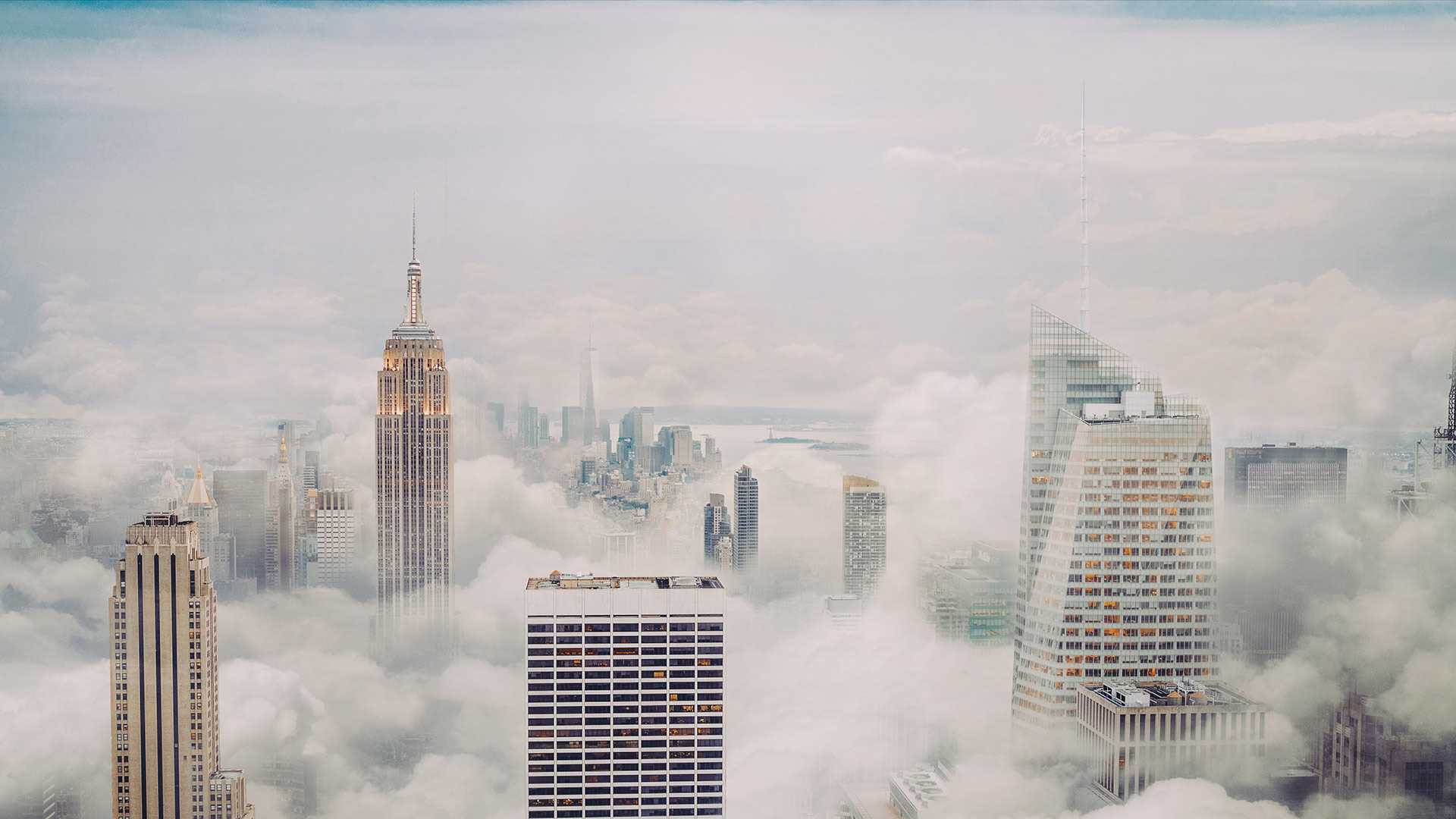
云雾缭绕的纽约市 The Big Apple with a foggy topping
纽约市的天际线
即使笼罩着朦胧雾气,纽约市的天际线也能一眼就被认出。美国最高的建筑中有八座都位于纽约曼哈顿区。帝国大厦也许是纽约最著名的大楼,曾连续36年都是世界上最高的建筑。而现在,世贸中心的一号楼因其高耸的塔尖成为了美国目前最高的建筑。纽约市的许多摩天大楼都是装饰艺术风格,如《周六夜现场》的录制地洛克菲勒广场30号大厦,以及装饰着镀铬合金老鹰及点缀的克莱斯勒大厦。来到纽约,你会忍不住不停抬头去仰望这些百年来的摩登奇迹。
New York City skyline
New York City's skyline is instantly recognizable, even when half-covered in fog. Eight of the United States' 10 tallest buildings reside there, all in the borough of Manhattan. One of New York City's most famous landmarks, the Empire State Building, was the world's tallest building for 41 years.
When it was completed in 1931, it towered over New York City's skyline, the first building in the world to be more than 100 stories tall. But in the decades since, it has been joined by scores of other skyscrapers and is now the Big Apple's seventh-tallest building. While it may have been overtaken by some of its younger neighbors, the Empire State Building remains one of the most iconic features of New York's skyline, if you can see it through the fog.
安沙波利哥沙漠州立公园的野花,加利福尼亚州,美国 Wildflowers in Anza-Borrego Desert State Park, California (© Ron and Patty Thomas/Getty Images)
安沙波利哥沙漠州立公园的野花,加利福尼亚州,美国 Wildflowers in Anza-Borrego Desert State Park, California (© Ron and Patty Thomas/Getty Images)
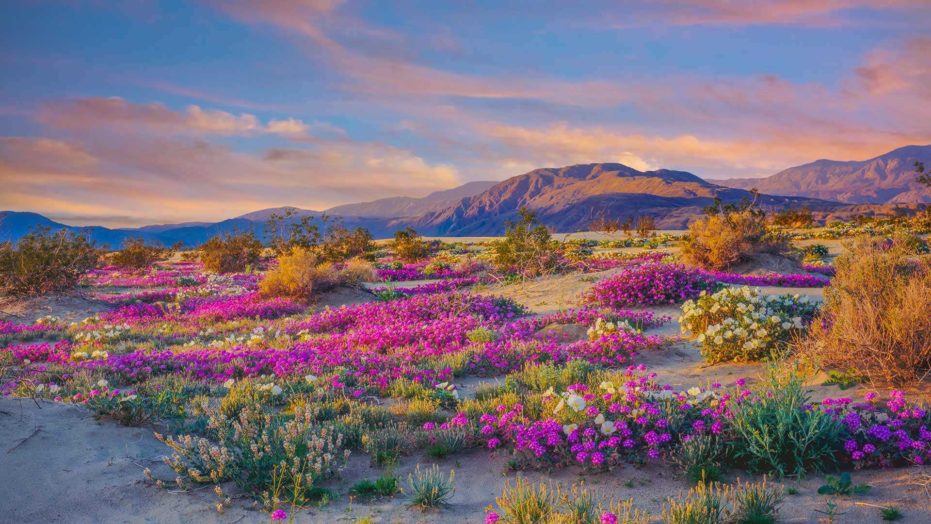
大自然最为色彩鲜艳的一面 Nature at its colorful best
安沙波利哥沙漠州立公园,加利福尼亚州,美国
欢迎来到美国加州最大的沙漠州立公园——安沙波利哥。这个公园以烂漫春花和自然奇观而闻名。初夏是游览的最佳时节,漫山遍野都是各种野花、植物和仙人掌。这些野花为原本贫瘠的沙漠景观增添了色彩,吸引大批游客的到来。尽管你可能会想摘一些回家,但野花受到加州法律的保护,再说美景也不应私藏,而应大家共赏。
Anza-Borrego Desert State Park, California
Welcome to the largest state park in the golden state of California, Anza-Borrego. Located about 100 miles northeast of San Diego, the park is well known for its spectacular springtime wildflowers, stunning landscapes, and natural marvels. Spring and early summer are the best times to visit. That's when you'll find a myriad of magnificent, blooming species of flowers, including dune primrose, desert sunflowers, and desert sand verbena. These hardy wildflowers can survive in extreme heat and with little water–perfect for California's driest state park, in which some areas get just 2 inches of rain a year.
Heavier rains than usual brought a rare 'winter bloom' of wildflowers to Anza-Borrego earlier this year. And record-breaking rainstorms have continued, ensuring an excellent spring display. The wildflowers draw large crowds of tourists to the area. Though you might be tempted to take some home, the wildflowers are protected by state law and should be left for everyone to enjoy.
鲍威尔湖,美国 Lake Powell on the Colorado River (© Peter Schaefer/Alamy)
鲍威尔湖,美国 Lake Powell on the Colorado River (© Peter Schaefer/Alamy)
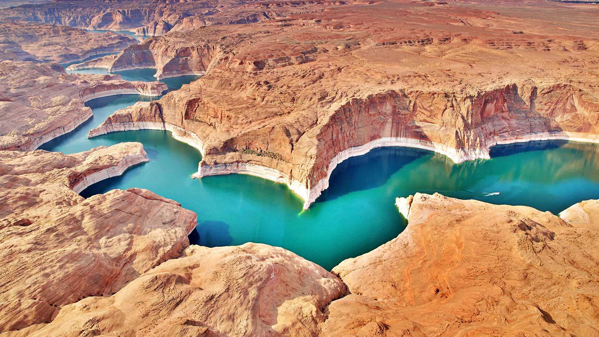
蜿蜒曲折的人工湖泊,鲍威尔湖 Man-made, meandering Lake Powell
世界水日
鲍威尔湖是科罗拉多河上的一座人工水库,跨越犹他州和内华达州边境。19世纪60年代美国修建格伦峡谷大坝后形成了这个水库。大坝利用水力发电,但同时也因为湖面加大了水体的表面积,从而更多的水被蒸发,造成了水资源流失。2000年干旱来临时,鲍威尔湖的水位开始直线下降,到2005年时,鲍威尔湖的储水量几乎仅为1999年时的一半。人类对水资源是极度依赖的,因此联合国在1993年设立了世界水日,旨在通过教育和公益活动在政府和普通人群层面上建立起更好的用水措施。全球人口正在增长,我们每个人都必须为保护水资源和清洁水资源出一份力。
World Water Day
Lake Powell is a man-made reservoir on the Colorado River, stretching across the Utah and Nevada border. It was formed in the 1960s after the US built the Glen Canyon Dam. Though the dam creates power through hydroelectricity, it also causes water loss due to evaporation from the broader surface area of the lake. When the drought took hold around 2000, the lake's water levels began to plummet, and in 2005 it lost nearly half of its volume compared to 1999. It's important to consider our dependence on freshwater, which is why the United Nations created World Water Day in 1993. Through education and activism, they aim to create better water practices on governmental and individual levels. As our global population increases, it's crucial that we all do our part to conserve our freshwater and keep it clean.
马萨诸塞州格洛斯特的沼泽地 Marshland, Gloucester, Massachusetts (© Thomas H. Mitchell/Getty Images)
马萨诸塞州格洛斯特的沼泽地 Marshland, Gloucester, Massachusetts (© Thomas H. Mitchell/Getty Images)
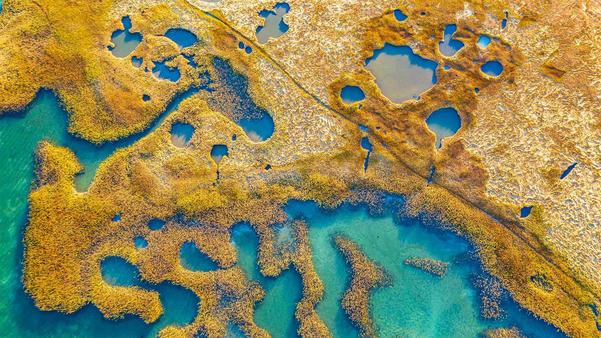
像一张油画 Like paint on a canvas
沼泽地,格洛斯特,美国马萨诸塞州
在新英格兰灿烂阳光的照耀下,这片盐沼地里的耐盐植物和海水形成了色彩鲜明的对比。盐沼是水生食物链中重要的一环,同时也是孕育野生动植物的温床。
这片沼泽位于美国最古老的海港——马萨诸塞州的格洛斯特。这个宁静的夏季度假胜地很受欢迎,游客们可以在这里享受新鲜捕获的美味海鲜、迷人的海滩、沼泽、划船、参观博物馆。尽管格洛斯特有种让人昏昏欲睡的小镇气息,但它距离繁华的波士顿只有45分钟车程。
Marshland, Gloucester, MA
Lit by bright New England sunshine, this salt marsh shows a strong contrast of color between the sea water and the salt-tolerant grass that grows there. Salt marshes serve as a major contributor to the aquatic food web and a nursery for wildlife, both terrestrial and aquatic.
These marshes are located in Gloucester, Massachusetts, America's oldest seaport. Tourists frequenting this tranquil summer vacation spot enjoy freshly caught delicious seafood, stunning beaches, marshes, museums, and boating. Though Gloucester may have a sleepy, small-town feel, it's only 45 minutes away from the bustling state capital city of Boston. Oh, and it's pronounced 'glosster' unless you're from Massachusetts—then it's 'glosstah.'
威美亚峡谷和怀波奥瀑布上空的彩虹, 考艾岛, 夏威夷, 美国 Rainbow over Waimea Canyon and Waipo'o Falls, Kauai, Hawaii (© Beverley Van Praagh/Getty Images)
威美亚峡谷和怀波奥瀑布上空的彩虹, 考艾岛, 夏威夷, 美国 Rainbow over Waimea Canyon and Waipo'o Falls, Kauai, Hawaii (© Beverley Van Praagh/Getty Images)
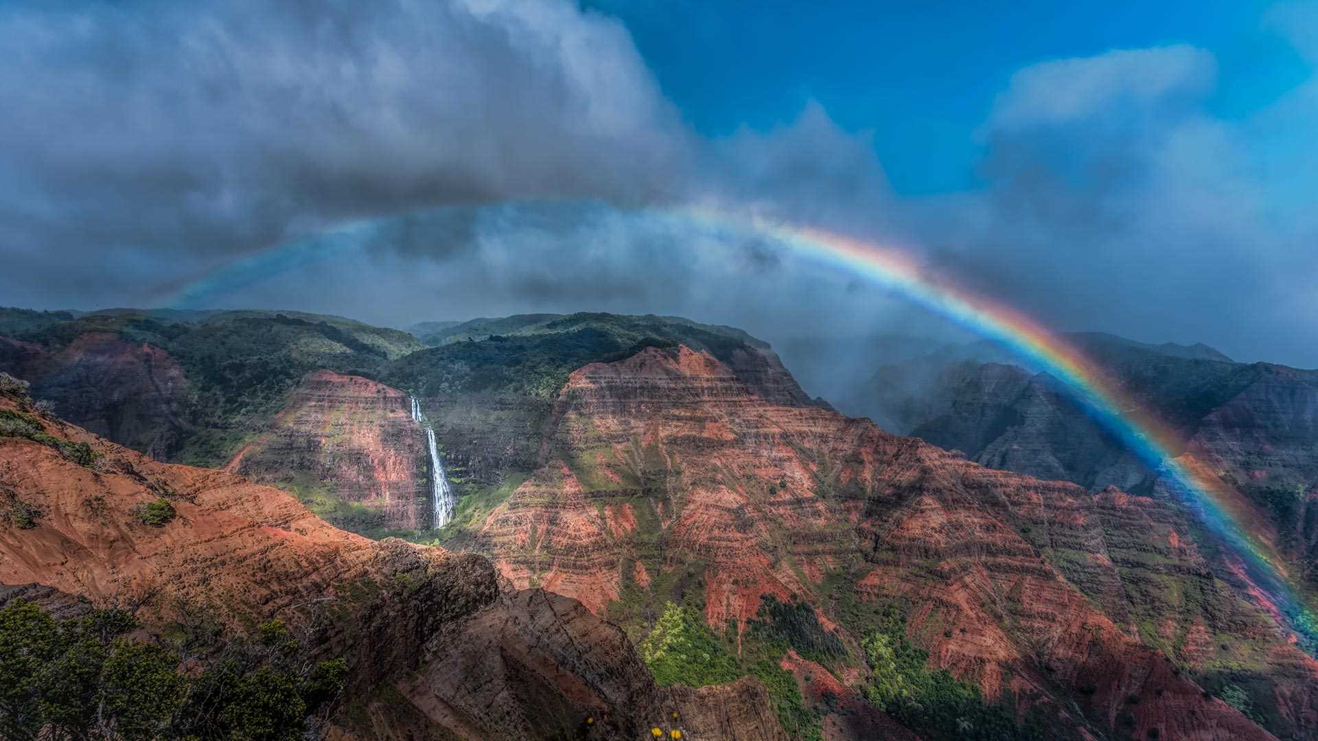
雨后见彩虹 A rainbow that's worth the rainfall
威美亚峡谷上空的彩虹,夏威夷
威美亚峡谷被誉为“太平洋大峡谷”,是风景如画的怀波奥瀑布所在地。瀑布和峡谷河流的源头来自地球上降雨量最多的地方之一怀厄莱阿莱峰。大约400万年前,考艾岛火山坍塌了一部分,形成了一个洼地,随着威美亚河流的不断侵蚀,洼地逐渐变成了如今的威美亚峡谷。考艾岛地形多变,风景各不相同,如果你想探寻考艾岛的多样性,可以离开海滩,沿着蜿蜒的550高速公路进入山区,在到达怀波奥瀑布观景台之前,你会在沿途收获海岸和峡谷的壮丽景色。
Waimea Canyon and Waipo'o Falls, Kauai, Hawaii
Waimea Canyon, sometimes referred to as the Grand Canyon of the Pacific, is home to the picturesque Waipo'o Falls. The water that flows through the falls and canyon descends from Mount Wai'ale'ale, one of the rainiest places on Earth. Around 4 million years ago, a portion of the volcanic Kaua'i collapsed, creating a depression that the Waimea River has further eroded into today's canyon. If you want to see the true variety of Kauai, leave the beach behind and take winding State Route 550 into the mountains. Along the way you will see stunning views of the shore and the canyon before arriving at the lookout for Waipo'o Falls.
布莱斯峡谷国家公园的石林,犹他州,美国 Hoodoos at Bryce Canyon National Park, Utah (© Piriya Photography/Getty Images)
布莱斯峡谷国家公园的石林,犹他州,美国 (© Piriya Photography/Getty Images)
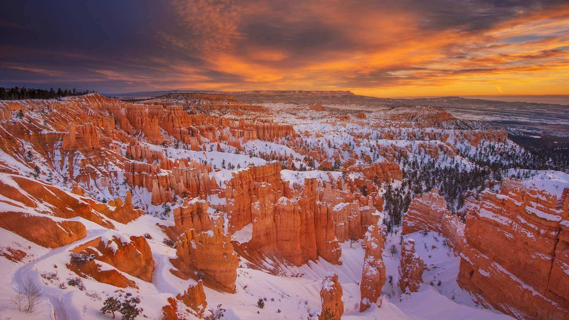
冬天的布莱斯峡谷石林 Bryce Canyon hoodoos in winter
布莱斯峡谷国家公园
当太阳在布莱斯峡谷升起时,白雪皑皑的橙红色岩石闪闪发光。这些修长高耸的岩石被称为石林,而布莱斯峡谷国家公园正是因为拥有地球上密度最高的石林而闻名。这些石林的下层是松软的沉积岩,上面则覆盖着一层更为坚硬的石盖。犹他州冬天的冰霜会侵蚀石盖,最终暴露出底下更易被侵蚀的岩石。值得庆幸的是,这些石林现在还屹立不倒,让我们可以在公园成立100周年之时欣赏大自然的鬼斧神工。
Bryce Canyon National Park turns 100
As the sun rises on Bryce Canyon, its snowcapped red-orange rock formations start to glow. These slender, towering rocks are called hoodoos, and Bryce Canyon National Park is remarkable for having the highest concentration of hoodoos anywhere on Earth. The hoodoos here have a soft base of sedimentary rock with a cap of more solid stone on top. The snow and frost of the Utah winter will eventually erode the support of the cap, causing it to fall and expose the remaining rock to easier erosion. Thankfully these formations are standing now, allowing us to take in their natural majesty as the park celebrates its 100th anniversary.
毛伊岛附近的座头鲸,美国夏威夷 Humpback whales, Maui, Hawaii (© Flip Nicklin/Minden Pictures)
毛伊岛附近的座头鲸,美国夏威夷 Humpback whales, Maui, Hawaii (© Flip Nicklin/Minden Pictures)
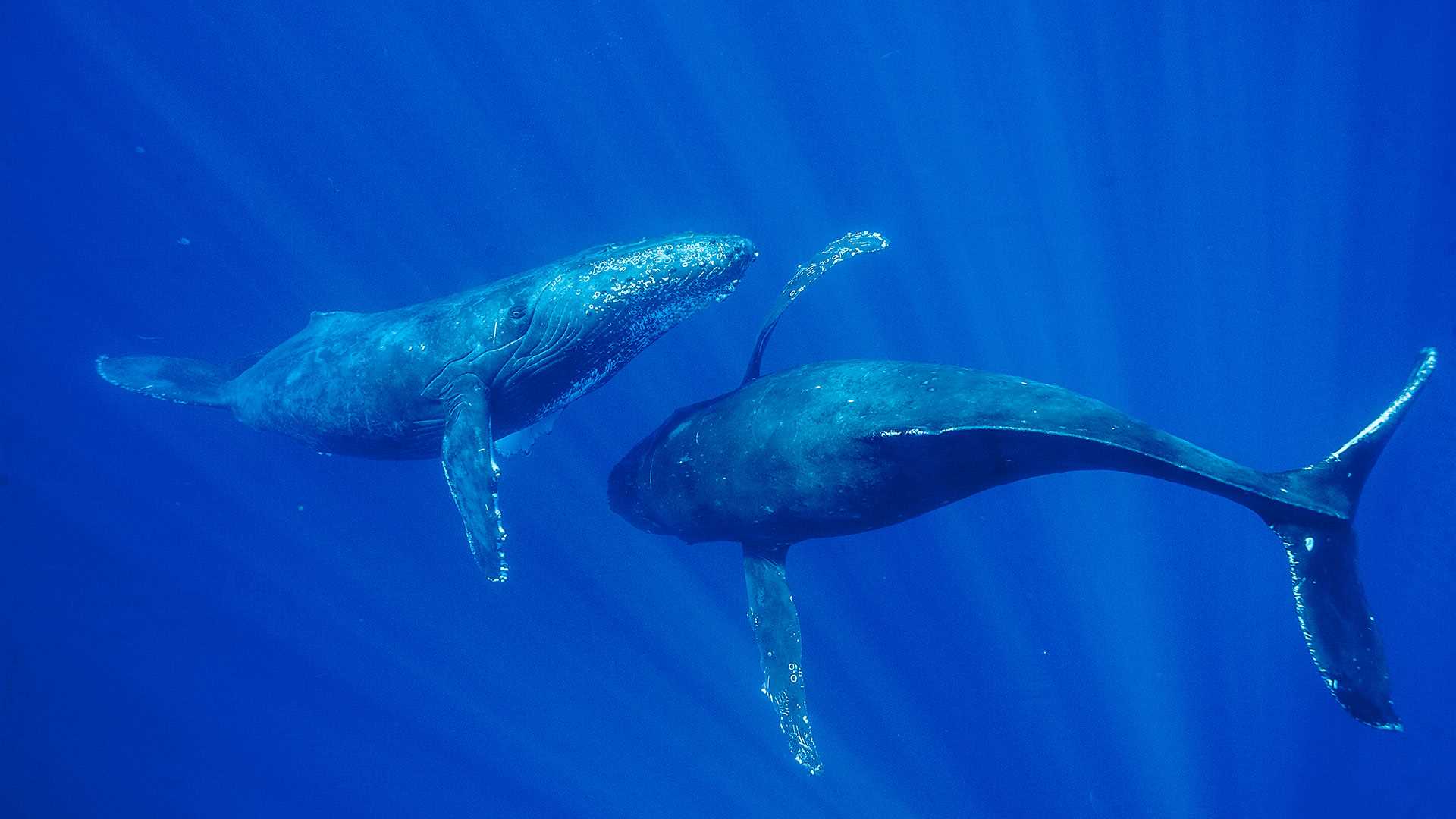
海洋之王 King of the ocean
毛伊岛鲸鱼节
在座头鲸巨大体型的衬托之下,你会觉得自己是如此的渺小。成年座头鲸体长达46-56英尺以上,是地球上最大的哺乳动物之一。夏威夷毛伊岛每年都会举办鲸鱼节,游客们可以参加观鲸活动,近距离接触这些美丽的庞然大物。座头鲸是须鲸的一种,以擅长唱歌而闻名,它们嘹亮优美的歌声甚至可以在水中传到“千里之外”。有趣的是,每个鲸鱼群都有自己的鲸歌,并且只有雄性鲸鱼才唱歌。此外,鲸鱼还是河马的远亲,它们是从同一个祖先进化而来。
Humpback whales in Maui, Hawaii
If you ever want to feel insignificant, just think about the sheer size of a humpback whale. With adults growing up to more than 46-56 feet, humpback whales are one of the biggest mammals on Earth. In Hawaii, you can get the opportunity to go on a whale-watching tour during the Maui Whale Festival and get up close with these giant, beautiful creatures. A species of baleen whale, humpback whales are known for their long elaborate songs, which travel far distances through the waters. Each whale population has its own song, and interestingly, it is only the males that sing. Also, did you know that whales are distant relatives of hippos? Both species evolved from a common ancestor.
“火流”马尾瀑布,约塞米蒂国家公园,美国加利福尼亚州 'Firefall' on Horsetail Fall, Yosemite National Park, California (© Jeff Lewis/Tandem Stills + Motion)
“火流”马尾瀑布,约塞米蒂国家公园,美国加利福尼亚州 'Firefall' on Horsetail Fall, Yosemite National Park, California (© Jeff Lewis/Tandem Stills + Motion)
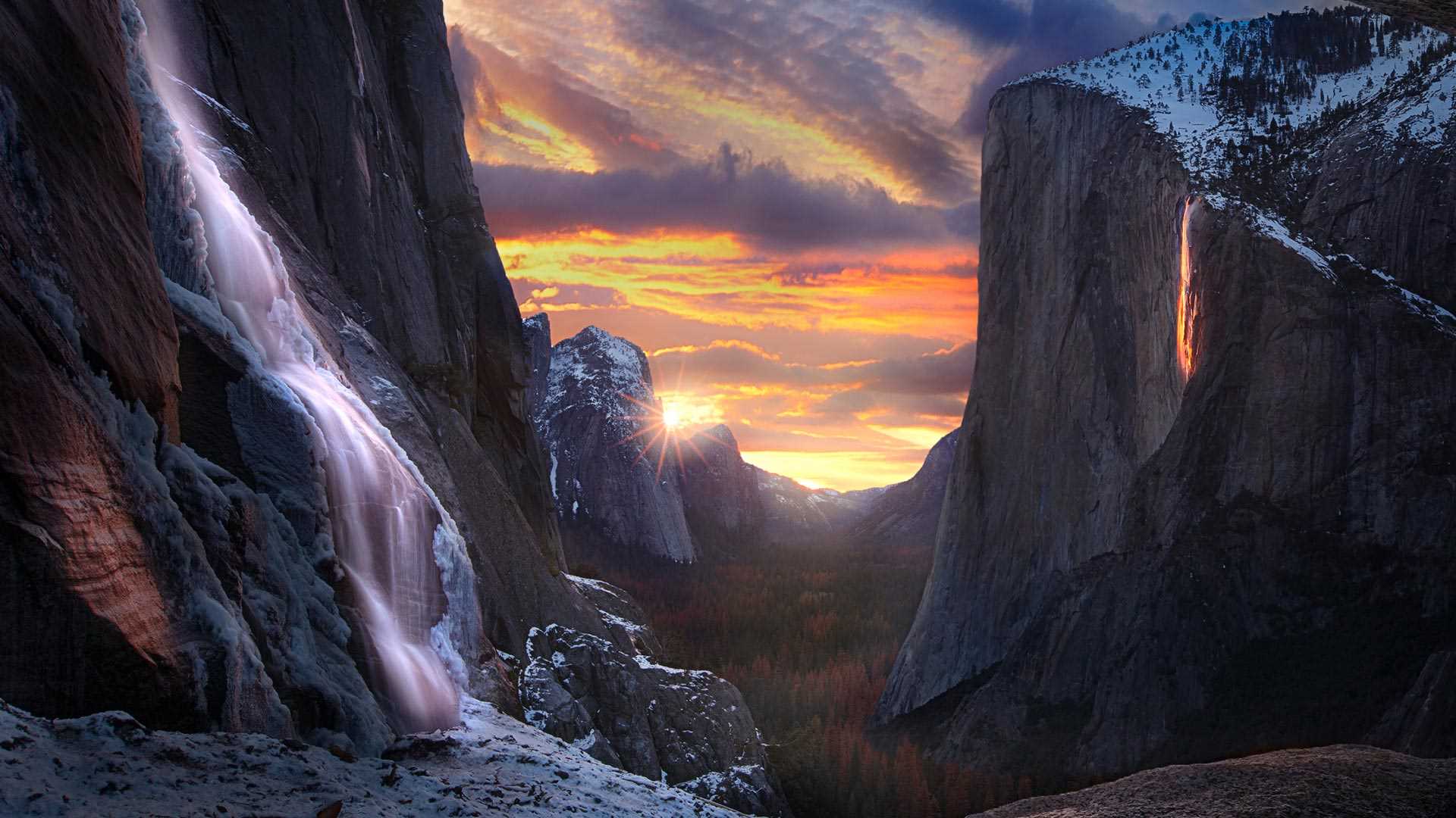
这个悬崖怎么着火了? Why is this cliffside ablaze?
马尾瀑布,约塞米蒂国家公园,加利福尼亚州
在约塞米蒂国家公园的埃尔卡皮坦山东侧,当所有自然条件齐备,马尾瀑布就像火一样“燃烧”起来。这种现象只有在2月的几周时间里可以看到,前提是天气晴朗,雪水或雨水形成瀑布,并且光照条件恰到好处。“火瀑布”只会持续大约10分钟,届时,观景区会人潮涌动。希望今年的游客能有幸看到这一神奇的自然景观。
Horsetail Fall, Yosemite National Park, California
When nature converges in rare and glorious fashion on the east side of the rock formation known as El Capitan, Horsetail Fall is illuminated as if on fire. This phenomenon can only be seen for a couple of weeks in February if there is a clear sky, enough water flowing from snowmelt or rain, and perfect timing. This 'firefall' only lasts for around 10 minutes and vantage points can be crowded. Horsetail Fall and El Capitan are part of Yosemite National Park, the second-oldest national park in the US. We hope this year's visitors are fortunate enough to see this magical display.
死亡谷扎布里斯基角上空的银河,美国加利福尼亚州 The Milky Way over Zabriskie Point, Death Valley, California (© Matt Anderson Photography/Getty Images)
死亡谷扎布里斯基角上空的银河,美国加利福尼亚州 The Milky Way over Zabriskie Point, Death Valley, California (© Matt Anderson Photography/Getty Images)
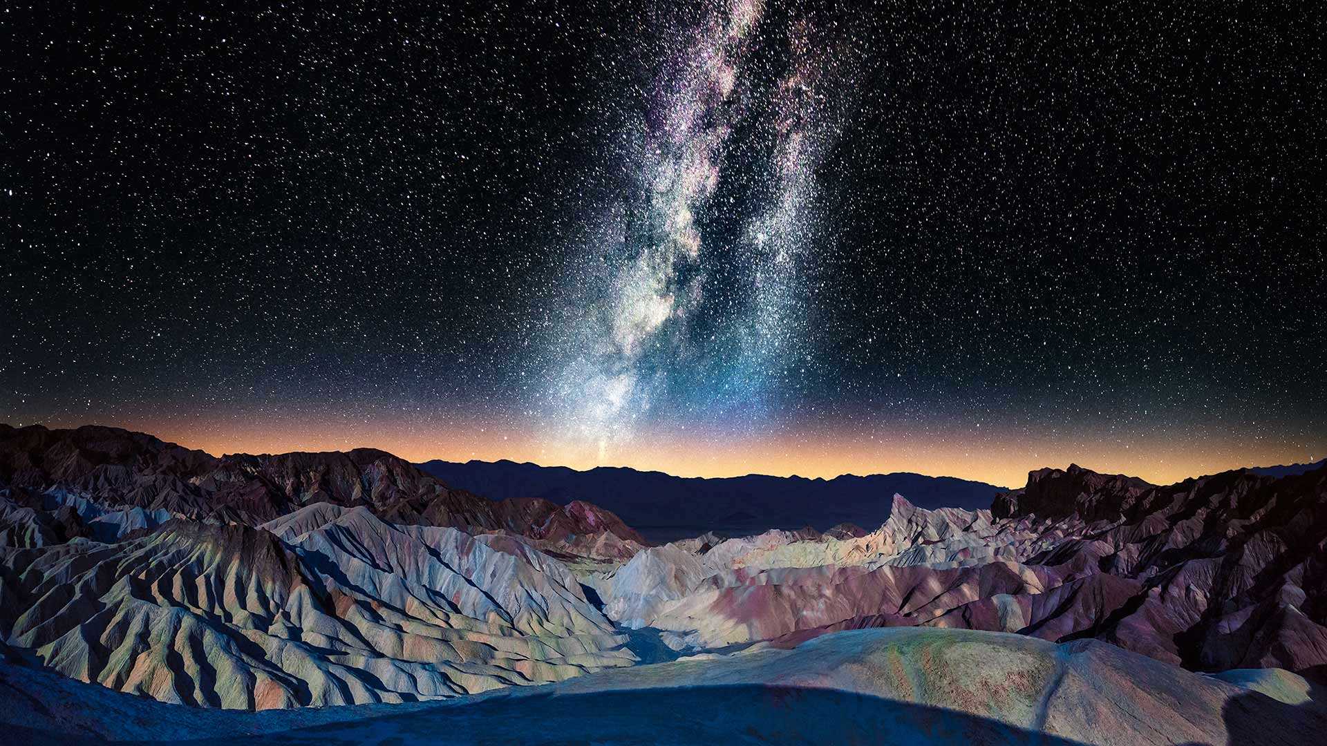
布满星星的天空 A sky full of stars
扎布里斯基角上空的银河,加利福尼亚州
扎布里斯基角的标志性景观是摄影师和游客一年四季蜂拥而至的原因之一。大自然在这些荒地上侵蚀了亿万年,形成了这片令人惊叹的条纹岩层。这几座山峰上的深色部分是由古代火山爆发的熔岩形成的。扎布里斯基角位于加利福尼亚州的死亡谷国家公园,是无数电影(如《斯巴达克斯》和《星球大战》)的取景地。爱尔兰摇滚乐队U2的音乐专辑《约书亚树》的封面也在这里取景。难怪死亡谷暗夜节在美国如此受欢迎。
Milky Way over Zabriskie Point, California
The iconic view from Zabriskie Point is one of the reasons why photographers and tourists flock to this spot all year round. Weather and water carved out these badlands for eons, resulting in this stunning striped rock formation with an array of colors. The darker material on several peaks was formed by lava of an ancient volcanic eruption, making some of these ridges higher than others. Nestled in Death Valley National Park, California, Zabriskie Point has been the backdrop of countless movies like 'Spartacus' and 'Stars Wars.' The scenic overlook is featured on the cover of Irish rock band U2's album, 'The Joshua Tree.' It's no wonder the Death Valley Dark Skies Festival is a hugely popular event. Zabriskie Point was named after Christian Zabriskie, a distinguished member of the Pacific Coast Borax Company from 1885 to 1933.
下羚羊峡谷,亚利桑那州,美国 Lower Antelope Canyon near Page, Arizona (© AZCat/Getty Images)
下羚羊峡谷,亚利桑那州,美国 Lower Antelope Canyon near Page, Arizona (© AZCat/Getty Images)
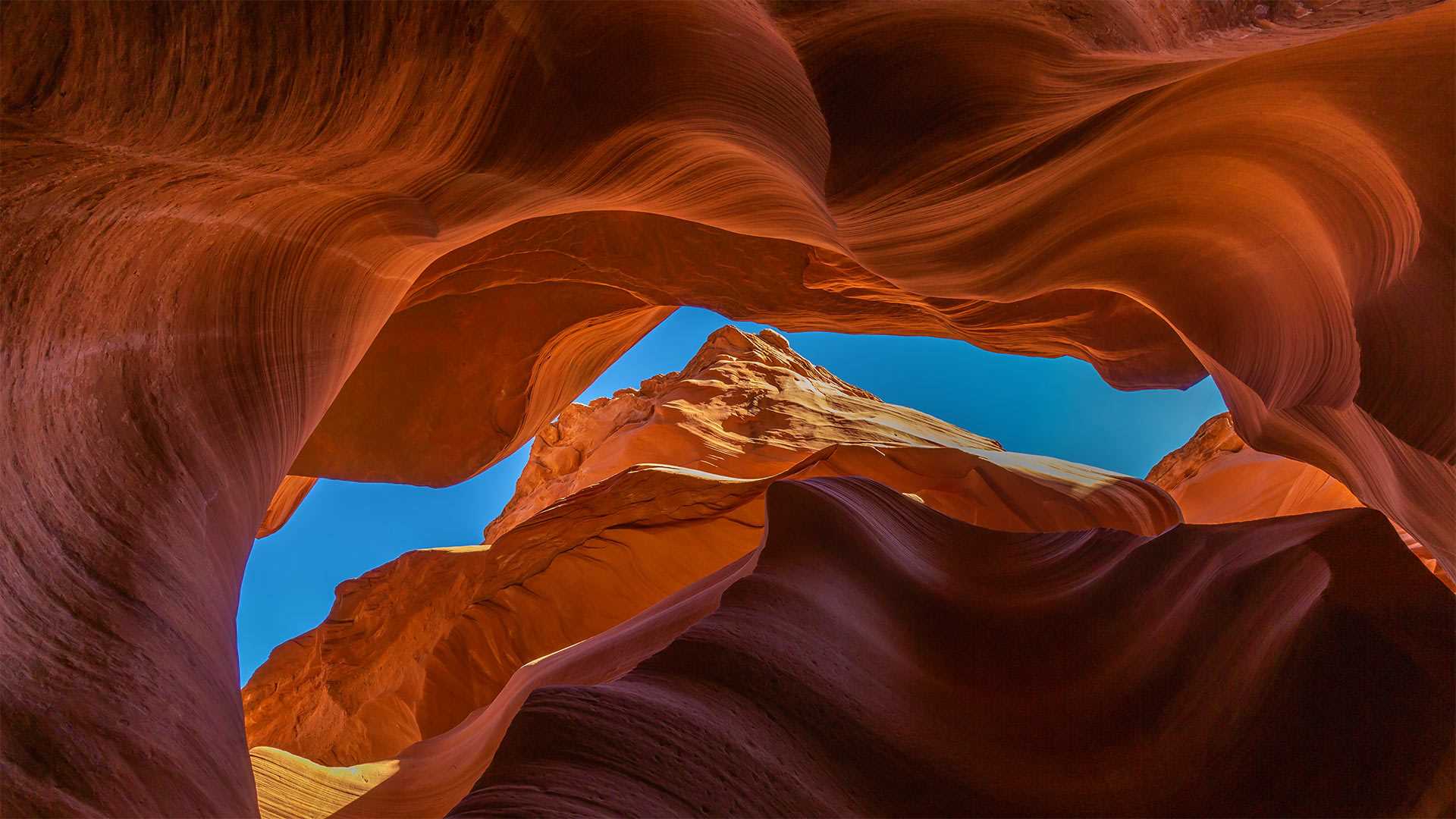
这些美丽的岩石波浪是什么? What are these beautiful sandy waves?
下羚羊峡谷,美国亚利桑那州
下羚羊峡谷是位于美国亚利桑纳州的一个美丽的自然景点。该峡谷也被原住民纳瓦霍人称为“螺旋石拱”。下羚羊峡谷不仅吸引了观景游客、徒步者,其鲜艳的色彩还吸引了许多摄影师。下羚羊峡谷呈“V”字形,这一独特的地貌是水流长年冲刷谷壁而形成的。羚羊峡谷的名字来源于纳瓦霍人的传说故事:过去,羚羊们会在冬天沿着峡谷漫步吃草。
Lower Antelope Canyon, Arizona
Lower Antelope Canyon is a beautiful natural tourist attraction located in Arizona. This canyon is also known as Hazdistazí (spiral rock arches) among the indigenous Navajo people. The canyon is not just a sight to behold and great for a hike, but with its beautiful hues is also a photographer's dream come true. The canyon is shaped like a 'V,' its unique geography created by water that rushed over its walls over many, many years. Antelope Canyon gets its name from Navajo stories regarding antelopes that grazed along the canyon in the wintertime.