一名男子从摩押附近的科罗纳拱门索降, 美国 A man rappels off Corona Arch near Moab, Utah (© Grant Ordelheide/TANDEM Stills + Motion)
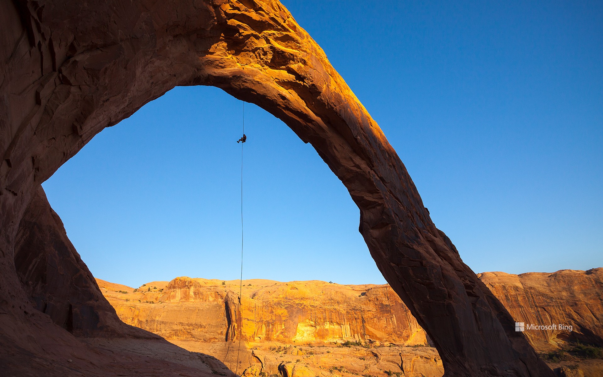
一名男子从摩押附近的科罗纳拱门索降, 美国 A man rappels off Corona Arch near Moab, Utah (© Grant Ordelheide/TANDEM Stills + Motion)
地球的公开秘密 Earth's open secret
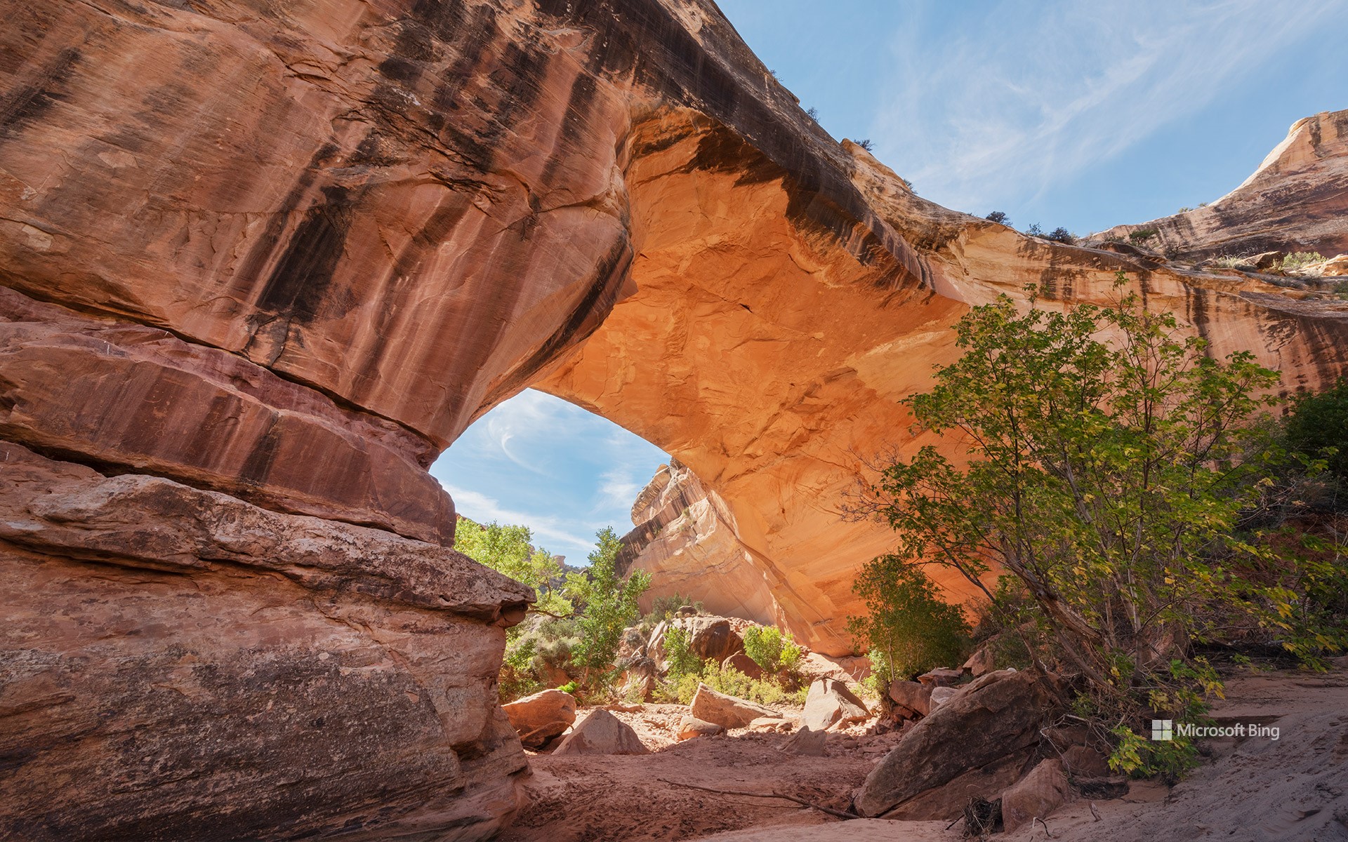
摩押附近的科罗纳拱门,犹他州
通往它的科罗纳拱门步道起初较为平坦,但沿途风光壮丽:穿越铁路轨道、攀爬光滑岩石,甚至需借助金属缆绳前行,让这段旅程远不只是一次在犹他州拱门国家公园之外,有一处如同通向天空的巨大门户般的自然奇观,吸引着摄影师、自然爱好者和徒步旅行者,那就是今日图片中所见的科罗纳拱门。这座巨大拱形岩石由纳瓦霍砂岩构成,是一处充满冒险却不拥挤的旅行目的地。普通的沙漠散步。步行约1.5英里后,你将抵达这座令人震撼的天然拱门,它宽达140英尺,高约105英尺,庞大的规模令人叹为观止。过去曾有人在拱门上系绳荡秋千,这种极限活动后来因安全原因被禁止。即便没有刺激的冒险,这次徒步旅程仍能让你在红岩地貌的心脏地带,欣赏到令人震撼的自然景观,留下难忘回忆。科罗纳拱门也被称为“小彩虹桥”,因其外形酷似鲍威尔湖附近的著名彩虹桥,但它独自坐落于更为宁静的天地之中,绽放着独特的自然魅力。
Corona Arch near Moab, Utah
Just outside Arches National Park in Utah lies a natural wonder that rises like a colossal doorway against the sky, drawing photographers, nature lovers, and hikers. Welcome to Corona Arch, seen in today's image, a towering Navajo sandstone formation that offers big adventure without the big crowds. The Corona Arch Trail starts off easy but packs a punch of scenery: railroad tracks, slickrock scrambles, and even a metal cable assist make it more than just a walk in the desert. After 1.5 miles of walking, the payoff is big: a massive arch that's 140 feet wide and 105 feet high. It's so large that people once swung from it on ropes, until that was banned for safety reasons. Even without the adrenaline stunts, the hike offers beautiful views and unforgettable moments in the heart of Red Rock Country. Also known as Little Rainbow Bridge, it shares visual similarities with the iconic Rainbow Bridge arch near Lake Powell—but Corona Arch holds its own in a more peaceful setting.
圆顶礁国家公园弗鲁塔附近的岩画, 犹他州, 美国 Petroglyphs near Fruita in Capitol Reef National Park, Utah (© Nicolas VINCENT/Adobe Stock)
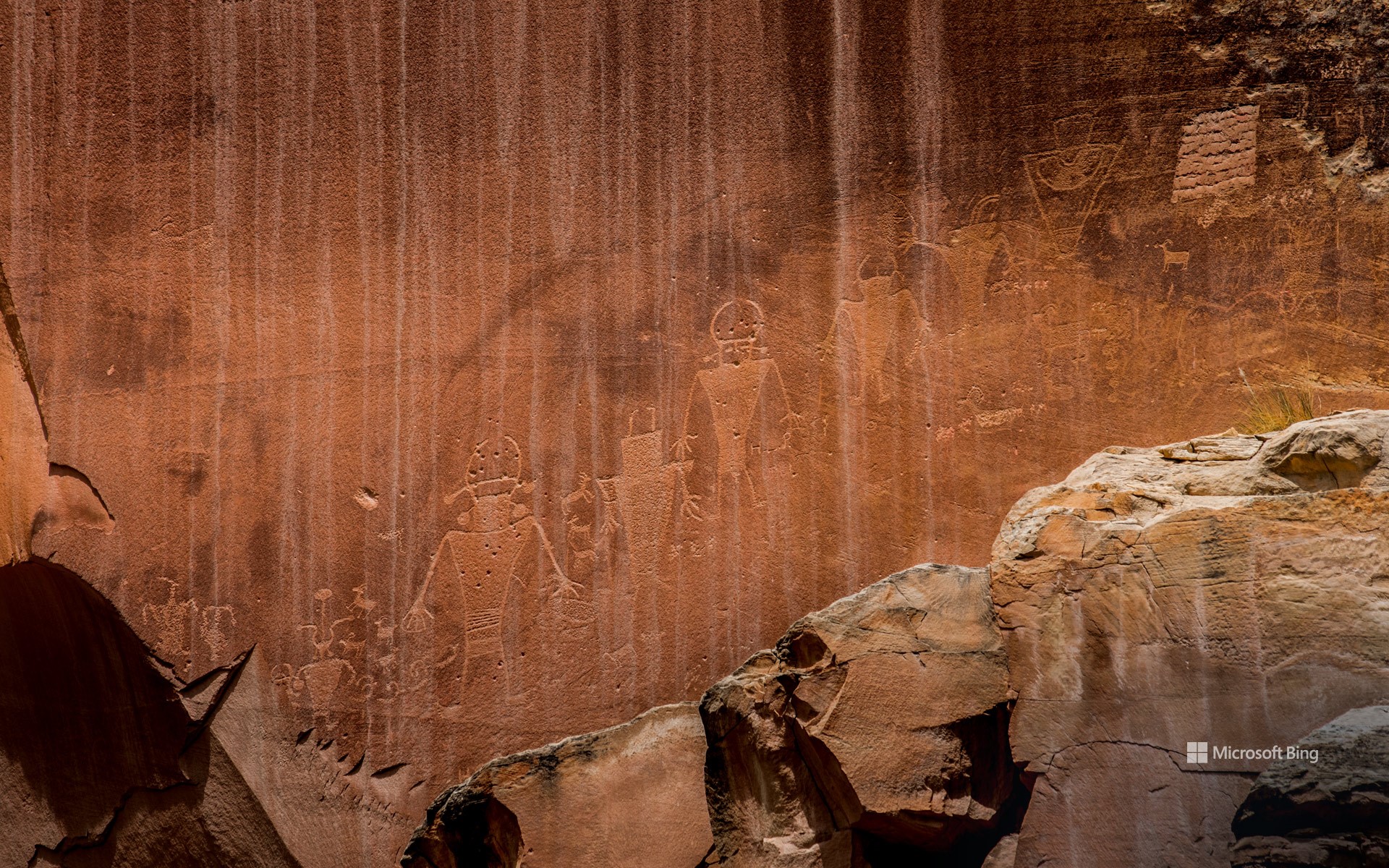
圆顶礁国家公园弗鲁塔附近的岩画, 犹他州, 美国 Petroglyphs near Fruita in Capitol Reef National Park, Utah (© Nicolas VINCENT/Adobe Stock)
古老的岩画 Age-old storyboard
圆顶礁国家公园弗鲁塔附近的岩画, 犹他州, 美国
圆顶礁国家公园拥有一种亘古不变的魅力。在这里,红色的岩石峭壁、蜿蜒的峡谷与古老的故事,在犹他州沙漠的天空下彼此交织。1971年,这里被正式指定为国家公园。它不仅因鲜明的地质景观而引人驻足,更因那刻印在大地上的古老叙事与文化遗产而让人驻足沉思。
早在游客们穿上徒步靴踏上圆顶礁的步道之前,弗里蒙特人和祖先普韦布洛人便已在此居住。从公元300年至1300年,他们在地穴屋和天然岩穴中生活,将农业巧妙地融入狩猎采集的日常。他们与这片土地的联系既具有精神层面的意义,也具备实际的生活用途。他们在此留下了公园最引人注目的遗迹之一:岩画,比如今日图片中在弗鲁塔地区发现的岩画。这些岩画展示了一种古老的视觉语言,刻画着戴头饰、佩珠宝的人形形象,旁边还有大角羊和蜥蜴等动物图案,以及象征仪式、迁徙和天文现象的抽象符号。这些共同构成了一座无声的档案库,记录着那些曾在这片非凡土地上生活、迁徙并赋予其意义的人们的故事。
Petroglyphs near Fruita in Capitol Reef National Park, Utah
There's something timeless about Capitol Reef National Park—a place where red rock cliffs, winding canyons, and ancient stories come together under Utah's desert sky. Designated a national park in 1971, Capitol Reef invites reflection—not just on its vivid geology, but on the ancient narratives and cultural heritage etched into its landscape.
Long before visitors laced up hiking boots and hit the trails at Capitol Reef, the Fremont and Ancestral Puebloan peoples called this place home. Between 300 and 1300 CE, they lived in pit houses and natural rock shelters, weaving farming into their hunter-gatherer lifestyle. Their connection to the land was both spiritual and practical—and they left behind some of the park's most captivating features, including petroglyphs like those found in Fruita, featured in today's image. These rock panels showcase an ancient visual language, featuring human figures adorned with headdresses and jewelry. Alongside them are animals like bighorn sheep and lizards, as well as abstract shapes alluding to ceremonies, migrations, and celestial events. Together, they form a silent archive—a timeless record of the people who lived, moved, and made meaning in this extraordinary landscape.
精致拱门, 拱门国家公园, 犹他州, 美国 Delicate Arch, Arches National Park, Utah (© mmac72/Getty Images)
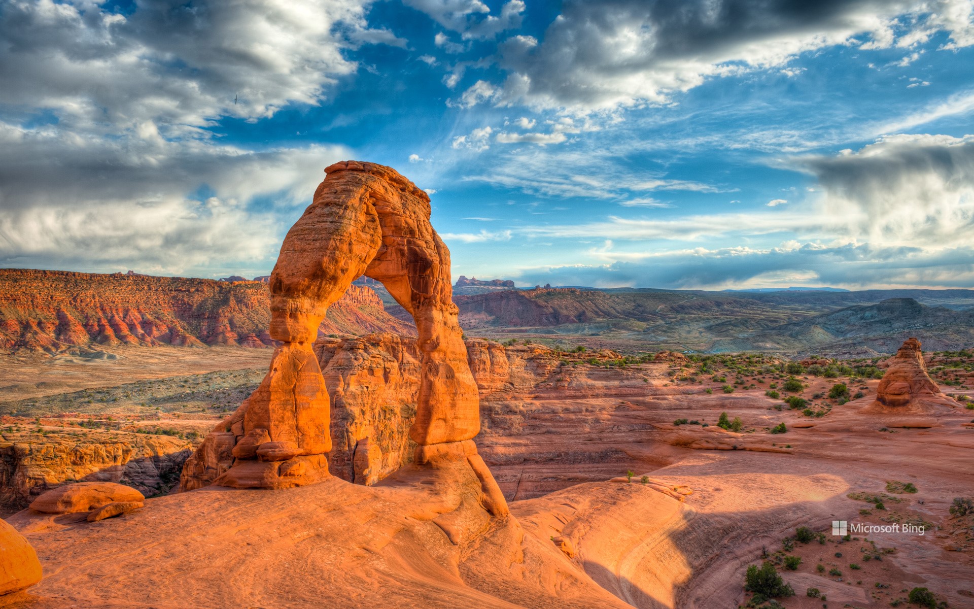
精致拱门, 拱门国家公园, 犹他州, 美国 Delicate Arch, Arches National Park, Utah (© mmac72/Getty Images)
大自然的耐心之作 Nature took its time
精致拱门, 拱门国家公园, 犹他州, 美国
这片景观并非一朝一夕形成,而是大自然历经漫长岁月的雕琢之作。你在美国犹他州拱门国家公园所见的一切,是3亿多年间地壳抬升、风化与侵蚀共同作用的结果。这些天然拱门最初由古海洋遗留下的盐层构成,在时间推移中,砂岩层开裂、位移并不断风化,最终形成了超过2000座天然拱门。这些地貌主要由恩特拉达砂岩与纳瓦霍砂岩构成。该地区于1929年被认定为国家纪念地,并于1971年正式升格为国家公园。
其中最著名的拱门,便是今日图像所展示的精致拱门。它是美国西南部最具代表性的天然拱门之一。早期曾被称为“马裤”或“盐溪拱门”,直到1930年代,一次科学考察团队将其描述为“外观精致”,从而得名“精致拱门”。如今,精致拱门已成为犹他州的非官方象征,频繁出现在该州车牌、广告宣传,甚至印在1996年为纪念犹他建州百年而发行的美国邮票上。前往精致拱门需完成一段中等难度的徒步路线,途中需攀登光滑岩面,贴近悬崖边缘前行。无论你是地质爱好者,还是寻求壮丽自然景观的旅行者,这座拱门都将为你带来难以忘怀的震撼体验。
Delicate Arch in Arches National Park, Utah
This landscape wasn't built overnight—nature took its time to craft it. What you see at Arches National Park in Utah, is the result of over 300 million years of erosion, uplift, and weathering. Over time, layers of sandstone cracked, shifted, and slowly wore away, revealing more than 2,000 natural arches. The formations are made mostly of Entrada and Navajo sandstone. The area was recognized as a national monument in 1929 and was upgraded to national park status in 1971.
The distinctive shape of Delicate Arch, seen here, has made it one of the most recognizable natural arches in the Southwest. Originally known by several other names—including the Chaps and Salt Wash Arch—it wasn't officially called Delicate Arch until the 1930s. It is Utah's unofficial mascot, appearing on everything from state license plates to a US postage stamp issued in 1996 to mark 100 years of Utah statehood. The arch is accessible via a moderately difficult hike that climbs over bare rock and skirts steep drop-offs. Whether you're a geology enthusiast or simply looking for a view worth the effort, Delicate Arch delivers.
拱门国家公园双拱门映衬下的银河,犹他州,美国 The Milky Way framed by Double Arch in Arches National Park, Utah (© Adventure_Photo/Getty Images)
拱门国家公园双拱门映衬下的银河,犹他州,美国 The Milky Way framed by Double Arch in Arches National Park, Utah (© Adventure_Photo/Getty Images)
让我们一起庆祝宇宙 Let's celebrate the cosmos
国际天文日快乐!
你是否曾好奇,通过望远镜看到的土星环是什么样子?又或者,天文学家是如何发现遥远星系的?国际天文日正是探索这些奥秘的绝佳时机!这一年度活动最早于 1973 年发起,其官方主题是:“将天文学带给大众”。 从当地公园到天文俱乐部、博物馆,再到天文台,游客们可以参与望远镜观测、太空讲座,甚至体验模拟月球重力的装置!这一想法起源于加利福尼亚的一位天文学家道格·伯杰。他不再等待人们走进天文台,而是直接把望远镜带到热闹的公共场所。这一招奏效了,人们很快就迷上了仰望星空!如今,世界各地都在庆祝国际天文日,加拿大、瑞典、阿根廷等许多国家都有举办相关活动。今天,就是探索宇宙的好时机。找一架望远镜,一起仰望星空、庆祝宇宙的壮丽吧!
Happy International Astronomy Day!
Ever wondered what Saturn's rings look like through a telescope? Or how astronomers spot distant galaxies? International Astronomy Day is the perfect time to find out. This annual event, first launched in 1973, is all about 'Bringing Astronomy to the People'—the official theme of Astronomy Day. From local parks to astronomy clubs, museums, and observatories, visitors can enjoy activities like telescope viewings, space talks, and even moon gravity simulators.
The event started when Doug Berger, an astronomer in California, decided to take telescopes to busy public spaces rather than wait for people to visit observatories. It worked—people got hooked on stargazing. Astronomy Day is celebrated worldwide, with events in countries like Canada, Sweden, and Argentina, among many others. Today is the day to explore the universe. Find a telescope and celebrate the cosmos!
锡安国家公园,犹他州,美国 (© Simon Dannhauer/Getty Images)
锡安国家公园,犹他州,美国 (© Simon Dannhauer/Getty Images)
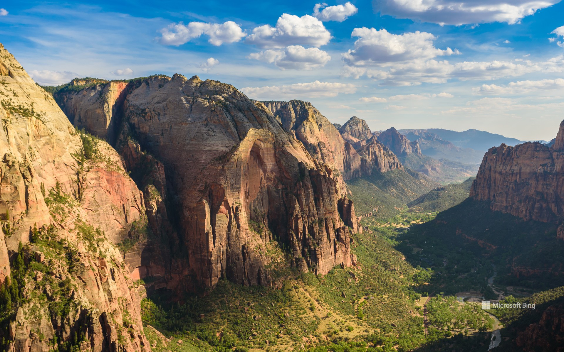
国家公园周开始了
锡安国家公园,犹他州,美国
穿上你的登山靴——国家公园周开始了!这个为期九天的活动从今天开始,鼓励人们探索并欣赏国家公园的自然美景与文化遗产。这是一个了解这些受保护区域、参与保护工作、并享受壮丽景观的绝佳时机。可以通过参观国家公园、分享这些自然宝藏的信息,来加入这一庆祝活动,同时也感受它们在国家遗产中所扮演的重要角色。
今日图片展示的是锡安国家公园,这是一个很好的起点。该公园位于犹他州西南部,占地232 平方英里,地貌独特,拥有壮观的砂岩悬崖和狭窄的缝隙峡谷。锡安国家公园拥有丰富的动植物资源,包括近 300 种鸟类和19 种蝙蝠。是不是很吸引人?锡安国家公园只是全美 400 多个国家公园中的一个。国家公园周是一个深入了解它们并亲近大自然的绝佳机会。
卡奇纳桥,天然桥国家区,犹他州,美国 Kachina Bridge, Natural Bridges National Monument, Utah (© Alan Majchrowicz/Getty Images)
卡奇纳桥,天然桥国家区,犹他州,美国 Kachina Bridge, Natural Bridges National Monument, Utah (© Alan Majchrowicz/Getty Images)
时光通道 A passage through time
纪念天然桥国家保护区成立周年,犹他州
在犹他州东南部偏远的峡谷深处,天然桥国家保护区静静地诉说着时间与自然的力量。这里坐落着三座壮丽的天然桥:西帕普桥、卡奇纳桥和欧瓦乔莫桥。这些名字来源于曾在此生活的阿纳萨齐祖先印第安人,向他们的文化遗产致敬。其中,西帕普桥是最大的一座,其巨大的桥洞足以容纳美国国会大厦的圆顶。位于西帕普和欧瓦乔莫之间的卡奇纳桥,以桥基处发现的岩画和壁画而得名。而欧瓦乔莫桥被认为是三座桥中最古老的一座,其纤细的拱形结构表明它可能最终会自然坍塌。
1908年的今天,美国总统西奥多·罗斯福宣布此地为犹他州首座国家纪念地,以保护这一奇观。如今,这片神秘而壮丽的土地依旧保持着原始风貌。游客可以沿着小径徒步穿行,在高耸的天然桥下驻足仰望,感受大自然鬼斧神工的杰作,或是在这片以漆黑夜空闻名的保护区里,欣赏璀璨银河铺满天际的壮观景象。
Anniversary of Natural Bridges National Monument, Utah
Within the remote canyons of southeastern Utah, Natural Bridges National Monument highlights the power of erosion and the passage of time. Shaped by the relentless forces of wind and water, this monument features three magnificent natural bridges—Sipapu, Kachina, and Owachomo. These bridges were named to honor the Ancestral Puebloans who once lived here. Sipapu is the largest bridge, with a massive opening that could almost fit the dome of the United States Capitol. Kachina, pictured here, is equidistant from Sipapu and Owachomo. It was named after the petroglyphs and pictographs found at its base. Owachomo is believed to be the oldest of the three. Its thin, arching structure suggests it may eventually collapse.
Recognizing the significance of these natural wonders, President Theodore Roosevelt designated Natural Bridges as Utah's first national monument on this day in 1908. Today, it remains a place of awe and solitude, where visitors can hike beneath the soaring bridges, gaze at some of the darkest night skies in the country, and step back into a landscape sculpted over millions of years.
凯恩维尔附近荒地的砂岩地层, 犹他州, 美国 Sandstone formations in the badlands near Caineville, Utah (© Chris Moore/TANDEM Stills + Motion)
凯恩维尔附近荒地的砂岩地层, 犹他州, 美国 Sandstone formations in the badlands near Caineville, Utah (© Chris Moore/TANDEM Stills + Motion)
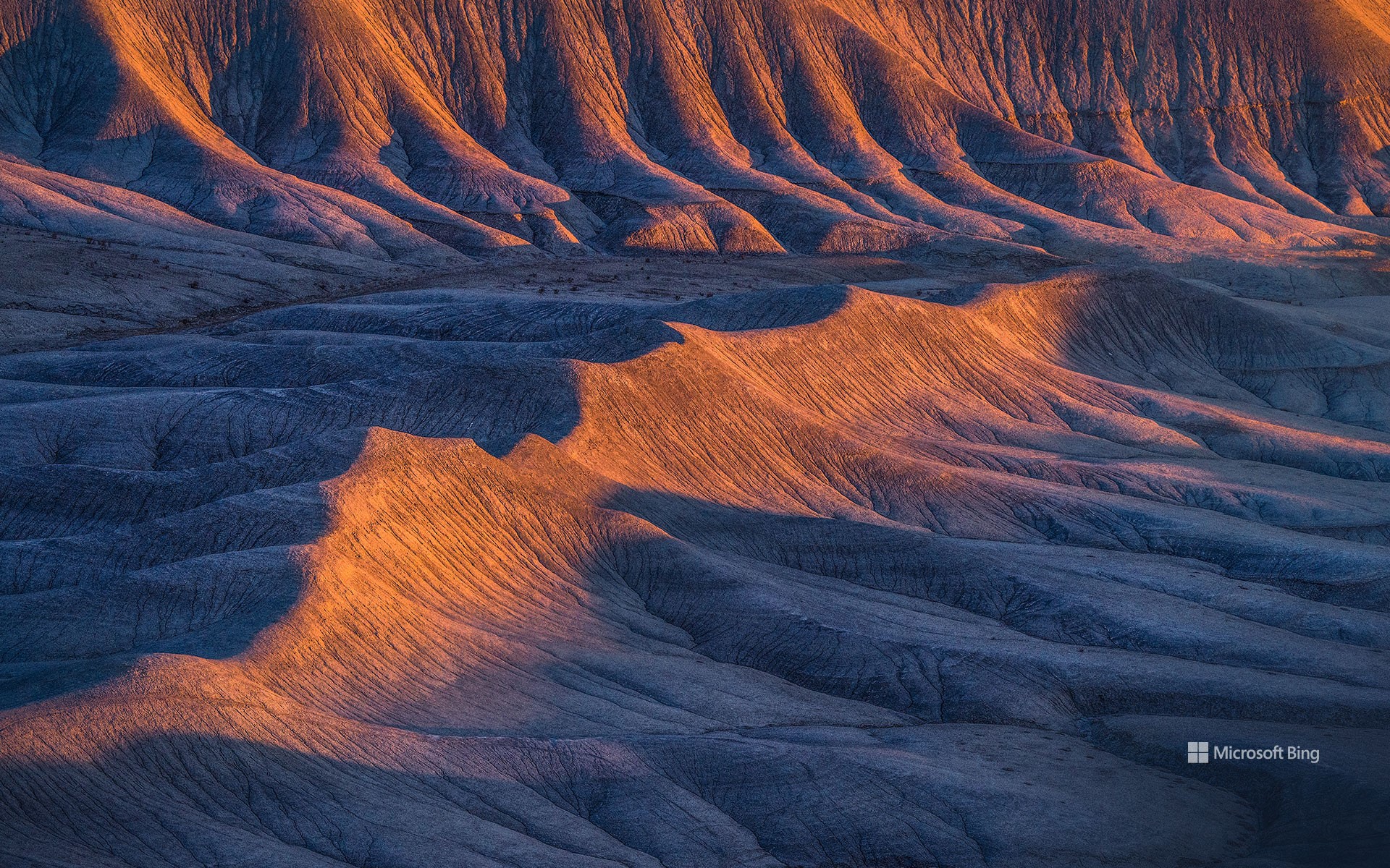
时间的波浪 Waves of time
凯恩维尔附近荒地的砂岩地层, 犹他州, 美国
蜿蜒起伏的砂岩脊绵延于犹他州凯恩维尔荒地,宛如大自然在石头上绘制的笔触。这些地貌由细粒沉积物构成,最初沉积在古代河流三角洲和内陆海洋中,随后逐渐硬化为岩石。随着时间的推移,侵蚀作用穿透了这些地层,露出流动般的波纹状图案。沉积岩层记录着气候变迁和古老地貌的演变。今日图片中,这片荒凉的土地看似毫无生机,但在早春时节,降雨会让大地铺满紫色和黄色的小花。一天的不同时刻,光影不断变化,展现出不同的角度与风貌,为摄影师和游客提供了丰富的观赏体验。尽管这片崎岖不平的地形大部分仍然保持原始状态,但部分区域地势较为平缓,允许游客在无需剧烈攀爬的情况下轻松探索。
荒地广布于除南极洲以外的所有大陆。早期探险者在穿越这些艰难地形时遭遇重重困难,因此赋予它们“荒地”之名。古生物学家经常能在这里发现史前生物的化石遗骸。尽管环境极端,这些土地依然孕育着丰富的生命,包括沙漠植物、蜥蜴和鸟类。
Sandstone formations in the badlands near Caineville, Utah
Wavy sandstone ridges stretch across the Caineville Badlands in Utah, resembling nature's brushstrokes on stone. These formations are made of fine-grained sediment that settled in ancient river deltas and inland seas and later hardened into stone. Over time, erosion carved through the layers, exposing flowing, ripple-like patterns. The sedimentary layers tell a story of shifting climates and ancient landscapes. The barren land may appear lifeless, but during early spring, rainfall causes the terrain to be blanketed with tiny purple and yellow flowers. While much of the terrain remains rugged, some areas offer easy access, allowing visitors to explore without strenuous hiking.
Badlands exist on every continent except Antarctica. Early explorers named them after struggling to navigate harsh terrains. Fossil hunters frequently uncover remnants of prehistoric creatures in the eroded hills. Despite the extreme conditions, badlands support a wide range of life, including desert plants, lizards, and birds.
砂岩石柱,布莱斯峡谷国家公园,犹他州,美国 Sandstone hoodoos, Bryce Canyon National Park, Utah (© Stephen Matera/TANDEM Stills + Motion)
砂岩石柱,布莱斯峡谷国家公园,犹他州,美国 Sandstone hoodoos, Bryce Canyon National Park, Utah (© Stephen Matera/TANDEM Stills + Motion)
风蚀石们的问候 Hoodoo you do?
布莱斯峡谷国家公园,犹他州,美国
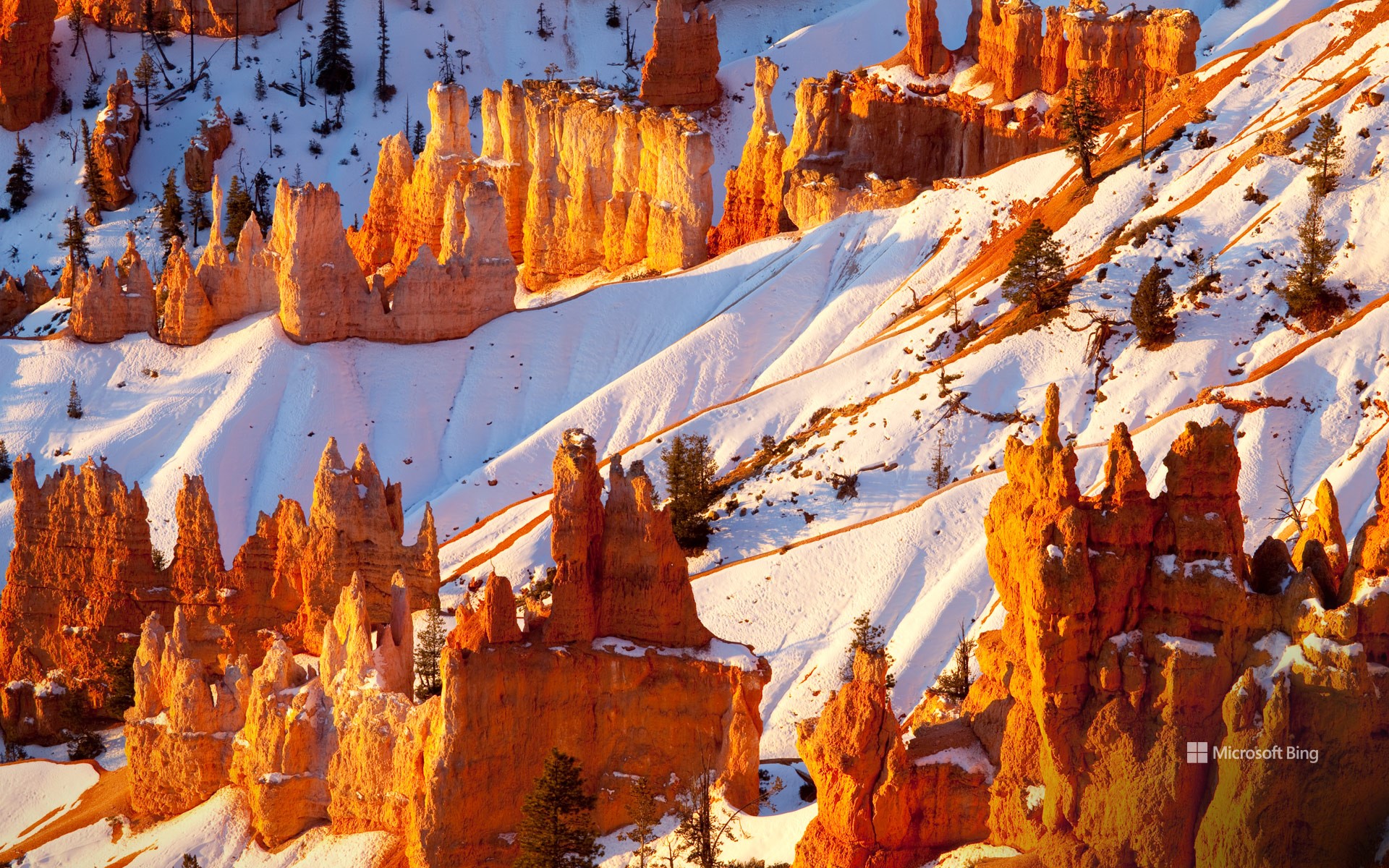
在美国犹他州,布莱斯峡谷国家公园以其壮观的砂岩迷宫和独特的岩柱景观闻名于世。这里的历史可追溯至少10,000年前,曾是阿纳齐族人、普韦布洛人和派尤特人的家园。公园里的岩柱是由侵蚀作用形成的高耸岩石尖塔,在派尤特部落的创世神话中占据重要地位。根据传说,这些岩柱曾是“传说中的人”, 因狡猾的郊狼施下的诅咒而化为石头。
18世纪末至19世纪初,首批欧洲裔美国人抵达这一地区,并在1850年代开始定居。布莱斯峡谷的名字源自埃比尼泽·布莱斯这一位早期定居者,他在峡谷附近拥有一块土地。1928 年的今天,布莱斯峡谷正式被指定为国家公园。如今,该公园以岩柱闻名,每年吸引超过 200 万游客前来欣赏这一地质奇观。事实上,布莱斯峡谷国家公园拥有地球上最密集的岩柱群,为游客提供了一场视觉盛宴。
Anniversary of Bryce Canyon National Park
A breathtaking maze of sandstone formations and awe-inspiring views awaits you at Bryce Canyon National Park in Utah. People have lived in this area for at least 10,000 years, including the Anasazi, Pueblo, and Paiute Peoples. The hoodoos—tall, thin spires of rock formed by erosion—in the park inspired Paiute mythology: They believed them to be the Legend People turned to stone by the trickster Coyote.
The first European Americans arrived in the area in the late 18th and early 19th centuries, and some eventually settled there in the 1850s. Bryce Canyon was named after Ebenezer Bryce, who had a homestead nearby. On this date in 1928, Bryce was declared a national park. These days, the park is famous for its hoodoos. Every year, over 2 million visitors come to marvel at these geological formations. In fact, Bryce Canyon National Park has the highest concentration of hoodoos anywhere on Earth.
阿尔斯特罗姆角,鲍威尔湖,犹他州,美国 Alstrom Point, Lake Powell, Utah (© T.M. Schultze/TANDEM Stills + Motion)
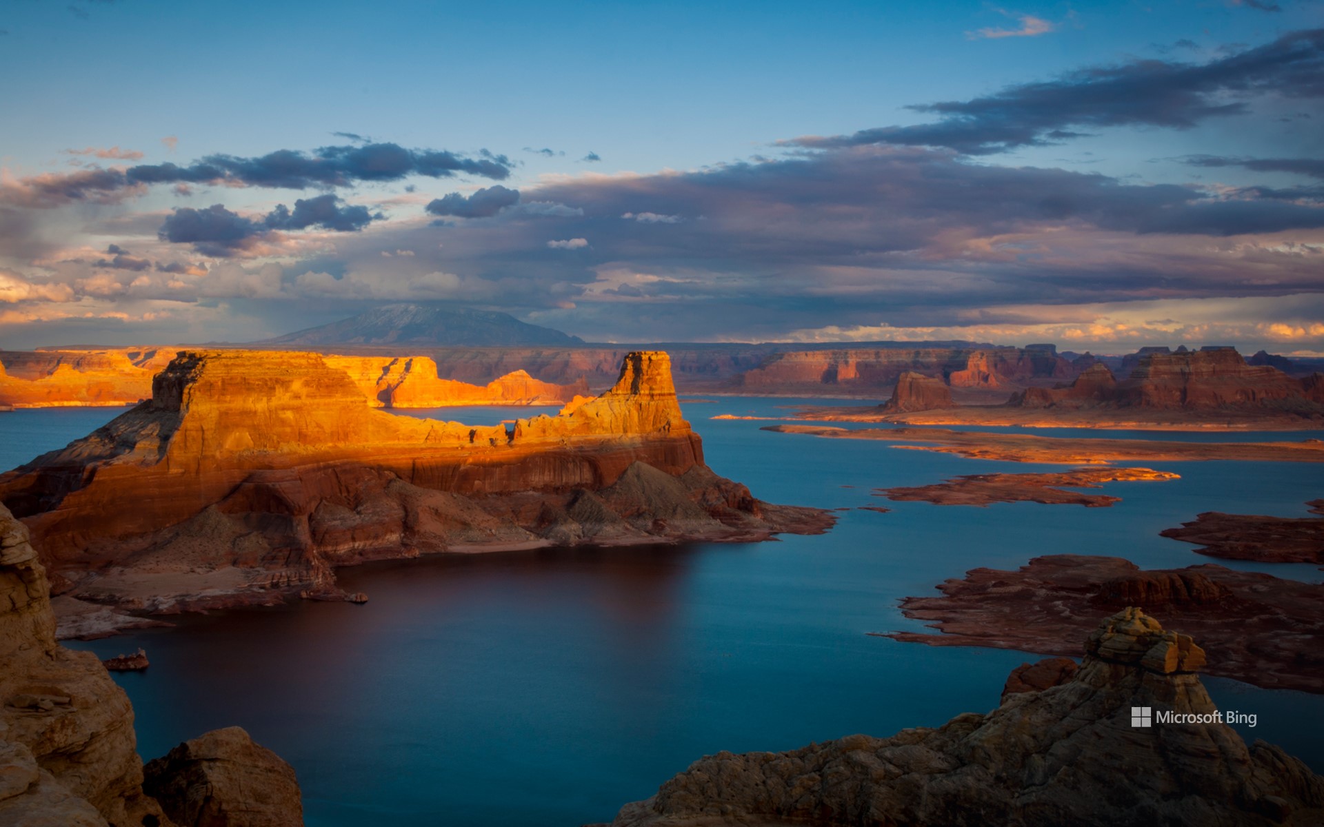
阿尔斯特罗姆角,鲍威尔湖,犹他州,美国 Alstrom Point, Lake Powell, Utah (© T.M. Schultze/TANDEM Stills + Motion)
值得深思的高地 A point worth pondering
阿尔斯特罗姆角,鲍威尔湖
如果你向往壮丽的日落和令人惊叹的美景,不妨来到阿尔斯特罗姆角。阿尔斯特罗姆角位于犹他州南部凯恩县的格伦峡谷国家休闲区,海拔达4685英尺。阿尔斯特罗姆角主要由恩特拉达砂岩构成,与附近的罗马纳梅萨主峰及东侧的冈赛特山共享相同的地质起源。
作为鲍威尔湖地区的一部分,阿尔斯特罗姆角向南延伸至湖泊辽阔水域,位于帕德雷湾与沃姆溪湾之间。湖水蓄满时,阿尔斯特罗姆角高出水面近1000英尺,可俯瞰周围峡谷。鲍威尔湖横跨犹他州与亚利桑那州,每年吸引约300万游客前来。这片湖泊由深蓝色水流组成迷宫般的网络,蜿蜒穿过90多个岩石峡谷。湖泊的主要部分流经格伦峡谷,同时延伸至多个较小支流峡谷,以及埃斯卡兰特河与圣胡安河区域。
Alstrom Point, Lake Powell, Utah
If you're chasing sunsets and jaw-dropping views, come to Alstrom Point. Located in southern Utah's Kane County, this spot in the Glen Canyon National Recreation Area stands at an impressive height of 4,685 feet. Made mostly of Entrada Sandstone, it has the same geological roots as nearby sites like Romana Mesa, its parent peak, and Gunsight Butte, another sandstone summit to the east.
Part of the Lake Powell region, Alstrom Point extends southward into the vast waters of the lake, in between Padre Bay and Warm Creek Bay. When the lake is full, Alstrom Point towers nearly 1,000 feet above the water, offering views of the surrounding canyons. Lake Powell, spanning across Utah and Arizona, attracts around 3 million visitors every year. The lake is a maze of deep blue water winding through over 90 rock canyons. While its main stretch runs through Glen Canyon, it also snakes into over many smaller side canyons, along with the Escalante and San Juan Rivers.
黄昏时的鹿谷,帕克城,犹他州,美国 Deer Valley at dusk, Park City, Utah (© Adventure_Photo/Getty Images)
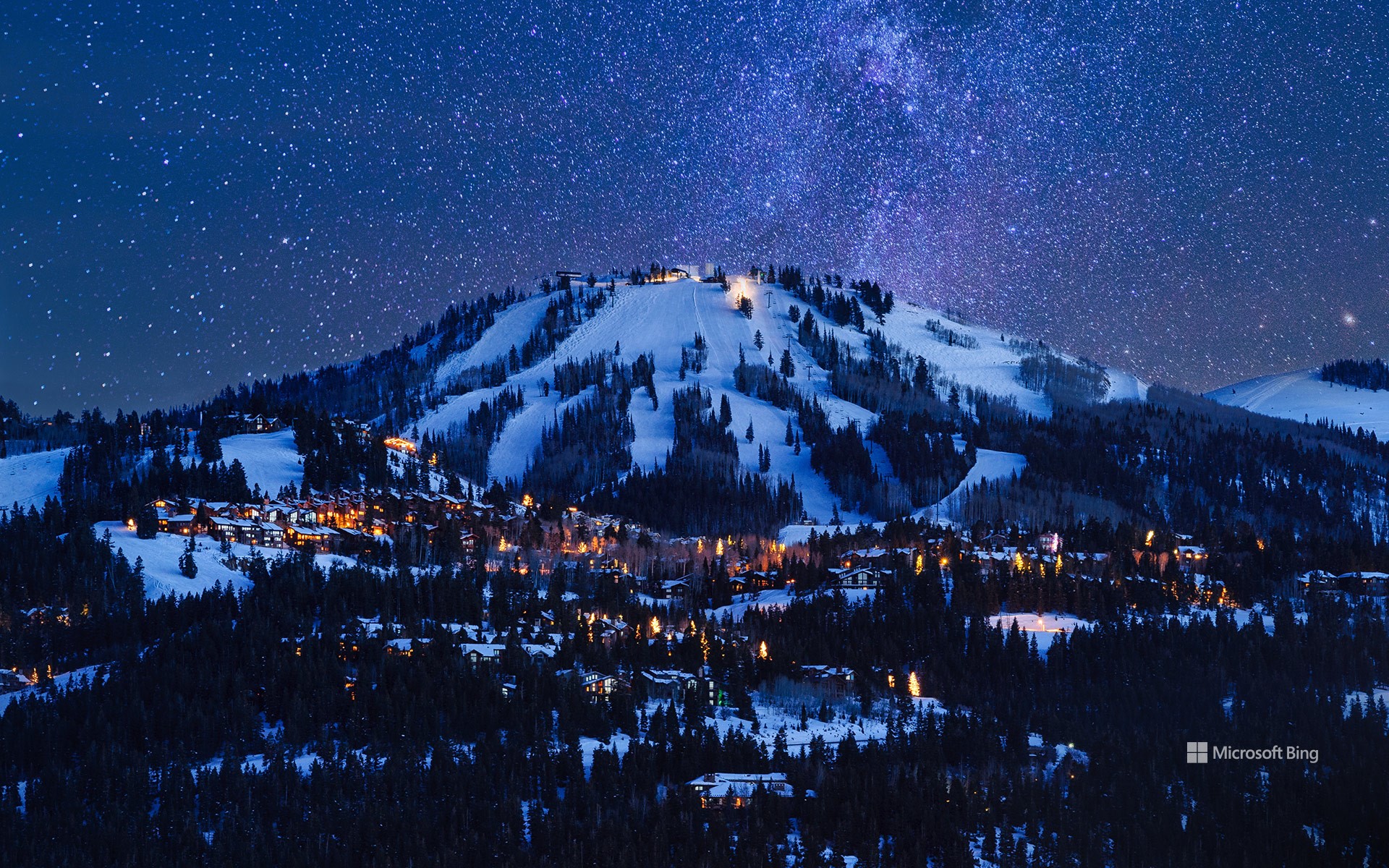
黄昏时的鹿谷,帕克城,犹他州,美国 Deer Valley at dusk, Park City, Utah (© Adventure_Photo/Getty Images)
电影、山脉和魔法 Movies, mountains, and magic
鹿谷,帕克城,犹他州,美国
今天,圣丹斯电影节拉开帷幕,以犹他州的群山为背景,庆祝电影的魅力。电影节的中心是帕克城,它是圣丹斯活力四射的主办城市之一,活动在犹他州的多个地点举行。每年一月,这个宁静的旅游胜地都会变成一个热闹的创意中心,吸引来自世界各地的电影制作人和电影爱好者。除了银幕,帕克城也值得一游。这里拥有迷人的风景、鹿谷和帕克城山等顶级滑雪胜地,以及无尽的户外探险活动,从徒步旅行、骑自行车到泡温泉,应有尽有。无论你是来看电影还是寻求刺激,帕克城圣丹斯电影节都将为你带来难忘的体验。
Sundance Film Festival
Today, the Sundance Film Festival kicks off, celebrating the magic of movies against the backdrop of Utah's mountains. As a launchpad for groundbreaking films and emerging talent, Sundance has come a long way since its humble beginnings in 1978. Now one of the film industry's most influential events, it has introduced the world to talents like Quentin Tarantino and Steven Soderbergh, whose early works premiered here before shaping their iconic careers. With competitive sections for dramatic and documentary movies, from features to shorts, the festival offers an inspiring array of storytelling.
At its heart is Park City, pictured here, one of Sundance's vibrant host cities—the event takes place across several Utah locations. Every January, this quaint destination transforms into a buzzing hub of creativity, drawing filmmakers and cinephiles from across the globe. Beyond the silver screen, Park City is worth exploring. It boasts stunning landscapes, top-tier ski resorts like Deer Valley and Park City Mountain, and endless outdoor adventures, from hiking and biking to soaking in nearby hot springs. Whether you're here for the films or the thrills, Sundance in Park City promises an unforgettable experience.