2022年8月
旧金山湾的盐滩 Salt flats in San Francisco Bay (© Jeffrey Lewis/Tandem Stills + Motion)
旧金山湾的盐滩 Salt flats in San Francisco Bay (© Jeffrey Lewis/Tandem Stills + Motion)
一个咸咸的地点 A salty situation
San Francisco Bay salt flat
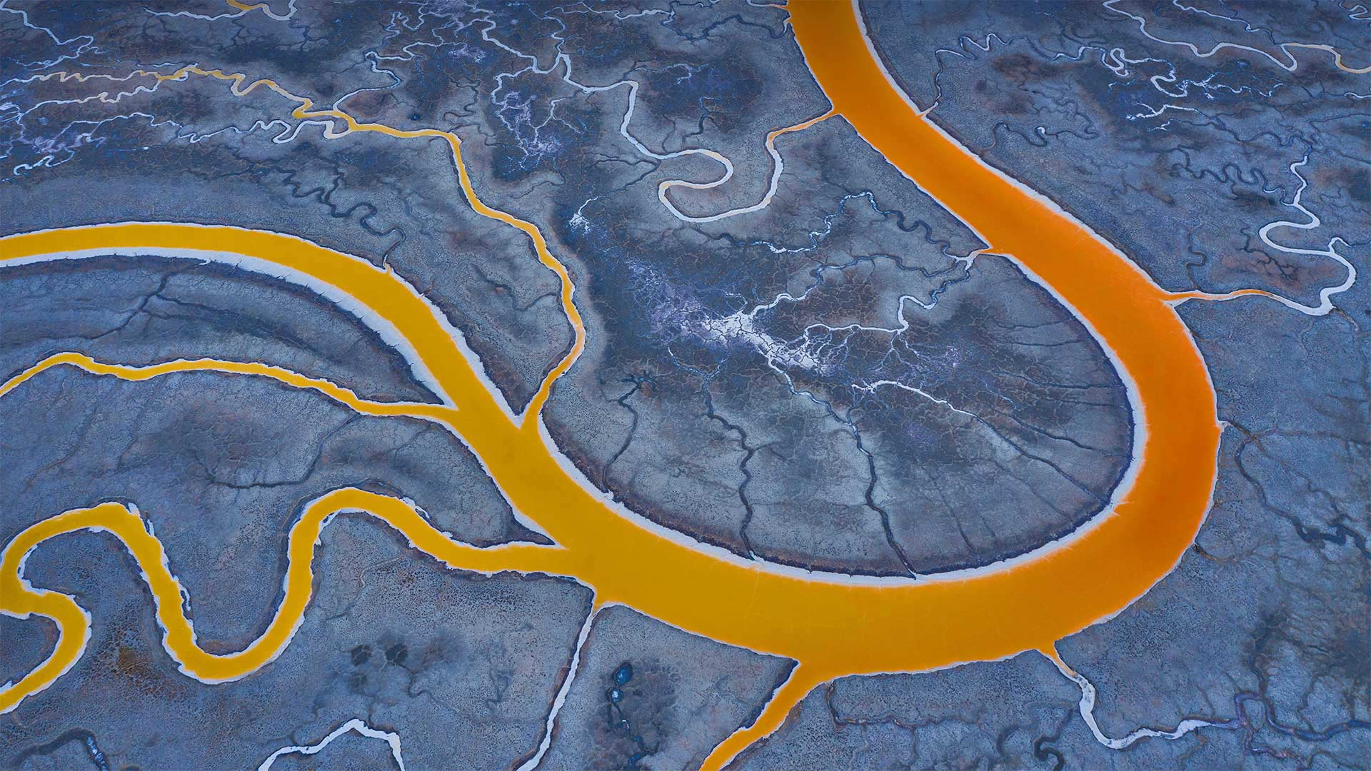
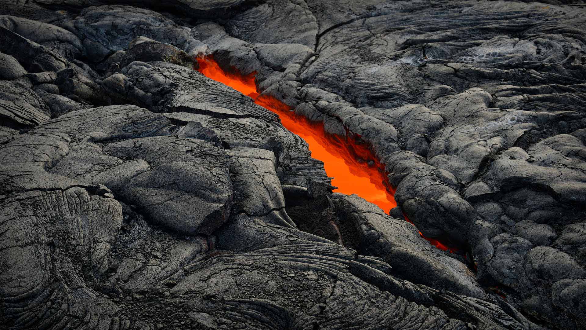
You might be wondering where the volcano is in today's photo, but that's not lava. These are salt evaporation ponds in San Francisco Bay. If you happen to be in the air and flying over this part of the country, you'll notice not just the bright orange but various greens and blues and even magenta pools that are part of the famous salt ponds. The vibrant colors are determined by brine shrimp, algae, and other microorganisms and their responses to different levels of salt. This orange results from about a mid-level saline concentration and the presence of tiny brine shrimp in the water. Green indicates low levels of salt, while pink or red are signs of high salt content in an algae-rich pond.
When Spanish explorers and missionaries arrived in the area in the late 18th century, members of the Indigenous Ohlone people were already extracting salt from the naturally occurring ponds. The California Gold Rush (1848–1855) brought waves of settlers to the region, and salt became one of San Francisco's largest industries. Roughly 80% of the wetland was eventually lost to salt mining, landfill, or other industrial alteration. But since 2003, many of these tidal flats have been acquired by federal and state agencies as well as private foundations to be restored to their original state. The restoration process will take decades, but even as the wetlands are being restored, about half a million tons of sea salt are harvested from the ponds every year.
旧金山湾盐滩
你可能想知道今天照片中的火山在哪里,但那不是熔岩。这些是旧金山湾的盐蒸发池。如果你碰巧在空中飞过这个国家的这一地区,你不仅会注意到明亮的橙色,还会注意到各种绿色和蓝色,甚至是品红池,它们是著名盐池的一部分。鲜艳的颜色是由盐水虾、藻类和其他微生物及其对不同盐含量的反应决定的。这种橙色是由于大约中等浓度的盐水和水中存在微小的盐水虾造成的。绿色表示含盐量低,而粉色或红色表示富藻池塘的含盐量高。
18世纪末,当西班牙探险家和传教士抵达该地区时,当地的奥隆人已经在从天然池塘中提取盐。加利福尼亚淘金热(1848-1855)为该地区带来了一波又一波的定居者,盐业成为旧金山最大的产业之一。大约80%的湿地最终因盐矿开采、填埋或其他工业改造而消失。但自2003年以来,联邦和州政府机构以及私人基金会收购了许多这些潮滩,以恢复其原始状态。恢复过程将需要几十年,但即使湿地正在恢复,每年从池塘中收获约50万吨海盐。
夜晚的爱丁堡城市天际线,苏格兰 Edinburgh city skyline at night, Scotland (© Suranga Weeratuna/Alamy)
夜晚的爱丁堡城市天际线,苏格兰 Edinburgh city skyline at night, Scotland (© Suranga Weeratuna/Alamy)
节日热潮 Festival fever
Edinburgh festivals
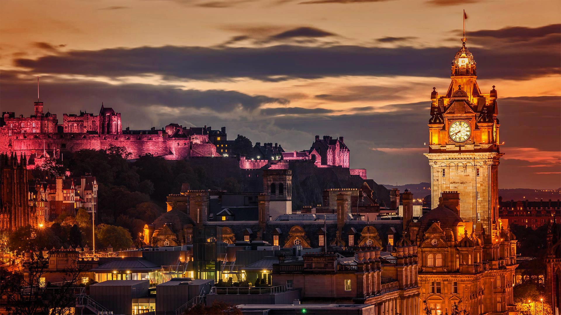
Here's the world-famous Edinburgh Castle, lit up in all its glory as it keeps watch over Scotland's capital city. Today the castle hosts the Royal Edinburgh Military Tattoo, a full-on Scottish experience, with bagpipes, drums, and seemingly enough kilts to cover all of Scotland. Enthusiastic visitors can also indulge in whisky and haggis in one of the many hostelries on the Royal Mile, the colorful, bustling historic street that wends its way from the castle down to the Palace of Holyroodhouse, Queen Elizabeth II's official residence in Scotland.
The Tattoo is a spectacular show of military music, dancing, and ceremony that runs alongside the Edinburgh International Festival, which starts today and goes through August 27, and the Edinburgh Festival Fringe (Aug. 5-29), its sprawling, less formal sidekick. The main festival—celebrating its 75th anniversary in 2022—is an invitation-only event that brings together top classical musicians and stage performers from around the globe. The Fringe is decidedly casual. It's the world's largest arts festival and features all types of music, street performers, amateur theater productions, stand-up comedy, and more, often in city streets, church halls, pubs...basically any available space. Think free-spirited and fun. One thing's certain: Edinburgh in August keeps everyone entertained.
爱丁堡音乐节
这是举世闻名的爱丁堡城堡,它在守卫苏格兰首都的同时,灯火通明。今天,城堡里有皇家爱丁堡军事纹身,这是一次充满苏格兰风情的经历,风笛、鼓和方格呢短裙似乎足以覆盖整个苏格兰。热情的游客还可以在皇家大道(Royal Mile)上的众多招待所之一尽情享受威士忌和哈吉斯酒。皇家大道是一条色彩斑斓、熙熙攘攘的历史街区,从城堡一直延伸到伊丽莎白女王二世在苏格兰的官邸霍利罗德豪斯宫(Palace of Holyroodhouse)。
纹身是一场壮观的军事音乐、舞蹈和仪式表演,与爱丁堡国际艺术节(从今天开始,一直持续到8月27日)和爱丁堡边缘艺术节(8月5日至29日)同时举行。爱丁堡艺术节是其规模庞大、不太正式的伙伴。2022年庆祝其75周年的主要节日是一个邀请活动,汇集了来自世界各地的顶级古典音乐家和舞台表演者。流苏绝对是随意的。这是世界上最大的艺术节,以各种类型的音乐、街头艺人、业余戏剧制作、单口喜剧等为特色,通常在城市街道、教堂大厅、酒吧……基本上是任何可用空间。想一想自由和乐趣。有一件事是肯定的:八月的爱丁堡让每个人都很开心。
上海浦东森林心形洞穴鸟瞰图,中国 Aerial view of heart shaped cave in the forest, Pudong, Shanghai, China (© Yaorusheng/Getty Images)
上海浦东森林心形洞穴鸟瞰图,中国 Aerial view of heart shaped cave in the forest, Pudong, Shanghai, China (© Yaorusheng/Getty Images)
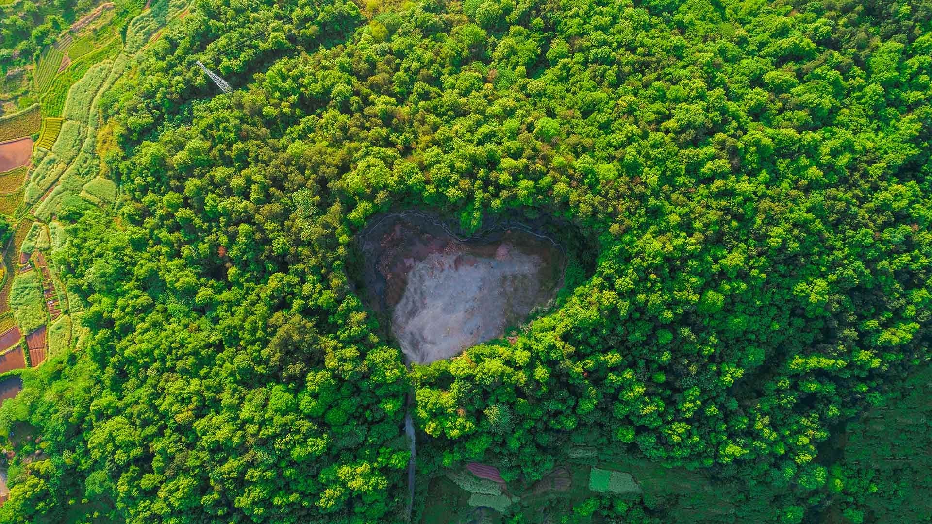
最浪漫的中国传统节日 The most romantic traditional festival
QiXi Festival
Derived from the worship of stars, the Tanabata Festival is the birthday of the seventh sister in the traditional sense. The seventh sister (VEGA) is a weaver of clouds and the textile industry, and the patron saint of lovers, women, and children. The Tanabata Festival is not only a festival to worship the seventh sister, but also a festival of love. It is a comprehensive festival with women as the main body, with the folk legend of "Cowherd and Weaver Girl" as the carrier, with praying, begging, and love as the theme.
With the development of history, QiXi has been endowed with the beautiful love legend of "Cowherd and Weaver Girl". Because it is endowed with the connotation related to love, it has become a festival symbolizing love, which is considered to be a very romantic traditional festival in China and has produced the cultural meaning of "Chinese Valentine's Day" in contemporary times.
七夕节
七夕节源于对星星的崇拜,在传统意义上是七姐的生日。七姐妹(织女星)是云和纺织业的编织者,是情人、妇女和儿童的守护神。七夕节不仅是祭拜七姐的节日,也是爱的节日。这是一个以妇女为主体,以民间传说“牛郎织女”为载体,以祈祷、乞讨、爱情为主题的综合性节日。
随着历史的发展,七夕被赋予了“牛郎织女”的美丽爱情传说。由于它被赋予了与爱相关的内涵,它已成为象征爱的节日,在中国被认为是一个非常浪漫的传统节日,并在当代产生了“中国情人节”的文化意义。
圆顶礁国家公园里的希克曼桥,美国犹他州 The Hickman Bridge at Capitol Reef National Park, Utah (© Tim Fitzharris/Minden Pictures)
圆顶礁国家公园里的希克曼桥,美国犹他州 The Hickman Bridge at Capitol Reef National Park, Utah (© Tim Fitzharris/Minden Pictures)
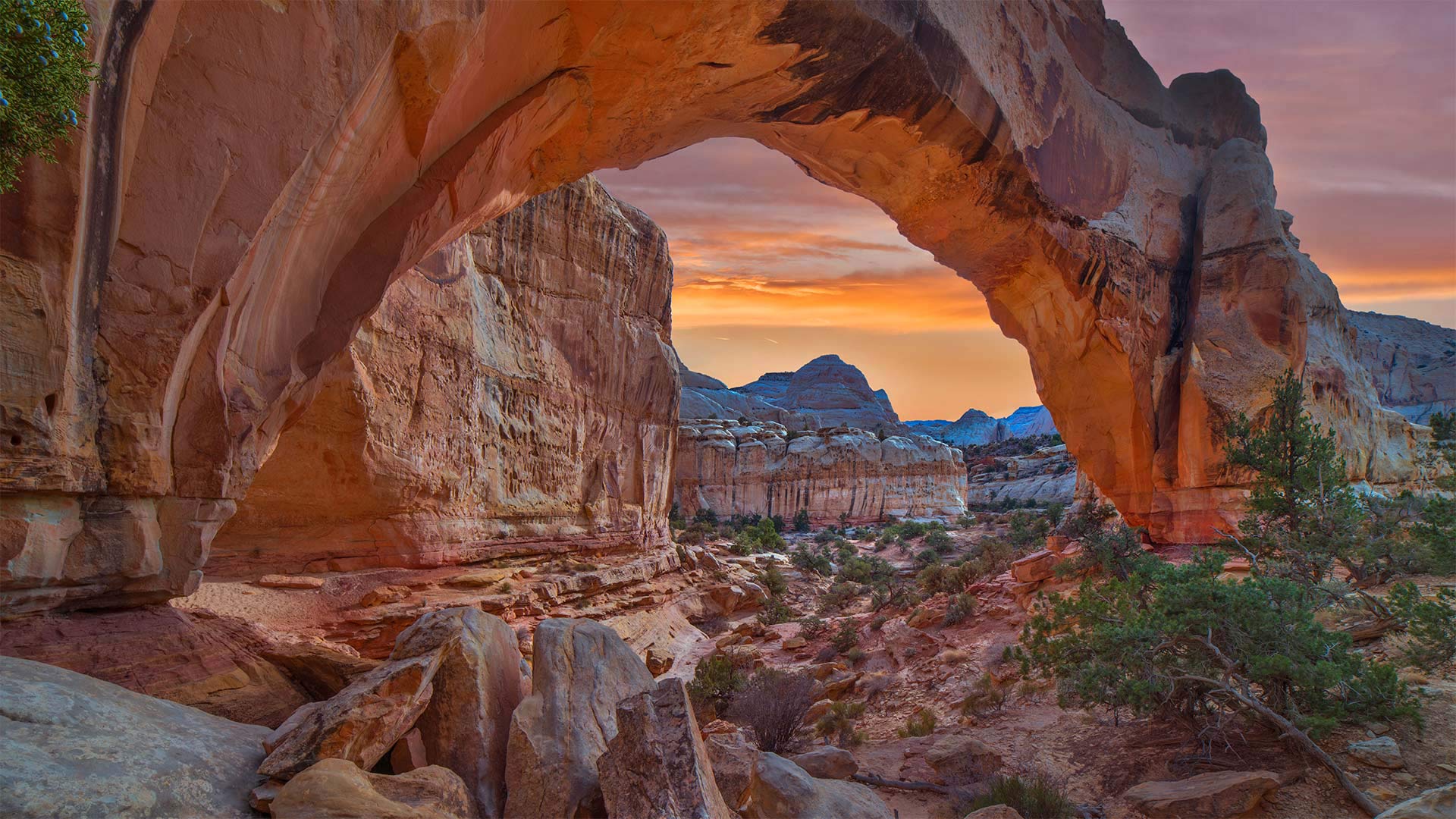
走上这条人迹常见的小径 Take the trail more traveled by
Happy Birthday Capitol Reef National Park
You won't find a lot of solitude on the Hickman Bridge Trail, a 1.7-mile route in Capitol Reef National Park that leads to this magnificent natural arch. The trail is used by hikers, runners, and nature lovers drawn by incredible rock formations, gullies, and remnants from the Fremont Culture Native American civilization from the early part of the 20th century. Hickman Bridge itself is one of the best-known geologic features of the park.
Capitol Reef National Park was first established as a national monument on this day in 1937, then became a national park in 1971. Capitol Reef is named for its massive rock domes that reminded nearby residents of that famous rotunda of the US Capitol Building back in Washington, DC. Why Capitol 'Reef,' though? Because the imposing formations were major obstacles to travelers through the region, the same way a coral reef is an obstacle to sailors.
The geology of the park is defined by the nearly 100-mile Waterpocket Fold, a wrinkle in the Earth's crust that formed around the end of the dinosaur era. Wind, rain, and time have eroded the Navajo Sandstone into colorful canyons, buttes, and natural arches like Hickman Bridge. The dramatic rock formations make Capitol Reef a favorite destination in the American West.
生日快乐国会山珊瑚礁国家公园
在希克曼大桥小径上你不会发现太多的孤独,这条小径位于国会山礁国家公园,全长1.7英里,通往这座宏伟的天然拱门。这条小径供远足者、跑步者和自然爱好者使用,它们由难以置信的岩层、沟壑和20世纪早期弗里蒙特文化-美洲原住民文明的遗迹绘制而成。希克曼大桥本身就是公园最著名的地质特征之一。
国会山礁国家公园于1937年的今天首次作为国家纪念碑建立,然后在1971年成为国家公园。国会山礁以其巨大的岩石圆顶而命名,这让附近的居民想起了位于华盛顿特区的美国国会大厦的著名圆形大厅。然而,为什么国会大厦是“暗礁”?因为壮观的地形是该地区旅行者的主要障碍,就像珊瑚礁是水手的障碍一样。
公园的地质特征是近100英里的水袋褶皱,这是在恐龙时代末期形成的地壳褶皱。风、雨和时间把纳瓦霍砂岩侵蚀成了五颜六色的峡谷、山丘和希克曼大桥那样的天然拱门。引人注目的岩层使国会山礁成为美国西部最受欢迎的目的地。
漏出“天窗”的熔岩管,夏威夷火山国家公园 Skylight into an active lava tube, Hawaii Volcanoes National Park, Hawaii (© Tom Schwabel/Tandem Stills + Motion)
漏出“天窗”的熔岩管,夏威夷火山国家公园 Skylight into an active lava tube, Hawaii Volcanoes National Park, Hawaii (© Tom Schwabel/Tandem Stills + Motion)
世界上最活跃的火山 The most active volcano in the world
Hawai'i Volcanoes National Park at 106
The orange glow of a lava tube like the one pictured here is a frequent site on Hawaii's Kilauea, the youngest volcano on one of the youngest islands on Earth. In near constant eruption for the last 40 years, Kilauea is widely considered the most active volcano in the world and is the main attraction at Hawaii Volcanoes National Park, which was created on this day in 1916. The park, which was designated an International Biosphere Reserve and a World Heritage Site, also includes another active volcano, Mauna Loa, the world's most massive shield volcano—Mauna Loa last erupted in 1984. Together, they are among the most studied volcanoes in the world.
The volcanoes of the Big Island of Hawaii offer a real-time glimpse into the ongoing creation of the entire Hawaiian island chain, a process that has been underway for tens of millions of years. Hawaii as we know it owes its existence to a volcanic hotspot on the seafloor. Magma seeps from this hotspot and turns into solid rock. Once enough magma is extruded, the rock breaks the surface of the sea and becomes an island. The island continues to grow until the Pacific tectonic plate moves the island off the hotspot. The hotspot remains stationary, constantly creating new islands. In fact, the next Hawaiian island, named Loihi, is about 20 miles from Hawaii and 3,000 feet below the surface of the ocean. In less than 100,000 years, it is expected to replace the Big Island as the youngest island in the chain, and it too will have its turn at hosting visitors who buy timeshare condos.
Hawaiian religion credits the creation of Hawaii to Pele, the goddess of fire and volcanoes. Possessing a fiery temper and a passionate nature, she is said to make her home in the Halema'uma'u caldera here on Kilauea. From her volcano home she controls the flow of lava and frequency of eruptions. According to modern legend, she sometimes wanders near the park as an old woman wearing a red muumuu, with a white dog, as a warning that a new eruption is soon to come.
106号夏威夷火山国家公园
图中所示的橙色熔岩管辉光是夏威夷基拉韦厄岛上的一个常见地点,基拉韦耶岛是地球上最年轻岛屿之一上最年轻的火山。在过去40年中,基拉韦厄火山几乎持续喷发,被广泛认为是世界上最活跃的火山,是1916年创建的夏威夷火山国家公园的主要景点。该公园被指定为国际生物圈保护区和世界遗产,还包括另一座活火山,莫纳罗亚,世界上最大的盾状火山莫纳洛上次喷发是在1984年。加在一起,它们是世界上研究最多的火山之一。
夏威夷大岛上的火山可以实时观察整个夏威夷岛链的形成过程,这一过程已经持续了数千万年。众所周知,夏威夷的存在得益于海底的火山热点。岩浆从这个热点渗出,变成固体岩石。一旦足够的岩浆被挤出,岩石就会冲破海面,变成一个岛屿。该岛继续增长,直到太平洋构造板块将该岛移出热点。热点保持静止,不断形成新的岛屿。事实上,下一个夏威夷岛,名为Loihi,距离夏威夷约20英里,海拔3000英尺。预计在不到10万年的时间里,它将取代大岛,成为这一链条中最年轻的岛屿,轮到它接待购买分时度假公寓的游客。
夏威夷宗教将夏威夷的诞生归功于火与火山女神贝利。她脾气暴躁,生性热情,据说住在基拉韦厄岛的Halema'uma'u火山口。她在火山口的家中控制着熔岩的流动和喷发的频率。根据现代传说,她有时会在公园附近漫步,就像一个穿着红色muumuu的老妇人,带着一只白色的狗,作为新火山爆发即将到来的警告。
立陶宛的夜光云 Noctilucent clouds in Lithuania (© ljphoto7/Getty Images)
立陶宛的夜光云 Noctilucent clouds in Lithuania (© ljphoto7/Getty Images)
Noctilucent clouds
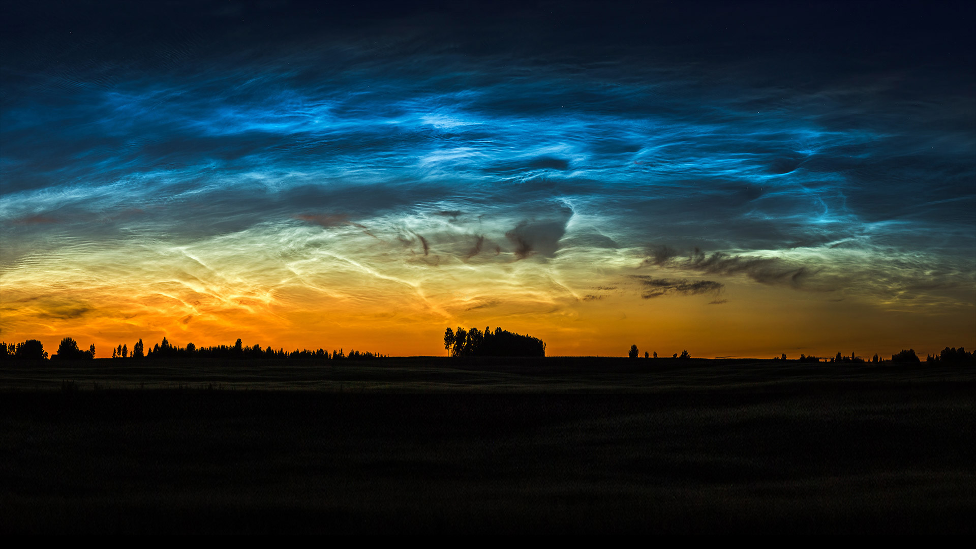
It's around this time of year when some lucky people get to witness these rare, wonderous clouds. Known as noctilucent, or ‘night shining,' clouds, they're the highest clouds in our sky and are only visible during summer. They're made up of icy dust glowing at the edge of space, roughly 50 miles above the planet's surface. The trick to seeing them is to gaze up into the sky at twilight, when the sun has already set on the Earth's surface, but the high-altitude noctilucent cloud is still in sunlight. These clouds occur almost exclusively at high latitudes, roughly between about 50° and 70° North or South.
Generally colorless or light blue, noctilucent clouds are distinct in their patterns of streaks, waves, and whirls. It's not fully known why they happen, though some recent studies suggest methane levels could contribute to atmospheric water vapor that rises high into the mesosphere where they form. What is known is that they were first observed in 1885, making them the newest cloud type.
夜光云
大约在每年的这个时候,一些幸运的人看到了这些罕见的、奇妙的云。夜光云是我们天空中最高的云,只有在夏天才能看到。它们是由在太空边缘发光的冰尘组成的,距离地球表面大约50英里。看到它们的诀窍是在黄昏时抬头仰望天空,这时太阳已经落在地球表面,但高海拔的夜光云仍在阳光下。这些云几乎只出现在高纬度地区,大约在南北50°到70°之间。
通常无色或淡蓝色,夜光云的条纹、波浪和漩涡图案不同。虽然最近的一些研究表明,甲烷含量可能会导致大气中的水蒸气上升到它们形成的中间层,但目前还不完全清楚它们为什么会发生。已知的是,1885年首次观察到甲烷含量,使其成为最新的云类型。