标签 德国 下的文章
多瑙河畔的帕绍市,巴伐利亚,德国 The city of Passau reflecting in the Danube river, Bavaria, Germany (© Scott Wilson/Alamy)
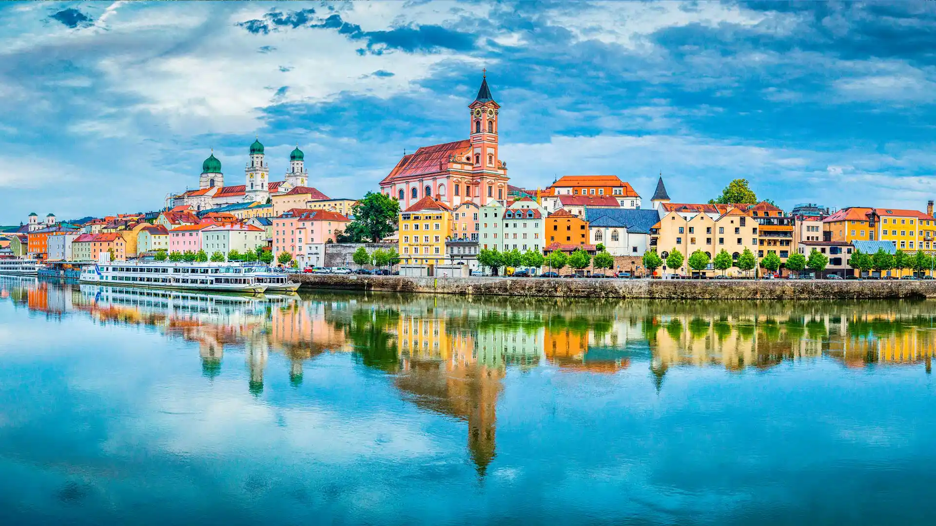
多瑙河畔的帕绍市,巴伐利亚,德国 The city of Passau reflecting in the Danube river, Bavaria, Germany (© Scott Wilson/Alamy)
巴洛克风盛宴 A Baroque treasure
帕绍,德国
帕绍位于德国的下巴伐利亚州,因为多瑙河、因河和伊尔茨河在此交汇,帕绍又被称作“三河之城”。帕绍以其哥特风格和巴洛克风格的建筑闻名。多瑙河和伊尔茨河之间的山上坐落着上韦斯特城堡和下韦斯特城堡,俯瞰着这座城市。
今天的帕绍是一座古老和现代相互交织的城市。从老城漫步到满是高端店铺的新中心,这一路上你会看到城市现代化的同时还保留着很多古老的传统。老城还有一个“艺术家区”——Höllgasse,这里的老房子里满是工作室、工坊和画廊。帕绍还有各种各样的美食,本地的酒吧和酒馆可以提供最棒的巴伐利亚和奥地利食物。
曼海姆水塔,德国 (© tichr/Getty Images)
大麦和矢车菊, 诺德豪森, 德国 (© Mandy Tabatt/Getty Images)
德国斯图加特公共图书馆 Stuttgart Public Library, Germany (© Axel Brunst/Tandem Stills + Motion)

德国斯图加特公共图书馆 Stuttgart Public Library, Germany (© Axel Brunst/Tandem Stills + Motion)
爱书人的天堂 A book lover's paradise
世界图书日
欧内斯特·海明威曾写道:“没有比一本书更忠诚的朋友了。”。在世界图书日之际,我们在德国斯图加特市向这些忠实的朋友致敬,那里一个巨大的整体立方体既是现代地标,也是城市图书馆的所在地。这座引人注目的建筑于2011年开业,由建筑师Eun Young Yi设计,在繁华的城市中成为一个平静、冥想的空间。它的内部是白色的,墙壁上排列的书籍提供了色彩的飞溅。
世界图书日由联合国教科文组织于1995年设立,旨在庆祝娱乐性阅读。这也标志着美国国家图书馆周的开始,所以没有比这更好的时间去当地的图书馆寻找下一个伟大的“朋友”,带你去新的冒险之旅。
World Book Day
'There is no friend as loyal as a book,' Ernest Hemingway once wrote. On World Book Day, we are honoring these loyal friends in the German city of Stuttgart, where a huge monolithic cube is both a modern landmark and home to the city library. Opened in 2011, this striking building was designed by architect Eun Young Yi to be a calming, meditative space in a bustling city. Its interior is white, with splashes of color provided by the books that line its walls.
World Book Day was set up by UNESCO in 1995 to celebrate recreational reading. It also marks the start of National Library Week here in the US, so there's no better time to head to your local library to find your next great 'friend' to take you on new adventures.
盛开的野蒜,海尼希国家公园,德国 (© Frank Sommariva/Getty Images)
吕贝克的霍尔斯滕门,德国 The Holsten Gate in Lübeck, Germany (© Harald Nachtmann/Getty Images)
吕贝克的霍尔斯滕门,德国 The Holsten Gate in Lübeck, Germany (© Harald Nachtmann/Getty Images)
纪念硬币上的著名建筑 Famous on commemorative coins
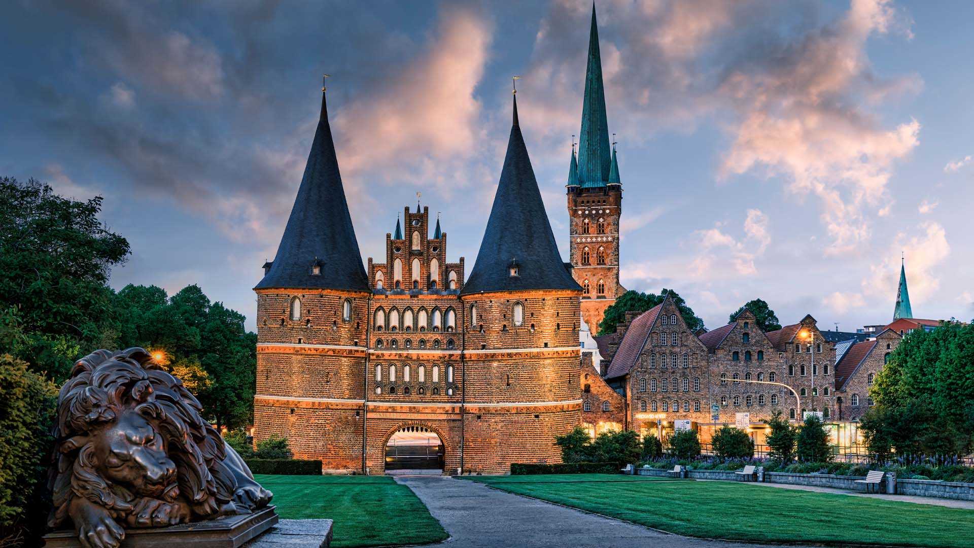
霍尔斯滕门,吕贝克,德国
霍尔斯滕门是一座城门,标志着汉萨同盟城市吕贝克旧中心的西部边界。
砖砌哥特式建筑建于1464年,是吕贝克中世纪城市防御工事的遗迹之一,也是现存的两座城门之一,另一座是城堡门 (Burgtor)。
它以其两个圆形的塔楼和拱形入口而闻名,今天被视为这座城市的象征。
1950年,Holsten Gate 再次成为博物馆,这次是为了展示市政历史。 展示了历史悠久的吕贝克遗物,以模型和图片展示了中世纪吕贝克的发展,展示了汉萨同盟舰船模型和旗舰“吕贝克之鹰”。
Holsten Gate, Lübeck, Germany
The Holsten Gate is a city gate marking off the western boundary of the old center of the Hanseatic city of Lübeck. Built-in 1464, the Brick Gothic construction is one of the relics of Lübeck's medieval city fortifications and one of two remaining city gates, the other being the Citadel Gate (Burgtor). Known for its two-round towers and arched entrance, it is regarded today as a symbol of the city.
In 1950 the Holsten Gate was again a museum, this time for municipal history. Relics from historic Lübeck were presented, the development of medieval Lübeck was shown by using models and pictures, and models of the ships of the Hanseatic League and the flagship "Eagle of Lübeck" were exhibited.
菲希特尔山脉上的和平钟,萨克森州,德国 Peace bell on the summit of Fichtelberg, Saxony, Germany (© Jan Drahokoupil/Getty Images)
菲希特尔山脉上的和平钟,萨克森州,德国 Peace bell on the summit of Fichtelberg, Saxony, Germany (© Jan Drahokoupil/Getty Images)
和平之钟 A bell for peace
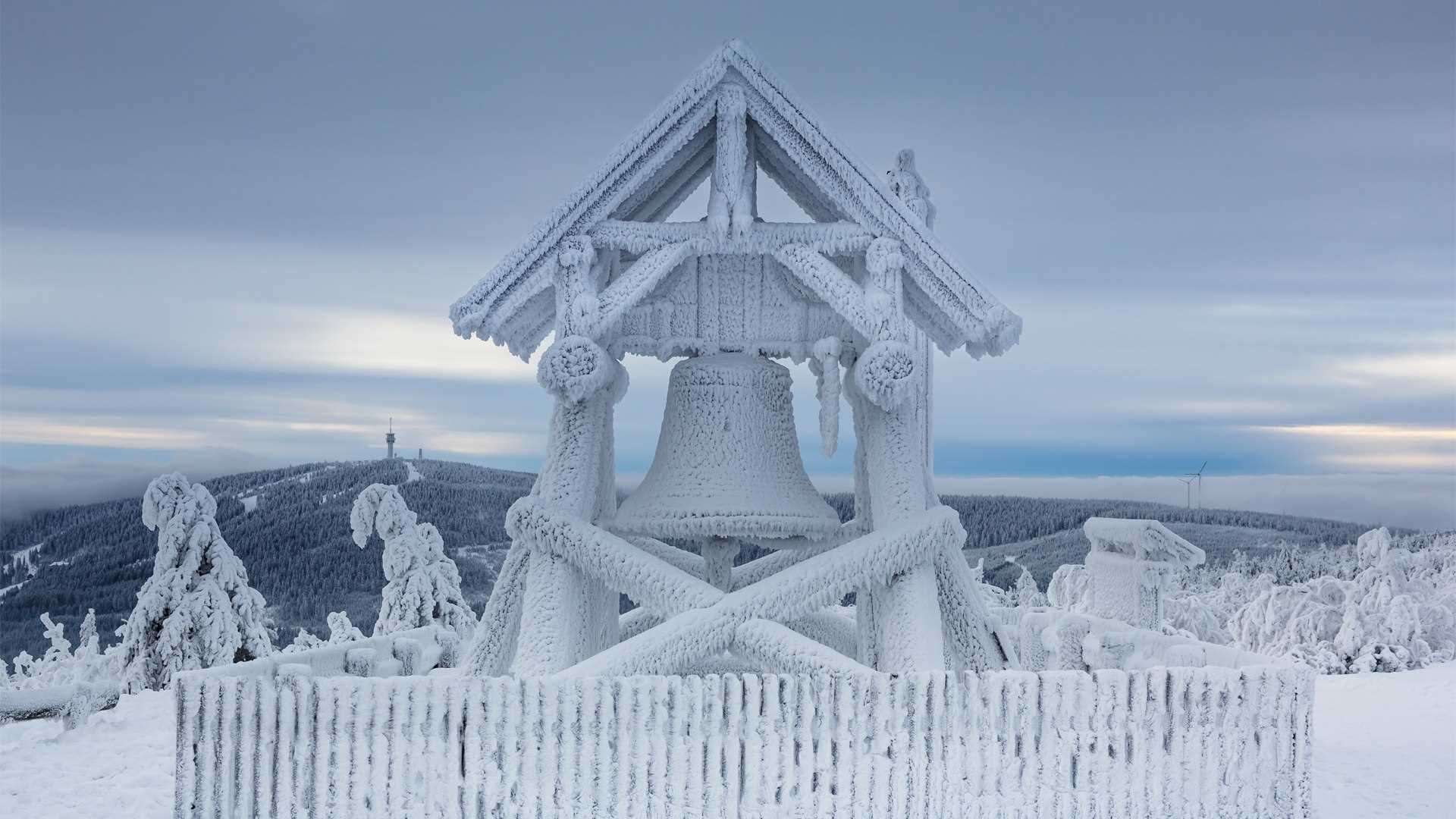
菲希特尔山脉,德国萨克森州
菲希特尔山位于厄尔士山脉的上维森塔尔镇附近。这座山高1214米,是东德最高的山峰,也是冬季运动爱好者的圣地。这里有各种冬季运动,双板滑雪、单板滑雪、越野滑雪、雪橇雪橇和马拉雪橇等等。如果你更喜欢夏天,也可以在这里来场夏日旅行,体验这里的自然风景。在菲希特尔山顶有一座和平钟,在这里欣赏到周围群山的壮丽景色。
Peace bell on Fichtelberg, Germany
The Fichtelberg is located on the Oberwiesenthal in the Ore Mountains. This mountain is 1214 m high, making it not only the highest mountain in East Germany but also a very prestigious place for winter sports enthusiasts. All kinds of sports are offered. From classic skiing and snowboarding to cross-country skiing, cross-country skiing tours, tobogganing, and horse-drawn sleigh rides. If you prefer summer, you can also enjoy this place in the warm season and completely immerse yourself in untouched nature. At the top of the mountain, you can visit the Fichtelberghaus. From there you have a breathtaking view of the surrounding mountains.
霍亨索伦城堡,德国 Hohenzollern Castle, Germany (© Sahara Prince/Shutterstock)
霍亨索伦城堡,德国 Hohenzollern Castle, Germany (© Sahara Prince/Shutterstock)
正如童话一般 Fit for a fairytale
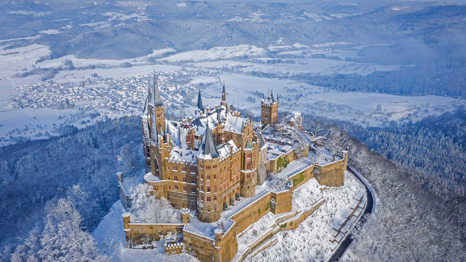
德国斯图加特附近的霍亨索伦城堡
迷人的霍亨索伦城堡经过三次重建后,是真的魅力非凡。这座城堡位于霍亨索伦山顶,修建于11世纪,但大部分建筑在1423年长达10个月的围攻中被摧毁,直到几十年后才得以重建。之后它成为了一个重要的战略据点,然而后来它再次失修。19世纪,普鲁士国王腓特烈·威廉四世(他因在德国各地建造了许多伟大的建筑而闻名)在这里建造了一座新的城堡,几乎完全替换了这座城堡15世纪的建筑结构。如今,霍亨索伦城堡已成为一座露天博物馆,每年接待超过35万名游客,是德国参观人数最多的城堡之一。
Hohenzollern Castle near Stuttgart, Germany
For the charming Hohenzollern Castle, the third time really was the charm. Constructed on the top of Hohenzollern Mountain in the 11th century, the castle was largely ruined by a 10-month siege in 1423, only to be rebuilt a few decades later. It then served as an important strategic stronghold before again falling into disrepair. In the 19th century, King Frederick William IV of Prussia, best remembered for his commitment to building great works across Germany, had a new castle built on the grounds, replacing almost all the 15th-century construction. Today, Hohenzollern Castle is an open-air museum that hosts more than 350,000 visitors per year, making it one of the most-visited castles in Germany.
泰根塞山脉Roßstein山顶的景色,德国巴伐利亚州 View from the summit of Roßstein mountain, Bavaria, Germany (© Christian Bäck/eStock Photo)
泰根塞山脉Roßstein山顶的景色,德国巴伐利亚州 View from the summit of Roßstein mountain, Bavaria, Germany (© Christian Bäck/eStock Photo)
国际山岳日 International Mountain Day
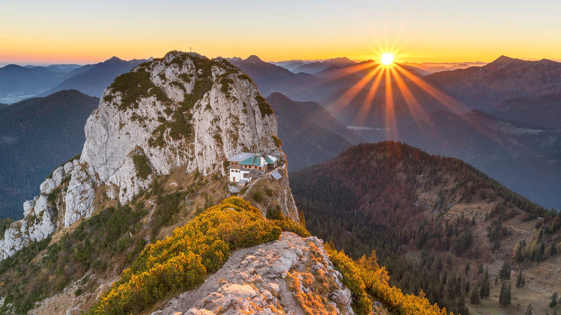
特根塞山脉
山脉是我们世界上最有趣的地质特征之一。山脉也成为无数代人类的游乐场和崇拜场所,这清楚地证明了地球表面下发生的巨大变化。几千年来,任何对如此多的人和文化如此重要的东西都值得纪念。因此,在12月11日,我们庆祝国际山地日!
我们的旅程将带我们前往位于特根塞山脉的上巴伐利亚州,这是一个属于巴伐利亚前阿尔卑斯山脉的山区。这张照片显示了从罗ß斯坦河(1698米)到布赫斯坦河(1701米)的景色。这两座山形成了一座双峰,泰格恩塞·吕特(Tegernsee Hütte)就坐落在它的马鞍上。该避难所于5月中旬至11月初开放,为徒步旅行者和登山者提供食宿。由于其暴露的位置,其位置通常被称为“鹰巢”。
Tegernsee Mountains
Mountains are some of the most interesting geological features that our world has to offer. Clear proof of the massive changes that happen beneath the surface of our planet, mountains have also served as playgrounds and places of worship for countless generations of humans. Anything that’s been such a mainstay for so many people and cultures through millennia is worth commemorating. So on December 11, we celebrate International Mountain Day!
Our excursion takes us to Upper Bavaria in the Tegernsee Mountains, a mountain region that belongs to the Bavarian Pre-Alps. The photo shows the view from the Roßstein (1,698 meters) to the Buchstein (1,701 meters). Both mountains form a double peak, in whose saddle the Tegernsee Hütte nestles. The refuge, which is open from mid-May to early November, offers board and lodging to hikers and climbers. Due to its exposed location, its location is often referred to as the "eagle's nest".
坎彭万德山,基姆高地区阿绍,德国巴伐利亚州 View from Kampenwand mountain, Aschau im Chiemgau, Bavaria, Germany (© Toni Anzenberger/plainpicture)
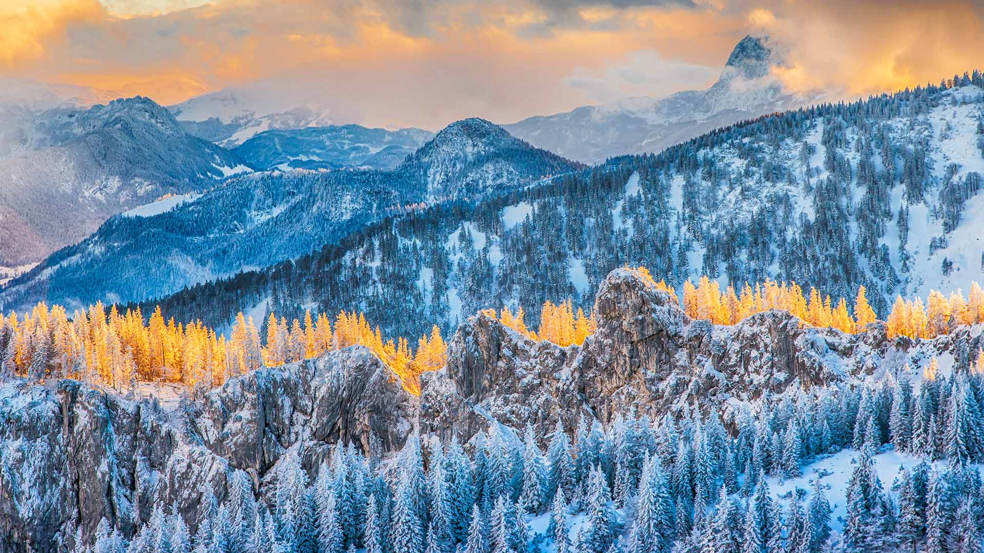
坎彭万德山,基姆高地区阿绍,德国巴伐利亚州 View from Kampenwand mountain, Aschau im Chiemgau, Bavaria, Germany (© Toni Anzenberger/plainpicture)
令人惊叹的山顶美景 Stunning mountain top view
巴伐利亚州坎本万德山
冬天已经来到了坎彭德的顶峰。在春季和夏季,许多徒步旅行者、山地自行车手、登山者、悬挂滑翔机和滑翔伞爱好者在这里嬉戏,在寒冷的季节,一点平静逐渐回归。现在,该地区正成为雪鞋徒步旅行者和滑雪旅游者的吸引力。
根据观看方向的不同,您可以欣赏坎彭德的壮丽全景。阿尔卑斯山麓和基姆山脉向北延伸,在晴朗的日子,你甚至可以看到西北部的慕尼黑电视塔。在南部-如这张照片中所示-可以看到巴伐利亚和奥地利山脉的独特景色。
Kampenwand mountain, Bavaria
Winter has already arrived at the summit of the Kampenwand. Where numerous hikers, mountain bikers, and climbers as well as hang-gliders, and paragliders cavort in spring and summer, a little calm gradually returns in the cold season. Now the region is becoming an attractive attraction for snowshoe hikers and touring skiers.
Depending on the viewing direction, you can enjoy a magnificent panorama from the Kampenwand. The foothills of the Alps with the Chiemsee stretch northwards, and on a clear day, you can even spot Munich's television tower in the northwest. In the south - as in this photo - there is a unique view of the Bavarian and Austrian mountains.