金门大桥和马林岬角,美国加利福尼亚州 Golden Gate Bridge and Marin Headlands photographed from Golden Gate Overlook in San Francisco, California (© Jeff Lewis/Tandem Stills + Motion)
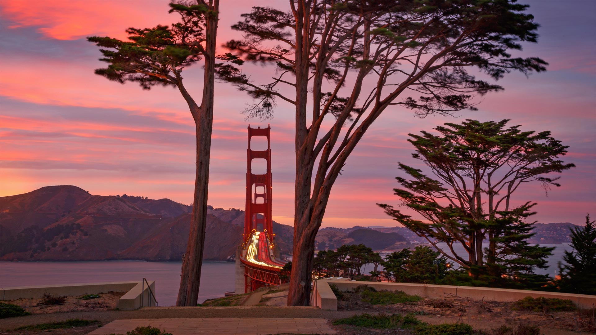
金门大桥和马林岬角,美国加利福尼亚州 Golden Gate Bridge and Marin Headlands photographed from Golden Gate Overlook in San Francisco, California (© Jeff Lewis/Tandem Stills + Motion)
没有哪儿比这里更能代表旧金山… Nothing says 'San Francisco' quite like...
Golden Gate Bridge, San Francisco
Few structures achieve the status of the Golden Gate Bridge—so recognizable that it needs no introduction. Opened on this day in 1937, the bridge was a marvel of engineering, built to withstand ferocious winds above and swirling currents below. Its construction was embraced by the local population because it would finally connect the rising metropolis of San Francisco to communities in Marin County and all that lay north. Before the bridge was completed, a ferry was the only way across the Golden Gate, the mile-wide strait that connects the Pacific Ocean to San Francisco Bay. Building a bridge to cross the span would be no small feat, and many thought it impossible.
Financing for the construction was another hurtle and was put further at risk with the Great Crash of 1929. But eventually voters in the Bay Area supported a bond measure worth $35 million ($473 million today), using their homes, farms, and business properties as collateral—the infusion of cash allowed construction to begin in 1933. In the midst of the Great Depression, the bridge became a jobs generator, putting 2,000 men to work. In four years they completed the engineering triumph ahead of schedule and under budget.
Its two towers rise to 755 feet above the water, and the span suspended between them is 4,200 feet long, which made it the longest suspension bridge in the world upon its completion. Seventeen longer suspension bridges have since been built (most of them in China), but the Golden Gate remains the star among them, considered the most beautiful, most photographed, a symbol of American style and ingenuity, and a calling card for a city. There are few better reasons to leave your heart in San Francisco.
旧金山金门大桥
很少有建筑能达到金门大桥的地位,因此不需要引入。这座桥于1937年的今天开通,是一座工程奇迹,它的建造可以抵御上方的狂风和下方的涡流。它的建设受到了当地居民的欢迎,因为它最终将连接旧金山这座正在崛起的大都市与马林县以及所有北部地区的社区。在大桥建成之前,渡船是穿越金门的唯一途径,金门是连接太平洋和旧金山湾的一英里宽的海峡。建造一座横跨这座桥将是一项不小的壮举,许多人认为这是不可能的。
建筑融资是另一个突如其来的问题,1929年的大崩盘使其面临更大的风险。但最终,海湾地区的选民支持一项价值3500万美元(今天为4.73亿美元)的债券措施,将他们的房屋、农场和商业地产作为抵押品。1933年,注入的现金使建设得以开始。在大萧条期间,这座桥创造了就业机会,使2000人就业。在四年内,他们在预算内提前完成了工程胜利。
它的两座塔楼高出水面755英尺,两座塔楼之间的跨度为4200英尺,建成后成为世界上最长的悬索桥。自那以后,已经建造了17座更长的吊桥(大部分在中国),但金门仍然是其中的明星,被认为是最美丽、拍照最多的吊桥,是美国风格和创造力的象征,也是城市的名片。没有什么更好的理由可以把你的心留在旧金山。
巨型红杉的小萌芽,加利福尼亚州 A young giant sequoia sprouting out of an old log in Prairie Creek Redwoods State Park, California (© Hutch Axilrod/Getty Images)
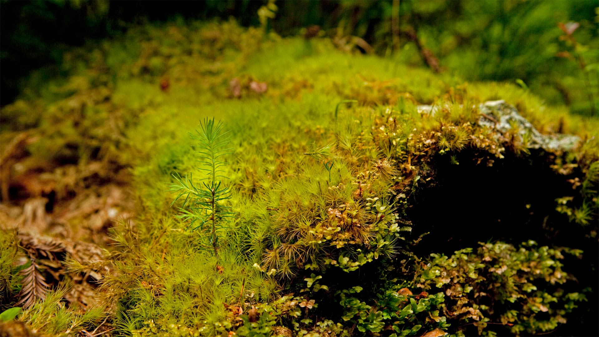
巨型红杉的小萌芽,加利福尼亚州 A young giant sequoia sprouting out of an old log in Prairie Creek Redwoods State Park, California (© Hutch Axilrod/Getty Images)
潜力惊人的萌芽 The sprout with amazing potential
Arbor Day
With a little love and support, this little sprout at Prairie Creek Redwoods State Park in California has a big future ahead of it. It has the potential to one day be the tallest tree on the planet, or at least close to it. Its 'big brother,' Hyperion, currently holds the record at 380 feet. They're giant sequoias, aka giant redwood trees. They often grow upwards of 300 feet tall and can live for thousands of years. They're heroes of nature, affecting the weather and climate, while housing and protecting other plants and animals. But all of this little sprout's potential is at risk because the giant sequoia is an endangered species. Fewer than 80,000 of them remain. That's why today is an important day for it and all trees.
That's right, today is Arbor Day, the day where we stop a moment to think about the trees (and hopefully even plant a few). The first American Arbor Day occurred 150 years ago when an estimated one million trees were planted in Nebraska in 1872. This year, America's Arbor Day Foundation is celebrating its 50th year of dedication to tree planting. They've planted over 350 million of them over the years, but the mission never ends. Trees are vital to the health of our planet, which means they're important for our own health as well. Why not do a little to make the future a better place and take a moment to nurture or plant a new tree today?
植树节
有了一点爱和支持,加利福尼亚州大草原溪红杉州立公园的这棵小豆芽就有了一个广阔的未来。它有可能有一天成为地球上最高的树,或者至少离它很近。它的“老大哥”海伯龙目前保持着380英尺的纪录。它们是巨大的红杉,又名巨大的红杉。它们通常能长到300英尺高,可以存活数千年。他们是大自然的英雄,影响天气和气候,同时居住和保护其他动植物。但由于巨型红杉是一种濒危物种,这种小豆芽的所有潜力都面临风险。剩下的不到8万人。这就是为什么今天对它和所有树木来说都是重要的一天。
没错,今天是植树节,这一天我们会停下来想一想那些树(希望还能种一些)。美国第一个植树节发生在150年前,1872年内布拉斯加州种植了大约100万棵树。今年,美国植树节基金会将庆祝植树50周年。多年来,他们已经种植了超过3.5亿株,但任务从未结束。树木对我们星球的健康至关重要,这意味着它们对我们自身的健康也很重要。为什么不做一点事情,让未来变得更好,今天花点时间培育或种植一棵新树呢?
半穹顶景观点上空的银河,优胜美地国家公园,加利福尼亚州 Milky Way rising above Half Dome in Yosemite National Park, California (© Cory Marshall/Tandem Stills + Motion)
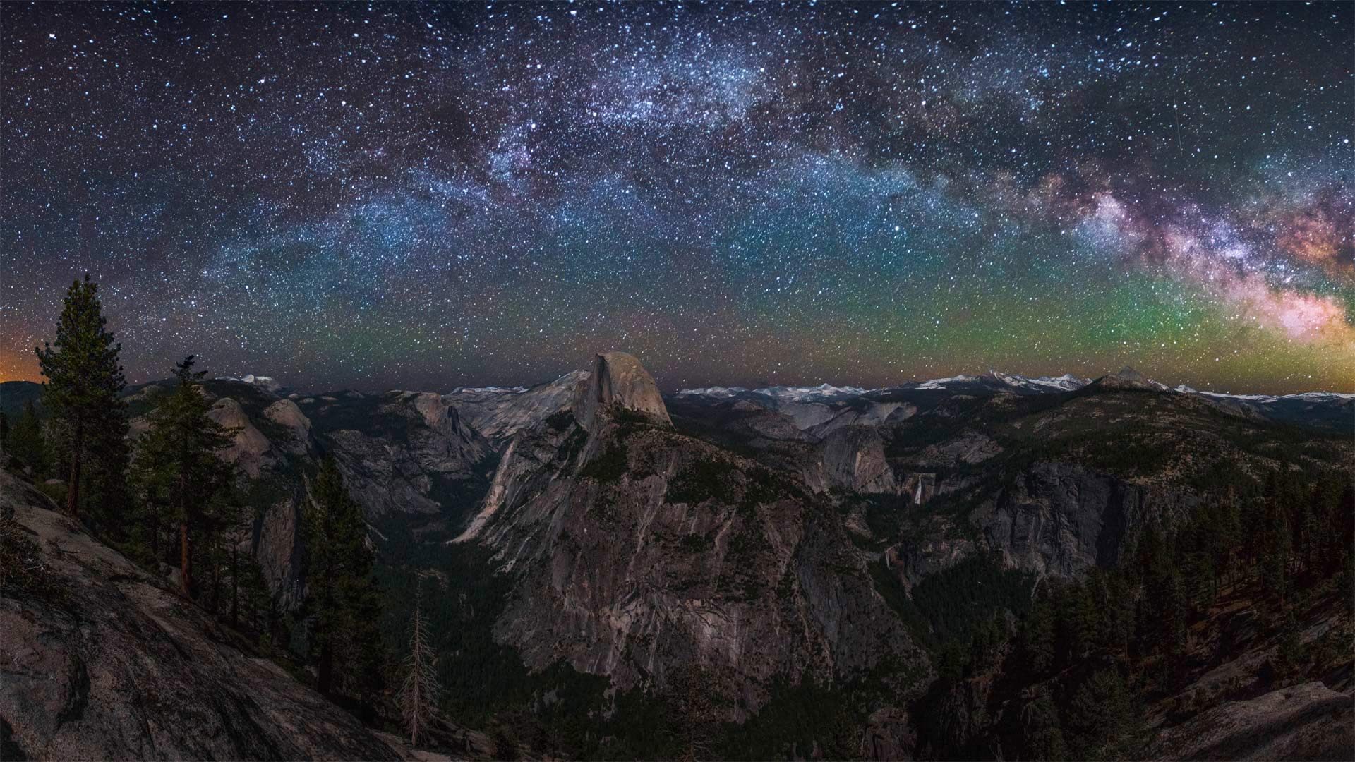
半穹顶景观点上空的银河,优胜美地国家公园,加利福尼亚州 Milky Way rising above Half Dome in Yosemite National Park, California (© Cory Marshall/Tandem Stills + Motion)
你能把灯关掉吗? Could you turn off the lights?
Dark Sky Week
During International Dark Sky Week, we're counting ourselves lucky to have this spectacular nighttime view, considering the astonishing fact that 83% of the global population lives under a light-polluted sky. Unneeded artificial light is classified as a pollutant and has been proven to have harmful side effects. Not only does it waste money and energy, it also disrupts plants and animals, is believed to impact the climate, and blocks our view of the universe.
Encouraging people to get away from artificial light is one of the goals of International Dark Sky Week, and today's photo shows just how magnificent that can be. Here, we're treated to a beautiful view of the Milky Way from Yosemite National Park in California. Yosemite is part of a network of national parks monitoring dark night skies to gather a complete data set of light pollution. They've learned that 'two-thirds of Americans cannot see the Milky Way from their backyard, and if current light pollution trends continue, there will be almost no dark skies left in the contiguous United States by 2025.'
Luckily, dark sky is a recoverable resource. There are ways to reduce our light use and improve the view of the night sky for everyone. Think about it over the course of the next week, preferably while gazing at a night sky undisturbed by light pollution—or at least a beautiful photo of one.
黑暗天空周
在国际黑暗天空周期间,考虑到全球83%的人口生活在轻度污染的天空下这一令人震惊的事实,我们认为自己有幸拥有这一壮观的夜景。不需要的人造光被归类为污染物,并已被证明具有有害的副作用。它不仅浪费金钱和能源,还扰乱动植物,被认为会影响气候,阻碍我们对宇宙的看法。
鼓励人们远离人造光是国际黑暗天空周的目标之一,今天的照片展示了这是多么壮观。在这里,我们可以在加利福尼亚州约塞米蒂国家公园欣赏到银河系的美景。约塞米蒂是国家公园网络的一部分,该网络监测黑夜天空,以收集光污染的完整数据集。他们了解到,“三分之二的美国人无法从自家后院看到银河系,如果目前的光污染趋势继续下去,到2025年,毗邻的美国将几乎没有黑暗的天空。”
幸运的是,黑暗的天空是一种可回收的资源。有一些方法可以减少我们的光线使用,改善每个人的夜空视野。在接下来的一周里好好想想,最好是在凝视没有光污染的夜空时,或者至少是一张美丽的照片。
雷斯岬国家海岸公园里的柏树隧道,美国加利福尼亚州 The cypress tunnel at Point Reyes National Seashore in California (© Spondylolithesis/Getty Images)
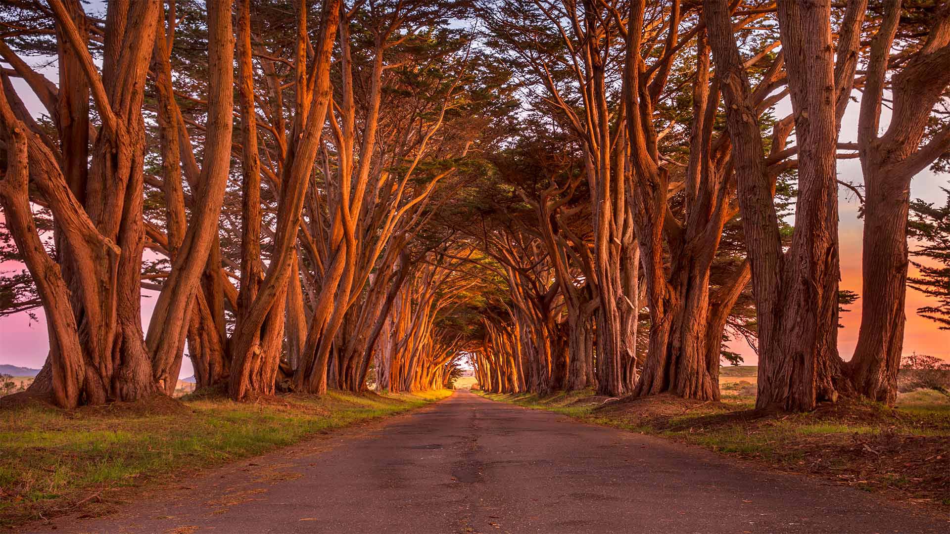
雷斯岬国家海岸公园里的柏树隧道,美国加利福尼亚州 The cypress tunnel at Point Reyes National Seashore in California (© Spondylolithesis/Getty Images)
通往过去的隧道 A tunnel to the past
Point Reyes National Seashore
This evocative photo of a cypress-lined road was taken in Point Reyes National Seashore, a marine and coastal reserve under the care of the National Park Service. A portion of the park preserves the marine habitat in the harbors along the coast of the Point Reyes Peninsula on California's central coast. Inland, the area's grasslands, marshlands, and wooded uplands present a notably diverse collection of landscapes—including the cypress tunnel.
It's worth noting that at the end of this tree-lined cul-de-sac is an old ship-to-shore radio station known as KPH. It's mostly a historic site that still broadcasts locally but was once a vital communications relay for the many ships that passed by Point Reyes, especially during World War II.
雷耶斯角国家海岸酒店
这张令人想起的柏树林立的道路照片是在雷耶斯角国家海岸拍摄的,这是一个由国家公园管理局管理的海洋和海岸保护区。公园的一部分保留了加州中央海岸雷耶斯角半岛沿岸港口的海洋栖息地。在内陆地区,该地区的草原、沼泽地和树木繁茂的高地呈现出明显多样的景观,包括柏树隧道。
值得注意的是,在这条绿树成荫的死胡同的尽头,有一个名为KPH的老式船对岸电台。它主要是一个历史遗址,仍然在当地广播,但曾经是许多经过雷耶斯角的船只的重要通信中继,尤其是在第二次世界大战期间。
安沙波利哥沙漠州立公园,美国加利福尼亚州 Borrego Badlands in Anza-Borrego Desert State Park, California (© Tom Hogan/plainpicture)
安沙波利哥沙漠州立公园,美国加利福尼亚州 Borrego Badlands in Anza-Borrego Desert State Park, California (© Tom Hogan/plainpicture)
Borrego Badlands
If you're looking to take in a beautiful sunset over some exotic terrain, you could do worse than the Borrego Badlands, a 20-mile stretch of desert in southeastern California's Anza-Borrego Desert State Park. This arid landscape is not the kind of dune-filled terrain t you might visualize when you think of a desert, but a series of rolling hills, canyons, gullies, and arroyos, speckled with sparse but hardy vegetation. It makes for a surreal and beautiful view.
Fossilized seashells found in the area reveal that this arid landscape was once submerged under the waters of the Gulf of California and the Colorado River. The terrain was shaped over time by water and wind erosion into its current form. Today, the Borrego Badlands is a favorite spot for campers, while photographers are drawn by the picture-perfect sunsets.
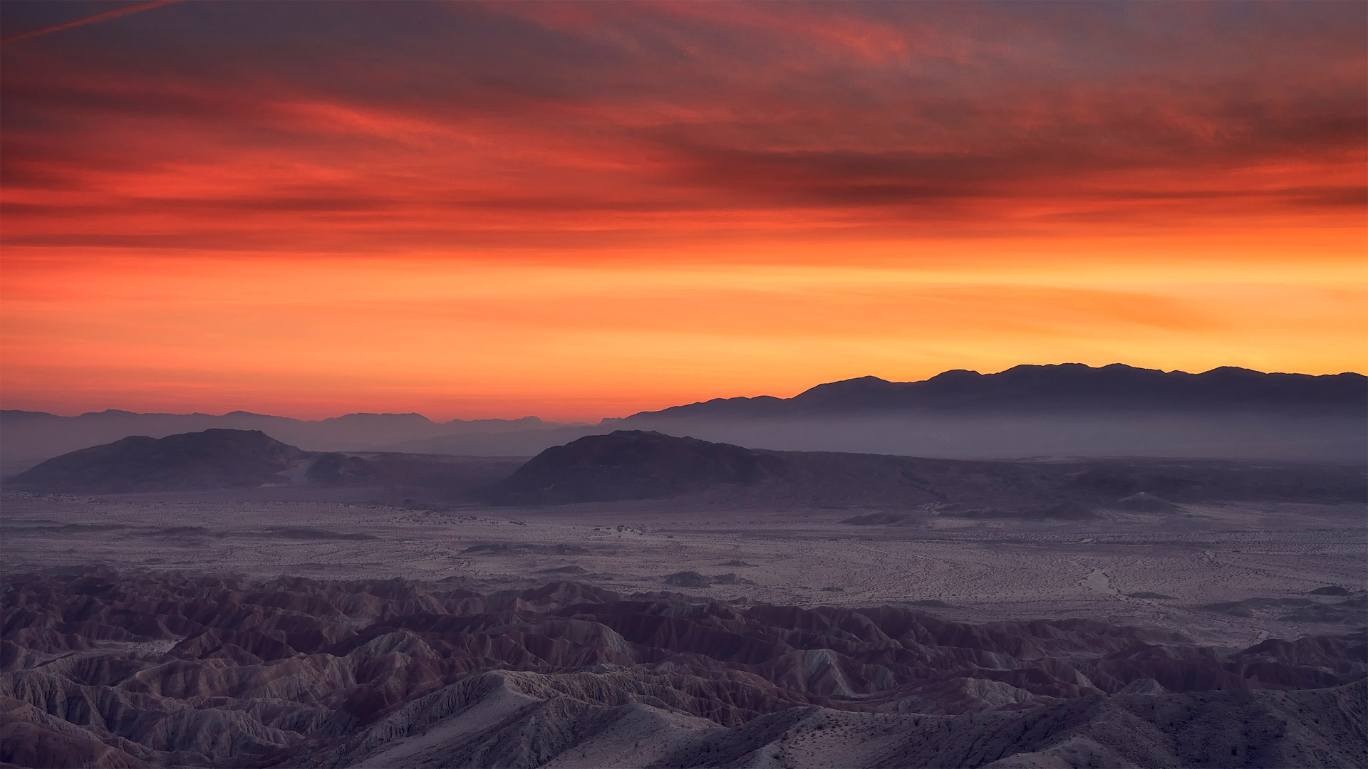
博雷戈荒地
如果你想在异国情调的地形上欣赏美丽的日落,你可能会比博雷戈荒地(Borrego Badlands)更糟糕。博雷戈荒地位于加利福尼亚州东南部的安扎博雷戈沙漠州立公园(Anza Borrego desert State Park),是一片20英里长的沙漠。这片干旱的土地并不是你想象中的那种布满沙丘的土地,而是一系列起伏的丘陵、峡谷、沟壑和荒野,点缀着稀疏但耐寒的植被。这是一个超现实主义和美丽的景色。
在该地区发现的贝壳化石表明,这片干旱的土地曾被淹没在加利福尼亚湾和科罗拉多河的水域之下。随着时间的推移,地形被水和风侵蚀成现在的形状。今天,博雷戈荒地是露营者最喜欢的地方,而摄影师则被完美的日落所吸引。
汉密尔顿山顶的利克天文台,美国加利福尼亚州 The Lick Observatory on Mount Hamilton, near San Jose, California (© Jeffrey Lewis/Tandem Stills + Motion)
汉密尔顿山顶的利克天文台,美国加利福尼亚州 The Lick Observatory on Mount Hamilton, near San Jose, California (© Jeffrey Lewis/Tandem Stills + Motion)
Lick Observatory
Shrouded in snow on the summit of Mount Hamilton, in the Diablo Range just east of San Jose, California, lies the world's first permanently occupied mountaintop observatory. Constructed between 1876 and 1887, the Lick Observatory has been the site of significant discoveries including several of Jupiter's moons and other planetary systems. It's named for American real-estate entrepreneur James Lick, who set aside $700,000 for the University of California to build a facility that would be home to a 'telescope superior to and more powerful than any telescope yet made.'
His wish came true. The 36-inch refracting telescope on Mount Hamilton was the largest that had ever been built from when it saw first light on January 3, 1888, until the construction of the 40-inch refractor at Wisconsin's Yerkes Observatory in 1897. Sadly, Lick died before his vision became a reality, but his name lives on. His body is even buried beneath the telescope, which continues to scan the skies today.
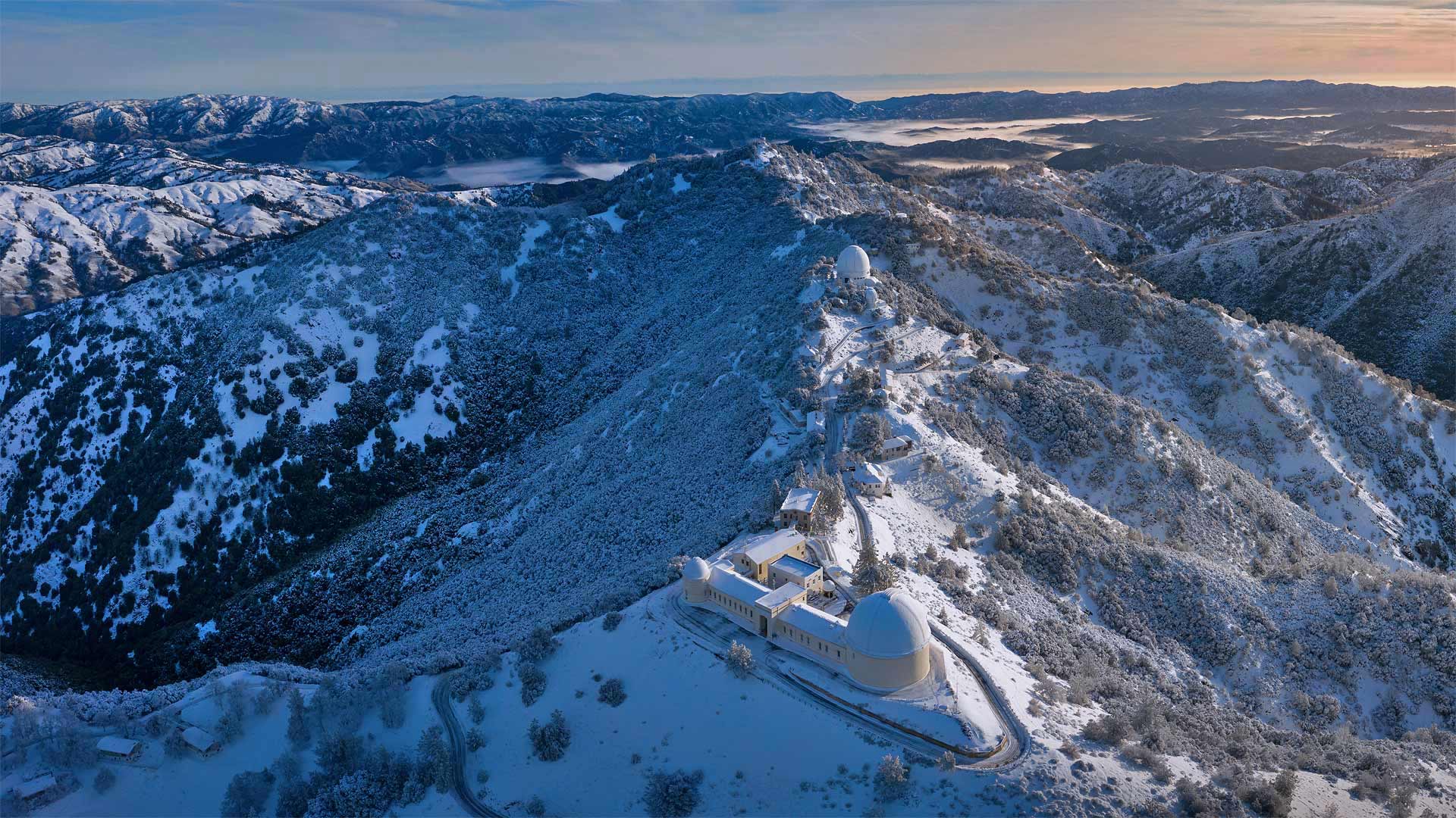
利克天文台
在加利福尼亚州圣何塞以东的暗黑破坏神山脉的汉密尔顿山顶上,积雪覆盖着世界上第一座永久性的山顶天文台。建于1876年至1887年间的利克天文台一直是重大发现的地点,其中包括一些木星卫星和其他行星系统。这是以美国房地产企业家James Lick命名的,他为加利福尼亚大学留出了700000美元建造一个设施,它将是一个比任何望远镜都更强大、更强大的望远镜。
他的愿望实现了。汉密尔顿山上的36英寸折射望远镜是从1888年1月3日第一次看到曙光到1897年威斯康星州耶克斯天文台建造40英寸折射望远镜的最大望远镜。可悲的是,利克在他的梦想变成现实之前就去世了,但他的名字却永存。他的尸体甚至被埋在望远镜下面,望远镜今天继续扫描天空。
死亡谷国家公园里的优比喜比火山口,加利福尼亚州 Ubehebe Crater in Death Valley National Park, California (© Albert Knapp/Alamy)
死亡谷国家公园里的优比喜比火山口,加利福尼亚州 Ubehebe Crater in Death Valley National Park, California (© Albert Knapp/Alamy)
When Death Valley blew its top
Deep below Death Valley's charred surface, blazing hot magma once gushed up through a geologic fault until it hit groundwater. The magma quickly turned the water to steam, and like a defective subterranean pressure cooker, the Earth's crust blew its top in a ferocious explosion. The hydrovolcanic eruption sent up a mushroom cloud of steam and spewed burnt volcanic cinders for miles. It also left the giant crater seen in this photo and 12 smaller ones spread across the surface.
The Ubehebe Crater (pronounced you-bee-HEE-bee) is a half-mile across and more than 700 feet deep. Geologically speaking, Ubehebe and the other craters here are quite young. A 2016 study concluded that the craters were all formed in a relatively brief series of explosions—a period of days or weeks—about 2,100 years ago. Another eruption could happen, but visitors need not worry about the ground below their feet—seismometers in the region will alert geologists in advance of any future volcanic unrest. A trail around the rim of the crater offers views of the colorful layers of stone along the walls. Adventurous hikers can descend to the bottom, but it's a long slog back out again, especially on a sweltering summer day.
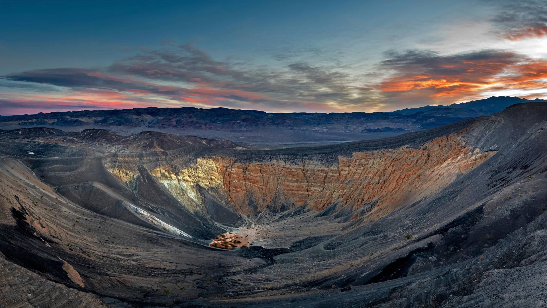
当死亡谷爆发时
在死亡谷烧焦的地表深处,炽热的岩浆曾经通过地质断层喷涌而出,直到触及地下水。岩浆很快将水变成蒸汽,就像一个有缺陷的地下压力锅,地壳在猛烈的爆炸中炸开了顶部。水火山喷发喷出蘑菇状的蒸汽云,喷出燃烧的火山灰数英里。它还留下了这张照片中看到的巨大陨石坑,12个较小的陨石坑散布在地表。
Ubehebe火山口(发音为you bee HEE bee)宽半英里,深700多英尺。从地质学的角度来说,乌贝赫比和这里的其他陨石坑都很年轻。2016年的一项研究得出结论,这些陨石坑都是在相对短暂的一系列爆炸中形成的——大约2100年前的几天或几周时间。另一次火山喷发可能会发生,但游客不必担心脚下的地面。该地区的地震仪将在未来的火山动荡之前提醒地质学家。沿着火山口边缘的小径可以看到沿着墙壁的彩色石层。喜欢冒险的徒步旅行者可以爬到水底,但要想再次爬出来还需要很长时间,尤其是在炎热的夏天。
卡里佐平原国家纪念区的野花,加利福尼亚 Wildflowers in the Carrizo Plain National Monument, California (© Dennis Frates/Alamy)
卡里佐平原国家纪念区的野花,加利福尼亚 Wildflowers in the Carrizo Plain National Monument, California (© Dennis Frates/Alamy)
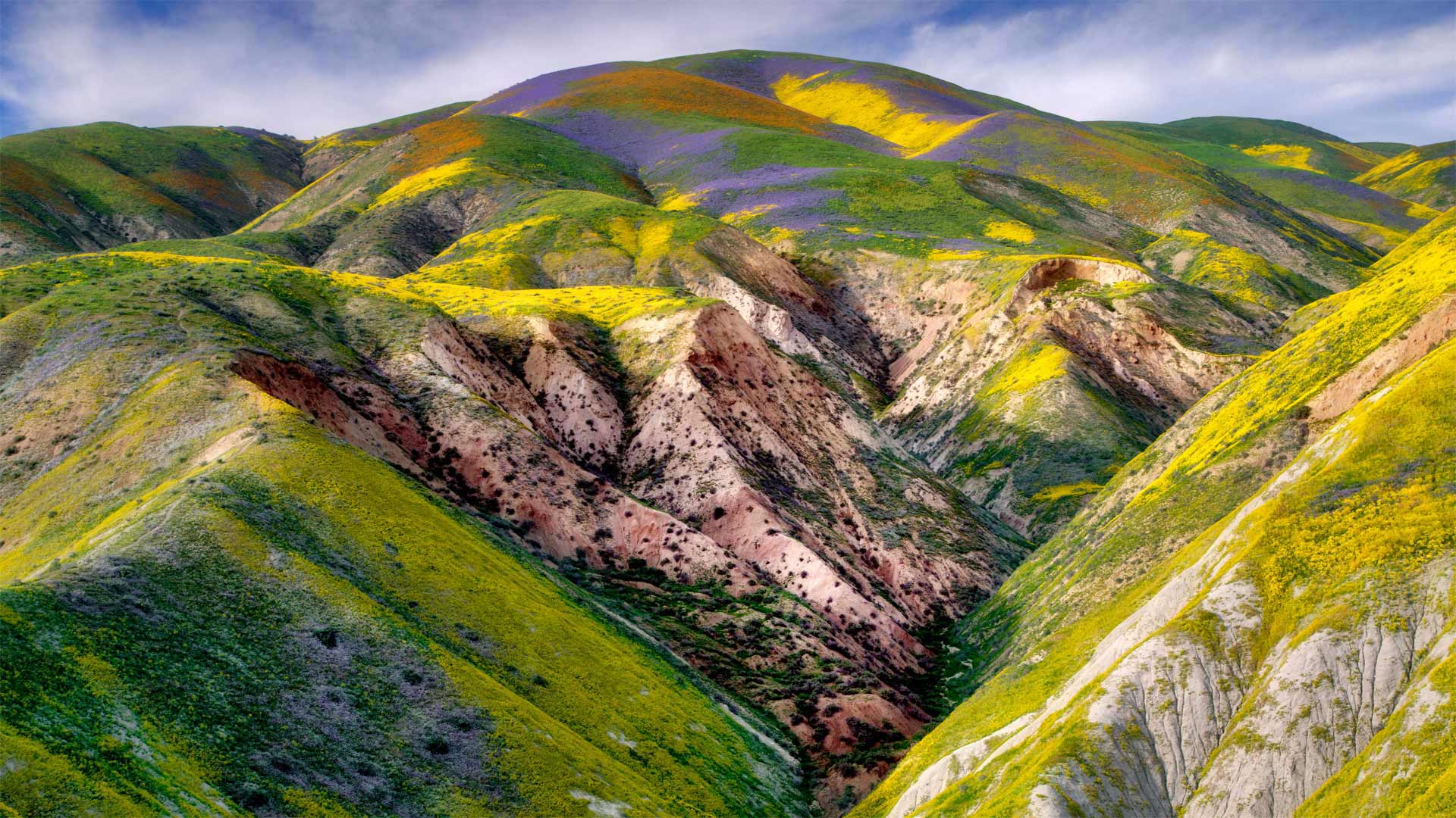
Nothing plain about it
The Carrizo Plain National Monument is a unique attraction in California—not just because of its breathtaking, colorful views, but also due to its quiet, isolated feel. Just a few hours from Los Angeles, it covers almost 250,000 acres along the base of the Temblor Mountains, giving visitors a chance to escape the crowds and experience nature. In spring, wildflowers cover the hills and valley floor, creating the amazing scene pictured here. The area also features other diverse plant species, including several listed as threatened or endangered. Wildlife includes antelope and elk, as well as rare species such as the San Joaquin kit fox, the blunt-nosed leopard lizard, and the giant kangaroo rat.
这件事没什么明显的
卡里佐平原国家纪念碑是加利福尼亚独特的景点,不仅因为它令人叹为观止、景色丰富,而且由于它安静、孤立的感觉。距离洛杉矶仅几个小时,它就覆盖了近25万英亩的TEMBLOL山脉,让游客有机会逃离人群,体验大自然。春天,山间和山谷的地面上都是野花,创造了这里的惊艳景象。该地区还拥有其他多样的植物物种,包括被列为濒危或濒危植物的几种。野生动物包括羚羊和麋鹿,以及稀有物种,如圣约金基特狐狸、钝鼻豹蜥和巨大袋鼠。
圣何塞附近的代阿布洛岭山麓,加利福尼亚 Foothills of the Diablo Range near San Jose, California (© Jeff Lewis/Tandem Stills + Motion)
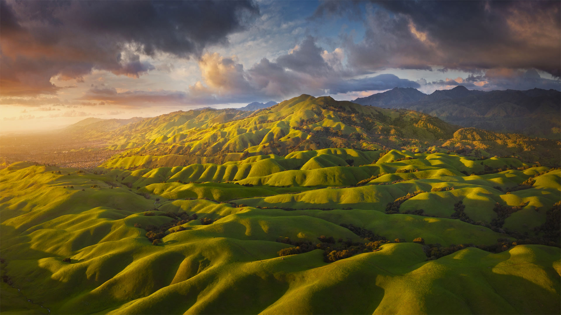
圣何塞附近的代阿布洛岭山麓,加利福尼亚 Foothills of the Diablo Range near San Jose, California (© Jeff Lewis/Tandem Stills + Motion)
Spring comes to the Diablo foothills
Spring rains carpet the rolling foothills of Northern California's Diablo Range in emerald green this time of year. Just past the sprawling suburbs of the East Bay region, the Diablo foothills become a sylvan playground for horseback riding, hiking, bicycling, and simply escaping into nature. Grasslands and oak savannahs cover the low ridges that gradually rise into the higher peaks of the range, and at the crests of the foothills, a visitor is granted panoramic views of the ridgeline to the east. Aside from the green grasses, springtime brings a profusion of wildflowers to the area, including poppies, daffodils, and lupine. It's also nesting season for the many birds of the region, like the peregrine falcons that build nests high in the vertical rock formations here known as Castle Rock.
春天来到迪亚布洛山脚下
每年的这个时候,春雨把北加州暗黑山脉的起伏山脚下铺上绿宝石。刚刚经过东湾地区广阔的郊区,Diablo山脚下变成了骑马、徒步旅行、骑自行车和逃入大自然的西尔万游乐场。草原和橡树大草原覆盖了逐渐上升到山脉较高山峰的低山脊,在山脚下的山峰上,游客可以欣赏到东边山脊线的全景。除了绿草,春天还给该地区带来了大量的野花,包括罂粟、水仙花和卢平。这里也是该地区许多鸟类筑巢的季节,就像在被称为城堡岩的垂直岩层中筑巢的猎鹰一样。
暴风雪散去,加利福尼亚优胜美地国家公园 Clearing snowstorm, Yosemite National Park, California (© Jeff Lewis/Tandem Stills + Motion)
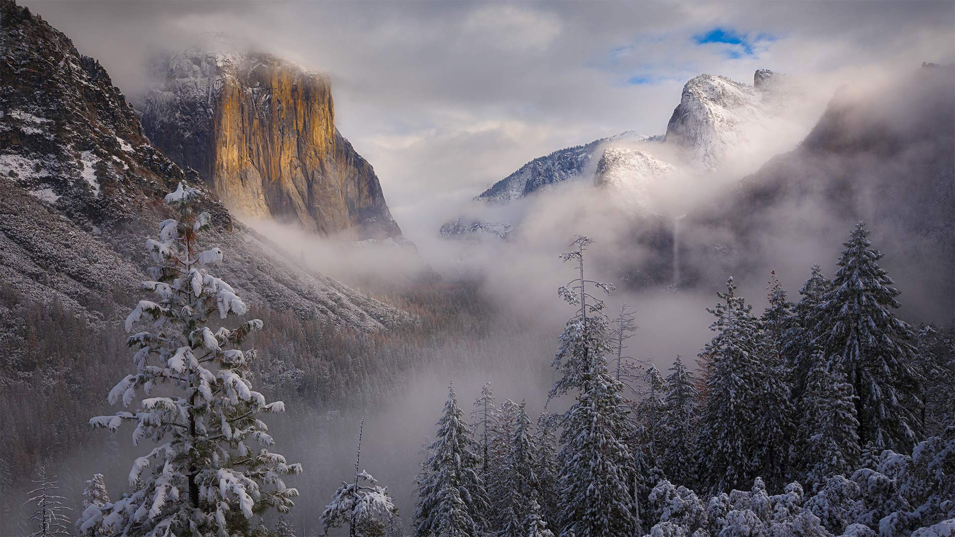
暴风雪散去,加利福尼亚优胜美地国家公园 Clearing snowstorm, Yosemite National Park, California (© Jeff Lewis/Tandem Stills + Motion)
Ansel Adams' enduring vision
Of all the camera-wielding luminaries who've snapped this eastward view of Yosemite Valley, few can hold a 'candela' to Ansel Adams, born this day in 1902. The legendary photographer of Western landscapes was given his first camera here in Yosemite as a boy. The national park was his favorite place in the world, and he returned every year for the rest of his life.
Adams' style is one of the most recognizable in photography: Bright whites against deep blacks, with high horizon lines that leave most of the frame filled with landscape, a narrow lens aperture placing every tiny detail in biting focus. Unlike many photographers of the day who considered themselves more journalist than artist, Adams was a visionary: Instead of plainly documenting what he saw, Adams aimed to convey the enchantment, awe, and terror his beloved landscapes made him feel, spending hours in the darkroom fine-tuning exposures to match what he visualized. 'Clearing Winter Storm'—the photo that today's image pays tribute to—was taken around 1937, depicting ominous clouds gathering around El Capitan and Bridalveil Fall, whiting out the distant peak of Half Dome.
While Adams had to lug bulky box cameras and light meters into the wilderness to capture his vision, chances are you've got the whole setup in your pocket. Why not grab that phone of yours, venture outside, and celebrate this legendary shutterbug's birthday with some masterful nature snaps of your own?
安塞尔·亚当斯的不朽愿景
在所有手持相机拍摄到约塞米蒂山谷东面景色的名人中,很少有人能为1902年出生的安塞尔·亚当斯(Ansel Adams)奉上“烛台”。这位西方风景的传奇摄影师小时候在约塞米蒂得到了他的第一台相机。国家公园是他在世界上最喜欢的地方,他余生每年都会回来。
亚当斯的风格是摄影界公认的最具代表性的风格之一:明亮的白色与深黑的对比,高水平的线条让大部分画面充满了风景,狭窄的镜头光圈将每一个微小的细节都置于扣人心弦的焦点。与当时许多认为自己更像记者而不是艺术家的摄影师不同,亚当斯是一个有远见的人:他没有简单地记录他所看到的一切,而是致力于传达他所钟爱的风景带给他的魅力、敬畏和恐惧,他花了数小时在暗室微调曝光,以符合他所想象的《清冬风暴》(Clearing Winter Storm)——这张今天的照片是在1937年左右拍摄的,描绘了不祥的云层聚集在埃尔卡皮坦(El Capitan)和布里达尔维尔瀑布(Bridalveil Fall)周围,使远处的半圆顶峰黯然失色。
虽然亚当斯不得不拖着笨重的盒式摄像机和测光表到荒野中捕捉他的视野,但你很可能已经把整个设置都放在口袋里了。为什么不拿起你的手机,到外面去冒险,用你自己掌握的自然快照来庆祝这个传奇的shutterbug的生日呢?