2020年7月
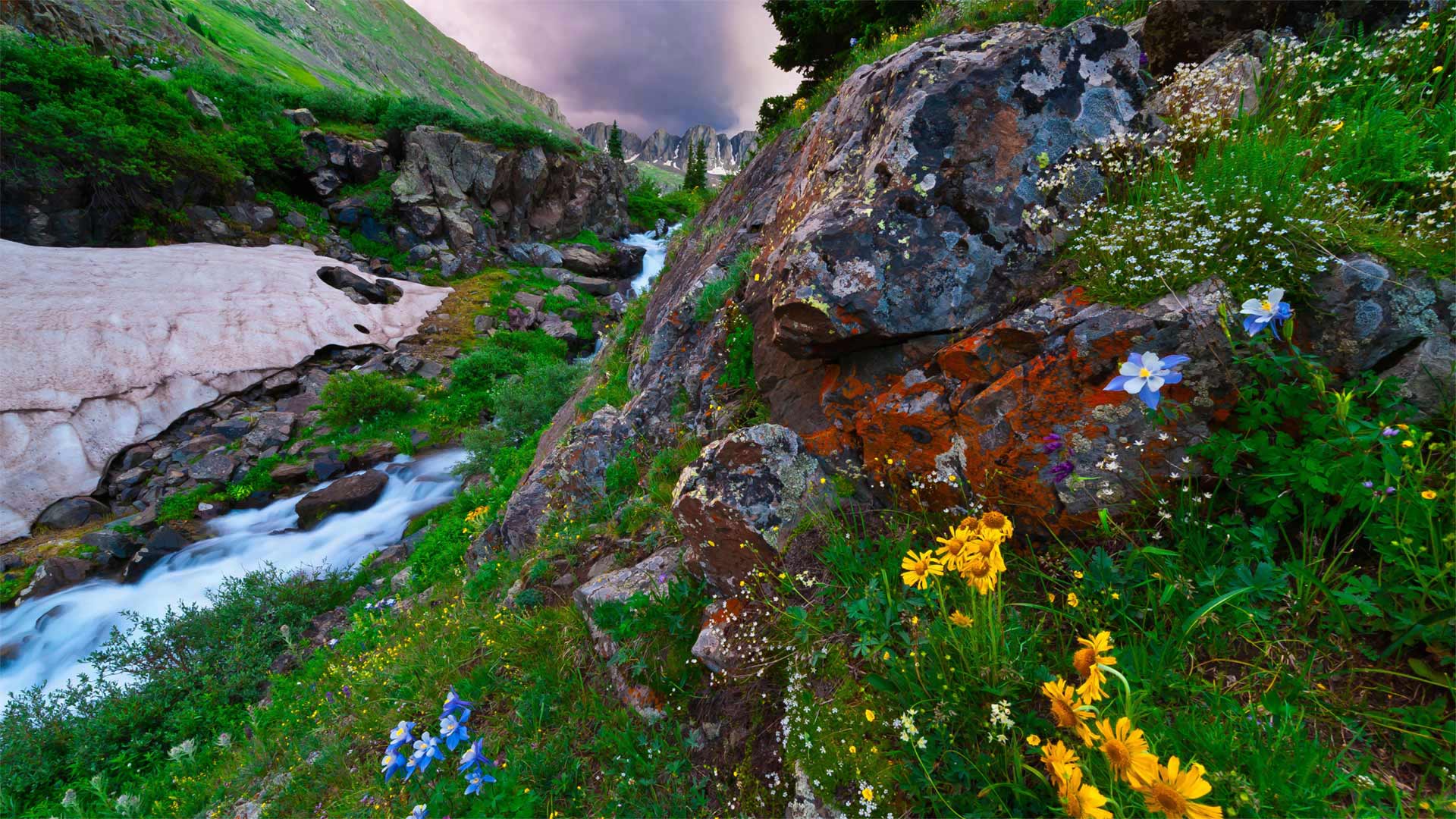
位于科罗拉多南部圣胡安山脉的美国盆地 American Basin in southern Colorado's San Juan Mountains (© Blaine Harrington III/Alamy)
位于科罗拉多南部圣胡安山脉的美国盆地 American Basin in southern Colorado's San Juan Mountains (© Blaine Harrington III/Alamy)
High alpine color in Colorado
Songstress Dolly Parton once sang 'wildflowers don't care where they grow,' but we gotta believe the wildflowers growing in Colorado's American Basin, shown here, are pretty delighted with their surroundings. American Basin is in the San Juan Mountains in the southern part of the state, about a 5-hour drive from Denver. Visitors here will find rocky cliffs, streams, unique rock formations, and some spectacular wildflowers. July and August are the best time to see the blooms—it's the time of year when you'll reliably spot the Rocky Mountain columbine (Colorado's state flower), elephant's head, Parry's primrose, and marsh marigold. Bring us back a bouquet, all right?
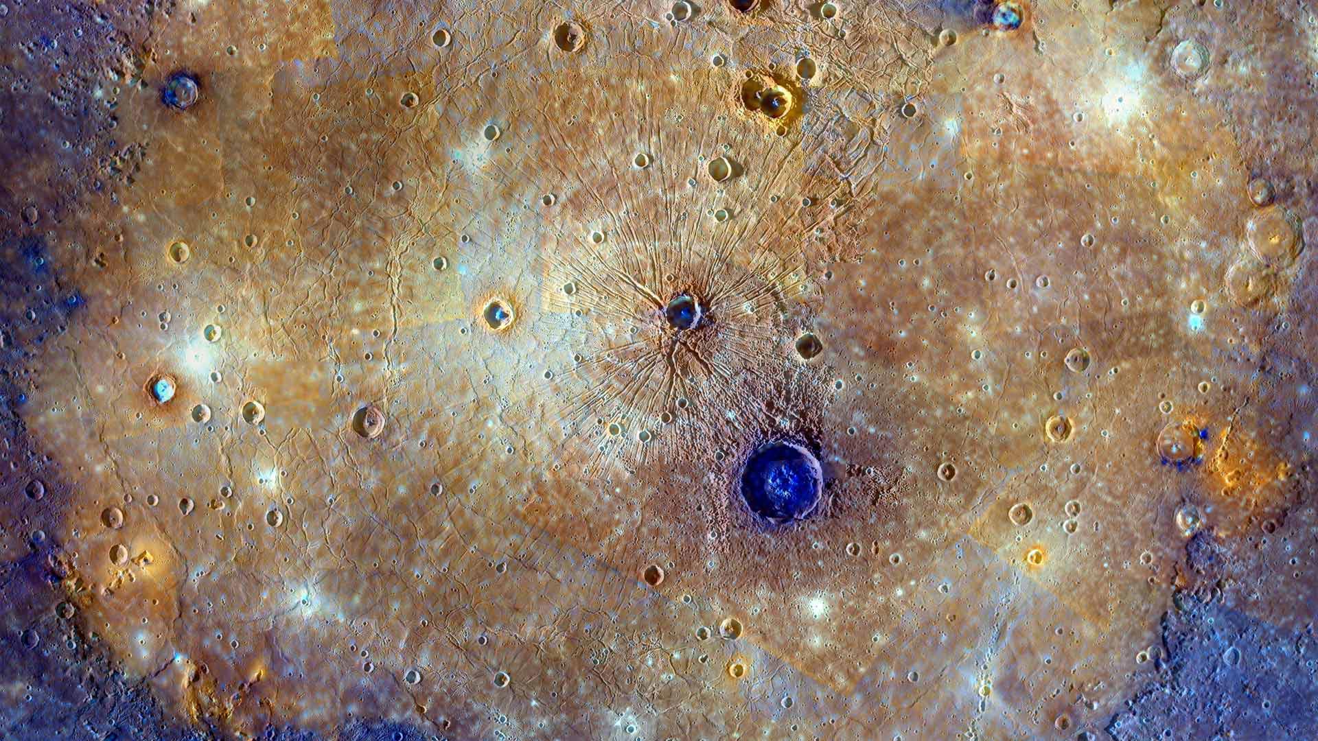
卡洛里盆地的合成全彩图,水星 Enhanced-color composite of the Caloris Basin, Mercury (© NASA/Johns Hopkins University Applied Physics Laboratory/Carnegie Institution of Washington)
卡洛里盆地的合成全彩图,水星 Enhanced-color composite of the Caloris Basin, Mercury (© NASA/Johns Hopkins University Applied Physics Laboratory/Carnegie Institution of Washington)
Mercury in retrograde
Today we're traveling to outer space to catch a glimpse of the Caloris Basin on the planet Mercury. This small planet—about the size of Earth's moon—is riddled with craters, but none as spectacular as the Caloris Basin. This large crater is about 950 miles across and is ringed by mile-high mountains.
Now, the study of space is called astronomy, and that's generally our focus when we feature stars, planets, and galaxies on the Bing homepage. But according to those who practice astrology, you may have been noticing an uptick in confusion or a spate of misfortune lately. Astrologers will tell you that 'Mercury retrograde' could be the culprit. Lasting through July 12, this is one of three times each year that Mercury appears to be traveling backwards—or what's sometimes called Mercury retrograde. This happens due to an optical illusion caused by differences in Earth's orbit relative to Mercury's. Because Mercury is named after the Roman's Messenger of the Gods, astrology associates the planet with communication. Accordingly, during Mercury retrograde, the astrologically inclined expect misunderstandings, scheduling problems, and disagreements to abound.
堪察加半岛上的扎尔巴奇克火山,俄罗斯 Tolbachik volcanic complex on the Kamchatka Peninsula, Russia (© Egor Vlasov/Shutterstock)
堪察加半岛上的扎尔巴奇克火山,俄罗斯 Tolbachik volcanic complex on the Kamchatka Peninsula, Russia (© Egor Vlasov/Shutterstock)
Welcome to the Ring of Fire
Today we're visiting the pair of volcanoes known as Tolbachik—the flat-topped Plosky (Flat) Tolbachik on the left of our image, and the majestic Ostry (Sharp) Tolbachik on the right, which soars 12,080 feet above the Kamchatka Peninsula in far eastern Russia. These are just two of approximately 160 volcanoes that dot the region; 29 of them, including the Tolbachik complex, are still active. In fact, there is so much volcanic activity here that UNESCO calls the peninsula 'one of the most outstanding volcanic regions in the world,' and has designated it a World Heritage Site.
The Kamchatka Peninsula juts out from the Russian mainland between the Sea of Okhotsk to the east and the Pacific Ocean and Bering Sea to the west. The sparsely populated peninsula makes up the western edge of the Ring of Fire, a chain of volcanoes along the Pacific Ocean that account for 90% of the world's seismic activity. Wild, remote, and primal, Kamchatka is home to an abundance of wildlife: arctic fox, tundra wolves, reindeer, lynx, huge Chukotka moose, and the Kamchatka brown bear that can tip the scales at 1,400 pounds.
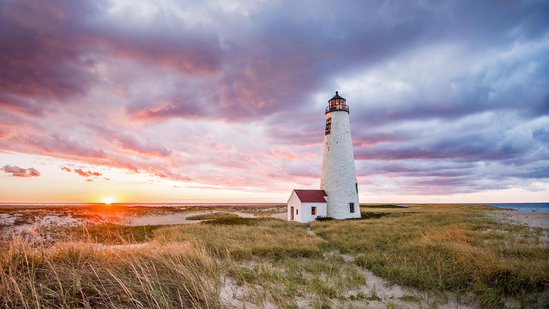
楠塔基特岛大点灯塔,麻萨诸塞州 Great Point Light on Nantucket Island, Massachusetts (© Cate Brown/Cavan Images)
楠塔基特岛大点灯塔,麻萨诸塞州 Great Point Light on Nantucket Island, Massachusetts (© Cate Brown/Cavan Images)
There once was a lighthouse from...
Nantucket is the island home of about 12,000 people. But venture to its sandy northern reaches, composed of narrow sand spits and only accessible via 4x4 vehicles, and you might not bump into many folks on your way to this historic—and still very important—lighthouse.
The Great Point Light on the island's northernmost tip traces its origin to 1784, a time when Nantucket was world famous—not so much for appearing in countless (often bawdy) limericks, but as the epicenter of the American whaling industry. Herman Melville wrote that Nantucket whalers once controlled two-thirds of the globe's waters, and to get home, all those whaling ships had to navigate the perilous shoals between the island's north shore and nearby Cape Cod. This lighthouse was the solution, first in the form of a wooden tower that burned in 1816, then a stone version toppled by a storm in 1984. The current structure, built partly with materials from the previous one, was dedicated in 1986 and has been in official operation since.
土耳其棉花堡附近希腊古城希拉波利斯的剧院鸟瞰图 Aerial view of the theater at the ancient city of Hierapolis, adjacent to Pamukkale, Turkey (© Amazing Aerial Agency/Offset by Shutterstock)
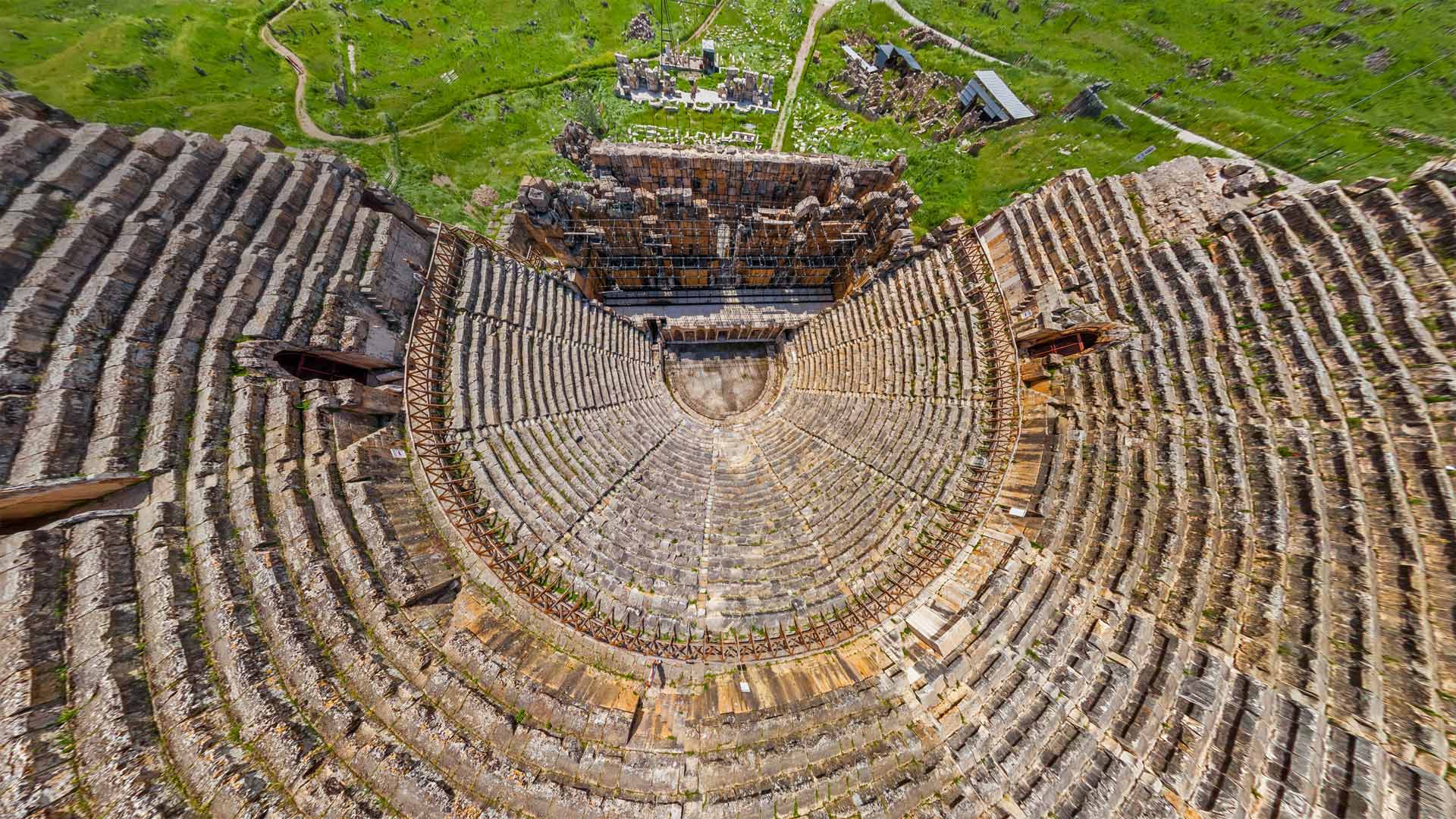
土耳其棉花堡附近希腊古城希拉波利斯的剧院鸟瞰图 Aerial view of the theater at the ancient city of Hierapolis, adjacent to Pamukkale, Turkey (© Amazing Aerial Agency/Offset by Shutterstock)
Take in a show on your Roman holiday
In the hills around Pamukkale, Turkey, you'll find the ancient ruins of Hierapolis, which thrived here as holy and healing destination through Greek, Roman, and Ottoman times. The city was founded as a thermal spa in 190 BCE by Eumenes II, the king of Pergamon and was likely named after the wife of the legendary founder of the Pergamene dynasty, Hiero.
The amphitheater so prominent in this aerial view was built in the second century CE under Roman Emperor Hadrian. Renovated several times over the next 160 years—once to accommodate aquatic shows--the theater would have seated about 15,000 people. An earthquake in 1354 finally toppled the ancient city and it was abandoned until it was excavated by German archeologist Carl Humann in the 19th century. Today, the complex retains some of the best-preserved decorative features of any ancient Roman theater, with friezes of Roman Emperor Septimus Severus and his family, as well as the Greek gods Dionysus, Artemis, and Apollo.
班夫国家公园中莫兰湖的延时视频,加拿大艾伯塔省 Time-lapse video of Moraine Lake in Banff National Park, Alberta, Canada (© Schroptschop/Getty Images)

班夫国家公园中莫兰湖的延时视频,加拿大艾伯塔省 Time-lapse video of Moraine Lake in Banff National Park, Alberta, Canada (© Schroptschop/Getty Images)
Canada's $20 view
For Canada Day, we're looking at Moraine Lake in Banff National Park. And if you're thinking that this amazing view is worth more than $20, you're right. But this priceless scene was once featured on Canada's $20 bill, hence the nickname. Canada Day, celebrated on July 1, commemorates the date in 1867 when Canada was recognized as a self-governing country under the British Empire It's not exactly Canadian Independence Day–it marks the passing of the Constitution Act of 1867, which was the first major step toward Canada's sovereignty.
Moraine Lake is just one of the many beautiful areas in Canada's oldest national park. Located in Alberta's Rocky Mountains, Banff covers more than 2,500 square miles–though we should say 6,641 square kilometres. After all, it's Canada Day.