标签 加拿大 下的文章
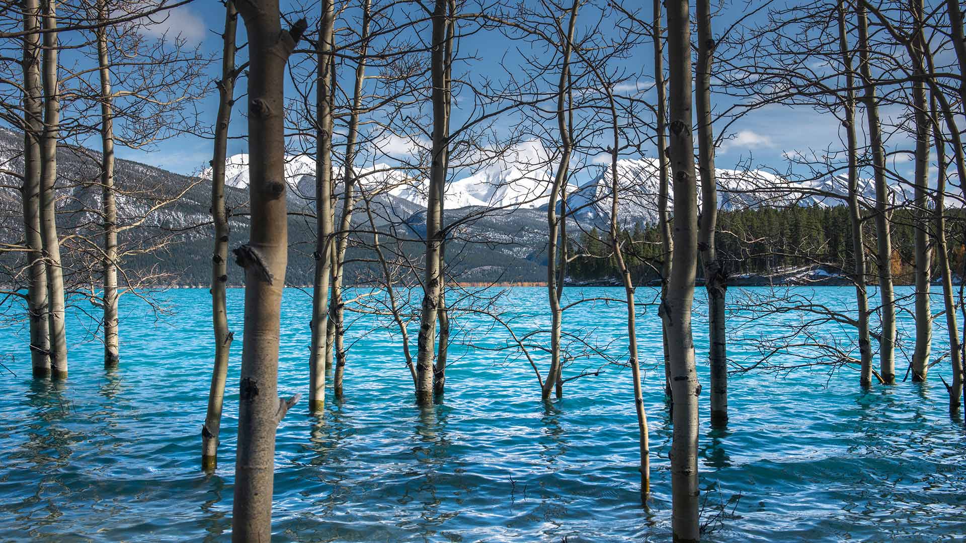
亚伯拉罕湖中的树,加拿大艾伯塔 Tree trunks in Abraham Lake, Alberta, Canada (© Coolbiere/Getty Images)
亚伯拉罕湖中的树,加拿大艾伯塔 Tree trunks in Abraham Lake, Alberta, Canada (© Coolbiere/Getty Images)
Lake and a reservoir
Today, we’re taking in views of Alberta’s largest reservoir – Abraham Lake. It was created in 1972 following the completion of the Bighorn Dam on the North Saskatchewan River. The dam was built by then Calgary Power Company, now TransAlta, to produce hydroelectric power. As seen here, Abraham Lake boasts a vivid shade of blue, further contributing to the breathtaking view with the mountains in the background. Of late, this gem in the Rockies has become a must-see for photographers every winter, for the emergence of the extraordinary frozen bubbles trapped under the lake. As the temperature drops, methane gas released from water-dwelling bacteria, forms into bubbles and freezes under the surface of the frozen lake. When the layer of ice on the lake is clear, the frozen bubbles can be seen and make for a remarkable spectacle.
湖和水库
今天,我们将欣赏艾伯塔省最大的水库——亚伯拉罕湖。它是1972年在北萨斯喀彻温河上的比格霍恩大坝完工后建造的。大坝由当时的卡尔加里电力公司(现为TransAlta)建造,用于生产水力发电。如图所示,亚伯拉罕湖拥有一个生动的蓝色阴影,进一步促进了以山脉为背景的惊险景色。最近,落基山脉的这块宝石每年冬天都成为摄影师们的必看之地,因为湖底出现了异常冰冻的气泡。随着温度下降,水中细菌释放出的甲烷气体形成气泡,冻结在结冰的湖面下。当湖面上的冰层清澈见底时,可以看到结冰的气泡,形成一种非凡的景象。
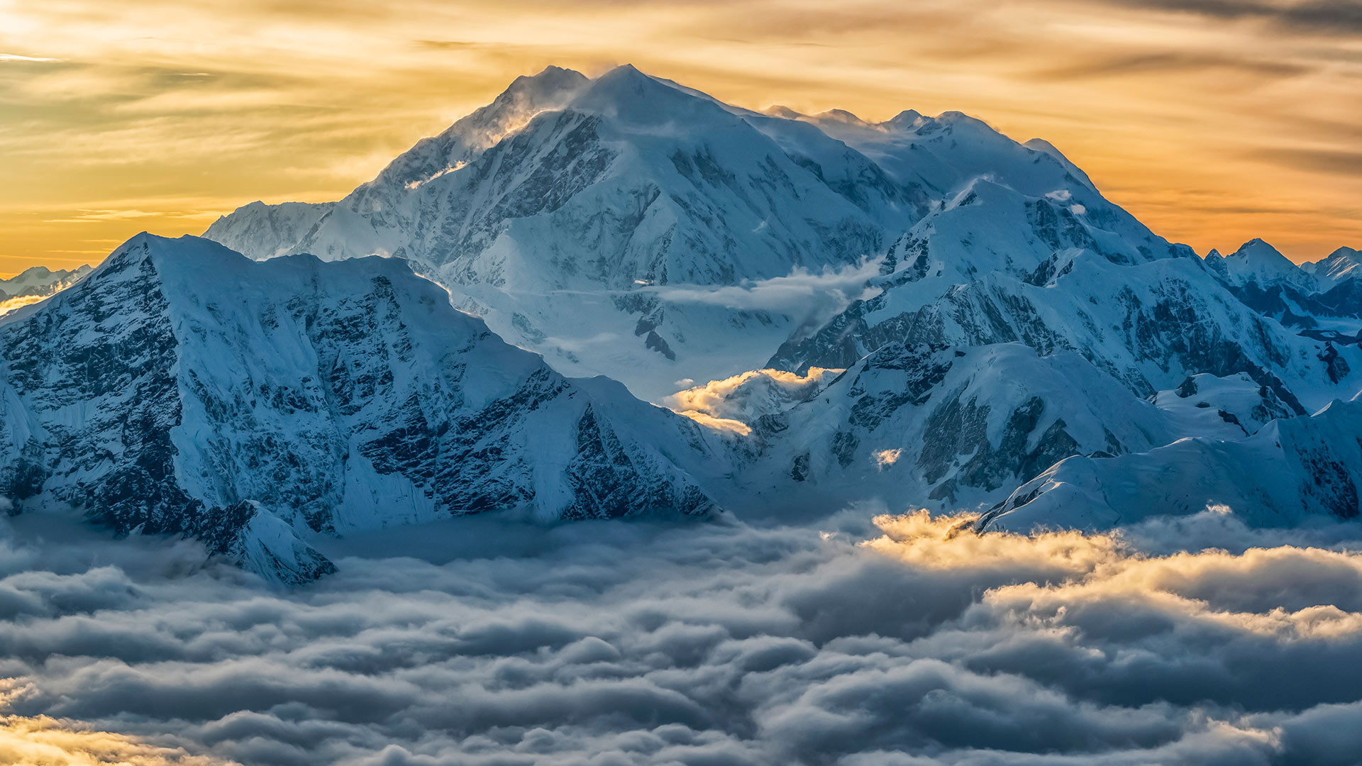
鸟瞰高耸入云的洛根山,加拿大克鲁瓦尼国家公园 Aerial image of Mount Logan rising above the clouds in Kluane National Park, Yukon, Canada (© plainpicture/Design Pics/Robert Postma)
鸟瞰高耸入云的洛根山,加拿大克鲁瓦尼国家公园 Aerial image of Mount Logan rising above the clouds in Kluane National Park, Yukon, Canada (© plainpicture/Design Pics/Robert Postma)
Walking in the clouds
Mount Logan is the highest mountain in Canada, and the second-highest peak in North America after Denali. The mountain was named after Sir William Edmond Logan, a Canadian geologist and founder of the Geological Survey of Canada (GSC). Logan is believed to have the largest base circumference of any non-volcanic mountain on Earth. Due to active tectonic uplifting, Mount Logan is still rising in height.
云中漫步
洛根山是加拿大的最高峰,也是北美仅次于德纳利的第二高峰。这座山是以加拿大地质学家、加拿大地质调查局(GSC)创始人威廉·埃德蒙德·洛根爵士的名字命名的。洛根被认为是地球上所有非火山山脉中基围最大的。由于活跃的构造抬升,洛根山仍在上升。
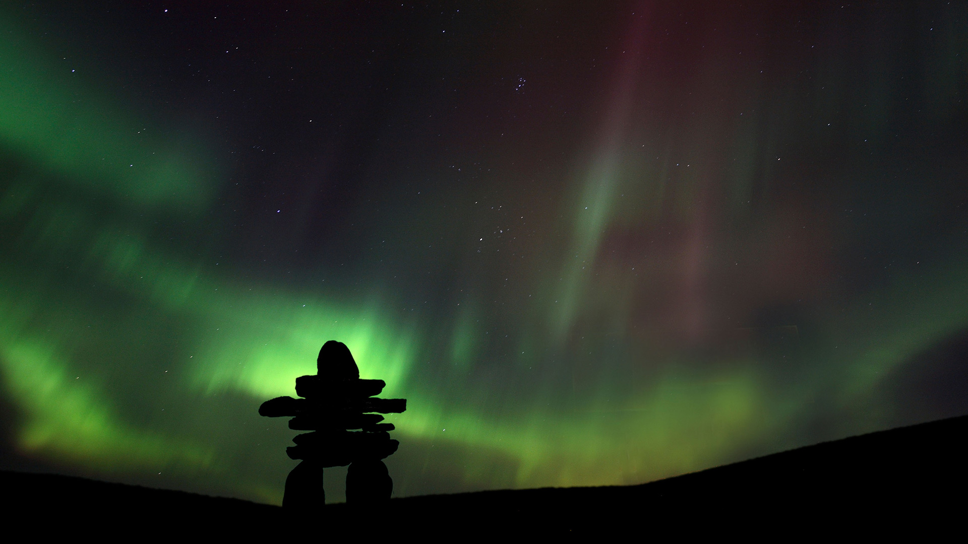
被北极光映衬出轮廓的因努伊特石堆,加拿大西北地区 Inukshuk silhouetted against the Northern Lights in Barren Lands, Northwest Territories, Canada (© Mark Duffy/Alamy)
被北极光映衬出轮廓的因努伊特石堆,加拿大西北地区 Inukshuk silhouetted against the Northern Lights in Barren Lands, Northwest Territories, Canada (© Mark Duffy/Alamy)
A symbol of culture and communication
In Arctic Canada, an inukshuk is a monument that is built and placed by the Inuit who were the first people to inhabit the region. It is used as an aid for navigation, hunting tasks and sits as a centre for communication as well. An Inukshuk is made of stacked stones and is an integral part of the Inuit culture. Every stone in the structure has a purpose. It could be a warning of danger, pointing to a fishing spot or even indicating where food is hidden. Since the Inukshuk serves as an important form of communication, destroying one is strictly prohibited in Inuit culture.
The human-like stone figure pictured here is commonly mistaken to be an inukshuk. The Inuit call it inunnquaq, which refers to ‘in the likeness of a human.’ This structure consists of a figure that resembles a human with arms, legs and a head. While it doesn’t necessarily serve the same purpose as the inukshuk, it stands as a popular cultural symbol that was also used as an emblem for the 2010 Winter Olympics in Vancouver.
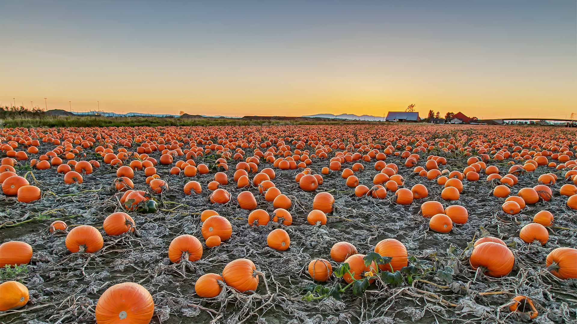
不列颠哥伦比亚省的一块南瓜田,加拿大 A pumpkin patch in British Columbia, Canada (© James Chen/Shutterstock)
不列颠哥伦比亚省的一块南瓜田,加拿大 A pumpkin patch in British Columbia, Canada (© James Chen/Shutterstock)
A most sincere pumpkin patch
Ah, the perennial pumpkin patch. You might think the round orange gourds in today's photo are vegetables, but botanists say pumpkins are actually the fruit of pumpkin vines. They're considered fruit because pumpkins contain seeds and grow from the same part of the plant that produces flowers. And now, as Halloween nears, pumpkins are ripe for picking and carving into spooky jack-o'-lanterns.
The jack-o'-lantern tradition dates to mid-1800s Ireland when people carved faces into potatoes or turnips to ward off evil spirits. Irish immigrants brought the tradition to North America, only to discover that native pumpkins were much easier to carve. Fast-speed ahead and we're just grateful that pumpkins are the seasonal 'fruit' of choice since turnips would make a questionable spiced-latte drink.
Bents的旧百货商店,加拿大萨斯喀彻温省 Old general store of Bents, Saskatchewan, Canada (© ImagineGolf/Getty Images)
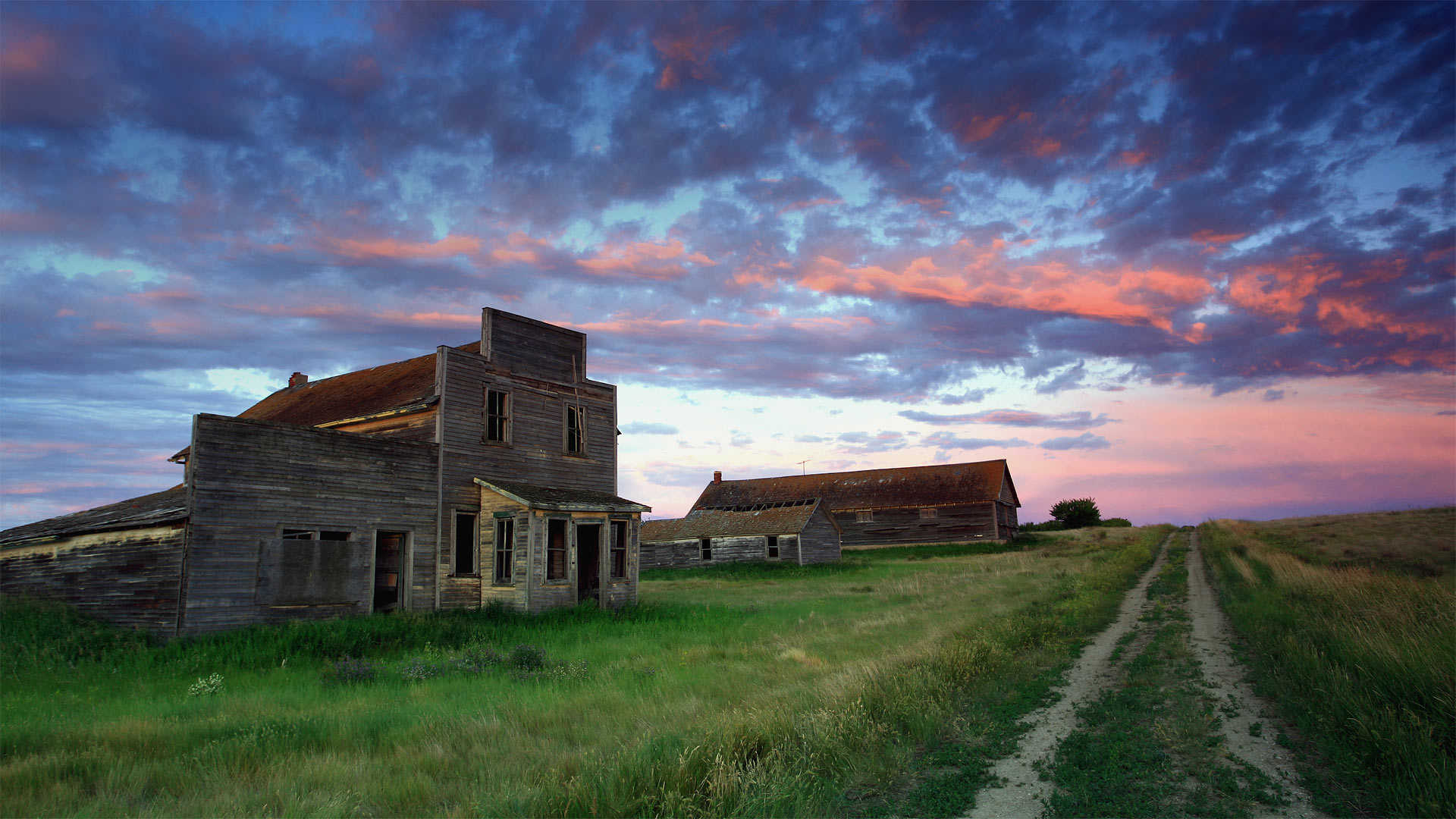
Bents的旧百货商店,加拿大萨斯喀彻温省 Old general store of Bents, Saskatchewan, Canada (© ImagineGolf/Getty Images)
Saskatchewan's spookier side
If you're greeted by a friendly face and a warm 'Welcome to Bents' as you stroll up to this old general store, you might be having a paranormal experience: It's been 50 years since a living soul dwelt in this Saskatchewan ghost town.
Built along one of the last spurs of track laid during central Canada's early-20th-century railroad boom, Bents didn't attract many residents before it quickly declined in the 1920s, when droughts stymied the region's wheat crop. By the '60s even the last hangers-on were gone, leaving only the shells of the store, grain elevator, and a few other assorted buildings. Plus of course any spirits who, nostalgic for the outpost's short-lived heyday, might still call it a favorite haunt.
温哥华东部的弗雷泽河和金耳朵山脉,加拿大不列颠哥伦比亚省 Fraser River east of Vancouver, British Columbia, Canada, with the Golden Ears mountains (© LeonU/Getty Images)
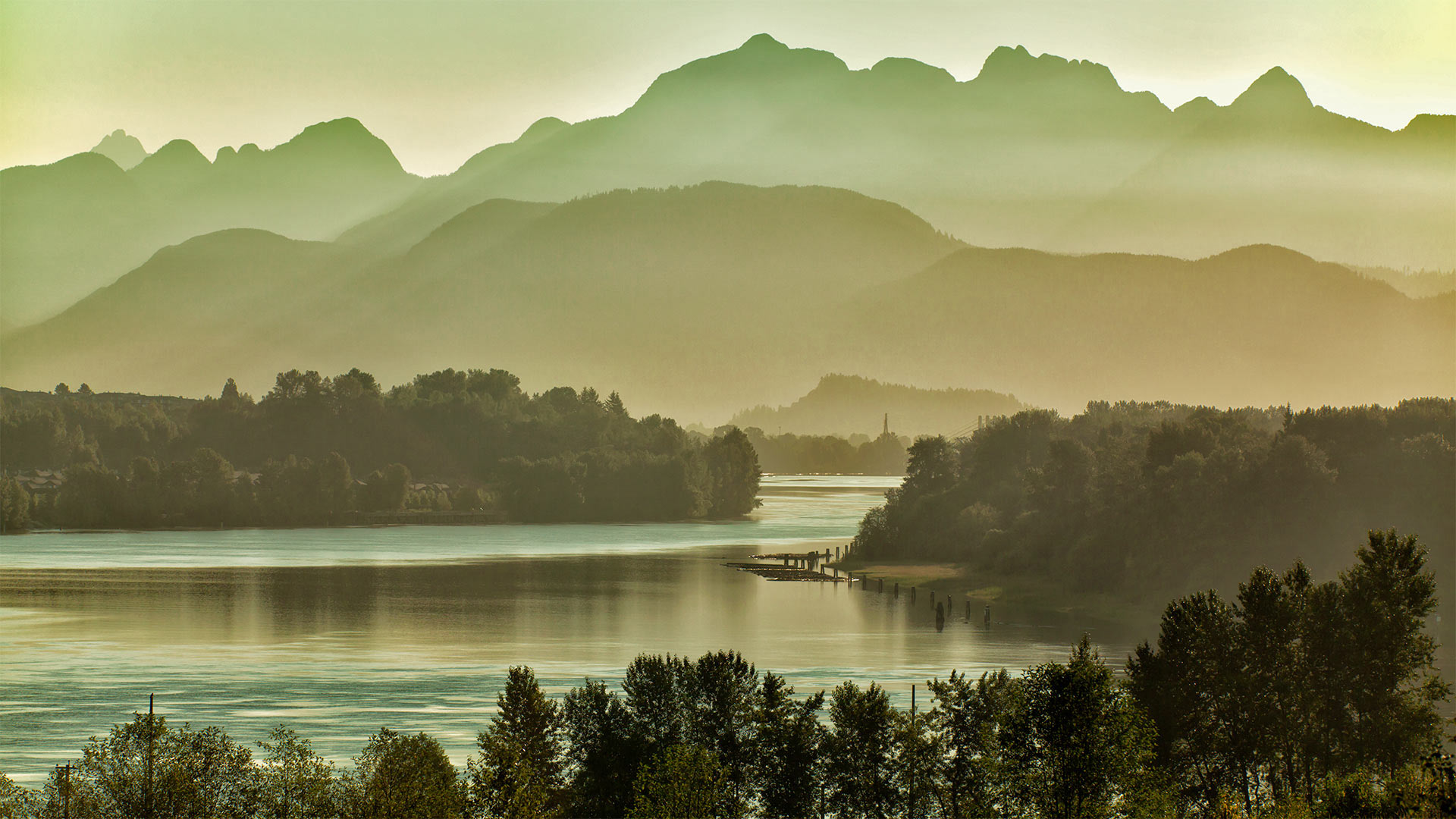
温哥华东部的弗雷泽河和金耳朵山脉,加拿大不列颠哥伦比亚省 Fraser River east of Vancouver, British Columbia, Canada, with the Golden Ears mountains (© LeonU/Getty Images)
Take me to the river
Today we're recognizing World Rivers Day—a conservation event that branched off in 2005 from its source, BC Rivers Day, founded near this British Columbia river's banks 40 years ago today. The Fraser River flows through a showcase of this Canadian province's diverse landscape: It originates in the Rocky Mountains, carves steep valleys through central BC, and irrigates rich farmlands outside Vancouver before spilling into the sea just south of the city. The river flows gently in this stretch, as seen from the span of the Port Mann Bridge east of Vancouver, with the Golden Ears mountains in the background. Thanks to preservation efforts, the Fraser's main stem remains completely undammed, with its drainage basin covering 25 percent of BC's land area.
A drainage basin is what we in the US usually call a watershed: Every river has tributaries, or other rivers and springs that flow into it and add to its volume. A river's watershed is the area covered by the main flow and all its tributaries put together. Watersheds may exist within other watersheds, such as when a tributary is longer than the river it feeds—a classic example is North America's longest river, the Missouri, whose vast watershed is a subdivision of the sea-bound yet shorter Mississippi's.
Delicate environments like rivers are interconnected, and actions have downstream effects—that's what World Rivers Day aims to highlight through hands-on cleanup opportunities and virtual events. Scroll down to search what's currently planned in your area.
奥卡诺根的斑点湖,加拿大不列颠哥伦比亚省 Spotted Lake in the Okanagan region of British Columbia, Canada (© Galyna Andrushko/Shutterstock)
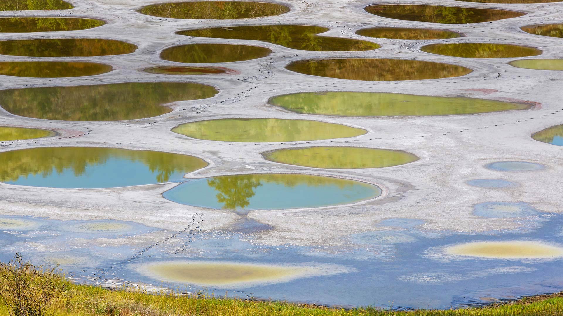
奥卡诺根的斑点湖,加拿大不列颠哥伦比亚省 Spotted Lake in the Okanagan region of British Columbia, Canada (© Galyna Andrushko/Shutterstock)
Spotted Lake emerges
This might look like the surface of some distant planet, but Spotted Lake is much closer to home. Just north of the US border in the Okanagan Valley of British Columbia, Canada, the lake's strange coloration is due to its high concentrations of mineral deposits. It's a protected cultural site of the Syilx/Okanagan Nation for its healing properties. Spotted Lake is an endorheic lake, which is a basin where water collects but has no river or sea to drain into. The water level rises with rainfall during autumn and winter and then as the days grow longer and hotter the water lowers as it evaporates. During the hot, dry summers in the Okanagan, Spotted Lake earns its name–large 'spots' in varying hues of blue, green, or yellow become more prominent as the water level drops. The area's closed to the public, but you can get a decent view from the highway. Binoculars recommended.
芬迪湾低潮时的洞穴及海岸地貌 ,加拿大新不伦瑞克 Caves and coastal features at low tide on the Bay of Fundy, near St. Martins, New Brunswick, Canada (© Jamie Roach/Shutterstock)
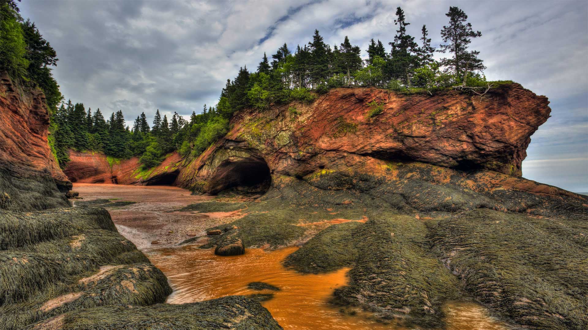
芬迪湾低潮时的洞穴及海岸地貌 ,加拿大新不伦瑞克 Caves and coastal features at low tide on the Bay of Fundy, near St. Martins, New Brunswick, Canada (© Jamie Roach/Shutterstock)
It's National Acadian Day
In honor of Canada's National Acadian Day, we're on the shores of New Brunswick as the ocean recedes to reveal the Bay of Fundy's massive intertidal zone. The tide is a big deal at the bay—more than five times bigger than in most places. Typical tides around the world have a range of 3 to 6 feet, but these waters drop as far as 50 feet from high to low tide.
National Acadian Day celebrates the legacy of the Acadians, Canada's first permanent French residents. The agrarian Acadians first settled what's now Nova Scotia in 1605 and spread to nearby areas, like this one, over that century, developing an identity distinct from the rest of New France. This unfortunately didn't shield them from Old World conflicts as France's longtime enemy, Britain, occupied and tried to conquer Acadia multiple times, finally succeeding in 1710. The British ultimately expelled the Acadians four decades later, a forced relocation to other British colonies where Acadians were often pressed into servitude—or to France, the mother country many Acadians never knew, and to which many wouldn't survive the voyage.
But that tragic chapter is far from the end of the Acadians' story. Some of them eventually returned to Acadia, and their culture still permeates Canada's Maritime provinces—as well as another unlikely locale. Thanks to France's friendly 18th-century relations with Spain, many exiled Acadians were able to settle the then-Spanish-controlled bayous of Louisiana—where 'Acadian' eventually morphed into 'Cajun.'
班夫国家公园中莫兰湖的延时视频,加拿大艾伯塔省 Time-lapse video of Moraine Lake in Banff National Park, Alberta, Canada (© Schroptschop/Getty Images)

班夫国家公园中莫兰湖的延时视频,加拿大艾伯塔省 Time-lapse video of Moraine Lake in Banff National Park, Alberta, Canada (© Schroptschop/Getty Images)
Canada's $20 view
For Canada Day, we're looking at Moraine Lake in Banff National Park. And if you're thinking that this amazing view is worth more than $20, you're right. But this priceless scene was once featured on Canada's $20 bill, hence the nickname. Canada Day, celebrated on July 1, commemorates the date in 1867 when Canada was recognized as a self-governing country under the British Empire It's not exactly Canadian Independence Day–it marks the passing of the Constitution Act of 1867, which was the first major step toward Canada's sovereignty.
Moraine Lake is just one of the many beautiful areas in Canada's oldest national park. Located in Alberta's Rocky Mountains, Banff covers more than 2,500 square miles–though we should say 6,641 square kilometres. After all, it's Canada Day.
火灾烧毁大部分森林后,野花遍地的凯尔特河野营地 Kettle River Recreation Area bursting with wildflowers after a fire destroyed much of the forest, British Columbia, Canada (© Debra Brash/plainpicture)
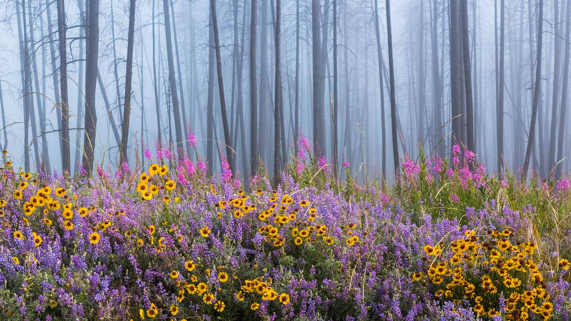
火灾烧毁大部分森林后,野花遍地的凯尔特河野营地 Kettle River Recreation Area bursting with wildflowers after a fire destroyed much of the forest, British Columbia, Canada (© Debra Brash/plainpicture)
Rising from the ashes
This dazzling display of colorful wildflowers is a result of a wildfire that raged through the forest here in British Columbia’s Kettle River Recreation Area. Wildfires in forests are natural and vital to the ecosystem. The heat from the burning tree dumps millions of seeds on the forest floor. Decaying flora turned into ash, releases nutrients in the soil which in turn invigorates the growth of new seedlings. The raging fire further contributes to an abundant new growth of plant matter by eliminating weeds and invasive insects. It also thus makes way for sunlight to immerse the forest floor enabling seeds to germinate and eventually bloom into a scene like our homepage today.