标签 亚利桑那 下的文章
下羚羊峡谷,亚利桑那州,美国 Lower Antelope Canyon near Page, Arizona (© AZCat/Getty Images)
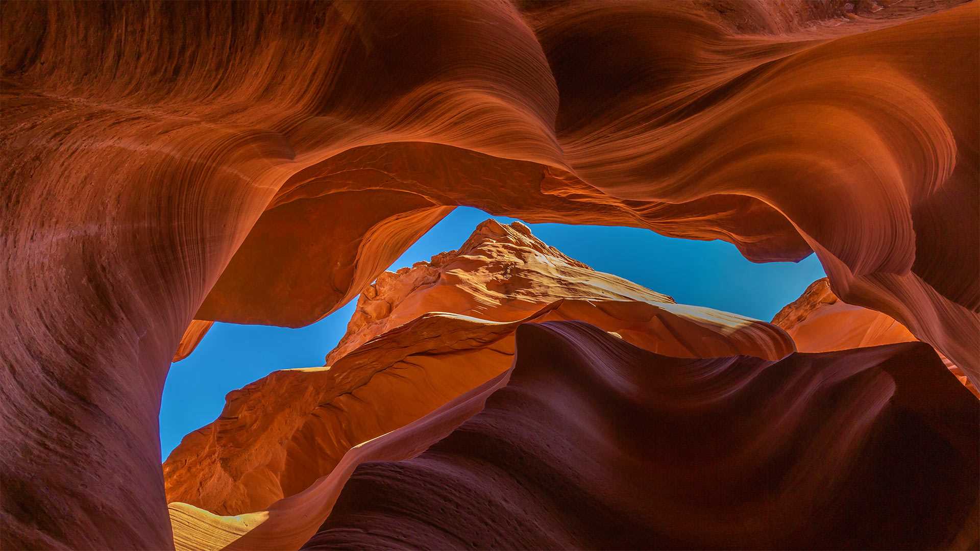
下羚羊峡谷,亚利桑那州,美国 Lower Antelope Canyon near Page, Arizona (© AZCat/Getty Images)
这些美丽的岩石波浪是什么? What are these beautiful sandy waves?
下羚羊峡谷,美国亚利桑那州
下羚羊峡谷是位于美国亚利桑纳州的一个美丽的自然景点。该峡谷也被原住民纳瓦霍人称为“螺旋石拱”。下羚羊峡谷不仅吸引了观景游客、徒步者,其鲜艳的色彩还吸引了许多摄影师。下羚羊峡谷呈“V”字形,这一独特的地貌是水流长年冲刷谷壁而形成的。羚羊峡谷的名字来源于纳瓦霍人的传说故事:过去,羚羊们会在冬天沿着峡谷漫步吃草。
Lower Antelope Canyon, Arizona
Lower Antelope Canyon is a beautiful natural tourist attraction located in Arizona. This canyon is also known as Hazdistazí (spiral rock arches) among the indigenous Navajo people. The canyon is not just a sight to behold and great for a hike, but with its beautiful hues is also a photographer's dream come true. The canyon is shaped like a 'V,' its unique geography created by water that rushed over its walls over many, many years. Antelope Canyon gets its name from Navajo stories regarding antelopes that grazed along the canyon in the wintertime.
大理石峡谷中横跨科罗拉多河的纳瓦霍桥,美国亚利桑那州北部 Marble Canyon bridges over the Colorado River at the Glen Canyon National Recreation Area in northern Arizona (© trekandshoot/Alamy)
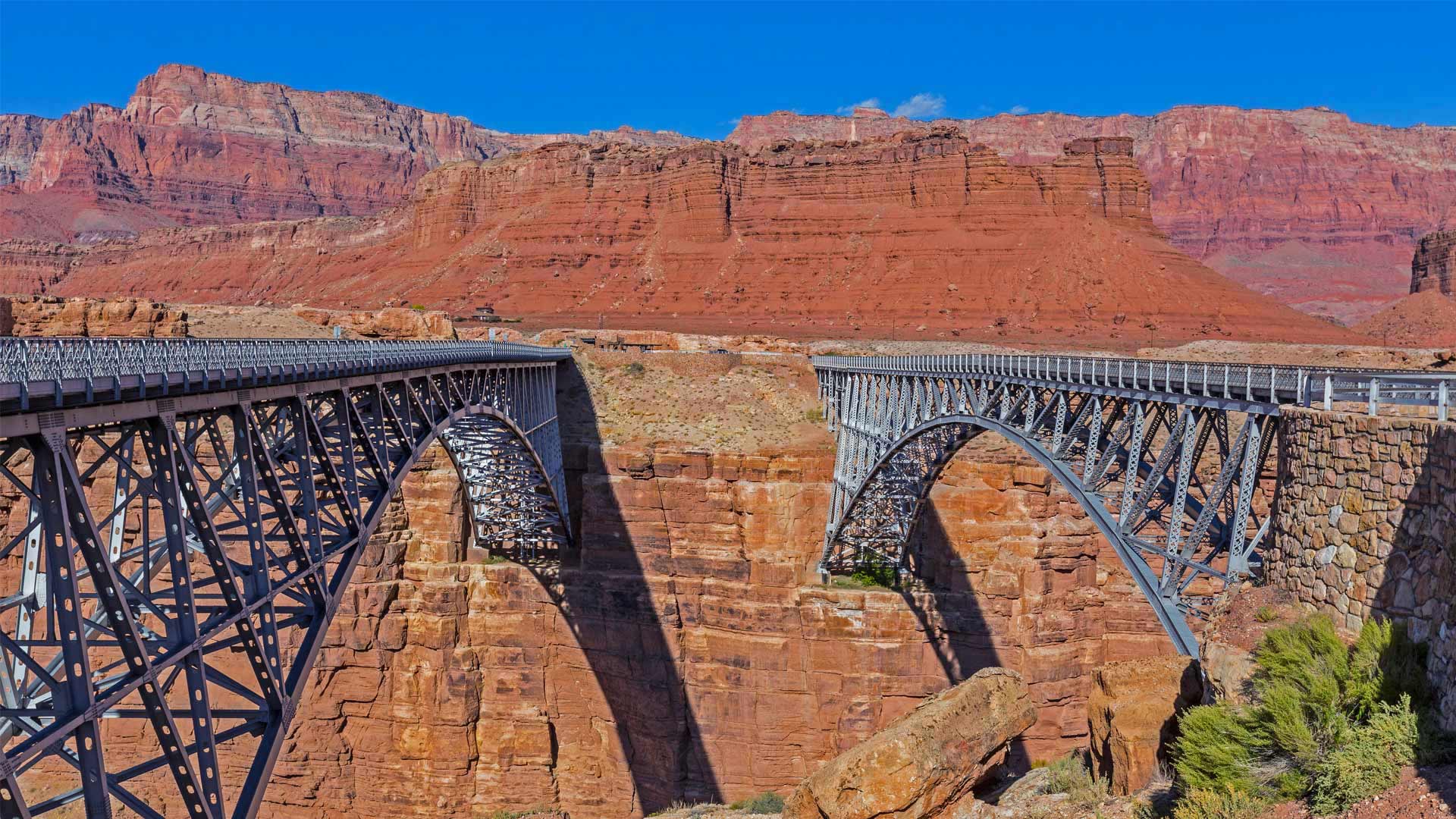
大理石峡谷中横跨科罗拉多河的纳瓦霍桥,美国亚利桑那州北部 Marble Canyon bridges over the Colorado River at the Glen Canyon National Recreation Area in northern Arizona (© trekandshoot/Alamy)
横跨峡谷裂缝的两座桥 Bridging the gap two ways
Happy birthday, bridges
Today we're taking a trip to a part of northern Arizona cut off from the rest of the state by the Colorado River and its deep canyons. No doubt you've heard of the Grand Canyon, but today is an important milestone to another canyon about 70 miles away. On this date in 1995, the twin Marble Canyon bridges, better known collectively as Navajo Bridge, were officially dedicated as the second bridge was installed.
The first, in place since 1929 when it was hailed as a 'modern marvel' and 'the biggest news in Southwest history,' had long been key to travel across the 834-foot gap of Marble Canyon. But as time passed, the area saw heavier vehicles and more traffic. After much debate about the impact on Native land and endangered plants, and the likelihood of debris falling into the river below, plans were developed for the $14.7 million, nearly identical second bridge. Now, Marble Canyon has two bridges, each about 470 feet over the Colorado River. The original serves as a path for humans and horses while the new bridge carries vehicles. Both bridges hold the title of ninth-highest in the United States (though the newer one is about three feet higher).
生日快乐,桥
今天,我们将前往亚利桑那州北部的一个地区,那里被科罗拉多河及其深峡谷与该州的其他地区隔绝。毫无疑问,你听说过大峡谷,但今天是70英里外另一个峡谷的重要里程碑。1995年的这一天,两座大理石峡谷大桥(合称纳瓦霍桥)正式投入使用,第二座大桥也安装完毕。
自1929年被誉为“现代奇迹”和“西南历史上最大的新闻”以来,第一条铁路一直是穿越834英尺高的大理石峡谷的关键。但随着时间的推移,该地区的车辆越来越重,交通也越来越多。在对当地土地和濒危植物的影响以及碎片落入河流的可能性进行了大量辩论后,为价值1470万美元、几乎相同的第二座桥梁制定了计划。现在,大理石峡谷有两座桥,每座桥跨越科罗拉多河约470英尺。最初的桥梁是人和马的通道,而新的桥梁则承载车辆。这两座桥都是美国第九高的桥梁(尽管较新的桥高约三英尺)。
北狼丘里的"波浪谷",美国亚利桑那州 'The Wave' sandstone formation in Coyote Buttes North, Paria Canyon-Vermilion Cliffs National Monument, Arizona (© Dennis Frates/Alamy)
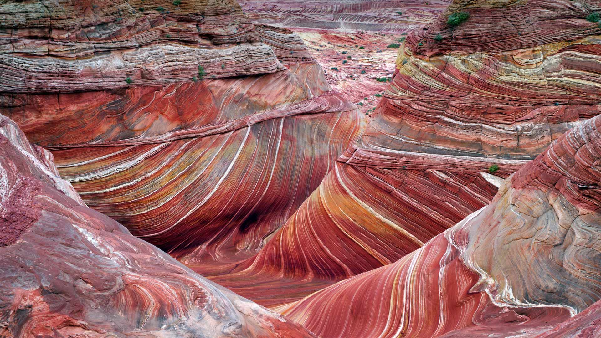
北狼丘里的"波浪谷",美国亚利桑那州 'The Wave' sandstone formation in Coyote Buttes North, Paria Canyon-Vermilion Cliffs National Monument, Arizona (© Dennis Frates/Alamy)
乘风破浪 Ride the wave
The Wave at Coyote Buttes
By showing you this coveted sight, we're saving you a bit of an ordeal. For a close-up view like this of 'The Wave,' a whorled sandstone formation in the northern Arizona wilderness, you'd have to navigate a rugged and mostly trail-free hiking route in typically scorching temperatures. You'd also need to have a permit in your pocket. To protect the landscape, only a small number are available, offered through a daily lottery. But maybe for you the journey is at least as important as the destination? If so, this is just one hike of many in the expansive Paria Canyon-Vermilion Cliffs National Monument, which protects more than 100,000 acres of Arizona and Utah canyonland.
郊狼丘上的波浪
通过向你们展示这一令人垂涎的景象,我们为你们省去了一点磨难。要想近距离拍摄“The Wave”,这是亚利桑那州北部荒野中的一个螺纹砂岩地层,你必须在典型的酷热天气下,沿着崎岖不平、几乎没有足迹的徒步路线行走。你还需要口袋里有许可证。为了保护景观,只有少数人可以通过每日彩票获得。但也许对你来说,旅程至少和目的地一样重要?如果是这样的话,这只是帕里亚峡谷朱红色悬崖国家纪念碑中众多徒步旅行中的一次,该纪念碑保护着亚利桑那州和犹他州超过10万英亩的峡谷地。
科罗拉多河上的马蹄湾,美国亚利桑那州 Horseshoe Bend, Arizona (© Michael Dunn/Getty Images)
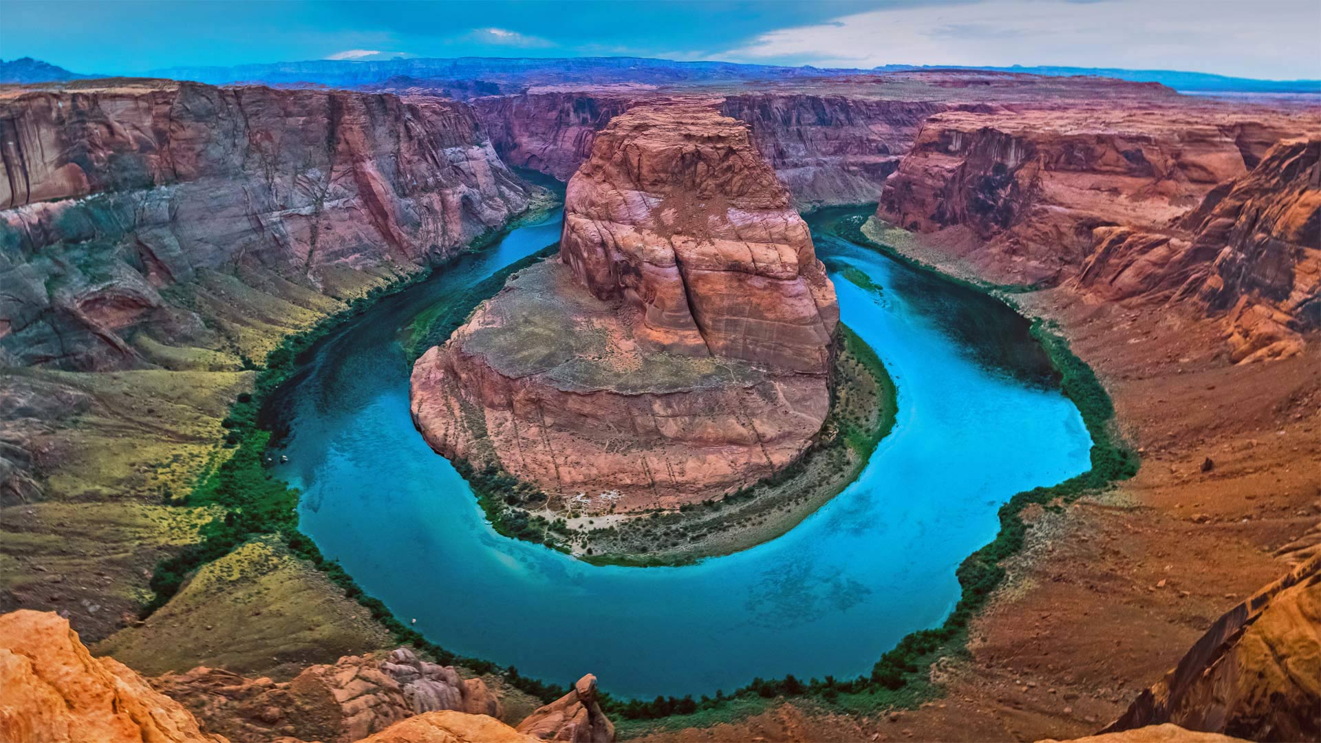
科罗拉多河上的马蹄湾,美国亚利桑那州 Horseshoe Bend, Arizona (© Michael Dunn/Getty Images)
打卡马蹄湾会带来好运吗? Does this horseshoe bring good luck?
Horseshoe Bend, Arizona
Grab your boots and gear, today we're heading to Arizona to hike out to Horseshoe Bend. Known as the 'east rim of the Grand Canyon,' it's actually about 140 miles from the other rims and is really more a part of nearby Glen Canyon. Scientifically, the beautiful view exists thanks to something called an 'entrenched meander.' Around six million years ago, the area was closer to sea level. The Colorado River, following the path of least resistance, meandered and became trapped when the Colorado Plateau uplifted around five million years ago. Over time, the river water cut through exposed sandstone, forming the thousand-foot-deep, 270-degree horseshoe-shaped bend.
Horseshoe Bend used to be a locally loved gem until social media came around to spread photos like this one. Now, nearly two million tourists a year hike to this national splendor. It's believed that, eventually, the Colorado River will cut through the neck of the bend. So, if you want your selfie with the horseshoe, you only have another million years, give or take.
亚利桑那州马蹄湾
带上你们的靴子和装备,今天我们要去亚利桑那州徒步去马蹄弯。它被称为“大峡谷的东边缘”,实际上距离其他边缘约140英里,实际上更像是附近格伦峡谷的一部分。从科学角度讲,这美丽的景色之所以存在,是因为有一种叫做“根深蒂固的曲流”的东西大约600万年前,该地区接近海平面。科罗拉多河沿着阻力最小的路径蜿蜒而行,在大约500万年前科罗拉多高原抬升时陷入困境。随着时间的推移,河水穿过裸露的砂岩,形成了千英尺深、270度马蹄形的弯曲。
马蹄弯曾经是当地人喜爱的珍宝,直到社交媒体开始传播像这样的照片。现在,每年有近200万游客徒步前往这个国家的辉煌。据信,科罗拉多河最终将穿过弯道的颈部。所以,如果你想在马蹄铁上自拍,你只能再活一百万年,不管付出与否。
雷暴下的大峡谷国家公园,亚利桑那州 Grand Canyon National Park during a thunderstorm, Arizona (© spkeelin/Getty Images)
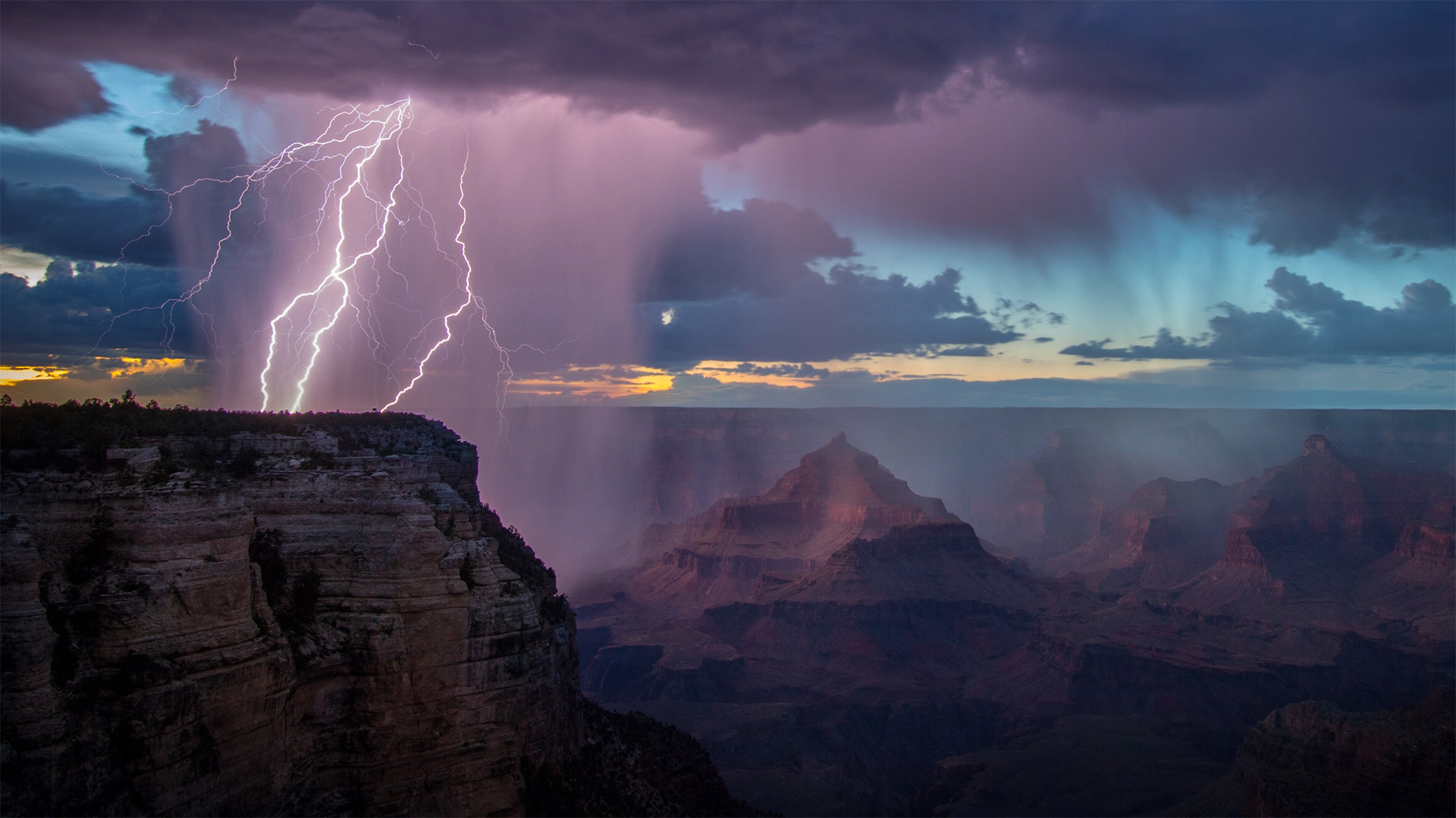
雷暴下的大峡谷国家公园,亚利桑那州 Grand Canyon National Park during a thunderstorm, Arizona (© spkeelin/Getty Images)
天气预报的重要性 The importance of weather prediction
World Meteorological Day
Did you check the weather forecast today? Does it look like rain? Will it turn colder? What's the outlook for the weekend? These may be some of the most frequently asked questions anywhere. Given our reliance on weather prediction, let's tip the rain hat to the world's weather experts on World Meteorological Day, celebrated each March 23 by the United Nation's World Meteorological Organization (WMO).
The 2022 theme for World Meteorological Day is 'Early Warning and Early Action. Hydrometeorological and Climate Information for Disaster Risk Reduction.' That's a mouthful, but it essentially boils down to the importance of predicting high-precipitation weather events and mitigating or preventing the damage caused by them.
Worldwide, floods cause more than $40 billion in damage each year. They're the most common type of natural disaster. In the United States flash floods claim more lives than tornadoes, hurricanes, or lightning. But with accurate predictions and appropriate warning systems, people living in an area likely to flood can know the severity of upcoming threats and plan accordingly. Thanks to the study of hydrometeorology, forecasts can predict the impact days and even weeks in advance. Long-term projections can even give an idea of what's coming several months from now. And we thought that weather app was just to tell us whether or not we'll need an umbrella.
世界气象日
你看过今天的天气预报了吗?看起来要下雨吗?天气会变冷吗?周末的前景如何?这些可能是任何地方最常被问到的问题之一。鉴于我们对天气预报的依赖,让我们在每年3月23日由联合国世界气象组织(WMO)庆祝的世界气象日向世界气象专家致敬。
2022年世界气象日的主题是“预警和早期行动”。减少灾害风险的水文气象和气候信息。”这是一口空话,但本质上可以归结为预测高降水天气事件以及减轻或防止它们造成的损害的重要性。
在世界范围内,洪水每年造成超过400亿美元的损失。它们是最常见的自然灾害类型。在美国,山洪暴发夺走的生命比龙卷风、飓风或闪电还多。但是,有了准确的预测和适当的预警系统,生活在可能发生洪水的地区的人们可以知道即将到来的威胁的严重性,并据此制定计划。由于对水文气象学的研究,预报可以提前几天甚至几周预测影响。长期预测甚至可以给出几个月后的情况。我们以为天气应用程序只是告诉我们是否需要雨伞。
有着丰富石化木材的石化林国家公园,美国亚利桑那州 Petrified Forest National Park, Arizona (© Ian Shive/Tandem Stills + Motion)
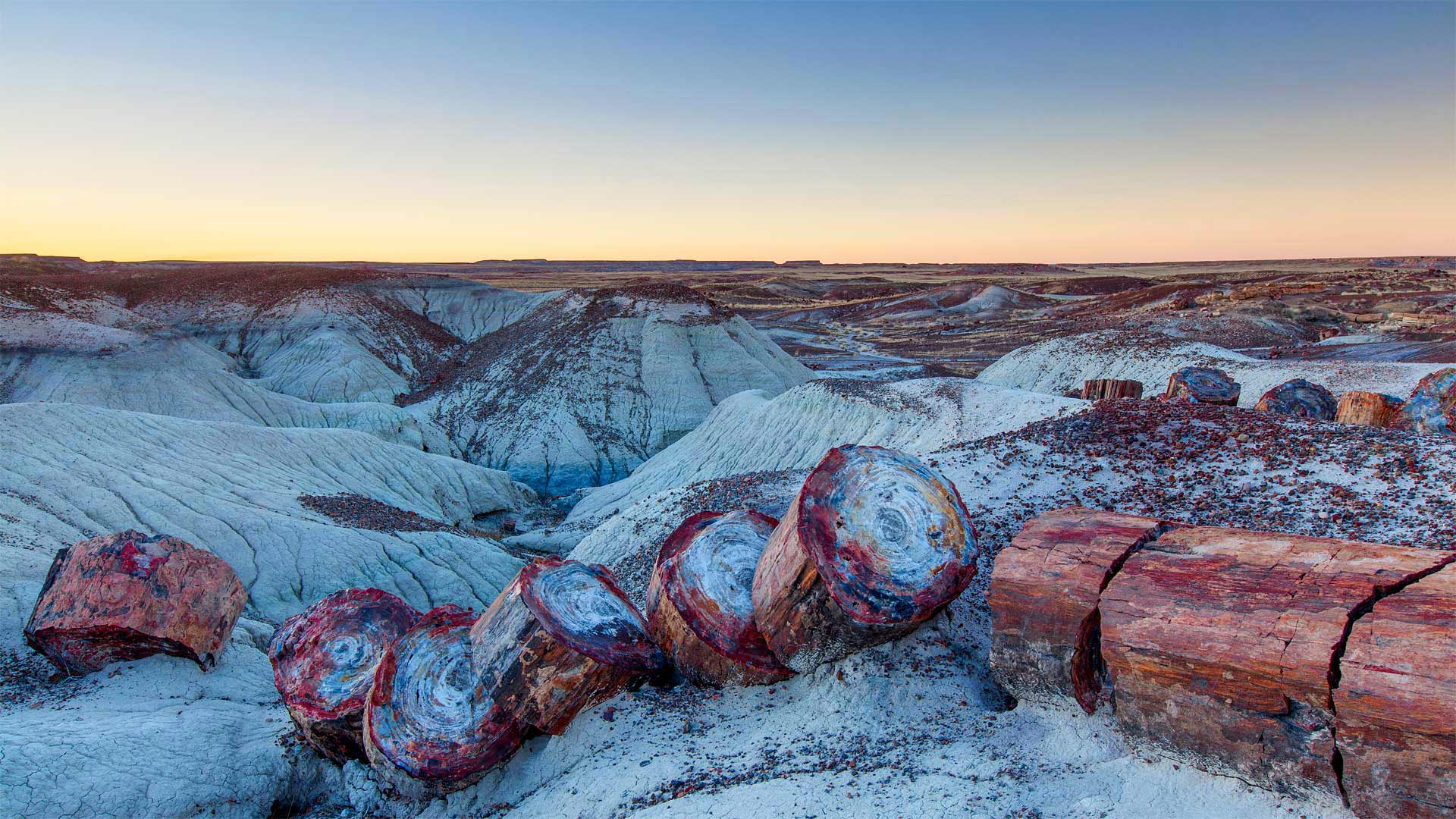
有着丰富石化木材的石化林国家公园,美国亚利桑那州 Petrified Forest National Park, Arizona (© Ian Shive/Tandem Stills + Motion)
Petrified Forest National Park
The burliest lumberjack with the best-oiled chainsaw couldn't slice the massive 'timbers' found in Petrified Forest National Park. So why are these giant stone logs segmented in such symmetrical stumps?
Each of these smooth splits occurred in an instant as the brittle quartz cracked under geologic pressure. But each of those instants was eons in the making. First, 225 million years ago, the trees were buried by torrents of river silt. Then mineral deposits slowly seeped into the trees and replaced the decaying wood. Much later, around 60 million years ago, the entire Colorado Plateau began shifting, generating crushing forces that finally divided the petrified logs.
The fossilized trees, surrounding land, and the many plants and animals that live here have enjoyed protection since December 8, 1906, when President Theodore Roosevelt created Petrified Forest National Monument. It was designated as a national park in 1962, lending still greater protection.
石化森林国家公园
最结实的伐木工人和最好的油锯无法切割石化森林国家公园中发现的巨大“木材”。那么,为什么这些巨石原木被分割成如此对称的树桩呢?
当脆性石英在地质压力下破裂时,每一个光滑的裂缝都会在瞬间发生。但是,每一个瞬间都在酝酿中。首先,2.25亿年前,这些树木被河流淤泥的洪流所掩埋。然后,矿物质慢慢渗入树木,取代了腐烂的木材。很久以后,大约6000万年前,整个科罗拉多高原开始移动,产生了最终分裂石化原木的压碎力。
自1906年12月8日西奥多·罗斯福总统创建石化森林国家纪念碑以来,这里的树木化石、周围的土地和许多动植物一直受到保护。1962年,它被指定为国家公园,提供了更大的保护。
美国大峡谷北缘的天使之窗,亚利桑那州 Peekaboo view of Angels Window on the North Rim of the Grand Canyon, Arizona (© Tim Fitzharris/Minden Pictures)
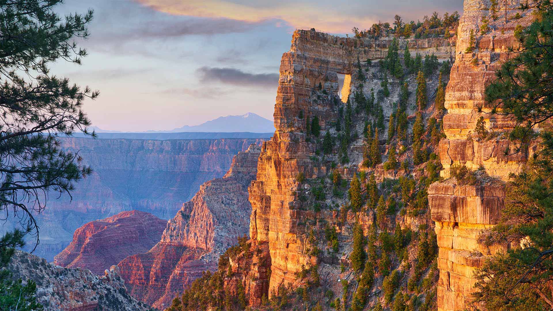
美国大峡谷北缘的天使之窗,亚利桑那州 Peekaboo view of Angels Window on the North Rim of the Grand Canyon, Arizona (© Tim Fitzharris/Minden Pictures)
Happy anniversary to the National Park Service!
On the National Park Service's Founders Day, we're here on the North Rim of Grand Canyon National Park in Arizona peering out at the stunning vista. Can you see the rectangular hole in the canyon wall near the top of the image? That's Angels Window. Brave hikers can make their way up to the trail above it, but the window itself is best viewed from various points along the North Rim. Far down below is the Colorado River. Beginning about 6 million years ago, it gradually carved downward through countless layers of sedimentary, igneous, and metamorphic rock. The Colorado and its tributary streams continue to deepen and widen the Grand Canyon even today.
The first national park, not only in the US, but also in the world, was Yellowstone, which was designated as a park in 1872. It was followed by Sequoia, Yosemite, and Mt. Rainier. While the Grand Canyon seems like an obvious choice for a national park, land and mining moguls kept it from becoming protected as a park for years. It finally became a national park in 1919, three years after the National Park Service was created on August 25, 1916. Each year on August 25, Founders Day is celebrated in all the national parks, where entrance fees are waived in honor of the occasion.
祝国家公园管理局周年快乐!
在国家公园管理局的创始人日,我们来到亚利桑那州大峡谷国家公园的北缘,眺望着令人惊叹的美景。你能看到图片顶部附近峡谷壁上的矩形洞吗?那是天使的窗户。勇敢的徒步旅行者可以爬上它上面的小径,但是从北边的各个点上看窗户本身是最好的。下面远处是科罗拉多河。从大约600万年前开始,它逐渐向下切割无数层沉积岩、火成岩和变质岩。即使在今天,科罗拉多河及其支流仍在继续加深和加宽大峡谷。
不仅在美国,而且在世界上,第一个国家公园是黄石公园,它于1872年被指定为公园。随后是红杉、约塞米蒂和雷尼尔山。虽然大峡谷似乎是国家公园的一个明显选择,但土地和矿业巨头多年来一直没有将其作为公园加以保护。1919年,在1916年8月25日国家公园管理局成立三年后,它最终成为了国家公园。每年8月25日,所有国家公园都庆祝创始人日,为纪念这一天免收入场费。
波浪谷中的砂岩层和积水,亚利桑那州朱红悬崖国家纪念碑 Sandstone formation and pools of water in 'The Wave,' Paria Canyon-Vermilion Cliffs National Monument, Arizona (© Dennis Frates/Alamy)
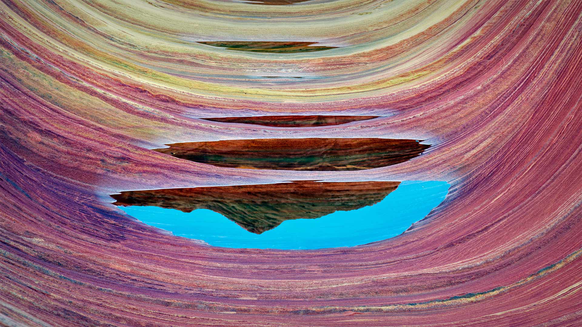
波浪谷中的砂岩层和积水,亚利桑那州朱红悬崖国家纪念碑 Sandstone formation and pools of water in 'The Wave,' Paria Canyon-Vermilion Cliffs National Monument, Arizona (© Dennis Frates/Alamy)
A sea of swirling stone
By showing you this coveted sight, we're saving you a bit of an ordeal. For close-up view like this of 'The Wave,' a whorled sandstone formation in the northern Arizona wilderness, you'd have to navigate a rugged and mostly trail-free route with a permit in your pocket (only a small number are available, offered via a daily lottery). But that's just one day hike of many in the expansive Vermilion Cliffs National Monument, which encompasses almost 300,000 acres of Arizona and Utah canyonland.
漩涡石海
通过向你展示这令人垂涎的景象,我们给你省了一点痛苦。像这样近距离观看“海浪”是亚利桑那州北部荒野的一个螺纹砂岩地层,你必须在口袋里带着许可证(只有很少的一部分是可用的,通过每天的抽奖提供)在崎岖不平且几乎没有踪迹的路线上航行。但这仅仅是许多人在广阔的朱红悬崖国家纪念碑上一天的徒步旅行,这座纪念碑覆盖了亚利桑那州和犹他州近30万英亩的峡谷。
图森北部托托利塔山麓上空的雷暴,亚利桑那州索诺拉沙漠 Lightning storm in the Tortolita Mountain foothills, north of Tucson, Arizona, in the Sonoran Desert (© Jack Dykinga/Minden Pictures)
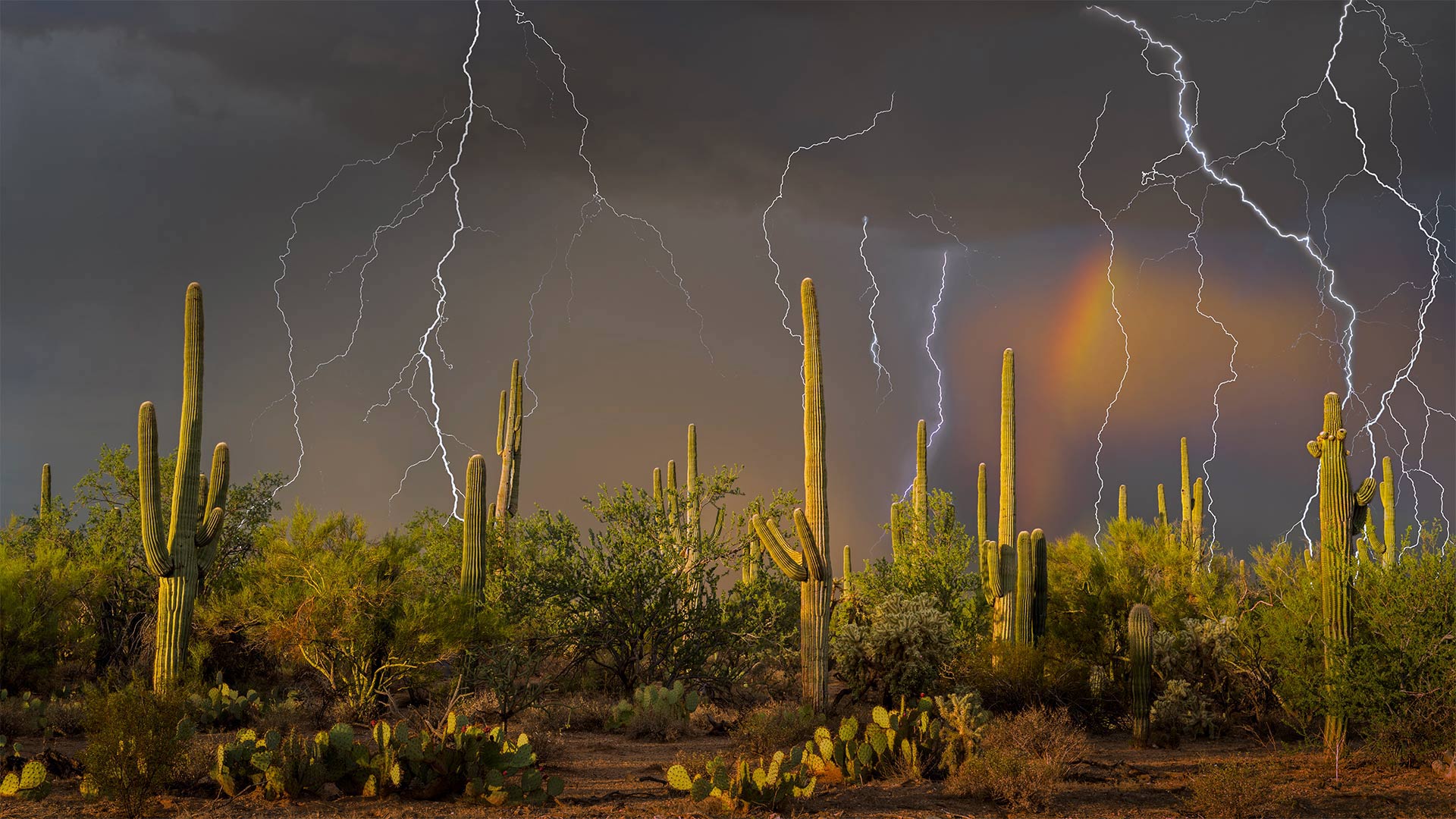
图森北部托托利塔山麓上空的雷暴,亚利桑那州索诺拉沙漠 Lightning storm in the Tortolita Mountain foothills, north of Tucson, Arizona, in the Sonoran Desert (© Jack Dykinga/Minden Pictures)
The monsoon arrives in the desert
Lightning strikes are common during the summer monsoon of the American Southwest. In Arizona and New Mexico, powerful thunderstorms roll in most every afternoon from early July until mid-September. Here, in the Sonoran Desert north of Tucson, Arizona, the severe weather over the saguaro cactus makes for a dramatic scene.
The monsoon–which refers to the entire season and not just a single storm—is caused by intense daytime heat, which drives shifts in wind patterns that bring moist air to the generally arid Southwest. Mornings typically begin fair, but as temperatures rise throughout the day, precipitation gathers into clouds that finally burst in periods of heavy rain during the late afternoon and evening. The monsoon storms also bring huge dust storms called 'haboobs,' borrowing the name from similar storms in Sudan.
In Arizona, the monsoon can account for nearly half the state's annual rainfall, which averages little more than 7 inches. Water is precious in the desert, and the region relies on this weather pattern to fill reservoirs and maintain the fragile ecosystem. While dry lightning early in the season can spark wildfires, as the monsoon rain starts to fall, it helps reduce local fire danger.
大峡谷哈瓦苏溪上的海狸瀑布,亚利桑那州 Beaver Falls on Havasu Creek in the Grand Canyon, Arizona (© Edwin Verin/Alamy)
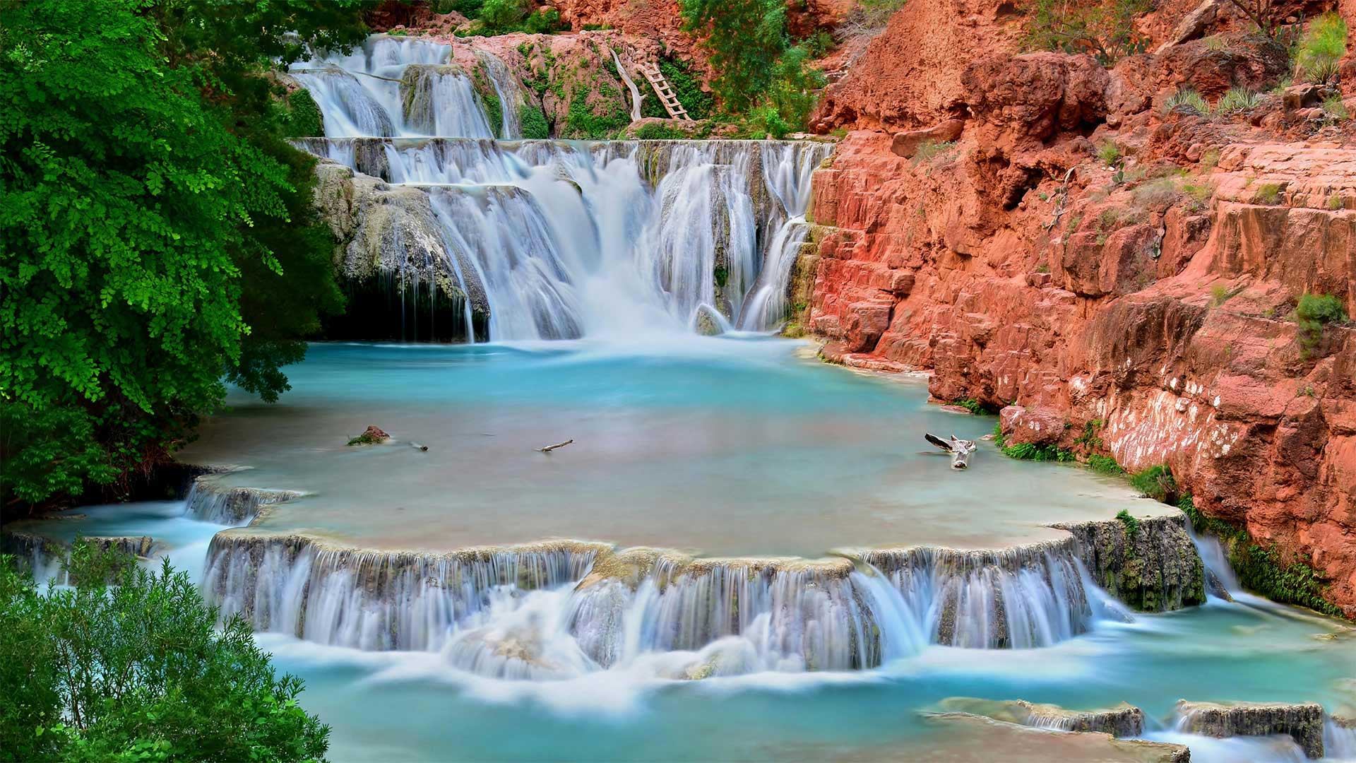
大峡谷哈瓦苏溪上的海狸瀑布,亚利桑那州 Beaver Falls on Havasu Creek in the Grand Canyon, Arizona (© Edwin Verin/Alamy)
Don't go chasing waterfalls
The stunning limestone travertine steps of Beaver Falls are the last in a series of five waterfalls along Havasu Creek, near the bottom of the Grand Canyon. The water gets its turquoise color from calcium carbonate, which reflects the beautiful hue and creates an ever-changing tableau; the minerals are deposited, moved, and redeposited to create new formations.
Getting to Beaver Falls is only for the adventurous—and lucky. First, you need a permit for Havasupai campground, which typically sell out in a day. From there, it's a 4-mile strenuous hike on rugged terrain with frequent water crossings, narrow ledges, and chains and ladders to assist when the trail gets especially precarious.
Your persistence is rewarded with pools for swimming, a natural waterslide, and stunning red rock canyon views. It's no wonder this region is sacred to the Havasupai, whose name means 'people of the blue-green water.'