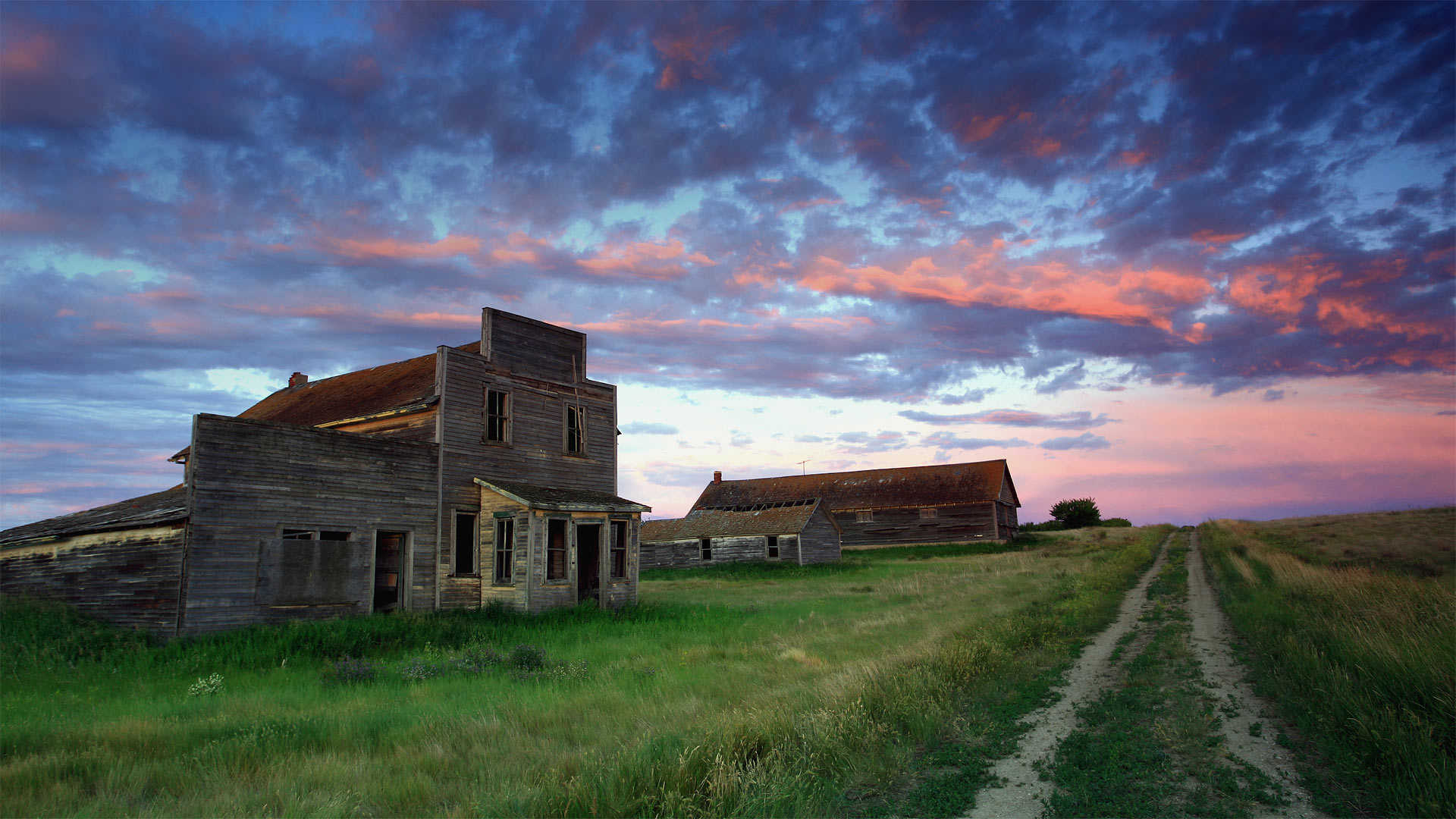
Bents的旧百货商店,加拿大萨斯喀彻温省 Old general store of Bents, Saskatchewan, Canada (© ImagineGolf/Getty Images)
Bents的旧百货商店,加拿大萨斯喀彻温省 Old general store of Bents, Saskatchewan, Canada (© ImagineGolf/Getty Images)
Saskatchewan's spookier side
If you're greeted by a friendly face and a warm 'Welcome to Bents' as you stroll up to this old general store, you might be having a paranormal experience: It's been 50 years since a living soul dwelt in this Saskatchewan ghost town.
Built along one of the last spurs of track laid during central Canada's early-20th-century railroad boom, Bents didn't attract many residents before it quickly declined in the 1920s, when droughts stymied the region's wheat crop. By the '60s even the last hangers-on were gone, leaving only the shells of the store, grain elevator, and a few other assorted buildings. Plus of course any spirits who, nostalgic for the outpost's short-lived heyday, might still call it a favorite haunt.
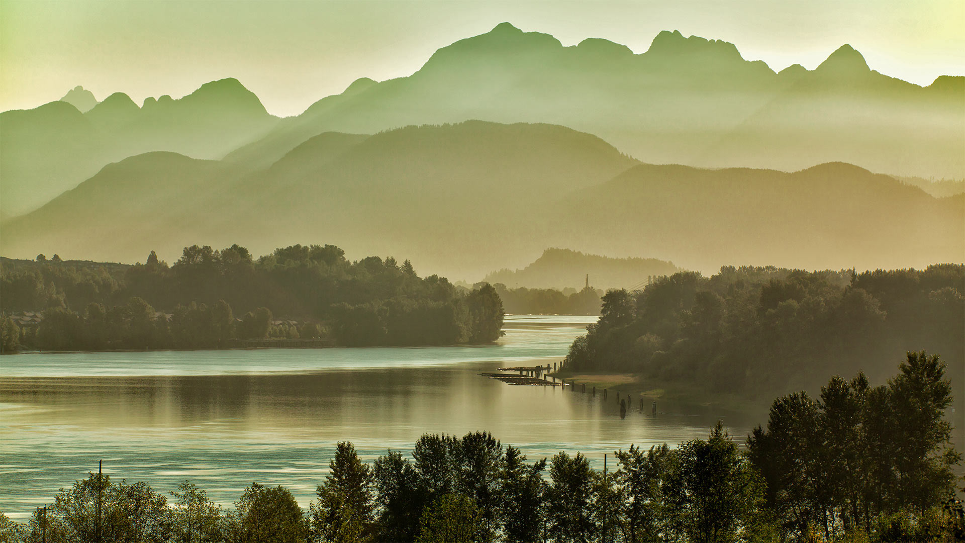
温哥华东部的弗雷泽河和金耳朵山脉,加拿大不列颠哥伦比亚省 Fraser River east of Vancouver, British Columbia, Canada, with the Golden Ears mountains (© LeonU/Getty Images)
温哥华东部的弗雷泽河和金耳朵山脉,加拿大不列颠哥伦比亚省 Fraser River east of Vancouver, British Columbia, Canada, with the Golden Ears mountains (© LeonU/Getty Images)
Take me to the river
Today we're recognizing World Rivers Day—a conservation event that branched off in 2005 from its source, BC Rivers Day, founded near this British Columbia river's banks 40 years ago today. The Fraser River flows through a showcase of this Canadian province's diverse landscape: It originates in the Rocky Mountains, carves steep valleys through central BC, and irrigates rich farmlands outside Vancouver before spilling into the sea just south of the city. The river flows gently in this stretch, as seen from the span of the Port Mann Bridge east of Vancouver, with the Golden Ears mountains in the background. Thanks to preservation efforts, the Fraser's main stem remains completely undammed, with its drainage basin covering 25 percent of BC's land area.
A drainage basin is what we in the US usually call a watershed: Every river has tributaries, or other rivers and springs that flow into it and add to its volume. A river's watershed is the area covered by the main flow and all its tributaries put together. Watersheds may exist within other watersheds, such as when a tributary is longer than the river it feeds—a classic example is North America's longest river, the Missouri, whose vast watershed is a subdivision of the sea-bound yet shorter Mississippi's.
Delicate environments like rivers are interconnected, and actions have downstream effects—that's what World Rivers Day aims to highlight through hands-on cleanup opportunities and virtual events. Scroll down to search what's currently planned in your area.
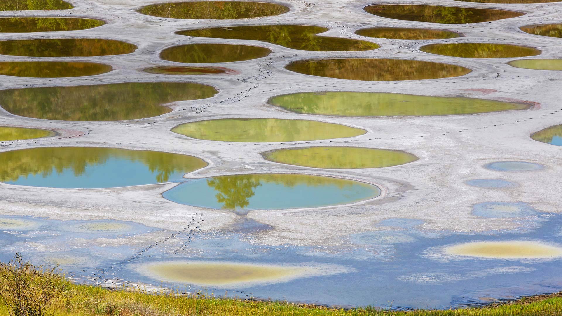
奥卡诺根的斑点湖,加拿大不列颠哥伦比亚省 Spotted Lake in the Okanagan region of British Columbia, Canada (© Galyna Andrushko/Shutterstock)
奥卡诺根的斑点湖,加拿大不列颠哥伦比亚省 Spotted Lake in the Okanagan region of British Columbia, Canada (© Galyna Andrushko/Shutterstock)
Spotted Lake emerges
This might look like the surface of some distant planet, but Spotted Lake is much closer to home. Just north of the US border in the Okanagan Valley of British Columbia, Canada, the lake's strange coloration is due to its high concentrations of mineral deposits. It's a protected cultural site of the Syilx/Okanagan Nation for its healing properties. Spotted Lake is an endorheic lake, which is a basin where water collects but has no river or sea to drain into. The water level rises with rainfall during autumn and winter and then as the days grow longer and hotter the water lowers as it evaporates. During the hot, dry summers in the Okanagan, Spotted Lake earns its name–large 'spots' in varying hues of blue, green, or yellow become more prominent as the water level drops. The area's closed to the public, but you can get a decent view from the highway. Binoculars recommended.
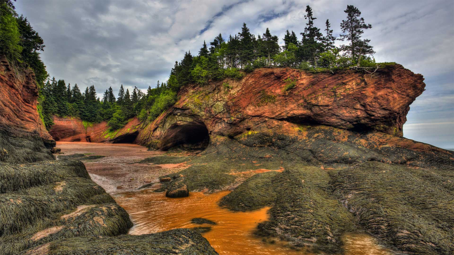
芬迪湾低潮时的洞穴及海岸地貌 ,加拿大新不伦瑞克 Caves and coastal features at low tide on the Bay of Fundy, near St. Martins, New Brunswick, Canada (© Jamie Roach/Shutterstock)
芬迪湾低潮时的洞穴及海岸地貌 ,加拿大新不伦瑞克 Caves and coastal features at low tide on the Bay of Fundy, near St. Martins, New Brunswick, Canada (© Jamie Roach/Shutterstock)
It's National Acadian Day
In honor of Canada's National Acadian Day, we're on the shores of New Brunswick as the ocean recedes to reveal the Bay of Fundy's massive intertidal zone. The tide is a big deal at the bay—more than five times bigger than in most places. Typical tides around the world have a range of 3 to 6 feet, but these waters drop as far as 50 feet from high to low tide.
National Acadian Day celebrates the legacy of the Acadians, Canada's first permanent French residents. The agrarian Acadians first settled what's now Nova Scotia in 1605 and spread to nearby areas, like this one, over that century, developing an identity distinct from the rest of New France. This unfortunately didn't shield them from Old World conflicts as France's longtime enemy, Britain, occupied and tried to conquer Acadia multiple times, finally succeeding in 1710. The British ultimately expelled the Acadians four decades later, a forced relocation to other British colonies where Acadians were often pressed into servitude—or to France, the mother country many Acadians never knew, and to which many wouldn't survive the voyage.
But that tragic chapter is far from the end of the Acadians' story. Some of them eventually returned to Acadia, and their culture still permeates Canada's Maritime provinces—as well as another unlikely locale. Thanks to France's friendly 18th-century relations with Spain, many exiled Acadians were able to settle the then-Spanish-controlled bayous of Louisiana—where 'Acadian' eventually morphed into 'Cajun.'
班夫国家公园中莫兰湖的延时视频,加拿大艾伯塔省 Time-lapse video of Moraine Lake in Banff National Park, Alberta, Canada (© Schroptschop/Getty Images)

班夫国家公园中莫兰湖的延时视频,加拿大艾伯塔省 Time-lapse video of Moraine Lake in Banff National Park, Alberta, Canada (© Schroptschop/Getty Images)
Canada's $20 view
For Canada Day, we're looking at Moraine Lake in Banff National Park. And if you're thinking that this amazing view is worth more than $20, you're right. But this priceless scene was once featured on Canada's $20 bill, hence the nickname. Canada Day, celebrated on July 1, commemorates the date in 1867 when Canada was recognized as a self-governing country under the British Empire It's not exactly Canadian Independence Day–it marks the passing of the Constitution Act of 1867, which was the first major step toward Canada's sovereignty.
Moraine Lake is just one of the many beautiful areas in Canada's oldest national park. Located in Alberta's Rocky Mountains, Banff covers more than 2,500 square miles–though we should say 6,641 square kilometres. After all, it's Canada Day.
火灾烧毁大部分森林后,野花遍地的凯尔特河野营地 Kettle River Recreation Area bursting with wildflowers after a fire destroyed much of the forest, British Columbia, Canada (© Debra Brash/plainpicture)
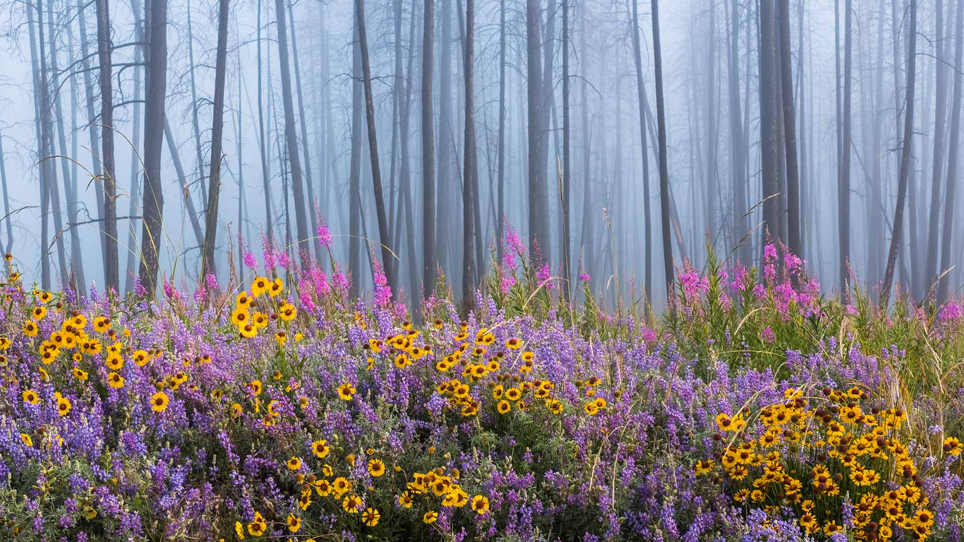
火灾烧毁大部分森林后,野花遍地的凯尔特河野营地 Kettle River Recreation Area bursting with wildflowers after a fire destroyed much of the forest, British Columbia, Canada (© Debra Brash/plainpicture)
Rising from the ashes
This dazzling display of colorful wildflowers is a result of a wildfire that raged through the forest here in British Columbia’s Kettle River Recreation Area. Wildfires in forests are natural and vital to the ecosystem. The heat from the burning tree dumps millions of seeds on the forest floor. Decaying flora turned into ash, releases nutrients in the soil which in turn invigorates the growth of new seedlings. The raging fire further contributes to an abundant new growth of plant matter by eliminating weeds and invasive insects. It also thus makes way for sunlight to immerse the forest floor enabling seeds to germinate and eventually bloom into a scene like our homepage today.
辛华达瀑布,加拿大贾斯珀国家公园 Sunwapta Falls in Jasper National Park, Alberta, Canada (© Schroptschop/Getty Images)
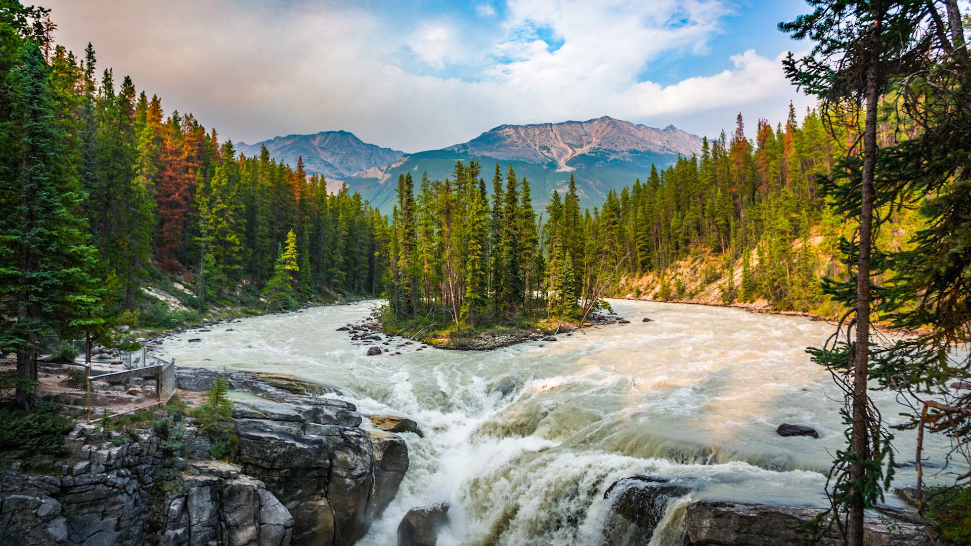
辛华达瀑布,加拿大贾斯珀国家公园 Sunwapta Falls in Jasper National Park, Alberta, Canada (© Schroptschop/Getty Images)
Falling for the Canadian Rockies
Sunwapta Falls is one of several waterfalls in Jasper National Park in Alberta, Canada, formed by hanging valleys. These valleys were created 8,000 years ago when glacier ice receded. Sunwapta Falls is actually a pair of waterfalls, a lower and upper one. Their water comes from the Athabasca Glacier, so volumes are higher in the summer due to seasonal glacial melting. Jasper National Park is the largest national park in the Canadian Rockies, with more than 4,000 square miles for camping, hiking, water sports, and other activities. Wildlife in the park includes elk, grizzly bears, moose, bighorn sheep, and caribou.
瓦普斯克国家公园内向洞穴外张望的北极熊幼崽,加拿大马尼托巴 Polar bear cubs looking out of their den in Wapusk National Park in Manitoba, Canada (© Robert Harding/Alamy)
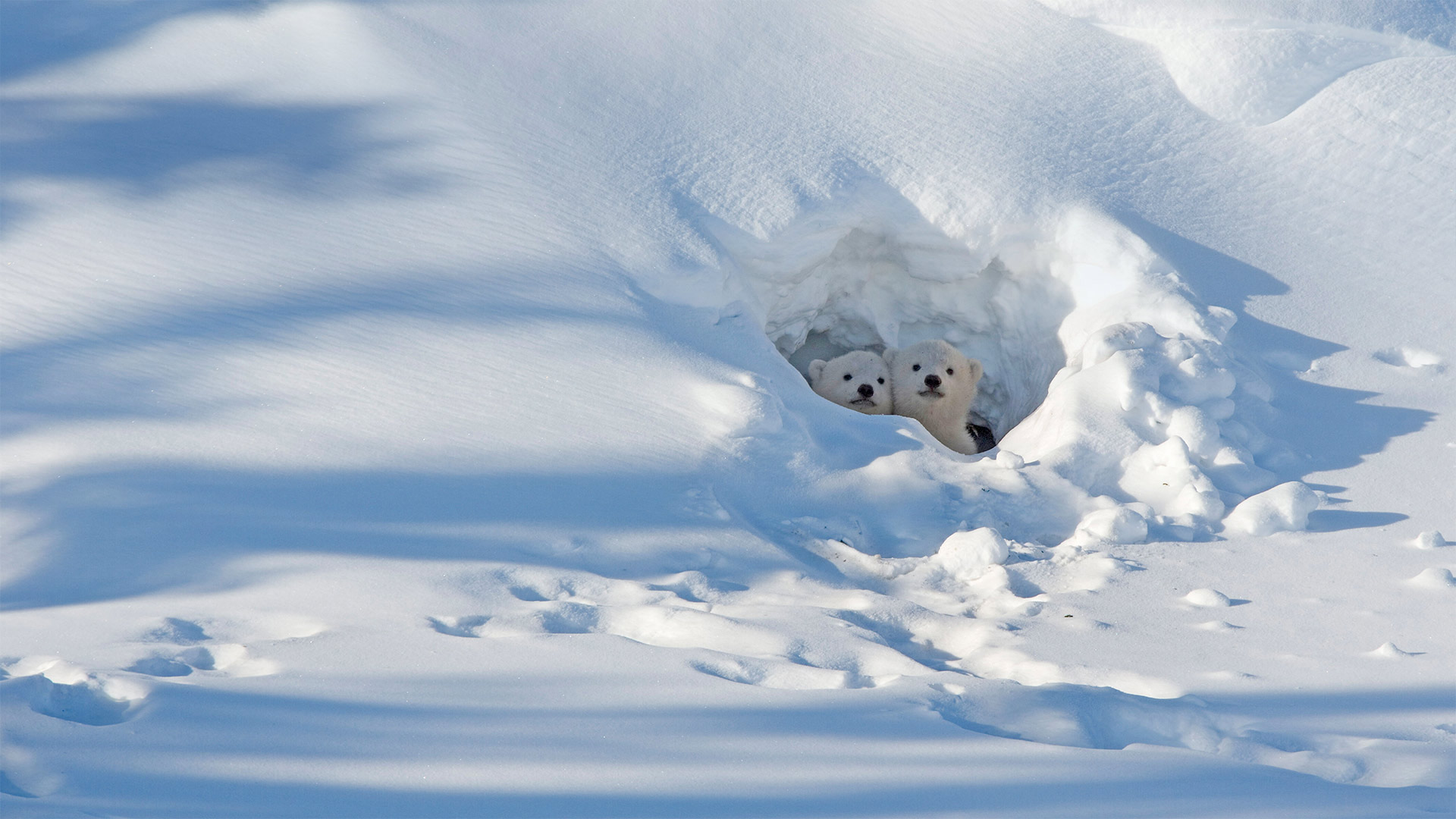
瓦普斯克国家公园内向洞穴外张望的北极熊幼崽,加拿大马尼托巴 Polar bear cubs looking out of their den in Wapusk National Park in Manitoba, Canada (© Robert Harding/Alamy)
Anybody out there?
This is the time of year that polar bears emerge from their winter dens. In today's photo, these adorable cubs are peeking out for the first time in their young lives. Polar bears don't technically hibernate, but in fall, a pregnant female polar bear will dig a maternity den in the snow (although in some areas it'll be under the peat soil). While in her small den, the bear enters a dormant state, sleeping nearly all the time, until she gives birth, usually between November and February. Then, in spring she'll dig herself out and emerge with her recently arrived cubs. Polar bear cubs stay with their mother for about two years as they learn to survive in the Arctic.
The cubs in this photo are in Wapusk National Park in Manitoba, Canada, which is known as the 'Polar Bear Capital of the World.' It's one of the best places to see polar bears in their natural environment—especially when they move there in the fall, waiting for Hudson Bay to freeze before heading out to hunt for seals.
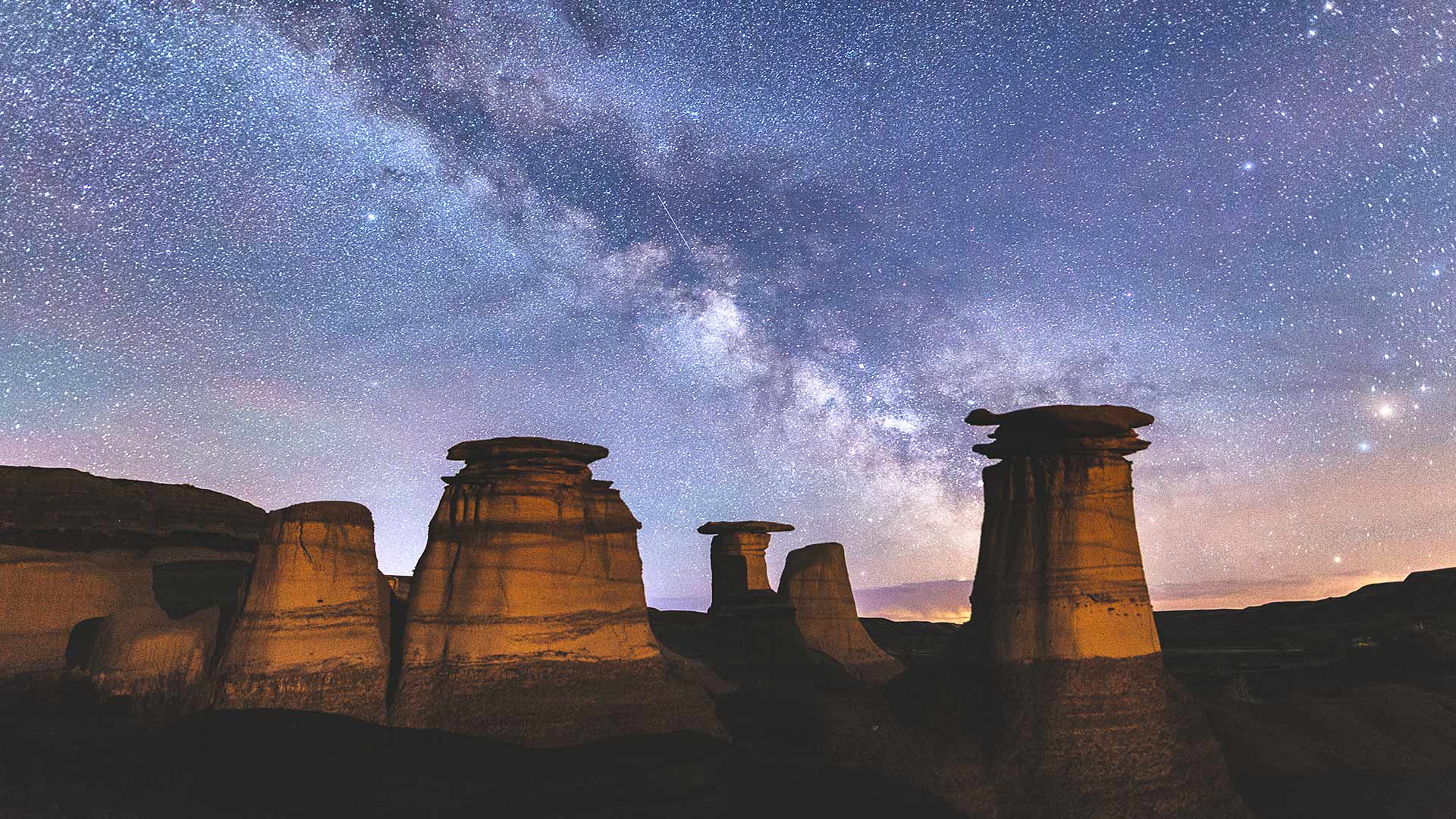
加拿大恶地里石窟上方的银河,加拿大亚伯达省德拉姆黑勒 (© Felis Images/Minden Pictures)
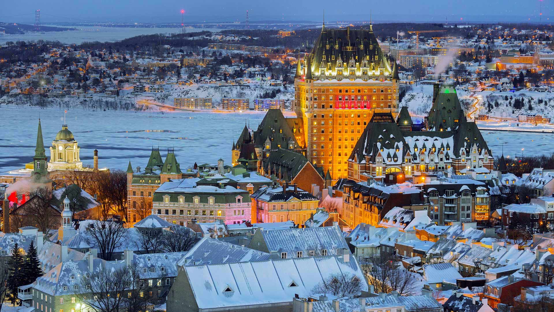
魁北克老城区的景色,加拿大 View of the Old City in Quebec City, Canada (© RENAULT Philippe/age fotostock)
魁北克老城区的景色,加拿大 View of the Old City in Quebec City, Canada (© RENAULT Philippe/age fotostock)
Frozen fun in the Canadian cold
Not far downriver from Montreal, where the banks of the St. Lawrence River widen as it approaches the Atlantic, lies Quebec's picturesque and often chilly capital. Quebec City, one of the continent's oldest European settlements, is often called the most European city outside Europe. It's the only North American city outside Mexico whose fortified walls still stand, and its winding streets showcase a French-tinged exemplar of old Romantic architecture (typified by the steep-roofed Château Frontenac in the photo's foreground).
The mid-sized metropolis has been central to French Canadian life for over 400 winters, and the annual Quebec Winter Carnival—which kicks off today—is one of the largest and oldest cold-weather celebrations on Earth. Thousands of Quebecers and visitors will spend the next 10 days ice skating, enjoying night parades, exploring the festival's ice palace, and dressing up for the Château's masquerade ball. A few will even perform winter feats like the ice canoe race, where boaters pilot specially-equipped canoes across the freezing St. Lawrence, intermittently stepping out to carry their vessels over huge ice chunks.