布莱顿-霍夫被雪覆盖的海滩小屋,英国 Beach huts covered in snow in Brighton and Hove, England (© Tim Jones/Alamy)
布莱顿-霍夫被雪覆盖的海滩小屋,英国 Beach huts covered in snow in Brighton and Hove, England (© Tim Jones/Alamy)
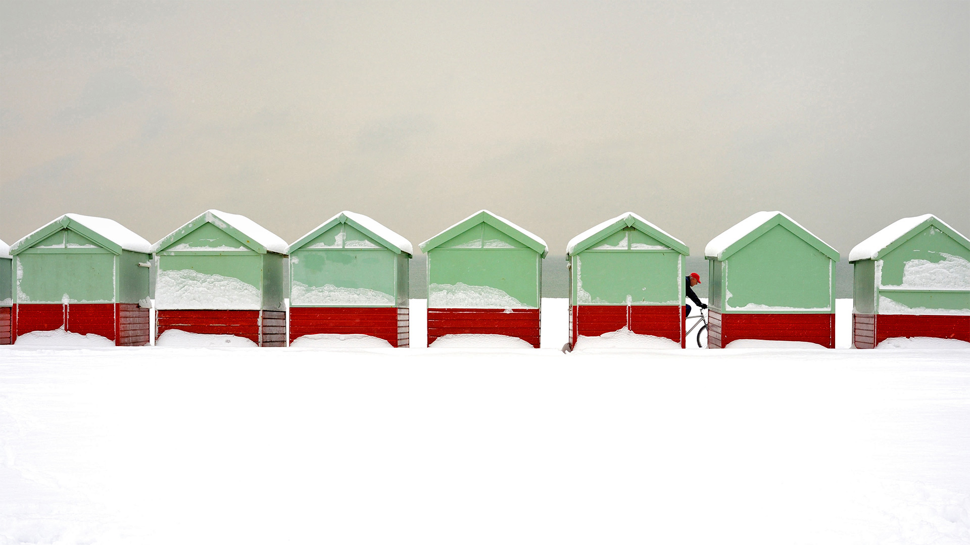
Summer huts in winter
We're getting chilly just looking at these snow-covered beach huts in England—and that cyclist slogging through the white stuff. But in the summer, these huts in Brighton and Hove (neighboring towns that share a local government) are in major demand. You can't stay in them overnight, but they give you a place to change your clothes and stash your belongings, which makes a day at the beach less messy and generally more pleasant. The seaside resort area is also known for attractions like Brighton Palace Pier, which offers rides and fast food, and the i360 tower, which takes visitors 450 feet up for a 360-degree view across Brighton, the South Downs, and English Channel.
冬季夏季小屋
我们刚看到英格兰的这些积雪覆盖的海滩小屋,和骑自行车的人在白色的东西中艰难前行,就觉得很冷。但到了夏天,布莱顿和霍夫(与当地政府合用的邻近城镇)的这些棚屋需求量很大。你不能在里面过夜,但他们会给你一个地方换衣服和存放物品,这会让你在沙滩上的一天不那么凌乱,总体上也会更愉快。海滨度假区也以景点而闻名,如布莱顿宫码头,提供乘车和快餐,i360塔,游客可以在450英尺高的地方360度俯瞰布莱顿、南唐斯和英吉利海峡。
多佛尔白崖,英国多佛尔 White Cliffs of Dover, England (© LisaValder/Getty Images)
多佛尔白崖,英国多佛尔 White Cliffs of Dover, England (© LisaValder/Getty Images)
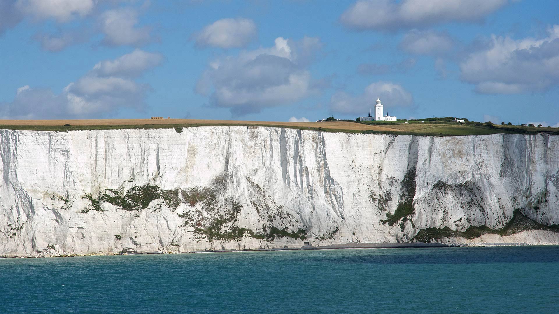
Of balloons and lost pantaloons
We all fly by the seat of our pants now and then, but how about flying with no pants at all? That was the plight of Jean-Pierre Blanchard and John Jeffries, who on January 7, 1785, made history over these chalk cliffs with the first aerial crossing of the English Channel. When their hydrogen-filled balloon dropped altitude due to overloading, the two tossed all the cargo they could into the drink below, britches included. Reaching France in their underpants, the undoubtedly chilly pilots still received a warm welcome.
Known worldwide as an emblem of England, the White Cliffs of Dover rise 350 feet over the strait where Blanchard and Jeffries made their crossing. The white chalk and gray-black streaks of flint match geologically with shorter cliffs on the French side—evidence of a land bridge that existed long before we primates got the notion to fly. Of course, even soaring over the waves is a bit outmoded now that you can zip under them in the Channel Tunnel, which has its entrance just down the coast.
气球和丢失的裤子
我们通常都穿着裤子坐在自己的座位上飞行,但是不穿裤子飞行怎么样?这就是让-皮埃尔·布兰查德和约翰·杰弗里斯的困境,1785年1月7日,他们第一次飞越英吉利海峡,在白垩悬崖上创造了历史。当他们的充氢气球因超载而下降高度时,两人把所有能装的货物都扔进下面的饮料里,包括裤子。穿着内裤到达法国,这些毫无疑问冷冰冰的飞行员仍然受到热烈欢迎。
全世界都知道多佛的白色悬崖是英格兰的象征,在布兰查德和杰弗里斯穿越的海峡上空350英尺高。白色的白垩和灰黑色的燧石条纹在地质学上与法国一侧较短的悬崖相吻合,这是早在我们灵长类动物有飞行的概念之前就存在的陆桥的证据。当然,即使是在海浪上翱翔也有点过时了,现在你可以在海峡隧道里滑行,它的入口就在海边。
凯西克附近的Castlerigg石圈,英国坎布里亚 Castlerigg Stone Circle near Keswick, Lake District, Cumbria, United Kingdom (© Alan Copson/plainpicture)
凯西克附近的Castlerigg石圈,英国坎布里亚 Castlerigg Stone Circle near Keswick, Lake District, Cumbria, United Kingdom (© Alan Copson/plainpicture)
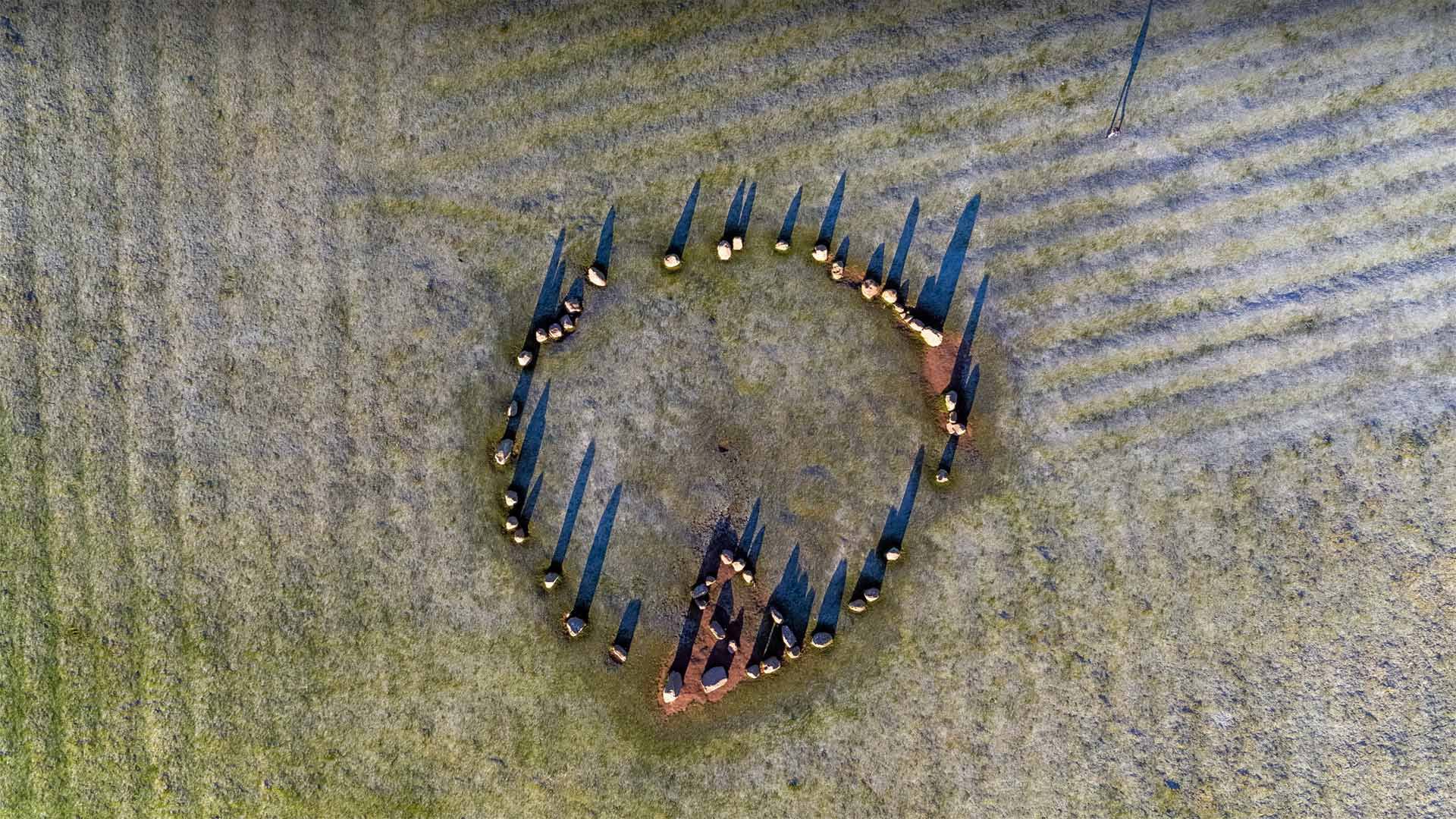
Older than Stonehenge?
Roughly 5,000 years ago, ancient inhabitants of the British Isles somehow dragged as many as 40 giant stones—the heaviest weighing an estimated 16 tons—onto this grassy plateau in what is now England's Lake District National Park in Cumbria. They then grouped them into the stone circle at Castlerigg, seen here casting shadows from the low winter sun. Archeologists believe stone circles, were arranged to align with solar and lunar positions. They were used in elaborate rituals to celebrate occasions like today's winter solstice, the shortest day (and longest night) of the year in the Northern Hemisphere.
Castlerigg is believed to be one of the oldest of the approximately 1,300 stone circles in Britain. And while it's not as well-known as Stonehenge—which was probably begun soon after Castlerigg—its panoramic views of the neighboring Blencathra, Helvellyn, and Skiddaw mountains make it one of the most scenic. Even today, Castlerigg draws winter solstice revelers who beat drums and participate in the magical festival of Yule, in which a log is burned to symbolize the return of heat and light to the sun. And for those of you lamenting the short, cold days of winter, you can take some comfort in knowing that after today the hours of daylight will steadily lengthen, and in six months we'll have traded positions with the Southern Hemisphere and will enjoy long, warm days once again.
比巨石阵还要古老?
大约5000年前,不列颠群岛的古代居民不知何故把多达40块巨石(最重的一块估计重达16吨)拖到了现在位于坎布里亚的英格兰湖区国家公园的这片草地上。他们聚集在这里,在这里能看到低落的冬日阳光中投射的阴影。考古学家认为,石圈是按照太阳和月球的位置排列的。它们被用于精心的仪式来庆祝像今天冬至,这是北半球一年中最短的一天(和最长的夜晚)。
卡斯特里格被认为是英国约1300个石圈中最古老的一个。虽然它不像巨石阵(巨石阵可能是在卡斯特罗里格之后不久开始建造的)那么出名,但它能看到邻近的布兰卡斯特拉、赫尔维林和斯基德道山脉的全景,这使它成为风景最优美的地方之一。即使是在今天,卡斯特雷格也吸引了冬至狂欢者,他们敲锣打鼓,参加尤勒的神奇节日,在那儿燃烧一根原木,象征着阳光和热量回归太阳。对于那些哀叹冬天短而寒冷的日子的人,您可以放心一些,因为他们知道今天以后的日照时间将稳步延长,并且在六个月内我们将与南半球进行交易,并享受长期,温暖的日子再次出现。
德文特湖上的德文特岛房屋,英国坎布里亚郡湖区国家公园 Derwent Island on Derwentwater in the Lake District National Park, Cumbria, England (© Chris Warren/eStock Photo)
德文特湖上的德文特岛房屋,英国坎布里亚郡湖区国家公园 Derwent Island on Derwentwater in the Lake District National Park, Cumbria, England (© Chris Warren/eStock Photo)
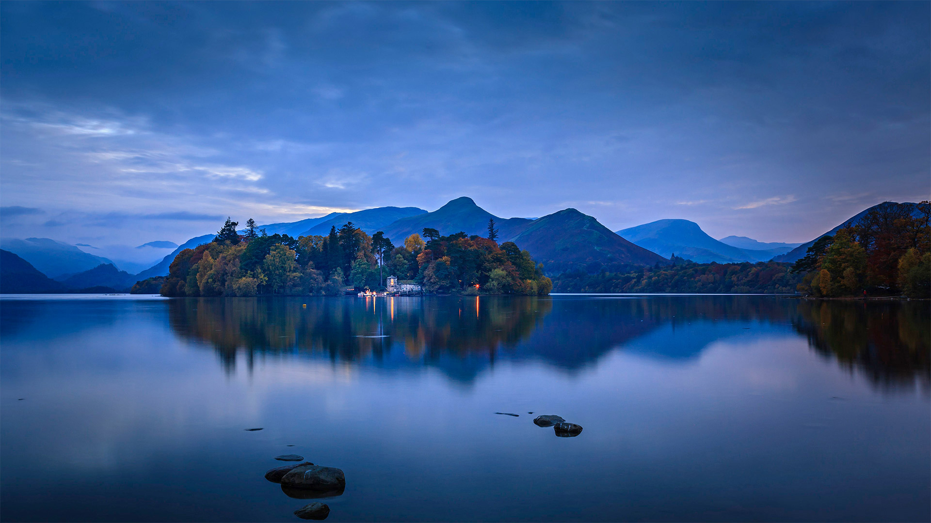
Languid life on the Lakes
Surrounded not only by the spectacular fells (moors) and pikes (peaks) seen here on the horizon but also lush, rolling farmlands, the lake known as Derwentwater is one of more than 30 bodies of water in North West England's Lake District. Rounder and broader in shape than its fingerlike brethren, Derwentwater is home to several small isles like this one—though the classical estate built here is an unusual interruption of this mostly-natural tableau.
We're seeing the island's boathouse, one of several buildings that a wealthy eccentric named Joseph Pocklington had erected shortly after his 1778 purchase of the island. The main building, Derwent Island House, is set out of view farther back on the woody isle. The estate once included a stone fort housing a cannon, often fired to incite playful 'raids' on the island during regattas Pocklington hosted each year on the lake. Critics of old—among them poet William Wordsworth, who famously loved the Lakes—decried Pocklington's additions as eyesores, but modern-day visitors gladly line up to visit the Italianate estate on the five days a year that it's open to the public.
从奎雷英山口看到的 Leum na Luirginn湖和Cleat湖,英国斯凯岛 Loch Leum na Luirginn and Loch Cleat seen from the Quiraing, Isle of Skye, Scotland, UK (© Sebastian Wasek/Sime/eStock Photo)
从奎雷英山口看到的 Leum na Luirginn湖和Cleat湖,英国斯凯岛 Loch Leum na Luirginn and Loch Cleat seen from the Quiraing, Isle of Skye, Scotland, UK (© Sebastian Wasek/Sime/eStock Photo)
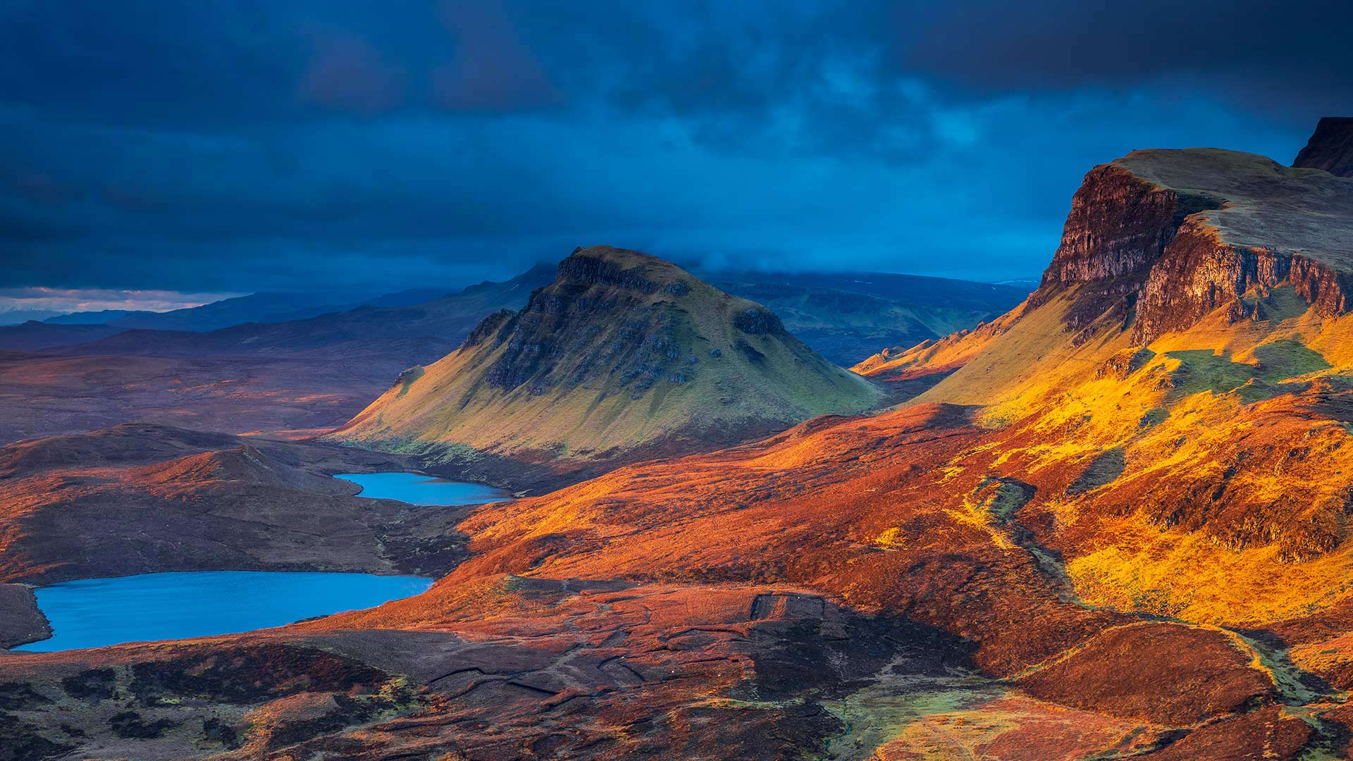
The sliding landscape of Skye
As the sun rises on the Isle of Skye, off Scotland’s west coast, it casts a golden glow on a landscape shaped by lava flows, erosion and glacial movement. An ancient landslip here runs for nearly 20 miles, creating a labyrinth of steep slopes, hidden plateaus and dramatic rock formations.
This particular section is known as the Quiraing and it is the only bit of the landslip which is still moving, albeit by just a few centimetres a year. Among numerous striking rock formations are a 120ft pinnacle known as The Needle and The Prison, an outcrop that looks like a medieval fortress. The Quiraing’s name is derived from the Old Norse ‘Kvi Rand’ (meaning round fold) and it is said that another local landmark, an elevated grassy plateau known as The Table, was used to hide cattle from Viking raiders.
The Quiraing’s sweeping panoramas make it a favourite with photographers and walkers, while various movies including Transformers: The Last Knight and 47 Ronin have also featured scenes from this fantastical landscape.
科夫堡,英国多塞特 Corfe Castle, Dorset, England (© Ross Hoddinott/Minden Pictures)
科夫堡,英国多塞特 Corfe Castle, Dorset, England (© Ross Hoddinott/Minden Pictures)
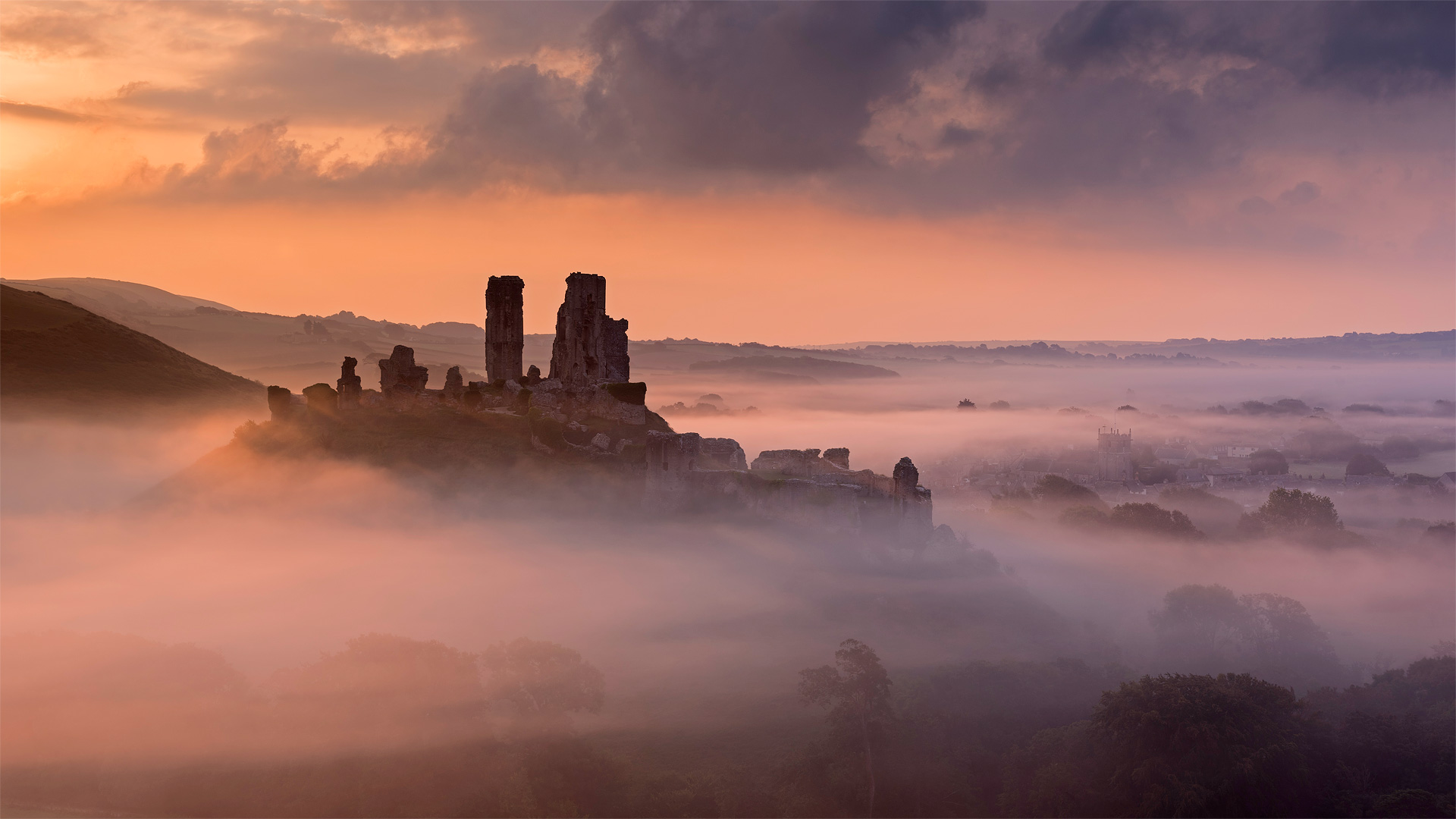
Creepy Corfe Castle
Spying the crooked silhouette of Corfe Castle above the rolling, foggy hills of Dorset, you might not guess at the ruin's former palatial beauty—you'll more likely sense its long history of intrigue, and maybe feel a chill down your spine.
Corfe's tale begins with a betrayal. Rumor has it this mound is where the teenage King Edward the Martyr was assassinated, likely by his half-brother and successor Æthelred the Unready, in 978—a century before the original stone structure was built. The castle became a favorite of 13th-century ruler King John—whose luxurious renovations hid a feared dungeon where the calculating monarch starved numerous prisoners. In the mid-1600s English Civil War, noblewoman Mary Bankes—wife of the castle's new lord, who was off fighting the war—doggedly defended it against antiroyalist forces in a 3-year siege. But Mary was given up by members of her entourage and captured, and the castle was toppled into the craggy heap you see now—another betrayal to end its story.
Nowadays the remains of Corfe Castle are preserved as a Scheduled Ancient Monument by the UK—but that status might not be all that's protecting the site. Reports of children's sobs echoing through the air, unexplained flickering lights, and—most notoriously—the headless apparition of a white-clad woman have some believing specters of a millennium past still haunt the ruin.
Restormel城堡上空的秋雾,英国康沃尔 Autumn mist above Restormel Castle in Cornwall, England (© Robert Harding/Alamy)
Restormel城堡上空的秋雾,英国康沃尔 Autumn mist above Restormel Castle in Cornwall, England (© Robert Harding/Alamy)
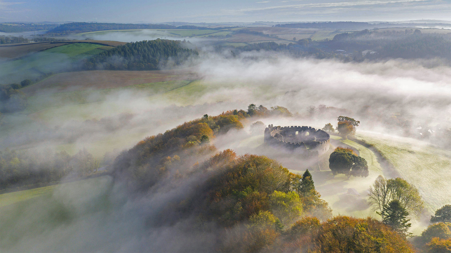
The circular castle of Cornwall
Many generations watched fog roll over this countryside long before the bellicose Norman visitors who built this fortress got the chance. The peninsula of Cornwall has been populated since the Mesolithic period 10,000 years ago, and is one of the traditional Celtic nations—areas of the British Isles and France where the Celts' culture survived Roman, Norman, and other outside influences despite repeated attempts at incursion.
Restormel Castle is one of the best-preserved keeps of its era in the UK, and also stands apart for its rare rotund shape. Built by the conquering Normans in the wake of their 1066 invasion of Britain, it was fortified as a perfect stone circle a hundred years later. Soon it was renovated into a luxurious palace with rudimentary plumbing and coveted hunting grounds. But after centuries of off-and-on use, it fell into disrepair after the English Civil War ended in 1651. It was acquired by the British government in the early 20th century. Open to the public, Restormel is now managed by the English Heritage charity trust.
斯塔德兰附近荒野上丛生的紫色和粉红色帚石楠,英国多塞特郡 (© allou/iStock/Getty Images Plus)
The Giant's Causeway, Bushmills, Northern Ireland, UK (© Chiara Salvadori/Getty Images)
The Giant's Causeway, Bushmills, Northern Ireland, UK (© Chiara Salvadori/Getty Images)
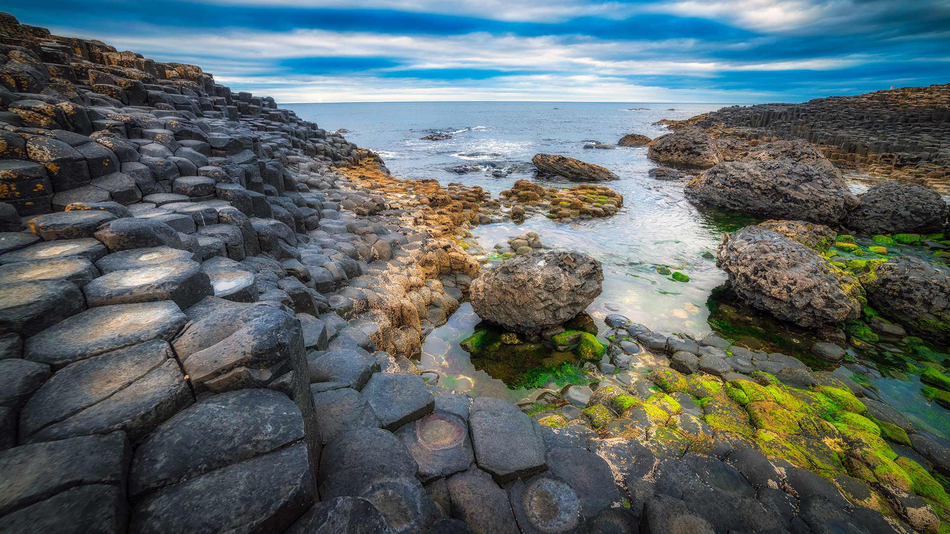
In the footsteps of giants.
Let's follow in the footsteps of giants, this is one of the most popular tourist attractions in Northern Ireland. The Giant's Causeway is an area of about 40,000 interlocking basalt columns, the result of an ancient volcanic fissure eruption. It was declared a World Heritage Site by UNESCO in 1986 and a national nature reserve in 1987 by the Department of the Environment for Northern Ireland. The tops of the columns form stepping stones that lead from the cliff foot and disappear under the sea. Most of the columns are hexagonal, although there are also some with four, five, seven, or eight sides. The tallest are about 12 meters (39 ft) high, and the solidified lava in the cliffs is 28 meters (92 ft) thick in places.
Infinity Bridge in Stockton-on-Tees, England (© Robert Smith/Alamy)
Infinity Bridge in Stockton-on-Tees, England (© Robert Smith/Alamy)
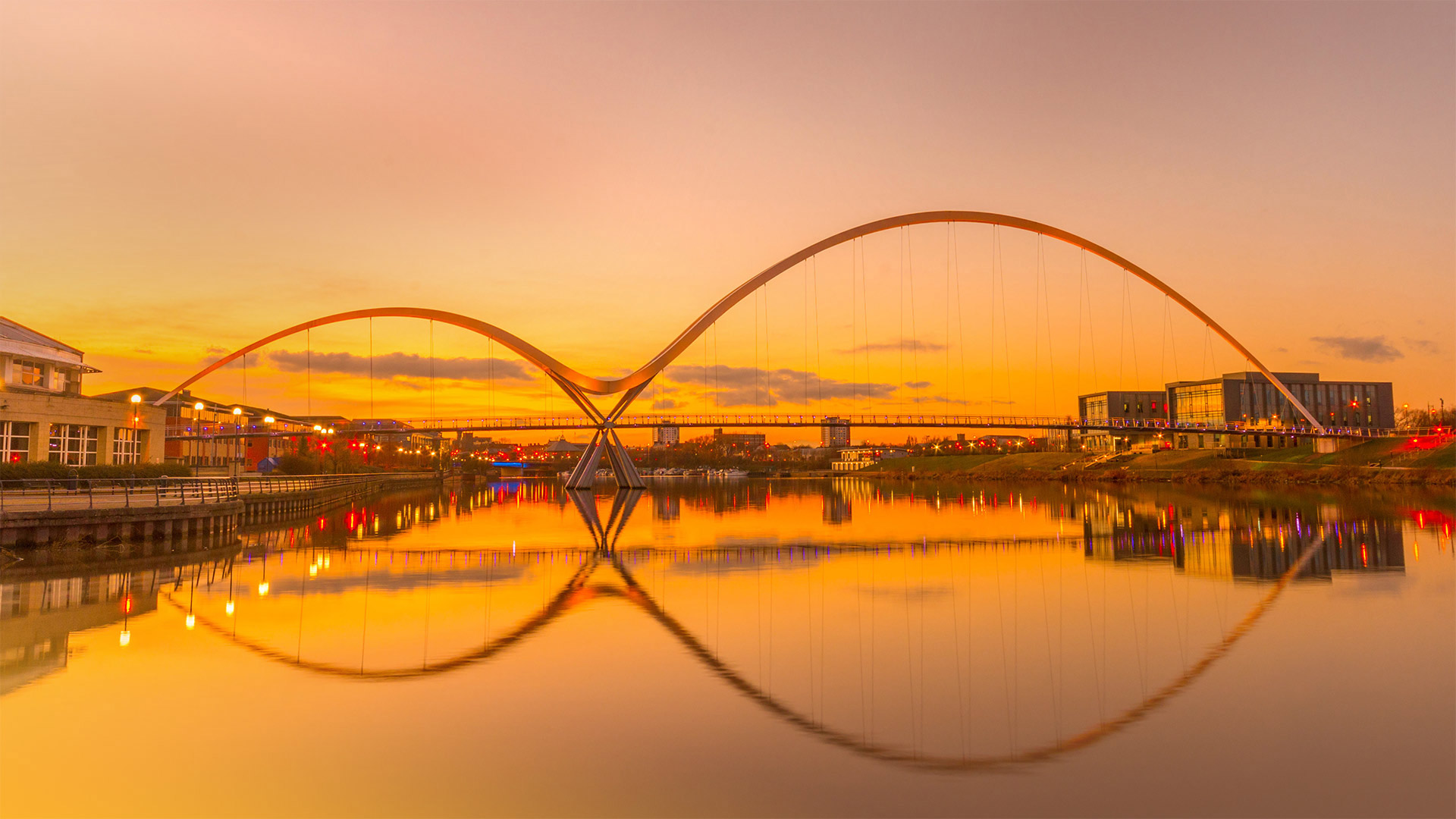
It's ∞ Day!
Gustave Flaubert wrote that 'an infinity of passion can be contained in one minute.' So, if you have boundless passion for contemplating the immeasurable, a full day should offer plenty of time. August 8 (8/8) is Infinity Day since the numeral 8 looks like a tilted ∞, the common symbol for infinity first popularized in 17th-century math books. But the concept of infinity itself represents an idea much older, inherent in the countless spiritual traditions that revere eternal gods or outline endless life cycles.
The bridge in today's image, which carries foot and bike traffic over the River Tees in North East England, wasn't designed with the infinite in mind. But denizens of Stockton-on-Tees thought the tilted figure-eight created by the reflected swooping structure was reminiscent enough of the infinity symbol that city leaders applied the name Infinity Bridge upon the bridge's 2008 completion.