屋前的鲜花和铁艺围栏,路易斯安那州新奥尔良 Flowers and ironwork fence in front of a house in New Orleans, Louisiana (© Lauren Mitchell/Offset by Shutterstock)

屋前的鲜花和铁艺围栏,路易斯安那州新奥尔良 Flowers and ironwork fence in front of a house in New Orleans, Louisiana (© Lauren Mitchell/Offset by Shutterstock)
Mardi Gras flower power
While the purple flowers and green ironwork may not look overly festive to the untrained eye, residents of New Orleans will no doubt spot the significance of both, especially today, on Mardi Gras, the final day of Carnival. Purple and green are two of the three official colors of Mardi Gras, together with gold, and in a normal year the streets would be full of revelers decked out in all three colors as they dance and parade down the streets of the city. Due to COVID-19, there won't be any parades this year, but the colors will still be on full display in the city's famous French Quarter and elsewhere, including as colorful icing atop king cakes, a beloved treat that's associated with the Carnival season.
The colors themselves have officially been part of Mardi Gras since 1872, when they were introduced by the newly formed Krewe of Rex, one of the private social clubs ('krewes') that stage parades and other Carnival festivities. The krewe's ceremonial King of Carnival ('Rex') proclaimed that gold represents power, green represents faith, and purple stands for justice.
The ironwork seen here is a characteristic feature of homes and buildings in the region. It traces back to the early 18th century, when slaves and freemen from West Africa, influenced by French and Spanish styles, crafted fences, gates, and railings from cast iron. The often elaborately ornamented designs adorn verandas and balconies, giving residents a pleasant place to cool off in the muggy Louisiana heat. In true New Orleans fashion, even the architecture reflects a blend of cultural influences that make the city so wonderful and unique.
狂欢节花的力量
虽然紫色的花朵和绿色的铁艺在未经训练的人看来可能不会显得过于喜庆,但新奥尔良的居民无疑会发现两者的意义,尤其是今天,在狂欢节的最后一天——狂欢节。紫色和绿色是狂欢节的三种官方颜色中的两种,再加上金色,在正常年份,街道上会挤满穿着这三种颜色的狂欢者,他们在城市的街道上跳舞游行。由于COVID-19,今年将不会有任何游行,但颜色仍将在该市著名的法国区和其他地方充分展示,包括作为国王蛋糕上的彩色糖衣,这是一种与狂欢节相关的受人喜爱的待遇。
自1872年起,颜色本身就正式成为狂欢节的一部分,当时新成立的雷克斯克鲁俱乐部(Krewe of Rex)推出了这种颜色,这是一家私人社交俱乐部(“krewes”),负责举办游行和其他狂欢节。克鲁的嘉年华仪式之王(“雷克斯”)宣称,黄金代表权力,绿色代表信仰,紫色代表正义。
这里看到的铁制品是该地区住宅和建筑的一个特色。它可以追溯到18世纪初,当时来自西非的奴隶和自由人受法国和西班牙风格的影响,用铸铁制作栅栏、大门和栏杆。这些经常精心装饰的设计装饰在阳台和阳台上,给居民一个舒适的地方在闷热的路易斯安那州凉爽。在真正的新奥尔良时尚,甚至建筑反映了文化的影响,使城市如此美妙和独特的融合。
安加白令嘉河与诺朗加港,南澳大利亚州 Onkaparinga River, Port Noarlunga, South Australia (© plainpicture/AWL/Marco Bottigelli)
安加白令嘉河与诺朗加港,南澳大利亚州 Onkaparinga River, Port Noarlunga, South Australia (© plainpicture/AWL/Marco Bottigelli)
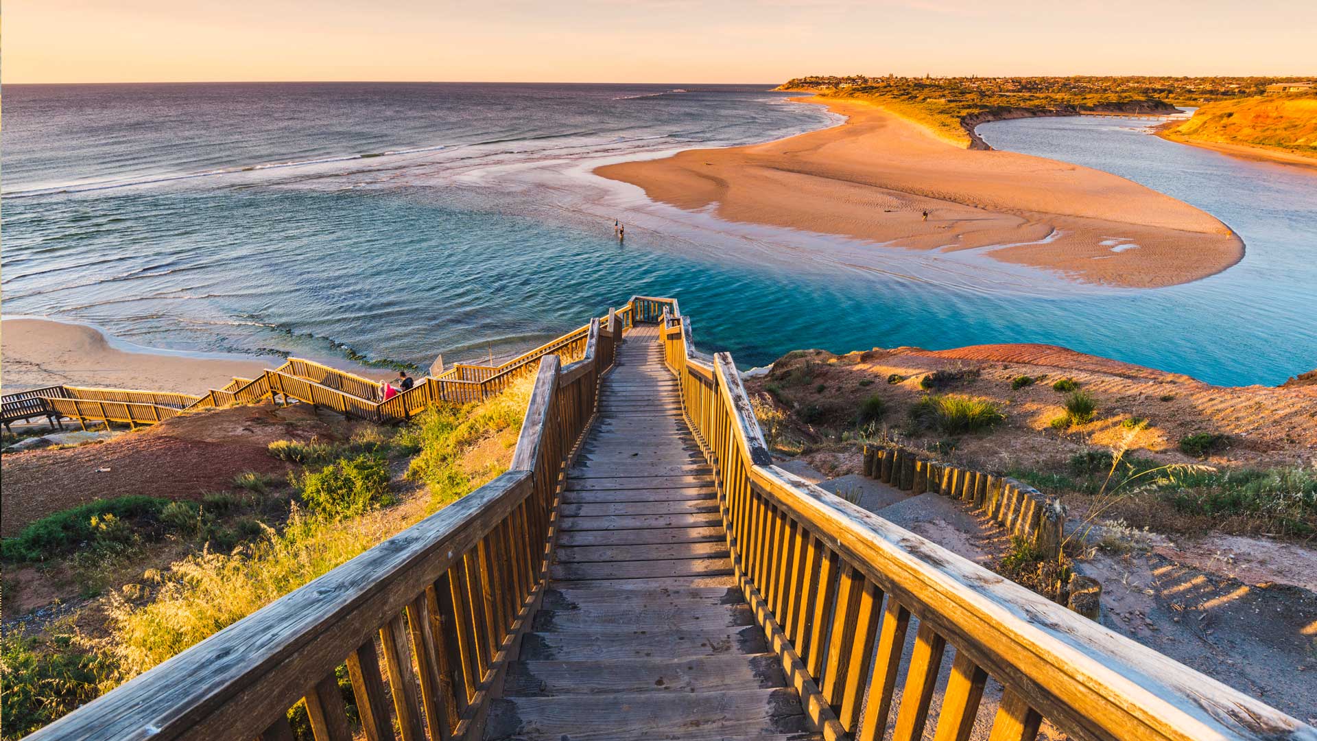
Stairway to heaven?
Where does this seemingly endless staircase lead? To the mighty Onkaparinga River, of course – a true South Australian highlight. The river itself is crucially important to the area’s ecosystem, acting as a beautiful home to a variety of fish that breed here, as well as hundreds of native plants and animal species. The Onkaparinga River estuary is even seen a habitat for endangered migratory birds.
It’s also a great place for us humans to visit as well. Between both Onkaparinga River Recreation Park and Onkaparinga River National Park there is no shortage of activities to take part in or sights to see. Many locals often stroll along the wetland boardwalks, hike up to the cliff tops or find a cosy spot to camp the night. If the weather is as stunning as is looks in today’s image, kayaking is also a popular choice – providing the perfect opportunity to escape the hustle and bustle of life. Sounds peaceful, doesn’t it?
通往天堂的阶梯?
这看似无尽的楼梯通向何方?到浩瀚的翁卡帕林加河,当然-一个真正的南澳大利亚亮点。这条河本身对该地区的生态系统至关重要,是这里繁殖的各种鱼类以及数百种本地动植物的美丽家园。Onkaparinga河口甚至被视为濒危候鸟的栖息地。
这也是一个伟大的地方,我们人类参观以及。在昂卡帕林加河休闲公园和昂卡帕林加河国家公园之间,不乏可参加的活动或可观赏的景点。许多当地人经常沿着湿地木板路漫步,徒步走上悬崖顶,或者找个舒适的地方过夜。如果天气像今天的图片一样令人惊叹的话,皮划艇也是一个流行的选择——提供了一个逃离生活喧嚣的绝佳机会。听起来很平静,不是吗?
海浪冲击着悉尼海岸的一个心形岩石岛,澳大利亚 Ocean waves crashing over a heart-shaped rock island off the coast of Sydney, Australia (© Kristian Bell/Getty Images)
海浪冲击着悉尼海岸的一个心形岩石岛,澳大利亚 Ocean waves crashing over a heart-shaped rock island off the coast of Sydney, Australia (© Kristian Bell/Getty Images)
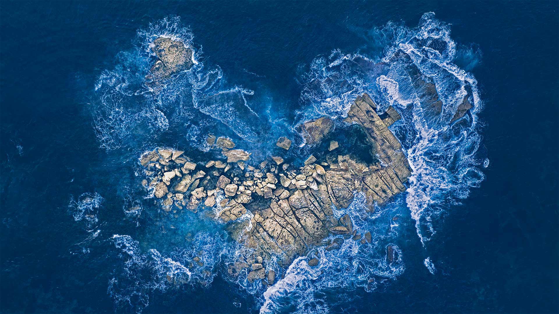
An oceanic Valentine
Just off the coast of Sydney, in New South Wales, Australia, the surf crashes over this cluster of rocks, sending an oceanic Valentine's Day card to a lucky bird—or photographer—flying overhead. We'll take nature's love letters wherever and whenever we can find them. But what makes February 14 the day we celebrate love? Some claim Valentine's Day has its roots in an ancient Roman fertility festival called Lupercalia that included goat sacrifices and a lottery that paired off eligible men and women. Others argue that the holiday began with Christians celebrating a martyr named Valentine. Chaucer romanticized the day with a poem about two birds mating for life. No matter its pagan or Christian origins, in the modern world, Valentine's Day is celebrated most everywhere as a day devoted to love.
海洋情人节
就在澳大利亚新南威尔士州悉尼海岸附近,海浪冲过这片岩石群,给头顶飞过的幸运鸟或摄影师送去了一张海洋情人节贺卡。无论何时何地,我们都会带着大自然的情书。但是,是什么让2月14日成为我们庆祝爱情的日子呢?有人说情人节起源于古罗马的生育节,叫做Lupercalia,包括山羊祭祀和抽奖,抽奖的对象是符合条件的男女。另一些人则认为,这个节日始于基督徒庆祝一位名叫瓦伦丁的烈士。乔叟用一首关于两只鸟一生交配的诗把这一天浪漫化了。无论是异教或基督教的起源,在现代世界,情人节是庆祝作为一个致力于爱的日子最无处不在。
拍摄于俄勒冈州海岸拥抱点瀑布的幻月 (© Ben Coffman/Tandem Stills + Motion)

奥拉基库克山国家公园中的塞夫顿山,新西兰南岛 Mount Sefton in Aoraki/Mount Cook National Park, South Island, New Zealand (© AWL Images/Danita Delimont)

奥拉基库克山国家公园中的塞夫顿山,新西兰南岛 Mount Sefton in Aoraki/Mount Cook National Park, South Island, New Zealand (© AWL Images/Danita Delimont)
Where is this gorgeous peak?
This spectacular landscape might just be the perfect place to celebrate Waitangi Day, New Zealand's national holiday. It commemorates the 1840 treaty between Britain and some 500 Māori chiefs that established British law in the island nation. The Treaty of Waitangi is considered New Zealand's founding document and a cornerstone in the country's history. Another important legacy of the treaty is that it provided the framework for political relations between New Zealand's government and the indigenous Māori people.
Perhaps nothing symbolizes negotiations between those two parties better than the land you see here, which has been preserved as a national park since 1953. Our image shows the glacier-capped peak of Mount Sefton, one of the many tall mountains here in the Southern Alps. Just a few miles away towers New Zealand's tallest peak, originally called Aoraki by the Māori, who named it after a mythological figure. The mountain was given its English name, Mount Cook, in 1851, in honor of Captain James Cook, the British explorer who circumnavigated and mapped the country in the 1770s. An agreement in 1998 between the government and Māori leaders officially renamed both the peak and the park to Aoraki/Mount Cook. It's one of the few renamed areas in New Zealand where the Māori name precedes the English.
这座美丽的山峰在哪里?
这片壮观的风景可能正是庆祝新西兰国庆日怀唐日的最佳场所。它纪念1840年英国与大约500名毛利人酋长签订的条约,该条约确立了英国在这个岛国的法律。《怀唐伊条约》被认为是新西兰的创始文件和国家历史的基石。该条约的另一个重要遗产是,它为新西兰政府与土著毛利人之间的政治关系提供了框架。
也许没有什么比你在这里看到的这块土地更能代表两党之间的谈判了,这块土地自1953年以来一直被保留为国家公园。我们的图片显示了塞夫顿山冰川覆盖的山峰,它是阿尔卑斯山脉南部众多高山之一。就在几英里远的地方,矗立着新西兰最高的山峰,毛利人最初称之为Aoraki,以一个神话人物的名字命名。1851年,为了纪念英国探险家詹姆斯·库克上尉(James Cook),这座山被命名为库克山(Mount Cook),詹姆斯·库克上尉于1770年代环游并绘制了该国地图。1998年,政府与毛利人领导人达成协议,正式将山顶和公园更名为Aoraki/Mount Cook。这是新西兰为数不多的几个更名地区之一,毛利人的名字先于英语。
波浪谷中的砂岩层和积水,亚利桑那州朱红悬崖国家纪念碑 Sandstone formation and pools of water in 'The Wave,' Paria Canyon-Vermilion Cliffs National Monument, Arizona (© Dennis Frates/Alamy)

波浪谷中的砂岩层和积水,亚利桑那州朱红悬崖国家纪念碑 Sandstone formation and pools of water in 'The Wave,' Paria Canyon-Vermilion Cliffs National Monument, Arizona (© Dennis Frates/Alamy)
A sea of swirling stone
By showing you this coveted sight, we're saving you a bit of an ordeal. For close-up view like this of 'The Wave,' a whorled sandstone formation in the northern Arizona wilderness, you'd have to navigate a rugged and mostly trail-free route with a permit in your pocket (only a small number are available, offered via a daily lottery). But that's just one day hike of many in the expansive Vermilion Cliffs National Monument, which encompasses almost 300,000 acres of Arizona and Utah canyonland.
漩涡石海
通过向你展示这令人垂涎的景象,我们给你省了一点痛苦。像这样近距离观看“海浪”是亚利桑那州北部荒野的一个螺纹砂岩地层,你必须在口袋里带着许可证(只有很少的一部分是可用的,通过每天的抽奖提供)在崎岖不平且几乎没有踪迹的路线上航行。但这仅仅是许多人在广阔的朱红悬崖国家纪念碑上一天的徒步旅行,这座纪念碑覆盖了亚利桑那州和犹他州近30万英亩的峡谷。
北孚日地区自然公园,法国 Northern Vosges Regional Nature Park, France (© Michel Rauch/Minden Pictures)
北孚日地区自然公园,法国 Northern Vosges Regional Nature Park, France (© Michel Rauch/Minden Pictures)
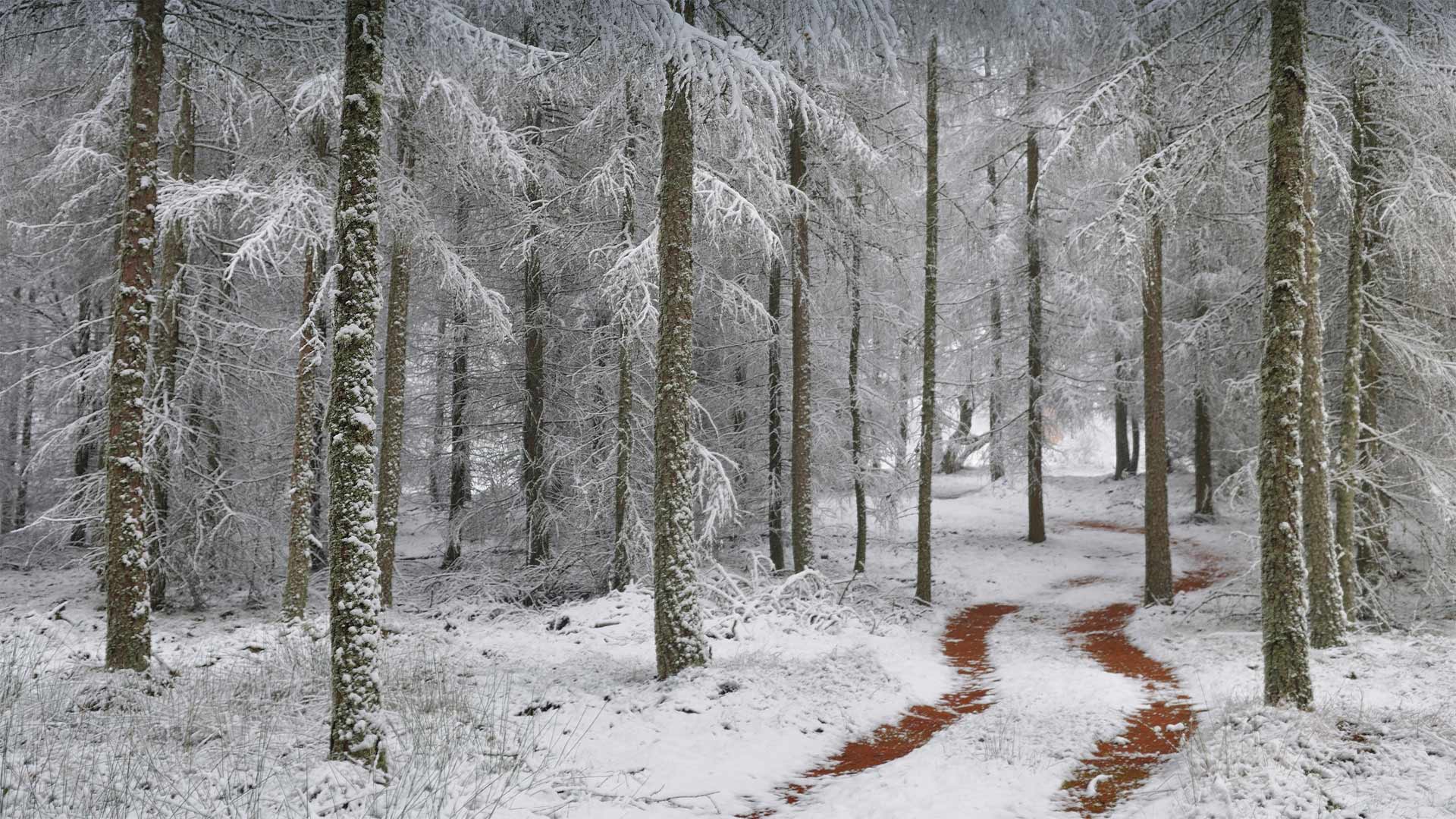
Where is this wintry road?
This wintry, wooded scene comes from the Northern Vosges Regional Nature Park in northeastern France, one of the country's most beautiful and pristine examples of natural beauty. The park, established in 1976, is over 322,000 acres in size, 65% of which is covered in forest, including the species of larch tree seen here. These larches are native to many of the mountains of central Europe, such as the Alps, Carpathians, and the Pyrenees.
Even though the area here is dotted with villages, because so much of its natural beauty remains, this rural park was named by UNESCO as one of its World Biosphere Reserves. UNESCO studies these reserves to trace the interaction between social systems and the natural world. This biodiversity of the Northern Vosges includes a wide array of forests and wetlands, fauna and flora, but also contains over 100 municipalities, farmlands and even five structures left over from France's infamous WWII-era Maginot Line of fortifications built to deter invading German forces. With its many hiking trails, the Northern Vosges region is a favorite for outdoor enthusiasts and nature lovers.
这条冬天的路在哪里?
这个寒冬里树木繁茂的场景来自法国东北部的北部沃斯地区自然公园,这里是法国最美丽和最原始的自然美景之一。这个公园建于1976年,占地32.2万英亩,其中65%被森林覆盖,包括这里看到的落叶松。这些落叶松原产于中欧的许多山脉,如阿尔卑斯山、喀尔巴阡山和比利牛斯山。
尽管这里到处都是村庄,但由于保留了太多的自然美景,这个乡村公园被联合国教科文组织命名为世界生物圈保护区之一。联合国教科文组织对这些保护区进行研究,以追踪社会系统与自然世界之间的相互作用。这种生物多样性的北部沃斯包括广泛的森林和湿地,动植物群,但也包含了100多个城市,农田,甚至还包括法国二战时期臭名昭著的马其诺线遗留下来的防御工事,目的是阻止入侵的德国军队。北沃斯地区有许多徒步旅行路线,是户外爱好者和自然爱好者的最爱。
内姆鲁特山上巨大的石灰岩雕像,土耳其阿德亚曼 Colossal limestone statues on Mount Nemrut, Adıyaman, Turkey (© Peerakit JIrachetthakun/Getty Images)
内姆鲁特山上巨大的石灰岩雕像,土耳其阿德亚曼 Colossal limestone statues on Mount Nemrut, Adıyaman, Turkey (© Peerakit JIrachetthakun/Getty Images)
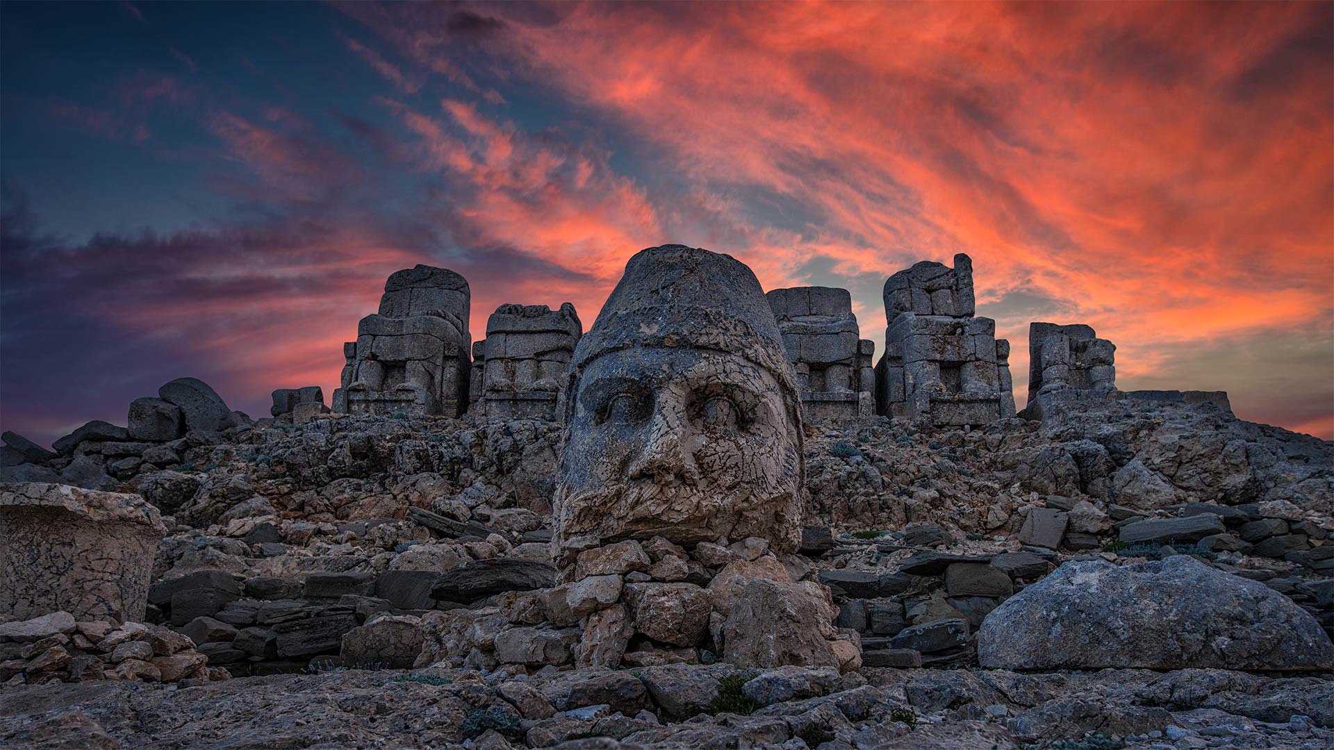
The mountaintop of toppled gods
The ruins on Mount Nemrut depict a gaggle of gods from both Greek and Persian traditions, plus a few deities that King Antiochus I made up himself. The range of spiritual faiths represented in the statues found near the 7,000-foot summit reflects southeastern Turkey's long history as a crossroads of cultures. Today, the derelict statues are protected as a UNESCO World Heritage Site.
In 70 BCE, Antiochus took power here in Commagene, one of several small onetime states formed from the shambles of the Seleucid Empire. Looking to unify his populace, he synthesized a mythology that hailed Greek and Persian figures, from Ares to Zarathustra—plus the king himself and his family. Antiochus' claim to godhood wasn't eternal, as he was deposed in 31 BCE, but sometime before that he cemented his customized state religion in history by having its partial pantheon—including, of course, himself—carved into stone statues on the peak overlooking his kingdom.
被推翻的神的山顶
涅姆鲁特山上的废墟描绘了希腊和波斯传统的众神,加上安提约克一世国王自己创造的一些神。在7000英尺高的山顶附近发现的雕像所代表的各种精神信仰反映了土耳其东南部作为文化交汇点的悠久历史。今天,这些被遗弃的雕像被联合国教科文组织列为世界遗产。
公元前70年,安提约克在科马根尼掌权,科马根尼是塞琉西帝国废墟中形成的几个小国家之一。为了统一他的人民,他合成了一个神话,颂扬希腊和波斯的人物,从阿瑞斯到查拉图斯特拉,再加上国王本人和他的家人。安提约克对神性的要求并不是永恒的,因为他在公元前31年被废黜,但在此之前的某个时候,他通过拥有部分万神殿(当然包括他自己)在俯瞰王国的山顶上雕刻成石像,巩固了他定制的国教在历史上的地位。
日落后的托莱多全景,西班牙 Panoramic view of the city of Toledo after sunset, Spain (© Frank Fischbach/Alamy)
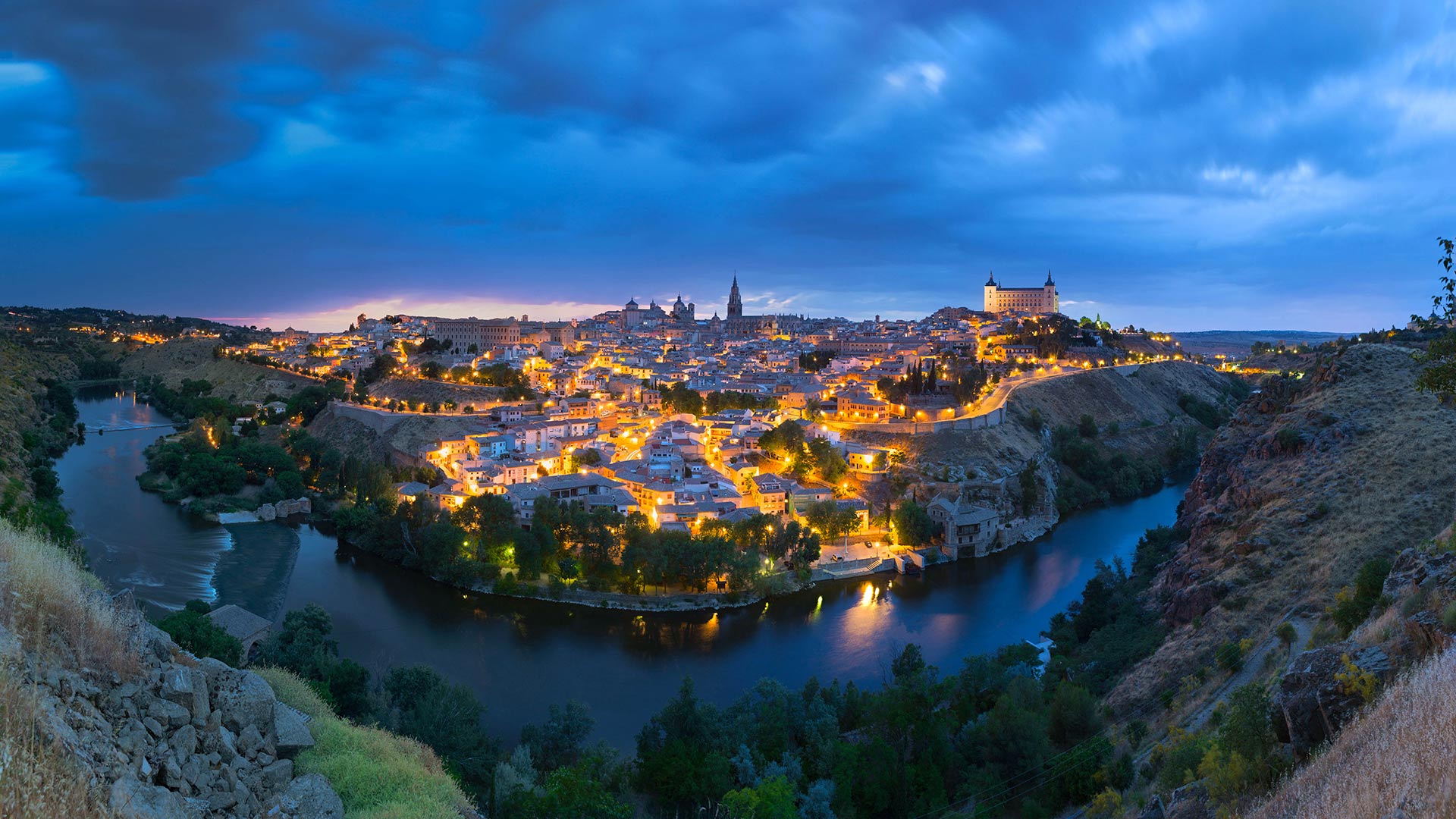
日落后的托莱多全景,西班牙 Panoramic view of the city of Toledo after sunset, Spain (© Frank Fischbach/Alamy)
Desde la otra orilla del Tajo
The image that we offer you today is the panoramic view of the old town that can be seen from the viewpoint of the Valley, on the other bank of the Tagus. To the right is the Alcázar, one of the most representative buildings in the city, with the Gothic cathedral of Santa María looming on its left. And a little further on, the Jewish quarter, where among other outstanding buildings you can find El Greco's house.
从塔霍河的另一岸
我们今天提供的图像是老城区的全景,可以从山谷的视角,在塔古斯的另一边看到。右边是阿尔卡扎尔,是城市中最具代表性的建筑之一,左边是圣玛丽亚哥特式大教堂。再远一点,犹太区,在那里,除了其他优秀的建筑,你可以找到埃尔格雷科的房子。
巴伐利亚阿尔卑斯山脉中的米滕瓦尔德小屋,德国 Mittenwalder Hütte in the Bavarian Alps of Germany (© Sebastian Frölich/Offset by Shutterstock)
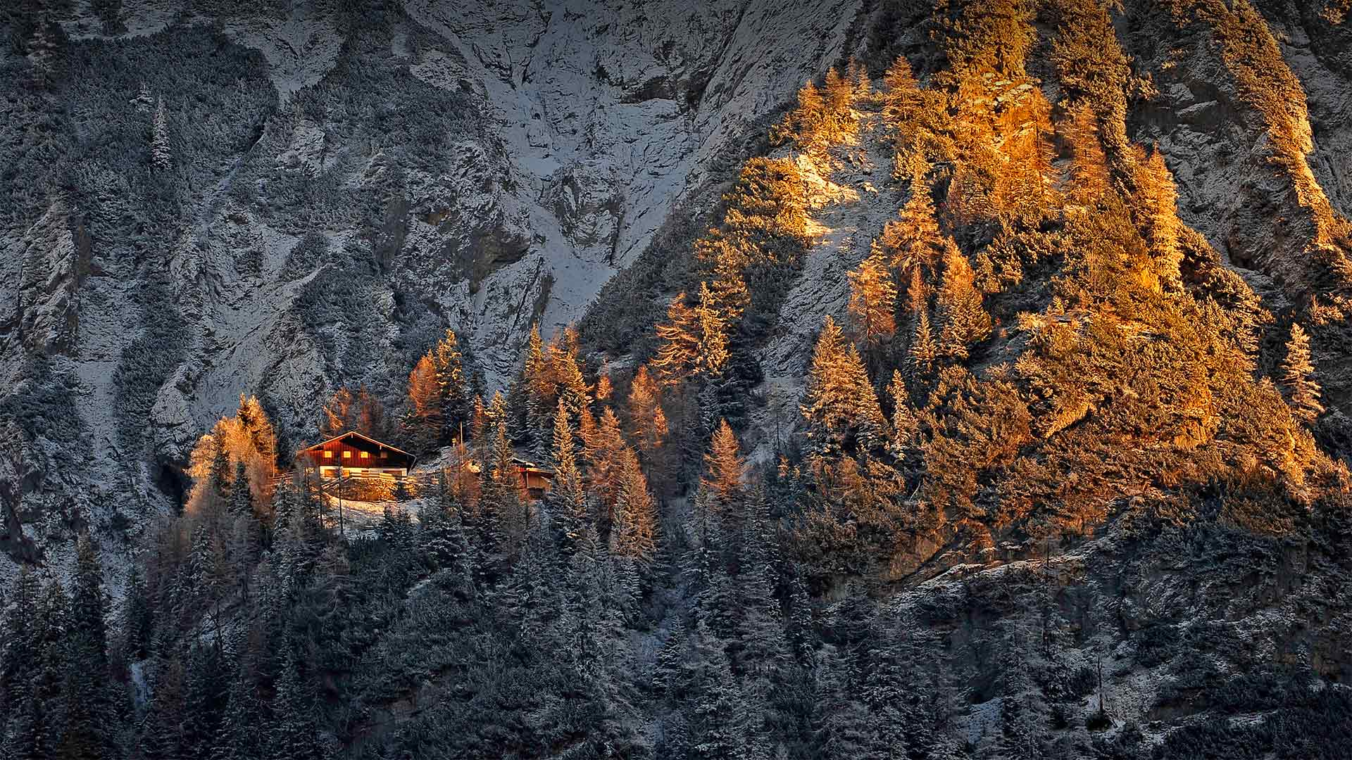
巴伐利亚阿尔卑斯山脉中的米滕瓦尔德小屋,德国 Mittenwalder Hütte in the Bavarian Alps of Germany (© Sebastian Frölich/Offset by Shutterstock)
A glittering diamond in the rough
Peering from this vantage point you may wonder, how in the world could anyone access this hut nestled in the Bavarian Alps? By hiking in, of course. There are well over 1,000 such huts dotting the Alpine landscape throughout Europe, most of them built and maintained by private social clubs devoted to climbing, hiking, and other activities in the mountains. These huts allow hikers to light out onto the extensive trail systems, sometimes for days, while carrying as little gear as possible. No need to pack cooking equipment, tents and sleeping bags when you have guaranteed shelter each night, with dinners, breakfasts, and, if you're lucky, a hot shower, included.
Do pack earplugs and a sleeping bag liner, as most of the beds are lined up next to each other in a dormitory setting. And don't try booking for this time of year. The hiking season in the Bavarian Alps typically begins in mid-May and lasts through the end of October. Weather, and COVID, permitting of course.
原石中闪闪发光的钻石
从这个有利的角度看,你可能会想,世界上怎么会有人能进入这个坐落在巴伐利亚阿尔卑斯山的小屋?当然是徒步旅行。在整个欧洲的阿尔卑斯山上,有1000多个这样的小屋,其中大多数都是由专门从事登山、徒步旅行和其他山区活动的私人社交俱乐部建造和维护的。这些小屋让远足者可以在尽可能少的携带装备的情况下,在广阔的步道系统中轻松行走,有时甚至可以持续数天。如果你保证每晚都有住处,就不需要打包烹饪设备、帐篷和睡袋,包括晚餐、早餐,如果你幸运的话,还可以洗个热水澡。
一定要带上耳塞和睡袋衬垫,因为在宿舍里,大多数床都是并排的。不要在一年中的这个时候预订。巴伐利亚阿尔卑斯山的徒步旅行季节通常从5月中旬开始,持续到10月底。当然,如果天气允许的话。