巨浪冲击着阿斯洛玛尔州立海滩的岩石,加利福尼亚州帕西菲克格罗夫 Huge waves crashing on rocks along Asilomar State Beach, Pacific Grove, California (© Sheila Haddad/Danita Delimont)
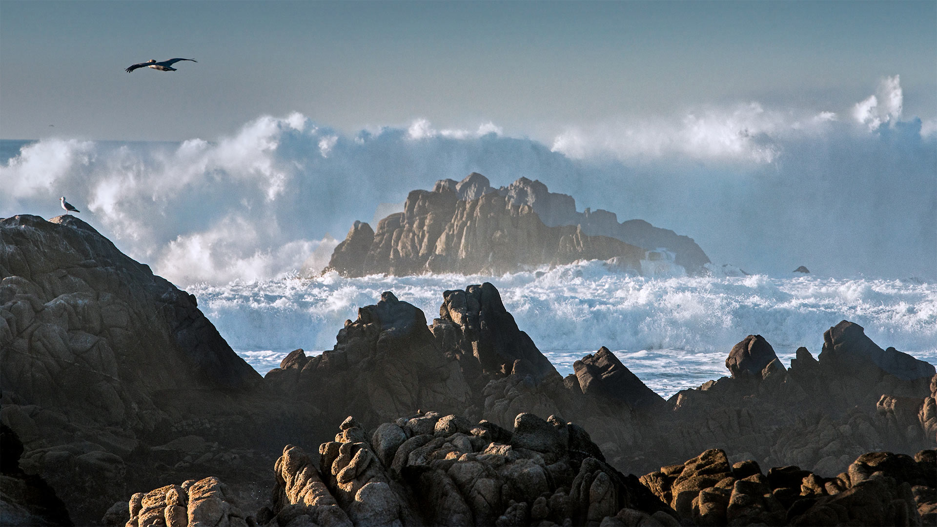
巨浪冲击着阿斯洛玛尔州立海滩的岩石,加利福尼亚州帕西菲克格罗夫 Huge waves crashing on rocks along Asilomar State Beach, Pacific Grove, California (© Sheila Haddad/Danita Delimont)
Feel the spray in Monterey
Fantasizing about warm, sandy beaches with gently lapping waves? Well, we decided you could use a shake-up—so here we are in Monterey County, California, for a glimpse at the ocean's raw, unadulterated power. Asilomar State Beach's mile-long coastline trail offers views like this one of seas crashing on jagged shores. Below the frothy surface swim innumerable ocean organisms protected by the massive Monterey Bay National Marine Sanctuary, the largest marine preserve in the contiguous United States. Behind us, a rich dune habitat supporting its own delicate flora and fauna can be explored via a boardwalk trail.
Andy Goldsworthy's 'Wood Line' installation along Lovers' Lane in the Presidio of San Francisco, California (© Chris LaBasco/Alamy)
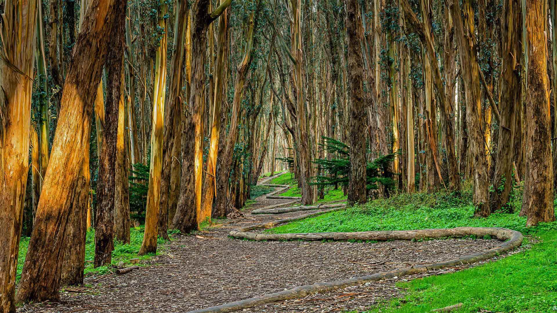
Andy Goldsworthy's 'Wood Line' installation along Lovers' Lane in the Presidio of San Francisco, California (© Chris LaBasco/Alamy)
Take a hike near Lovers' Lane
For those of you who love getting outside, you're in luck! Today is Take a Hike Day, an activity the American Hiking Society says will make you happier as you enjoy the great outdoors. And what better way to take a hike than a walk down Lovers' Lane in San Francisco's Presidio? The sinewy trail we see in today's photo is called 'Wood Line' and was designed by the environmental artist Andy Goldsworthy. By using felled eucalyptus trees, Goldsworthy intended this land art to eventually biodegrade and fade back into the forest floor. It's one of four of his works within this national park that once served as a US military outpost.
No matter where you are, we hope you'll find the closest trail to explore. The US National Trail System maintains more than 55,000 miles of National Scenic, Historic, or Recreational trails through some of the most beautiful, interesting parts of the country, so you have plenty of hikes to choose from.
死亡谷国家公园跑道湖的迷踪石,加利福尼亚 Sailing stone at Racetrack Playa in Death Valley National Park, California (© Patrick Walsh/Getty Images)
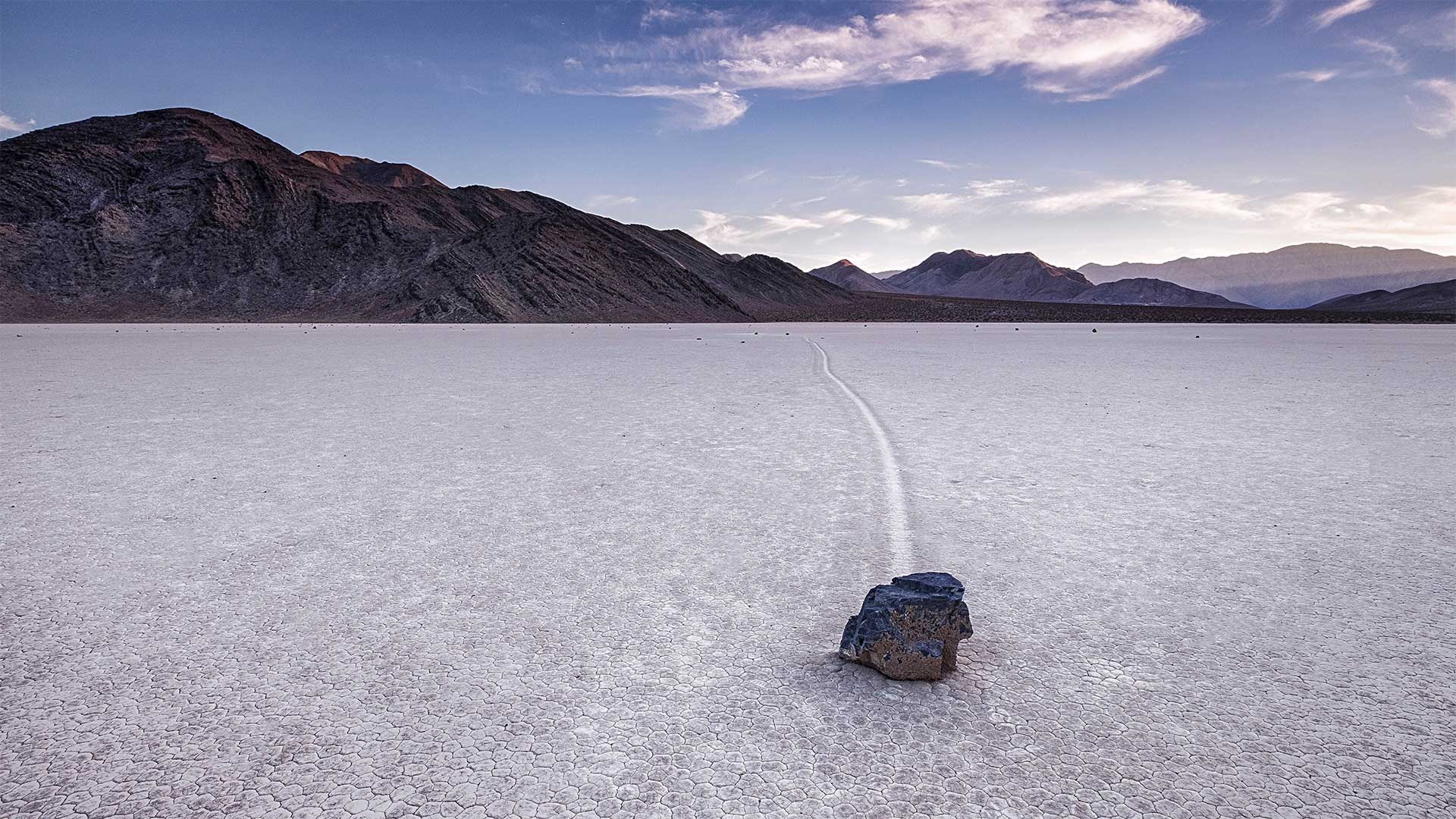
死亡谷国家公园跑道湖的迷踪石,加利福尼亚 Sailing stone at Racetrack Playa in Death Valley National Park, California (© Patrick Walsh/Getty Images)
Rocks on the move
No, that stone in today's homepage image didn't get there by itself. Or, did it? Not only is Death Valley one of the hottest places on Earth, it also boasts a mysterious geologic phenomenon—rocks that drift across the exceptionally flat desert floor, seemingly under their own power. The rocks here at Death Valley's Racetrack Playa are known as 'sailing stones' and they can vary in size from a few ounces to hundreds of pounds. As seen in our image, the stones leave long trails behind them as they move across the scenic dry lakebed.
Since the stone trails were first observed in the early 1900s, no one knew just how the stones managed to have apparently 'sailed' across Racetrack Playa without someone to push them along. Because they'd never been seen moving, the sailing stones gave rise to many wild theories to explain their mobility. Then, in 2014, scientists captured the movement of the stones for the first time using time-lapse photography, and the mystery was finally solved: The stones move only with the perfect balance of melting ice, water, and wind. One day that winter of 2014, rain had formed a shallow pond that froze overnight. When it thawed in the next day's sun, the very thin ice sheet melted and cracked into floating panels. Driven by a light wind, these sheets accumulated behind the stones, and very slowly pushed them forward.
森火山国家公园中的拉森峰,加利福尼亚 Lassen Peak in Lassen Volcanic National Park, California (© Engel Ching/Shutterstock)
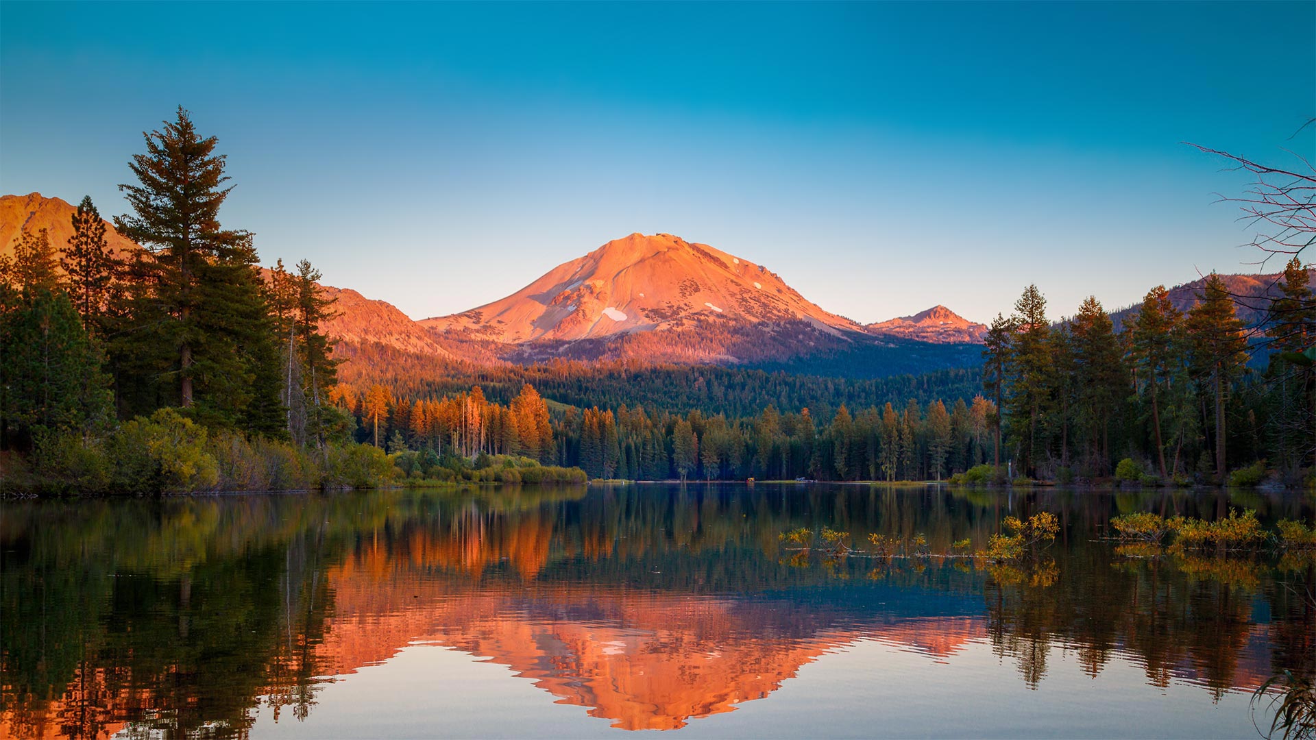
森火山国家公园中的拉森峰,加利福尼亚 Lassen Peak in Lassen Volcanic National Park, California (© Engel Ching/Shutterstock)
A peek at an explosive peak
We're looking at Lassen Peak, a volcano also known as Mount Lassen, and its reflection in Manzanita Lake. This stunning scene can be found in northern California's Lassen Volcanic National Park, which was established on this day in 1916. The volcano erupted between 1914 and 1917 (with some activity as late as 1921), but these days the surrounding area is a calm destination of trails, lakes, and stark lava beds. One of the least visited parks, Lassen was the first national park in California to fully reopen after being closed for COVID-19, although it implemented some restrictions to park services and facilities. The park also includes acres of mud pots, hot springs, steam vents, and fumaroles to remind you of the heat that's below you, including Boiling Springs Lake—one of the largest boiling lakes in the world at over 500 feet wide.
优胜美地国家公园中的春季瀑布 Vernal Fall in Yosemite National Park, California (© elvistudio/Shutterstock)
优胜美地国家公园中的春季瀑布 Vernal Fall in Yosemite National Park, California (© elvistudio/Shutterstock)
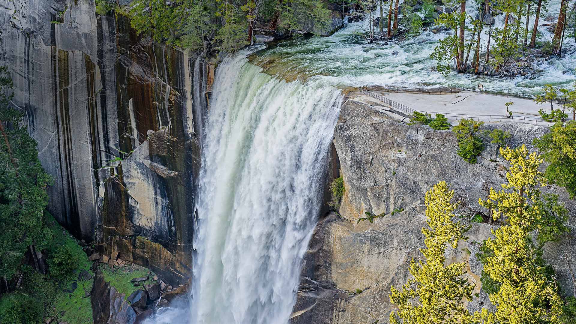
National Parks Week begins
To kick off National Park Week, which starts today, we're turning our lens on Vernal Fall in California's Yosemite National Park. This time of year, the waterfall flows in a torrent, but by late summer it can be reduced to a trickle of small streams slipping over the edge. Most years, Vernal Fall is at full power by May, as the spring thaw in the mountains melts the snowpack, turning the falls into a raging tumble of water spilling to the valley floor where the Merced River flows.
鸟瞰蒙特雷附近的大苏尔海岸线,加利福尼亚州 Aerial view of the Big Sur coastline near Monterey, California (© Blue Planet Archive/Alamy)
鸟瞰蒙特雷附近的大苏尔海岸线,加利福尼亚州 Aerial view of the Big Sur coastline near Monterey, California (© Blue Planet Archive/Alamy)
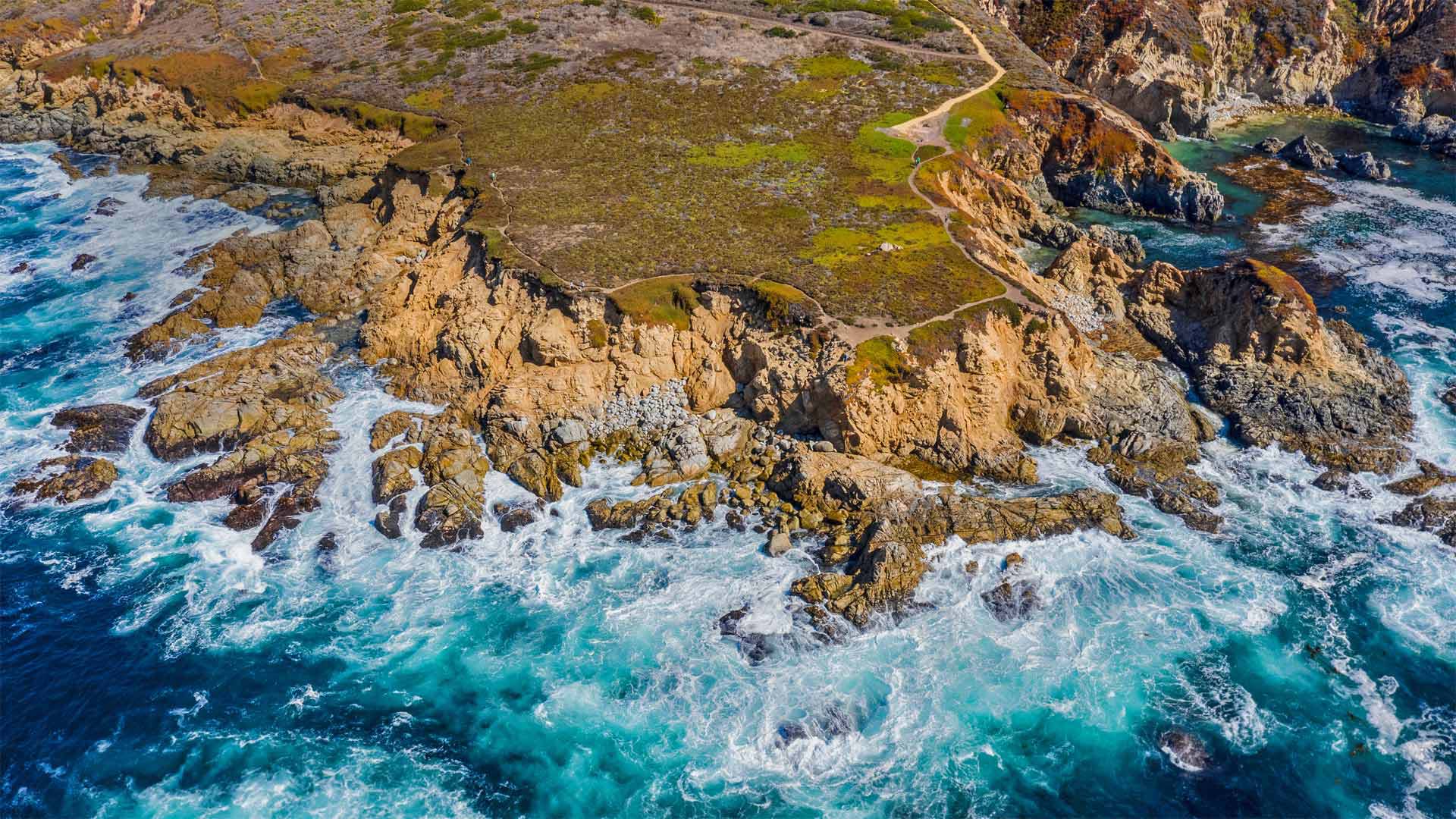
Gray days ahead in Monterey
Grey whale migration is a rare scenery, thousands of gray whales, many with calves in tow, swim by this part of the Pacific coast as they migrate from the warm waters of Baja California to their summer feeding grounds in the Bering Sea. Come winter, they pass by again on the swim south. The entire roundtrip route clocks in at about 12,000 miles, making gray whales among the longest migrators of animal kingdom. Because they travel close to the coastline, it's also one of the few whale migrations you can see from shore.
一只苍鹭栖息在加利福尼亚索尔顿海的木桩上 A heron perches on a piling at the Salton Sea in California (© Garret Suhrie/Cavan Images)
一只苍鹭栖息在加利福尼亚索尔顿海的木桩上 A heron perches on a piling at the Salton Sea in California (© Garret Suhrie/Cavan Images)
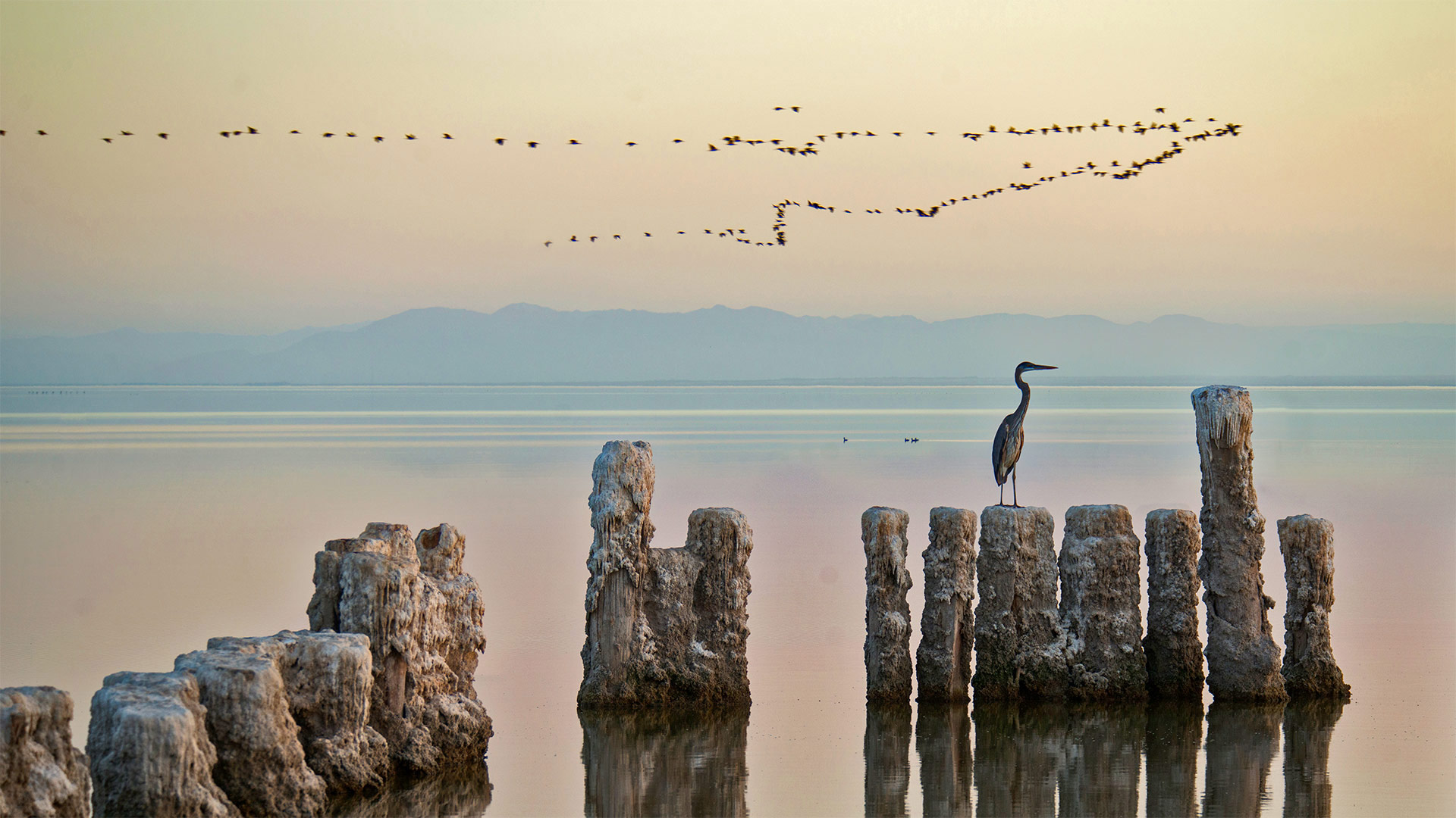
Heron lies the Salton Sea
Migratory bird species are predictable frequent fliers, taking to the sky to travel along roughly the same route, at the same time, every year. Following sources of food and water along the way, the birds often fly great distances to reach breeding grounds or places to spend the winter. Today, we're looking at an important stopover for migratory birds—California's largest lake, the Salton Sea.
This shallow saline lake was formed when a dam broke in 1905, causing the Colorado River to flow into a 35-mile-long basin with extensive salt deposits. Now it attracts hundreds of species of birds in what is considered one of the most significant concentrations of bird life in the continental United States. Most of these birds are just passing through, migrating along the north-south route called the Pacific Flyway. They gather here, sometimes in the millions, to feed and regain strength before moving on. Some birds, like the heron pictured in today's photo, may stay here for the season, but most of those who visit in the spring will stay for just a few days before continuing their journey to a summer spot farther north.
The Hollywood sign overlooking Los Angeles, California (© Sean Pavone/Shutterstock)
The Hollywood sign overlooking Los Angeles, California (© Sean Pavone/Shutterstock)
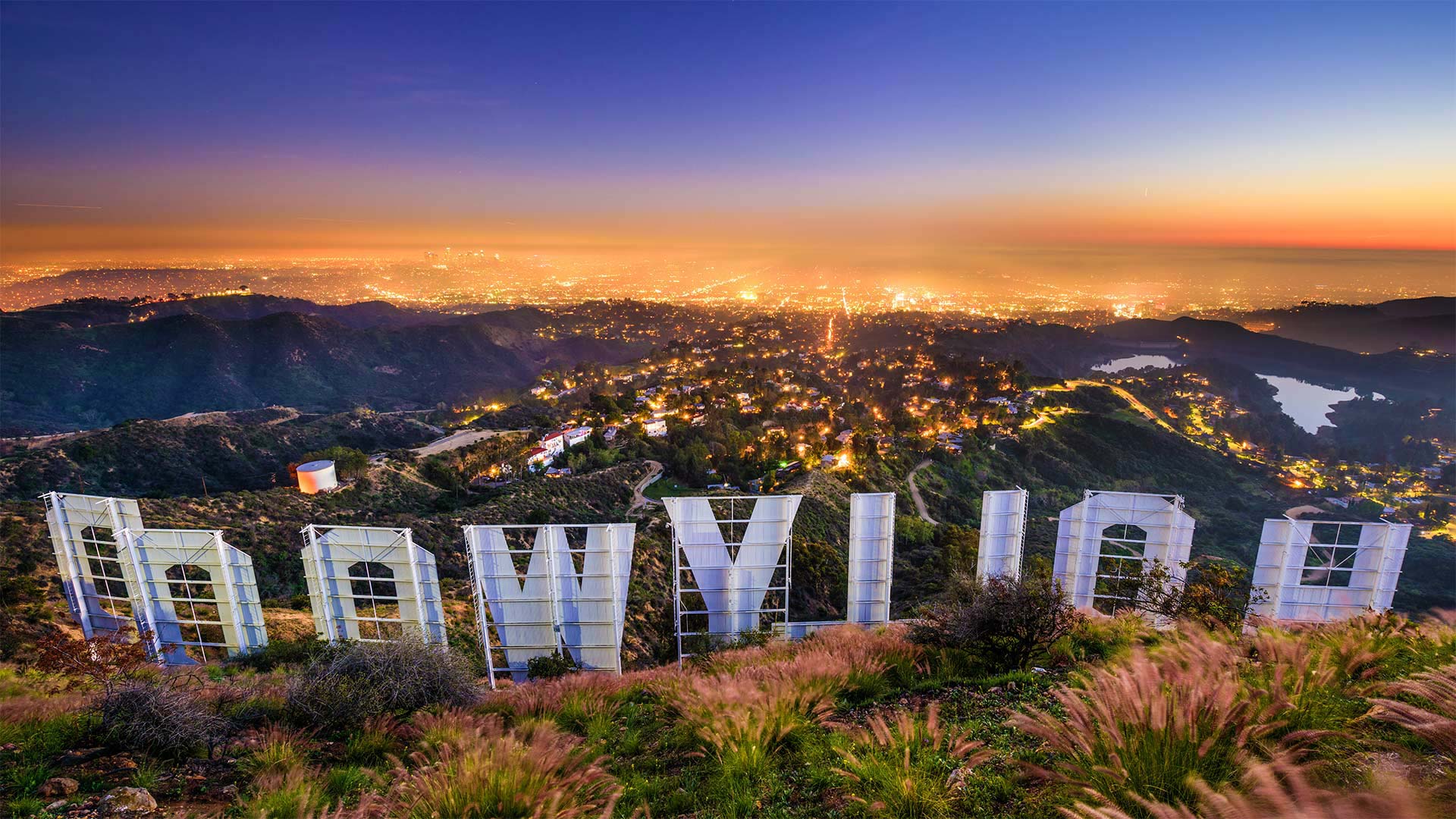
Hollywood's big night
It's Oscars night in Tinseltown, and we're offering you a moment's escape from the paparazzi to gaze over the glittering megalopolis of Los Angeles—and to get an unfamiliar view of a familiar landmark. The Hollywood Sign originally read 'Hollywoodland' when it was erected in 1923 and festooned with light bulbs to advertise a real estate development. But within a few years, as the silent-film era gave way to 'talkies,' the sign evolved into a popular tourist attraction. Falling into disrepair in ensuing decades—at the peak of its decay, the sign was missing its third 'O' altogether—the original was demolished and a sturdier version built in 1978.
Though it's inspired similar designs advertising locales from Ireland to Taiwan to the fictional Simpsons' hometown of Springfield, the now-permanent Hollywood Sign is cherished by residents as uniquely LA. Today, a dedicated nonprofit maintains and promotes the sign as both a source of Angeleno pride and an emblem of romanticized Hollywood.
一只勃兰特鸬鹚在洛杉矶海岸石油钻塔下的一群太平洋鲭鱼中觅食,加利福尼亚 A Brandt's cormorant hunts for a meal in a school of Pacific mackerel beneath an oil rig off the coast of Los Angeles, California (© Alex Mustard/Minden Pictures)

一只勃兰特鸬鹚在洛杉矶海岸石油钻塔下的一群太平洋鲭鱼中觅食,加利福尼亚 A Brandt's cormorant hunts for a meal in a school of Pacific mackerel beneath an oil rig off the coast of Los Angeles, California (© Alex Mustard/Minden Pictures)
A seabird gets 'schooled'
This deep-diving Brandt's cormorant appears to be on the hunt for a meal, and there's plenty of Pacific mackerel to choose from here off the coast of Los Angeles, California. While seabirds like the cormorant are a threat to these fish, the mackerel aren't exactly defenseless. Fish have many unique means of defense, such as traveling in dense schools like this one. It's a technique that not only allows for speedy travel (because it reduces friction on most of the fish in the school)—schooling also makes it more difficult for predators to pick out an individual victim. For these fish, there's safety in numbers. But when all else fails, they can take some advice from Dory in 'Finding Nemo'—'Just keep swimming, just keep swimming.'
代阿布洛峰州立公园,加利福尼亚 Mount Diablo State Park, California (© Yuval Helfman/Getty Images)
代阿布洛峰州立公园,加利福尼亚 Mount Diablo State Park, California (© Yuval Helfman/Getty Images)
Welcome to California
These are the peaks of Mount Diablo, part of the Diablo mountain range in the eastern part of the San Francisco Bay Area. On a clear day, you can see all the way to the Sierras from here. In fact, this is one of the best viewsheds in the Bay Area, which is a feat, since the peaks are comparatively low for the region. While Mount Diablo may tempt you to take in the scenery or hike in the surrounding state park, the area offers compelling stories from American history as well.
November 4, 1841, marks the day when a group of about 70 people, led by 22-year-old John Bidwell, finally reached the West Coast after setting out from Missouri. This was the first time a wagon train used part of the newly established California Trail to emigrate to California. The trip was grueling, covering more than 2,000 miles. The wagons traveled at a pace of just 15 miles per day, pulled by oxen, horses, or mules. The journey required traversing part of the Oregon Trail and crossing such daunting obstacles as the desert areas around the Great Salt Lake and the steep slopes of the Sierra Nevada mountains. After five months, the wagon train arrived at the ranch of John Marsh near Mount Diablo. The successful journey helped pave the way for expansion to the American West and marked the route for future wagon trains during the California Gold Rush.