标签 科罗拉多 下的文章
索普里斯山,科罗拉多州,美国 Mount Sopris, Colorado (© Jason Hatfield/Tandem Stills + Motion)
索普里斯山,科罗拉多州,美国 Mount Sopris, Colorado (© Jason Hatfield/Tandem Stills + Motion)
高高的落基山脉 Rocky Mountain high
索普里斯山,科罗拉多州
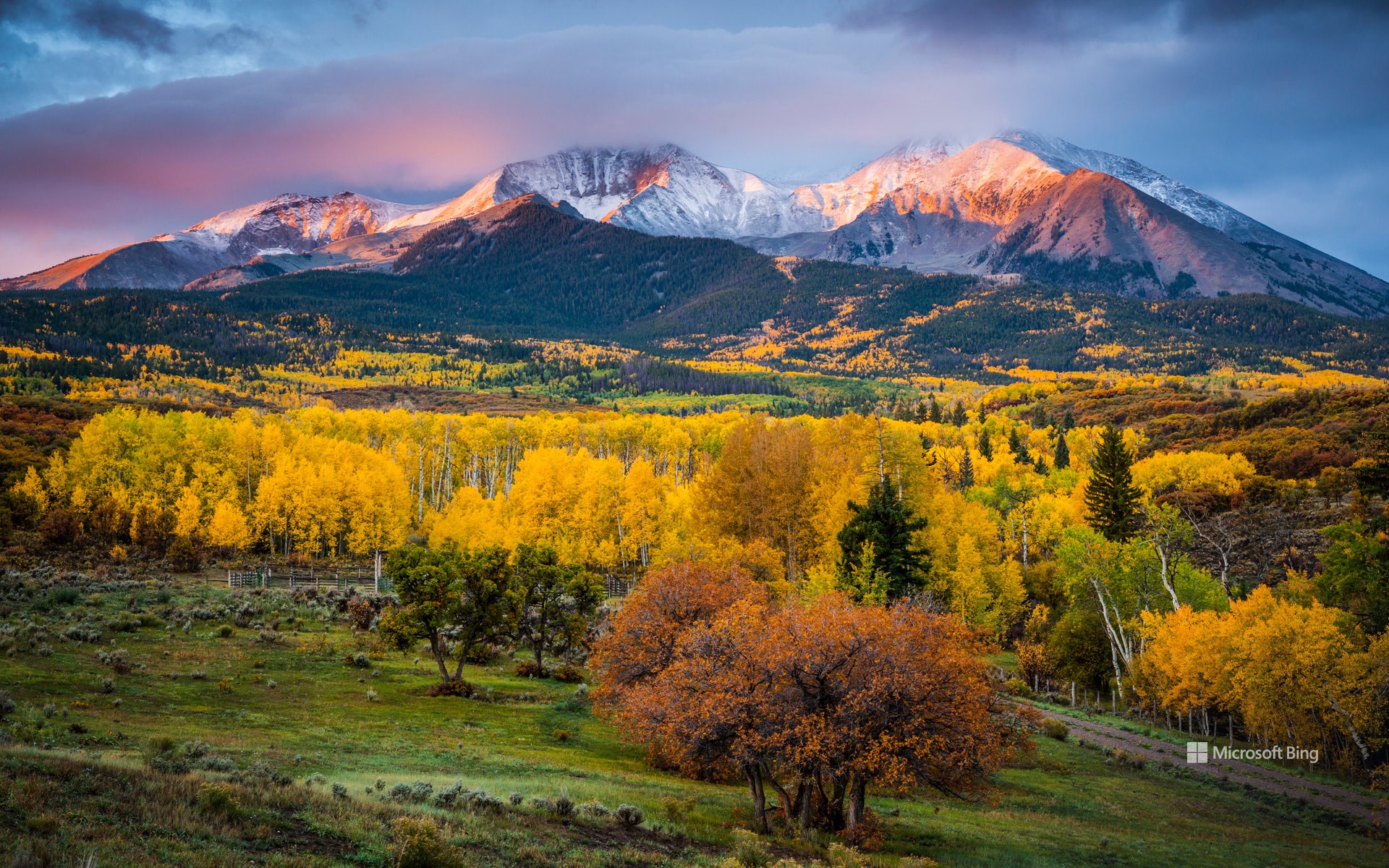
巍峨的索普里斯山矗立在科罗拉多州落基山脉中部的一支名为埃尔克的山脉上。它位于卡本代尔镇附近,拥有两个显眼的山峰,即东索普里斯山和西索普里斯山。很多人误以为索普里斯山是一座火山,但实际上,该山体内部的岩浆并没有喷发出来,而是在约10,000英尺的地下深处结晶后形成了一个巨大的被岩石覆盖的穹顶。除了自然魅力之外,索普里斯山还是多个土著民族的圣地,比如历史上曾在该地区居住过的犹他人部落就是其中之一。因此,索普里斯山一直是落基山脉的标志性景点,吸引了众多游客和探险者前来参观。
Mount Sopris, Colorado
The rising sun hits the twin peaks of Mount Sopris in this autumnal scene, in Colorado's Elk Mountains, in the Rockies. Known as East Sopris and West Sopris, the two summits are both 12,965 feet in elevation, towering over the town of Carbondale, in the Roaring Fork Valley. It's a common misconception that Mount Sopris was a volcano but, although magma built up beneath its surface, it never erupted. Instead, it crystallized about 10,000 feet beneath the Earth's surface, creating a massive rock-covered dome. Erosion by rain, melting snow and glacial ice then shaped it into this twin-peaked giant over tens of millions of years.
Mount Sopris was a hallowed site for Indigenous peoples, including the Ute tribes who have historically inhabited the region. The Roaring Fork and Crystal Valleys served as seasonal dwellings and hunting territories for the Parianuche and Yampa bands of the Ute people. The mountain continues to be a beloved emblem of the Colorado Rocky Mountains, drawing in visitors and adventurers alike.
克雷斯特德比特山上方的月食,科罗拉多州,美国 Lunar eclipse above Mount Crested Butte, Colorado (© Mengzhonghua Photography/Getty Images)
克雷斯特德比特山上方的月食,科罗拉多州,美国 Lunar eclipse above Mount Crested Butte, Colorado (© Mengzhonghua Photography/Getty Images)
宁静的夜空 Serene night sky
克雷斯特德比特山,科罗拉多州,美国
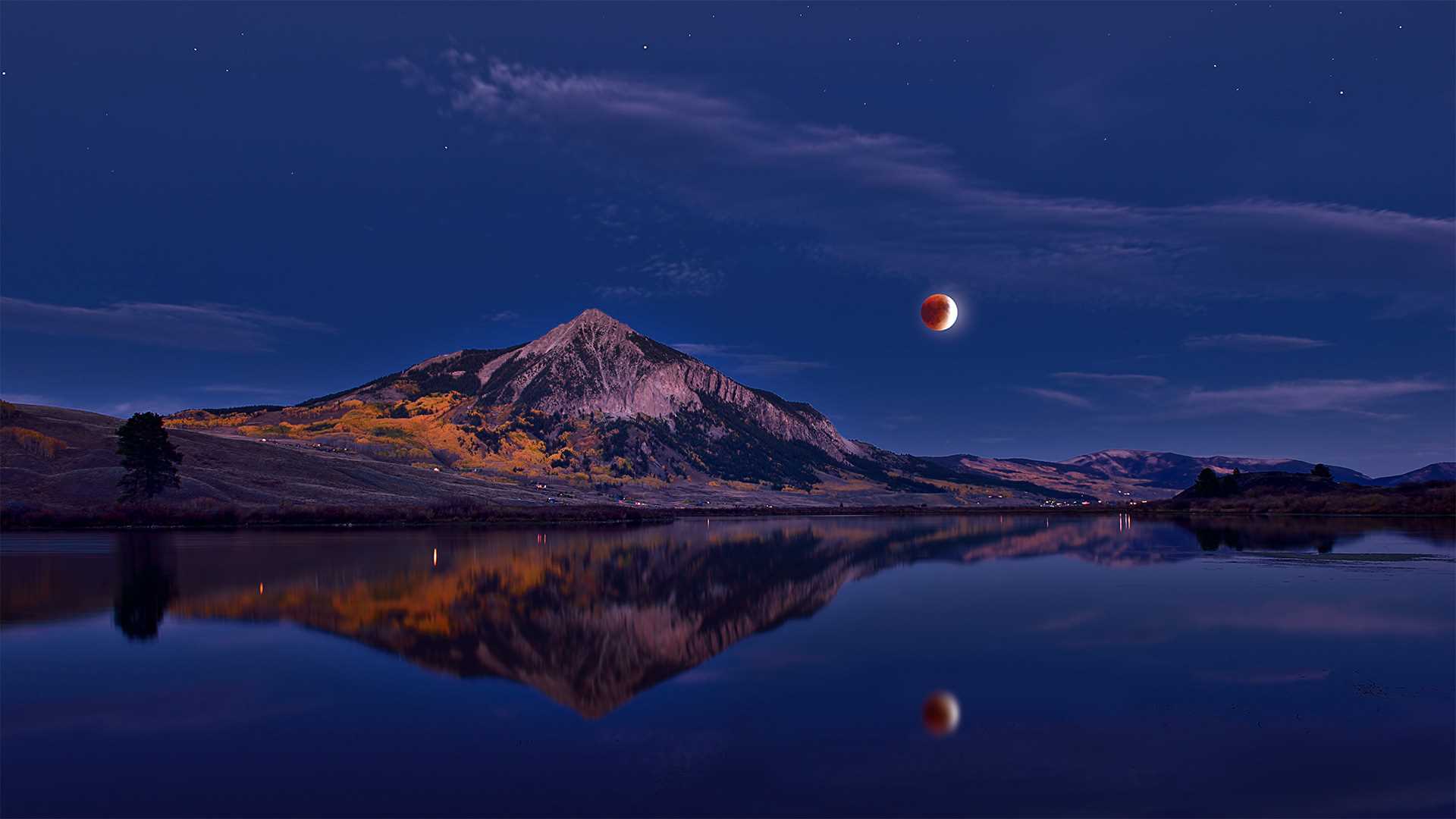
这张照片拍摄地位于克雷斯特德比特山,记录了纯净夜空中的月食现象。克雷斯特德比特山是北美落基山脉麋鹿山脉的一座著名山峰。这座12,168英尺(3,709
米)的山峰位于美国科罗拉多州甘尼森县 Crested
Butte镇附近的甘尼森国家森林。甘尼森国家森林是一座美国国家森林,占地2612.71平方英里,它与白河和圣伊莎贝尔国家森林共享Maroon
Bells-Snowmass荒野,与圣伊莎贝尔国家森林共享 Collegiate Peaks荒野地区。
最后一美元公路旁的白杨树,科罗拉多州特鲁莱德市附近 The aspen canopy along Last Dollar Road near Telluride, Colorado (© Grant Ordelheide/Tandem Stills + Motion)
最后一美元公路旁的白杨树,科罗拉多州特鲁莱德市附近 The aspen canopy along Last Dollar Road near Telluride, Colorado (© Grant Ordelheide/Tandem Stills + Motion)
属于秋天的色彩 Fall colors
Autumnal equinox
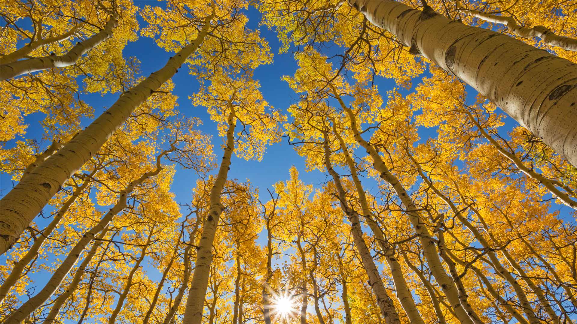
This thicket of aspen trees is on the Last Dollar Road, an 18-mile scenic drive in southwest Colorado that is as dramatic as its name suggests, with switchbacks and stunning views of peaks and meadows and of course the aspen trees that paint the land come September. Aspens thrive in the cold winters and cool summers of Colorado, where they grow at altitudes between 5,000 to 11,000 feet, typically reaching heights of 50 feet. Their distinct, round leaves quake in the wind making it appear as if the trees are glittering in the sunlight. Aspens generally grow on west-facing slopes, gorging on the afternoon sun. They're among the world's largest living organisms because aspen groves share a single root system. They're also the state's only native deciduous tree and cover about a fifth of its forested land.
秋分
这片白杨树灌木丛位于科罗拉多州西南部的Last Dollar Road,这是一条18英里长的风景线,正如它的名字所暗示的那样引人注目,在这里可以看到山峰和草地的转弯和令人叹为观止的美景,当然,到了9月份,白杨树也将为这片土地锦上添花。白杨在科罗拉多州的寒冷冬季和凉爽夏季生长旺盛,在那里它们生长在5000至11000英尺的高度,通常达到50英尺的高度。它们独特的圆形叶子在风中摇曳,使树木在阳光下显得闪闪发光。白杨通常生长在向西的斜坡上,饱食午后的阳光。它们是世界上最大的生物之一,因为白杨树林共享一个单一的根系。它们也是该州唯一的本土落叶树,约占该州林地的五分之一。
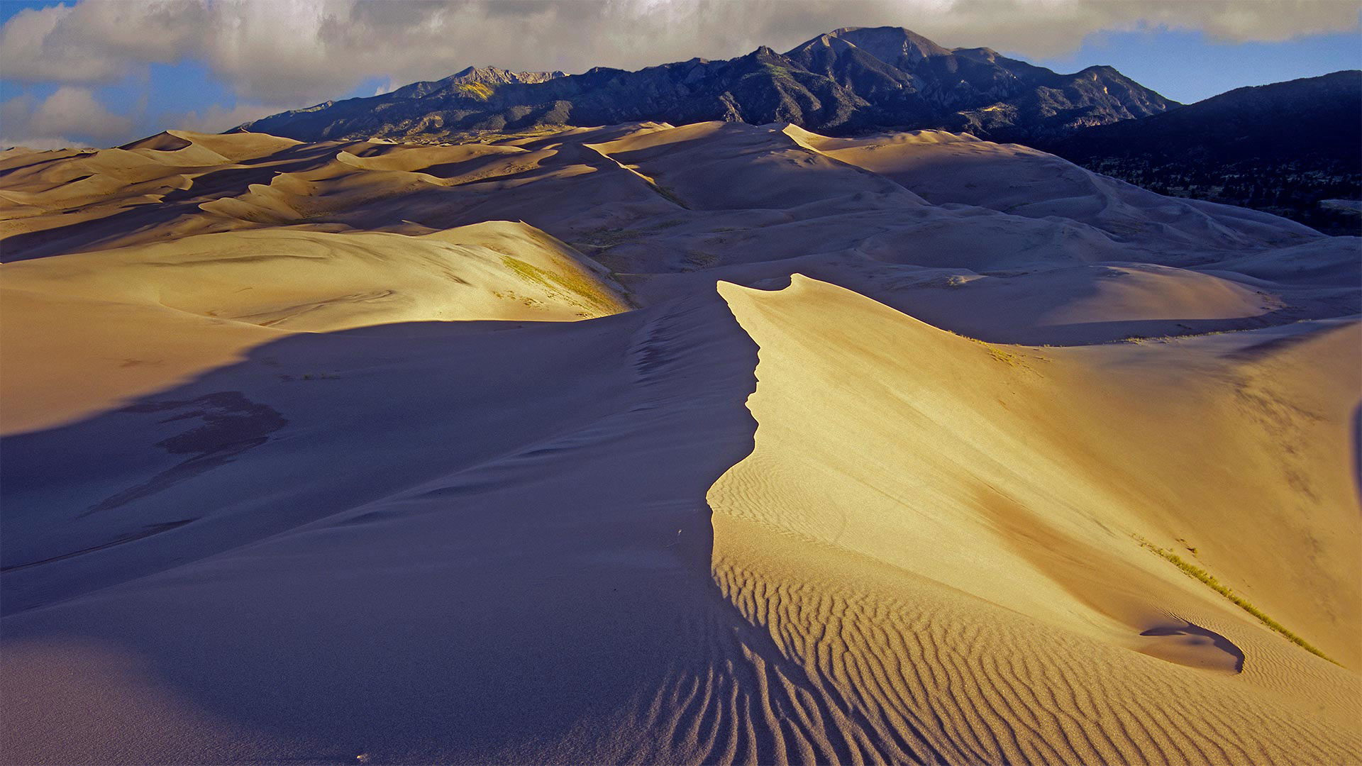
大沙丘国家公园和保护区,美国科罗拉多州 Great Sand Dunes National Park and Preserve, Colorado (© Y Paudel/Getty Images)
大沙丘国家公园和保护区,美国科罗拉多州 Great Sand Dunes National Park and Preserve, Colorado (© Y Paudel/Getty Images)
如沙漏中的沙子一般 Like sands through the hourglass
Great Sand Dunes National Park and Preserve
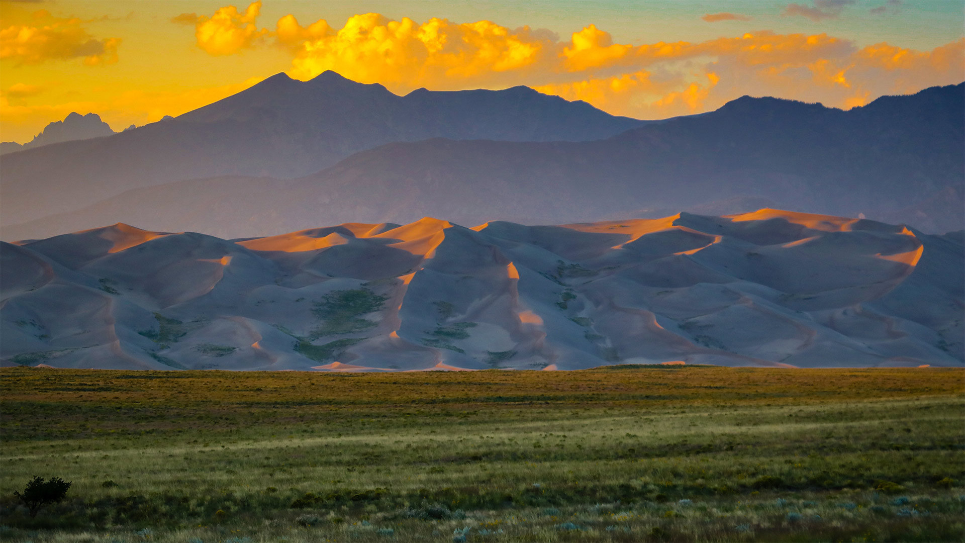
Today we celebrate the birthday of Great Sand Dunes National Park and Preserve, which boasts 750-foot (and higher) sand dunes that cover more than 30 square miles. But the towering hills of sand—the tallest in North America—are just one feature of an eye-popping Colorado landscape that includes conifer forests, alpine lakes, and wetlands. The 85,000-acre park and preserve even encompasses stretches of tundra at the higher elevations, where it edges up against the base of the Sangre de Cristo Mountains.
Initially proclaimed a national monument in 1932 by President Herbert Hoover, the territory was redesignated as Great Sand Dunes National Park and Preserve on September 13, 2004, and the size of the park was quadrupled. The park and preserve provide ample and wildly diverse activities for visitors, from sandboarding and sandsledding down the steep dunes to hiking, camping, horseback riding, and fat-tire biking.
大沙丘国家公园和保护区
今天,我们庆祝大沙丘国家公园和保护区(Great Sand Dunes National Park and Preserve)的生日,该保护区拥有750英尺(或更高)的沙丘,面积超过30平方英里。但北美最高的高耸沙山只是科罗拉多州令人瞠目的景观的一个特征,包括针叶林、高山湖泊和湿地。85000英亩的公园和保护区甚至包括高海拔地区的苔原,在那里,它与桑格雷德克里斯托山脉的底部相对。
1932年,赫伯特·胡佛总统首次宣布该地区为国家纪念碑,2004年9月13日,该地区被重新指定为大沙丘国家公园和保护区,公园面积增加了四倍。公园和保护区为游客提供了丰富多样的活动,从在陡峭的沙丘上划沙板和玩沙橇到徒步旅行、露营、骑马和骑自行车。
落基山国家公园的朗斯峰,科罗拉多州 Longs Peak in Rocky Mountain National Park, Colorado (© Andrew R. Slaton/Tandem Stills + Motion)
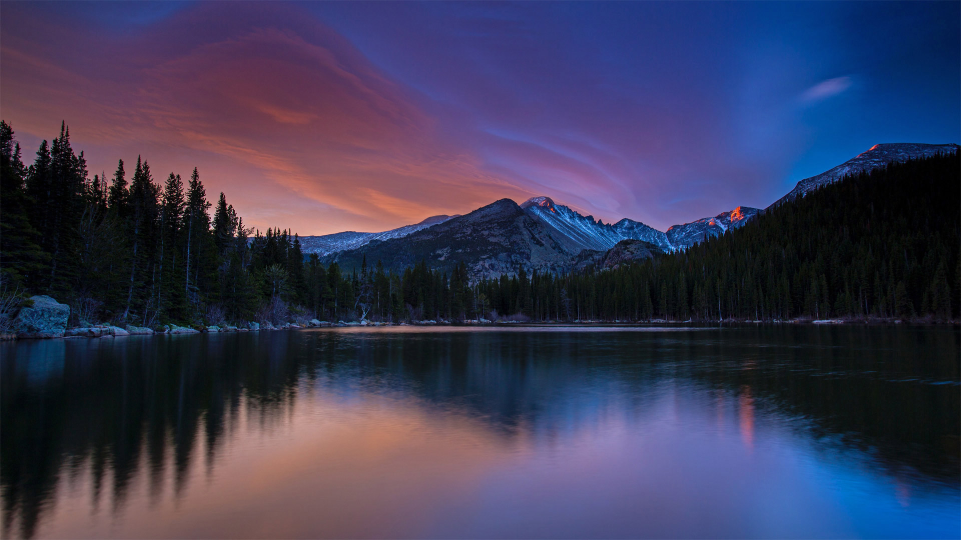
落基山国家公园的朗斯峰,科罗拉多州 Longs Peak in Rocky Mountain National Park, Colorado (© Andrew R. Slaton/Tandem Stills + Motion)
雄伟的紫色山峰 Purple mountain majesties
Longs Peak, Rocky Mountain National Park
One of the 53 'fourteeners' in Colorado—mountains that exceed 14,000 feet—Longs Peak still manages to reach higher into the heavens than any other mountain in Rocky Mountain National Park at 14,259 feet. Thousands of climbers set off every year to attempt the summit. Some climbers will try to reach the peak of every fourteener in the US during their lifetimes—that's 96 different mountains.
Once the home of the Ute and Arapaho peoples, then silver miners and mountain men, today Rocky Mountain National Park teems with outdoor enthusiasts of every stripe. Birdwatchers, bikers, and hikers give way to snowshoers, skiers, and snowboarders as the seasons change. The park if full of wildlife, including nearly seventy kinds of mammals and almost three hundred bird species
落矶山国家公园朗斯峰
科罗拉多山脉有53座“十四座”山峰,其山峰超过14000英尺长,其中一座山峰的海拔仍然比落基山脉国家公园的任何其他山峰都要高,达到14259英尺。每年都有数千名登山者出发尝试登顶。有些登山者会在一生中努力攀登美国每十四座山峰的顶峰,那是96座不同的山峰。
洛基山国家公园曾经是乌特人和阿拉帕霍人的家园,后来是银矿工人和山人的家园,今天这里挤满了各行各业的户外爱好者。随着季节的变化,观鸟者、骑自行车者和徒步旅行者会被雪鞋者、滑雪者和滑雪板者所取代。公园里到处都是野生动物,包括近70种哺乳动物和近300种鸟类
梅萨维德国家公园的方形塔楼,美国科罗拉多州 Square Tower House in Mesa Verde National Park, Colorado (© lightphoto/Getty Images)
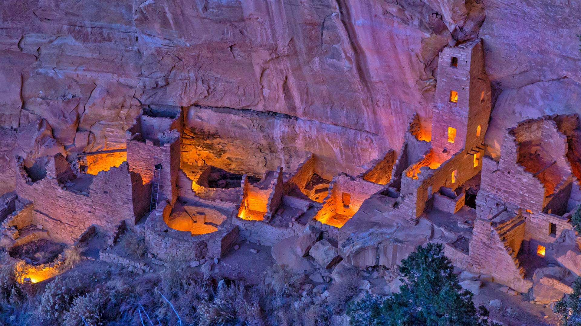
梅萨维德国家公园的方形塔楼,美国科罗拉多州 Square Tower House in Mesa Verde National Park, Colorado (© lightphoto/Getty Images)
普韦布洛城堡 Castle of the Ancestral Puebloans
Square Tower House in Mesa Verde National Park
We continue our celebration of National Park Week (through April 24)–and the UNESCO International Day for Monuments and Sites–with a visit to the impressive Square Tower House in Mesa Verde National Park. Square Tower House is one of many cliff dwellings constructed by the Ancestral Puebloans in what is now the American Southwest. At 27 feet, it's the tallest structure in the park. Square Tower House is also notable for its kiva, a round, sunken room used for ceremonies. Unlike most of the ancient kivas found in the region, the kiva at Square Tower House has an intact original clay roof supported by wooden beams.
Ancestral Puebloans lived in today's Four Corners region, where the borders of Colorado, Utah, Arizona, and New Mexico meet at a single point. It's unclear when exactly this culture emerged, but the current consensus is that the Ancestral Puebloans appeared in this area a little more than 3,000 years ago. They're believed to have built the series of cliff dwellings for defensive reasons as various factions competed for scarce resources when the region suffered from a prolonged drought. It's thought that the changing climate eventually became so severe that it likely drove them from the cliff dwellings sometime around 1300 CE, just a century or so after construction began. Today, many of the cliff dwellings have been restored and visitors can view the homes and kivas of the builders.
梅萨维德国家公园的方形塔楼
我们继续庆祝国家公园周(至4月24日)——以及联合国教科文组织纪念物和遗址国际日——参观梅萨维德国家公园令人印象深刻的方形塔楼。方塔住宅是普埃布劳恩斯家族在现在的美国西南部建造的众多悬崖住宅之一。它高27英尺,是公园里最高的建筑。方形塔楼房屋也因其kiva而著名,kiva是一个圆形的下沉式房间,用于举行仪式。与该地区发现的大多数古代基瓦不同,广场塔楼的基瓦房屋有一个完整的原始粘土屋顶,由木梁支撑。
普韦布劳恩斯的祖先生活在今天的四角地区,科罗拉多州、犹他州、亚利桑那州和新墨西哥州的边界在这里交汇。目前尚不清楚这种文化是什么时候出现的,但目前的共识是,祖先普韦布洛人在3000多年前就出现在这个地区。据信,当该地区遭受长期干旱时,各派系为了争夺稀缺资源,出于防御原因,他们修建了一系列悬崖住宅。据认为,气候变化最终变得如此严重,可能在公元1300年左右的某个时候,也就是建筑开始后的一个世纪左右,将他们赶出悬崖住宅。如今,许多悬崖上的住宅已经修复,游客可以看到建筑商的房屋和地窖。
科罗拉多河上的马蹄湾,美国亚利桑那州 Horseshoe Bend, Arizona (© Michael Dunn/Getty Images)
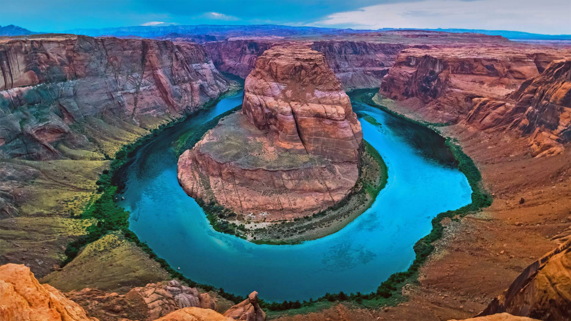
科罗拉多河上的马蹄湾,美国亚利桑那州 Horseshoe Bend, Arizona (© Michael Dunn/Getty Images)
打卡马蹄湾会带来好运吗? Does this horseshoe bring good luck?
Horseshoe Bend, Arizona
Grab your boots and gear, today we're heading to Arizona to hike out to Horseshoe Bend. Known as the 'east rim of the Grand Canyon,' it's actually about 140 miles from the other rims and is really more a part of nearby Glen Canyon. Scientifically, the beautiful view exists thanks to something called an 'entrenched meander.' Around six million years ago, the area was closer to sea level. The Colorado River, following the path of least resistance, meandered and became trapped when the Colorado Plateau uplifted around five million years ago. Over time, the river water cut through exposed sandstone, forming the thousand-foot-deep, 270-degree horseshoe-shaped bend.
Horseshoe Bend used to be a locally loved gem until social media came around to spread photos like this one. Now, nearly two million tourists a year hike to this national splendor. It's believed that, eventually, the Colorado River will cut through the neck of the bend. So, if you want your selfie with the horseshoe, you only have another million years, give or take.
亚利桑那州马蹄湾
带上你们的靴子和装备,今天我们要去亚利桑那州徒步去马蹄弯。它被称为“大峡谷的东边缘”,实际上距离其他边缘约140英里,实际上更像是附近格伦峡谷的一部分。从科学角度讲,这美丽的景色之所以存在,是因为有一种叫做“根深蒂固的曲流”的东西大约600万年前,该地区接近海平面。科罗拉多河沿着阻力最小的路径蜿蜒而行,在大约500万年前科罗拉多高原抬升时陷入困境。随着时间的推移,河水穿过裸露的砂岩,形成了千英尺深、270度马蹄形的弯曲。
马蹄弯曾经是当地人喜爱的珍宝,直到社交媒体开始传播像这样的照片。现在,每年有近200万游客徒步前往这个国家的辉煌。据信,科罗拉多河最终将穿过弯道的颈部。所以,如果你想在马蹄铁上自拍,你只能再活一百万年,不管付出与否。
达拉斯分水岭, 科罗拉多州西南部 Dallas Divide in southwest Colorado (© Ronda Kimbrow/Shutterstock)
达拉斯分水岭, 科罗拉多州西南部 Dallas Divide in southwest Colorado (© Ronda Kimbrow/Shutterstock)
A valley view at 9,000 feet
This is the Dallas Divide, but we're hundreds of miles from (and 8,500 feet above) North Texas. This saddle amid the southwestern Colorado Rockies cuts a swath just north of the San Juan Mountains. Nestled in those peaks you'll find Telluride, Silverton, and other former mining towns that got a boost from the Rio Grande Southern Railroad when it came to the Dallas Divide in 1890. Nowadays the divide hosts US Highway 62, a less-traveled byway for most Colorado travelers—but worth the detour if you're keen on a sweeping valley vista.
海拔9000英尺的山谷景色
这是达拉斯分水岭,但我们离北德克萨斯州数百英里(海拔8500英尺)。这座位于科罗拉多州落基山脉西南部的马鞍山在圣胡安山脉以北划出一条狭长的地带。坐落在这些山峰上,你会发现泰勒里德、西尔弗顿和其他以前的矿业城镇,这些城镇在1890年到达达拉斯分水岭时受到了格兰德南部铁路的推动。如今,这条分水岭拥有美国62号公路,对于大多数科罗拉多州的旅行者来说,这是一条人迹罕至的小道,但如果你想看到一片广阔的山谷景色,那么绕道而行是值得的。
以桑格雷-德克里斯托山为背景的沙丘,科罗拉多州大沙丘国家公园 Sand dunes with Sangre de Cristo Mountains in the background, Great Sand Dunes National Park and Preserve, Colorado (© Tim Fitzharris/Minden Pictures)
以桑格雷-德克里斯托山为背景的沙丘,科罗拉多州大沙丘国家公园 Sand dunes with Sangre de Cristo Mountains in the background, Great Sand Dunes National Park and Preserve, Colorado (© Tim Fitzharris/Minden Pictures)
Super Sandy Sweet 16
We're in the Rockies of southern Colorado to celebrate Great Sand Dunes National Park and Preserve's 16th year as a full-fledged national park—though it was a national monument from 1932, and both the dunes themselves and the surrounding valley's history are far more ancient.
The dunes lie at the edge of the fertile, expansive San Luis Valley just east of the Rio Grande's headwaters and west of the Sangre de Cristo range shown here behind the dunes. Humans have lived around here for at least 11,000 years. But that's just a few grains in the hourglass for this sand field that formed when huge glacial lakes dried up, leaving sediments that were blown by wind against the mountains to slowly form the tallest sand dunes in North America.
位于科罗拉多南部圣胡安山脉的美国盆地 American Basin in southern Colorado's San Juan Mountains (© Blaine Harrington III/Alamy)
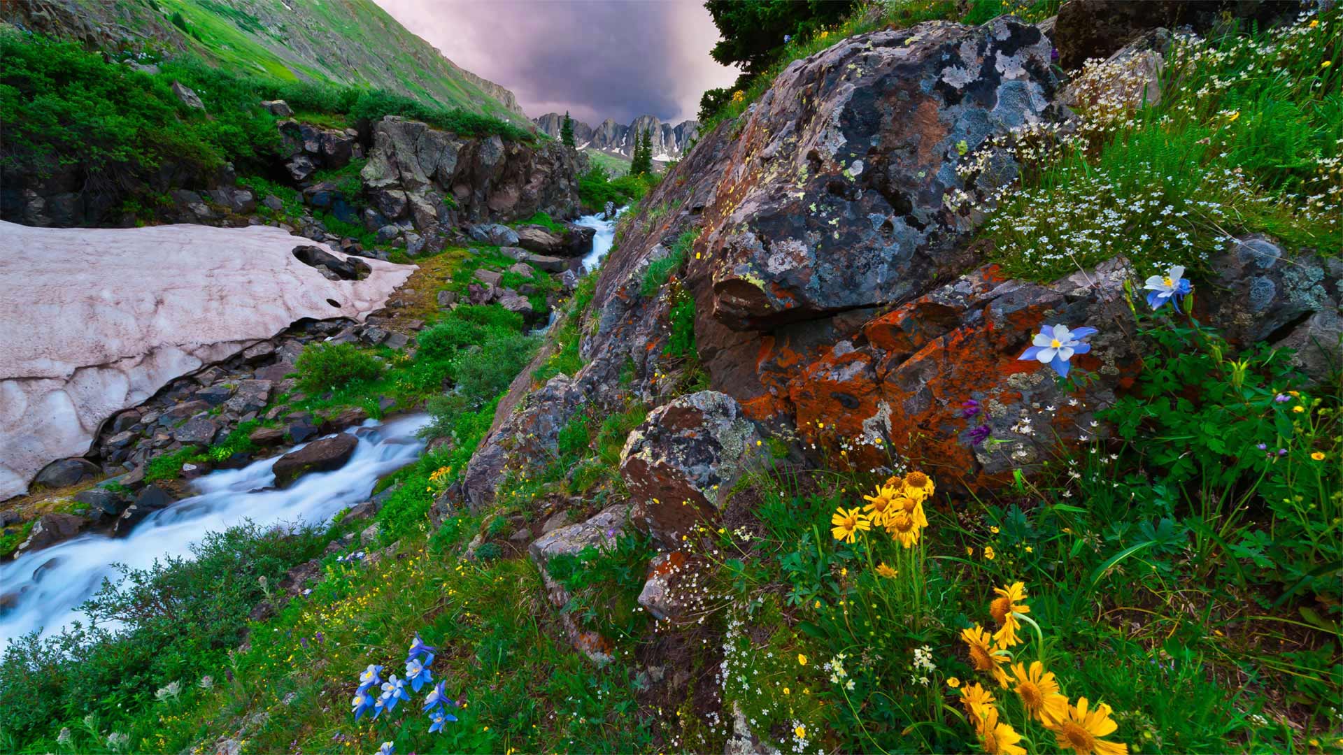
位于科罗拉多南部圣胡安山脉的美国盆地 American Basin in southern Colorado's San Juan Mountains (© Blaine Harrington III/Alamy)
High alpine color in Colorado
Songstress Dolly Parton once sang 'wildflowers don't care where they grow,' but we gotta believe the wildflowers growing in Colorado's American Basin, shown here, are pretty delighted with their surroundings. American Basin is in the San Juan Mountains in the southern part of the state, about a 5-hour drive from Denver. Visitors here will find rocky cliffs, streams, unique rock formations, and some spectacular wildflowers. July and August are the best time to see the blooms—it's the time of year when you'll reliably spot the Rocky Mountain columbine (Colorado's state flower), elephant's head, Parry's primrose, and marsh marigold. Bring us back a bouquet, all right?