标签 瀑布 下的文章
日落时分的阿萨巴斯卡瀑布,加拿大 Sunset lights up Mount Fryatt as the Athabasca River flows over Athabasca Falls in Jasper National Park, Alberta, Canada (© Robert Postma/Getty Images)
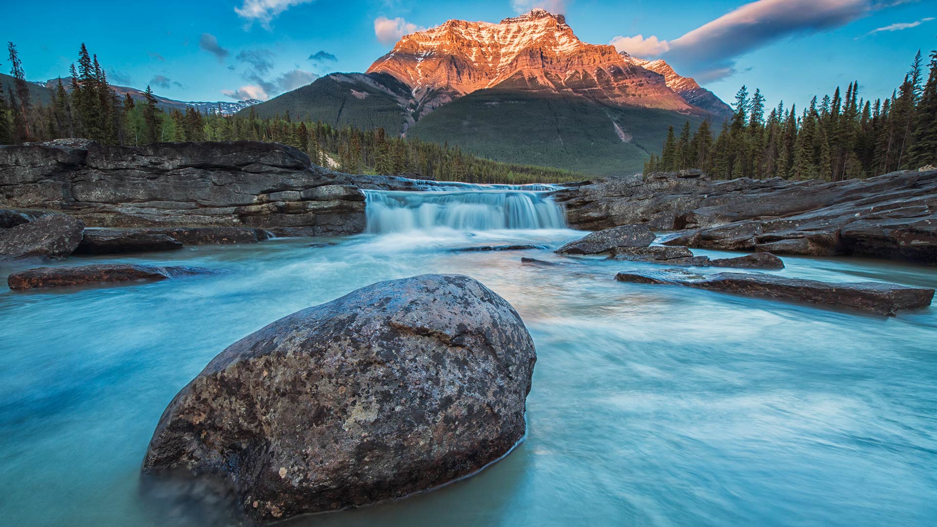
日落时分的阿萨巴斯卡瀑布,加拿大 Sunset lights up Mount Fryatt as the Athabasca River flows over Athabasca Falls in Jasper National Park, Alberta, Canada (© Robert Postma/Getty Images)
奔腾不息的自然力量 Small but mighty
Athabasca Falls in Jasper National Park
Athabasca Falls is one of the most striking waterfalls on the Icefields Parkway, and a visit to Jasper National Park in Alberta wouldn't be complete without it. Despite its low height of just 23 meters, the incredible volume and intensity of the falls make it a renowned gem of the Canadian Rockies. The falls are fed with pristine water flowing from the Columbia Icefield glaciers and snowmelt from neighboring mountains. Mount Fryatt makes for the perfect backdrop with its horn-shaped summit; a result of being carved and sculpted by glaciers from all angles over the years. Mount Fryatt consists of sedimentary rocks deposited from the Precambrian to Jurassic eras.
贾斯珀国家公园阿萨巴斯卡瀑布
阿萨巴斯卡瀑布是冰原公园路上最引人注目的瀑布之一,没有它,参观亚伯达省的贾斯珀国家公园就不算完整。尽管它的低高度只有23米,但令人难以置信的瀑布体积和强度使它成为加拿大落基山脉著名的宝石。这些瀑布由哥伦比亚冰原冰川流出的纯净水和邻近山脉的融雪补给。弗赖亚特山以其喇叭形的山顶成为完美的背景;这是多年来冰川从各个角度雕刻的结果。Fryatt山由前寒武纪至侏罗纪沉积岩组成。
阿尔比恩瀑布,汉密尔顿,加拿大安大略省 Albion Falls, Hamilton, Ontario, Canada (© Alexander Sviridov/Shutterstock)
阿尔比恩瀑布,汉密尔顿,加拿大安大略省 Albion Falls, Hamilton, Ontario, Canada (© Alexander Sviridov/Shutterstock)
“瀑布之城”中的小瀑布 Cascade in the 'City of Waterfalls'
Albion Falls, Hamilton, Ontario, Canada
The spectacular Albion Falls is just one of more than 130 waterfalls that give the city of Hamilton in Ontario, Canada, its sobriquet: Waterfall Capital of the World. The city eagerly welcomes visitors to share in its natural beauty, and there are hiking and biking trails around the waterfalls as well as guided tours. On the edge of Lake Ontario, Hamilton lies 54 miles northwest of Niagara.
As you can see here, Albion Falls is a stepped waterfall with cascading flows that fan out spectacularly. It's 62 feet high (and almost as wide), and there are two viewing platforms at the top for jaw-dropping photo ops. Just obey the signs and watch your footing: There is some fencing, but the ground can be unstable near the cliff edges.
加拿大安大略省汉密尔顿阿尔比恩瀑布
壮观的阿尔比恩瀑布只是加拿大安大略省汉密尔顿市130多个瀑布中的一个,它的绰号是:世界瀑布之都。该市热切欢迎游客分享其自然美景,瀑布周围有徒步旅行和骑自行车的小径,还有导游。汉密尔顿位于安大略湖边缘,尼亚加拉西北54英里处。
正如你在这里看到的,阿尔比恩瀑布是一个阶梯式瀑布,层叠的水流以惊人的扇形散开。它高62英尺(几乎和它一样宽),顶部有两个观景台,用于拍摄令人瞠目结舌的照片。只要遵守指示牌并注意脚下:有一些围栏,但悬崖边缘附近的地面可能不稳定。
春天的豹溪瀑布,吉福德·平肖国家森林,美国华盛顿州 Panther Creek Falls in spring, Gifford Pinchot National Forest, Washington (© Stephen Matera/Tandem Stills + Motion)
春天的豹溪瀑布,吉福德·平肖国家森林,美国华盛顿州 Panther Creek Falls in spring, Gifford Pinchot National Forest, Washington (© Stephen Matera/Tandem Stills + Motion)
拥有6000年历史的大森林 A large forest with 6,000 of years of history
Gifford Pinchot National Forest
Today we're paying a visit to an 'elder statesman' of the United States' national forests. Seen in today's photo is Panther Creek Falls at Gifford Pinchot National Forest in Washington state. Officially, the forest was named in 1949 in honor of Pinchot, the first head of the US Forest Service. Located between Mount St. Helens to the west and Mount Adams to the east, the land was set aside as a place worth preserving as far back as 1897. But people had been living in the forest for more than 6,000 years. Archaeologists continue to make discoveries within the dense forest that teach us about the past lives of Native Americans.
Spanning 1.3 million acres, GPNF exhibits an array of natural wonders: forests, wildlife, mountains, and numerous rivers and lakes that offer excellent fishing. Goose Lake is said to be the best fishing hole in the state. The forest is known as a native habitat for several threatened species, like the spotted owl, bull trout, and chinook salmon. One of the largest known Ponderosa pines in the world rose 202 feet at the base of Mount Adams before its death in 2015. The grounds also include the 110,000-acre Mount St. Helens National Volcanic Monument, established in 1982.
吉福德平肖国家森林
今天我们要拜访美国国家森林的一位“资深政治家”。在今天的照片中可以看到华盛顿州吉福德平肖国家森林的豹溪瀑布。该森林于1949年正式命名,以纪念美国林业局第一任局长平肖。这片土地位于西面的圣海伦斯山和东面的亚当斯山之间,早在1897年就被作为一个值得保护的地方保留下来。但是人们已经在森林里生活了6000多年。考古学家继续在茂密的森林中进行发现,让我们了解美洲原住民的过去生活。
GPNF占地130万英亩,展示了一系列自然奇观:森林、野生动物、山脉,以及无数河流和湖泊,这些河流和湖泊提供了极好的渔业。鹅湖据说是该州最好的渔场。这片森林被称为几种濒危物种的原生栖息地,如斑点猫头鹰、牛鳟鱼和奇努克鲑鱼。2015年亚当斯山死亡前,世界上已知最大的黄松之一在亚当斯山的底部上升了202英尺。场地还包括建于1982年的占地11万英亩的圣海伦斯山国家火山纪念碑。
北极光下的众神瀑布,冰岛 Goðafoss waterfall under the northern lights, Iceland (© Anton Petrus/Getty Images)
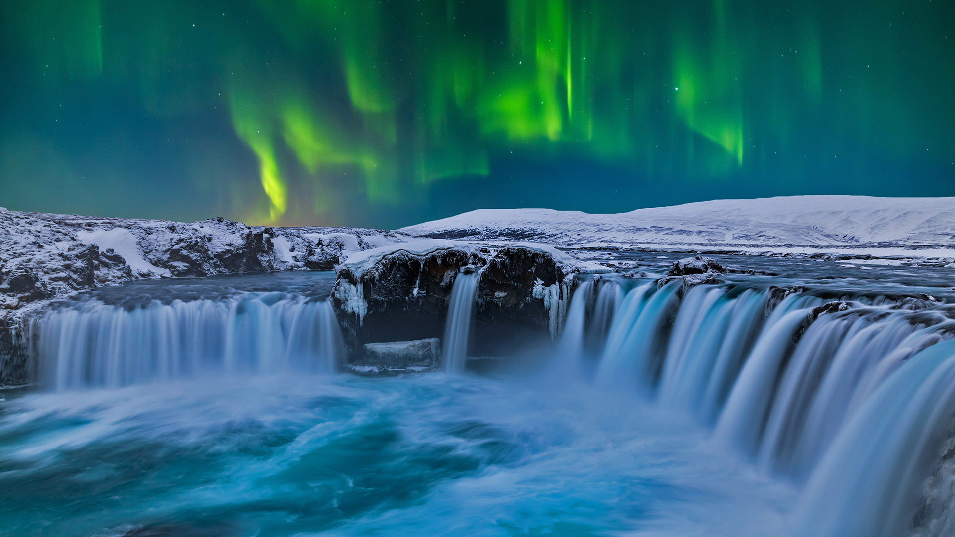
北极光下的众神瀑布,冰岛 Goðafoss waterfall under the northern lights, Iceland (© Anton Petrus/Getty Images)
Goðafoss waterfall, Iceland
Goðafoss is one of the hundreds of show-stopping waterfalls Iceland is blessed with. And though it isn't the island's highest waterfall—that would be Morsarfoss at over 240 meters—or most powerful (the thundering Dettifoss), Goðafoss, has, within its swirling waters, its own story to tell.
An Icelandic legend holds that in 1000 CE, a well-respected pagan priest and chieftain named Thorgeir Thorkelsson was tasked with deciding if Iceland was to become a Christian nation or if it would continue to worship the ancient Nordic gods. The peace of the island was at stake, with fierce advocates on each side. Thorgeir decided in favor of Christianity, but with the caveat that those who chose to continue to recognize the old gods would not be punished so long as they converted. This tale, likely created in the nineteenth century, says that after Thorgeir converted to Christianity he returned to his home near Goðafoss and hurled his statues of the Norse gods into the falls, which is said to have angered the old gods so much that they split the waterfall in two. Which might be enough to make one rethink angering them in the first place.
Goðafoss瀑布,冰岛
Goðafoss是冰岛拥有的数百座停止表演的瀑布之一。尽管它不是岛上最高的瀑布,也不是海拔240米以上的穆萨福斯瀑布,也不是最强大的瀑布(雷鸣般的Dettifoss),但Goðafoss在其漩涡中有自己的故事要讲。
冰岛的一个传说认为,公元1000年,一位受人尊敬的异教徒牧师和酋长托尔盖尔·托克尔松(Thorgeir Thorkelsson)受命决定冰岛是要成为一个基督教国家,还是要继续崇拜古代北欧诸神。岛上的和平岌岌可危,双方都有强烈的支持者。索盖尔决定支持基督教,但有一条警告:那些选择继续承认旧神的人,只要他们皈依,就不会受到惩罚。这个故事可能是在19世纪创作的,故事中说,托尔盖尔皈依基督教后回到他在戈阿福斯附近的家中,将他的北欧诸神雕像扔进瀑布,据说这激怒了古神,以至于他们将瀑布一分为二。这可能足以让人重新思考一开始会激怒他们。
旺阿雷自然保护区里的旺阿雷瀑布,新西兰北岛 Whangarei Falls located in Whangarei Scenic Reserve on North Island, New Zealand (© Nathan Kavumbura/Getty Images)
旺阿雷自然保护区里的旺阿雷瀑布,新西兰北岛 Whangarei Falls located in Whangarei Scenic Reserve on North Island, New Zealand (© Nathan Kavumbura/Getty Images)
野餐的好去处 Pretty as a picnic
Whangarei Falls in New Zealand's North Island
This lush, Eden-esque location on New Zealand's North Island has been a popular spot to bring a blanket and basket and lay out lunch since at least the 1890s. Whangārei Falls is part of the Hātea River. At the falls, seen in our photo, the river drops 85 feet over a basalt lava flow. The surrounding park provides a loop trail ideal for a hike along the edge of the river.
English horology enthusiast Archibald Clapham purchased the land here, including the falls, during the 1920s to save the landscape from commercial exploitation. The North Island preserve was later purchased by the Whangārei Businessmen's Association, which turned the space into a public park. Thanks to their preservation work, this island paradise provides respite for visitors from nearby towns and around the globe.
新西兰北岛的旺加雷瀑布
至少从19世纪90年代起,这座位于新西兰北岛、郁郁葱葱的伊甸园式建筑就一直是人们带毯子、篮子和摆设午餐的好去处。黄ā赖瀑布是Hātea河的一部分。在瀑布,我们的照片中看到,河流在玄武岩熔岩流上下降了85英尺。周围的公园提供了一条环形小径,非常适合沿着河边徒步旅行。
英国钟表爱好者阿奇博尔德·克拉帕姆(Archibald Clapham)在20世纪20年代购买了这里的土地,包括瀑布,以避免商业开发。北岛保护区后来被黄ā赖商人协会收购,该协会将该保护区变成了一个公共公园。多亏了他们的保护工作,这个岛屿天堂为来自附近城镇和全球各地的游客提供了休憩之所。
千泉州立公园的瀑布,美国爱达荷州 Waterfall in Thousand Springs State Park, Hagerman Valley, Idaho (© knowlesgallery/Getty Images)
千泉州立公园的瀑布,美国爱达荷州 Waterfall in Thousand Springs State Park, Hagerman Valley, Idaho (© knowlesgallery/Getty Images)
什么是地球上最珍贵的资源? Earth's most precious resource?
World Water Day
You can almost hear the crash and feel the spray of this pristine cluster of waterfalls in southern Idaho. Could there be a better place to celebrate World Water Day? Since 1993, the UN has dedicated March 22 to advocate for sustainable management of freshwater resources and bring attention to topics relevant to clean water, sanitation, and hygiene. Each year has emphasized a different aspect of this critical resource, with themes like 'Valuing Water,' 'Water and Climate Change,' 'Water and Jobs,' and 'Why Waste Water?' This year's theme is 'Groundwater—Making the Invisible Visible.'
Groundwater surfaces in spectacular fashion here at Thousand Springs State Park, located in a beautiful corner of Idaho—the aptly named Magic Valley. The springs here are fed by the Eastern Snake Plain Aquifer, one of the largest aquifers in the United States, about the size of Lake Erie. The groundwater in the aquifer travels from its source just 1 to 10 feet per day and can take 150 to 250 years to flow into Thousand Springs and the Snake River.
世界水日
你几乎可以听到撞击声,感受到爱达荷州南部这片原始瀑布群的喷射声。有更好的地方庆祝世界水日吗?自1993年以来,联合国一直致力于3月22日倡导淡水资源的可持续管理,并提请人们注意与清洁水、卫生和个人卫生相关的话题。每年都会强调这一关键资源的不同方面,主题包括“重视水”、“水与气候变化”、“水与就业”以及“为什么要浪费水?”今年的主题是“地下水让看不见的东西看得见”
千泉州立公园位于爱达荷州一个美丽的角落,名字恰如其分的魔法谷,这里的地下水以壮观的方式浮出水面。这里的泉水来自东部蛇平原含水层,这是美国最大的含水层之一,大约有伊利湖那么大。含水层中的地下水每天从源头流出仅1至10英尺,需要150至250年才能流入千泉和蛇河。
Linn of Quoich瀑布旁的碗状岩石洞,苏格兰阿伯丁郡 (© AWL Images/Danita Delimont)
梅加拉亚邦的七姐妹瀑布,印度 Nohsngithiang Falls in Meghalaya, India (© Upamanyoo Das/Shutterstock)
梅加拉亚邦的七姐妹瀑布,印度 Nohsngithiang Falls in Meghalaya, India (© Upamanyoo Das/Shutterstock)
India Nohsngithiang Falls
Nohsngithiang Falls is a picturesque waterfall located south of Mawsmai village in East Khasi Hills district in Meghalaya, India. The waterfalls from a height of 315 metres (1,033 ft), segmented into seven different sections, giving it the epithet of the Seven Sisters Waterfalls. As the name suggests, it has seven different waterfalls that are strategically arranged side by side on a high, rugged cliff, and they look compelling even from a distance. The scintillating waterfall is seasonal and plunges over the limestone-covered hills only during the monsoon.
Nohsngithiang Falls is symbolic of the seven sister states of Northeast India namely Assam, Arunachal Pradesh, Manipur, Nagaland, Tripura, Mizoram, and Meghalaya. The waterfall cannot be entered into but creates a spectacular viewpoint that can be seen from nearby bridges and sheds. The beauty of the waterfall is indescribable during sunset when the rays of the sun fall on it creating a perennial rainbow, which is also one of the major highlights of the place.
印度诺兴钦瀑布
Nohsngitiang瀑布是一个风景如画的瀑布,位于印度Meghalaya东Khasi Hills区Mawsmai村南部。瀑布的高度为315米(1033英尺),分为七个不同的部分,被称为七姐妹瀑布。顾名思义,它有七个不同的瀑布,从战略上讲,它们并排排列在一个高而崎岖的悬崖上,即使从远处看,它们也是引人注目的。闪烁的瀑布是季节性的,只有在季风季节才会在石灰岩覆盖的山丘上俯冲。
Nohsngithiang Falls象征着印度东北部的七姐妹州,即阿萨姆、阿鲁纳恰尔邦、曼尼普尔、Nagaland、特里普拉、米佐拉姆邦和梅加拉亚邦。瀑布无法进入,但创造了一个壮观的观点,可以从附近的桥梁和棚屋看到。日落时,阳光照射在瀑布上,形成了一道经久不衰的彩虹,这也是这个地方的主要亮点之一,瀑布的美丽是无法形容的。
Khuean Srinagarindra国家公园的Huay Mae Khamin瀑布, 泰国 Huay Mae Khamin waterfall in Khuean Srinagarindra National Park, Thailand (© Casper1774Studio/Getty Images)
Khuean Srinagarindra国家公园的Huay Mae Khamin瀑布,泰国 Huay Mae Khamin waterfall in Khuean Srinagarindra National Park, Thailand (© Casper1774Studio/Getty Images)
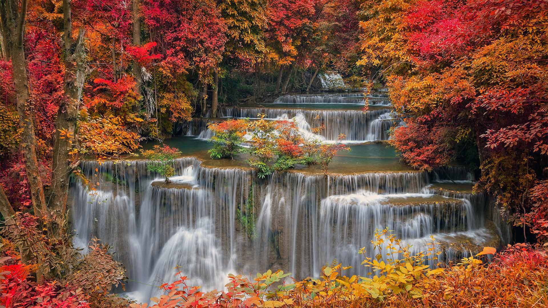
Great on so many levels
Water flows evenly over seven distinct tiers of packed earth at Huay Mae Khamin waterfall, a remote gem 4 hours' drive northwest of Bangkok. Part of Khuean Srinagarindra National Park, the falls feature a trail network leading up to each terrace, offering visitors a close-up look at every level of the picturesque cascade.
在很多层面上都很棒
在华美哈明瀑布,水流均匀地流过七层不同的堆积土。华美哈明瀑布位于曼谷西北部,距离遥远,只有4小时车程。瀑布是Khuean Srinagarindra国家公园的一部分,有一条通往每个露台的小径网络,游客可以近距离观察风景如画的瀑布的每一层。
冰岛北部内陆景观中的Aldeyjarfoss瀑布 Aldeyjarfoss waterfall in northern Iceland's interior landscape (© Jim Patterson/Tandem Stills + Motion)
冰岛北部内陆景观中的Aldeyjarfoss瀑布 Aldeyjarfoss waterfall in northern Iceland's interior landscape (© Jim Patterson/Tandem Stills + Motion)
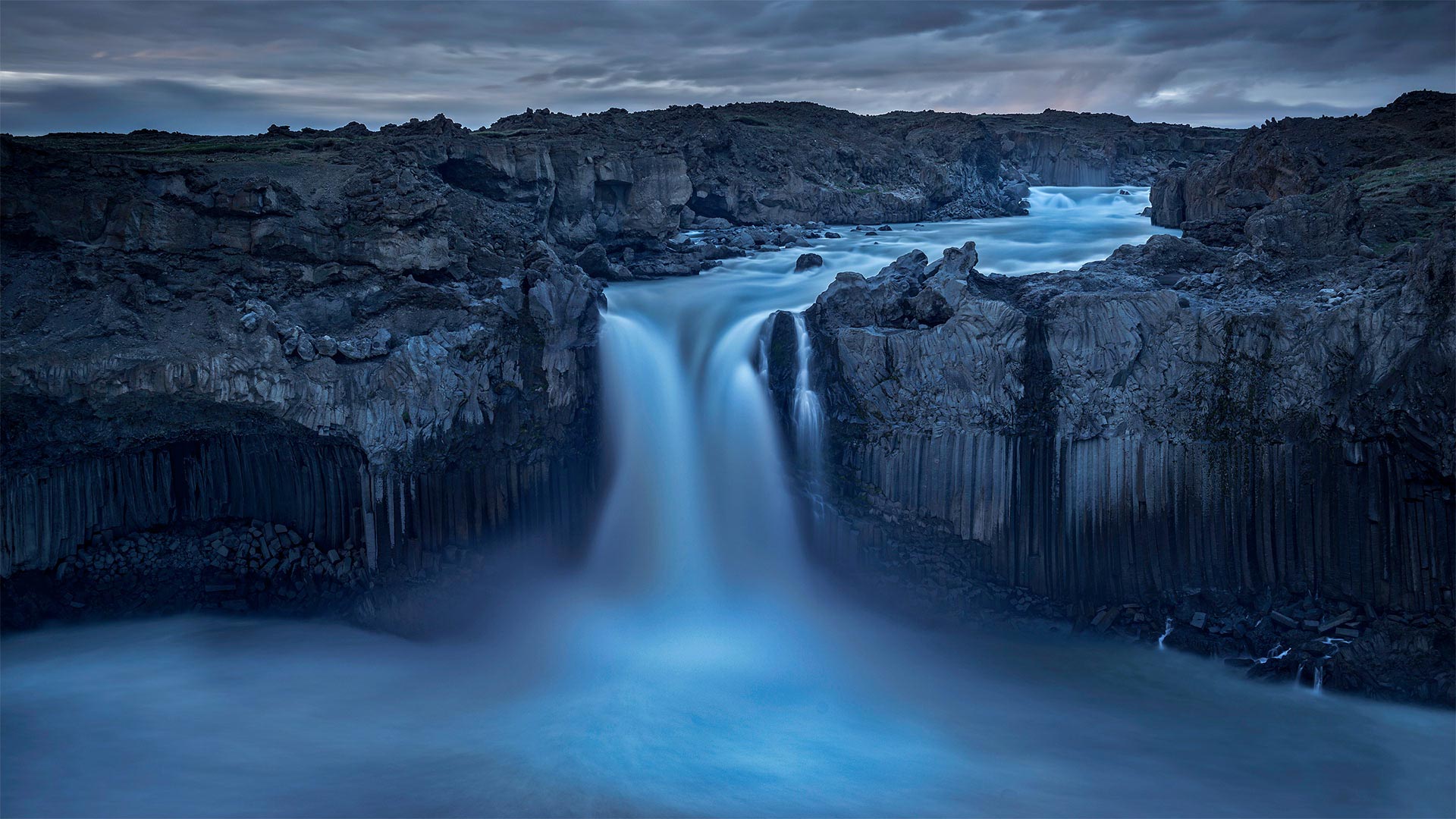
Behold the mighty Aldeyjarfoss
In waterfall-dense Iceland, it says something that Aldeyjarfoss is considered one of the most beautiful sights in the country. Fed by Iceland's largest ice cap, the 65-foot falls are flanked by distinctive hexagon-shaped basalt columns seemingly carved by some Norse god.
Okay, they may not have their origins with Odin's kin. Geologists will tell us that they're formed as lava flows cool and buckle under stress, with cracks penetrating deep into newly formed rock. The path of least resistance places these cracks at 120-degree intersections. So as cracks run deeper, their shape averages out to a near-perfect hexagon—exposing neatly geometric columns when the rock face eventually shears off.
看看强大的阿尔迪亚福斯
在瀑布密布的冰岛,阿尔迪亚尔福斯被认为是该国最美丽的景点之一。由冰岛最大的冰盖支撑,65英尺高的瀑布两侧是独特的六边形玄武岩柱,似乎是由一些挪威神雕刻而成。
好吧,他们可能不是奥丁的亲戚。地质学家会告诉我们,它们是在熔岩流冷却并在应力作用下弯曲时形成的,裂缝深入新形成的岩石。阻力最小的路径将这些裂缝放置在120度交叉处。因此,当裂缝越深,当岩石表面最终剪切时,它们的形状平均为接近完美的六边形,露出整齐的几何柱。