2022年11月
威拉米特国家森林麦肯齐河步道上的桥,美国 Bridge on the McKenzie River Trail, Willamette National Forest, Oregon (© Don Paulson/Danita Delimont)
威拉米特国家森林麦肯齐河步道上的桥,美国 Bridge on the McKenzie River Trail, Willamette National Forest, Oregon (© Don Paulson/Danita Delimont)
徒步旅行 Take a hike!
麦肯齐河步道上的桥梁
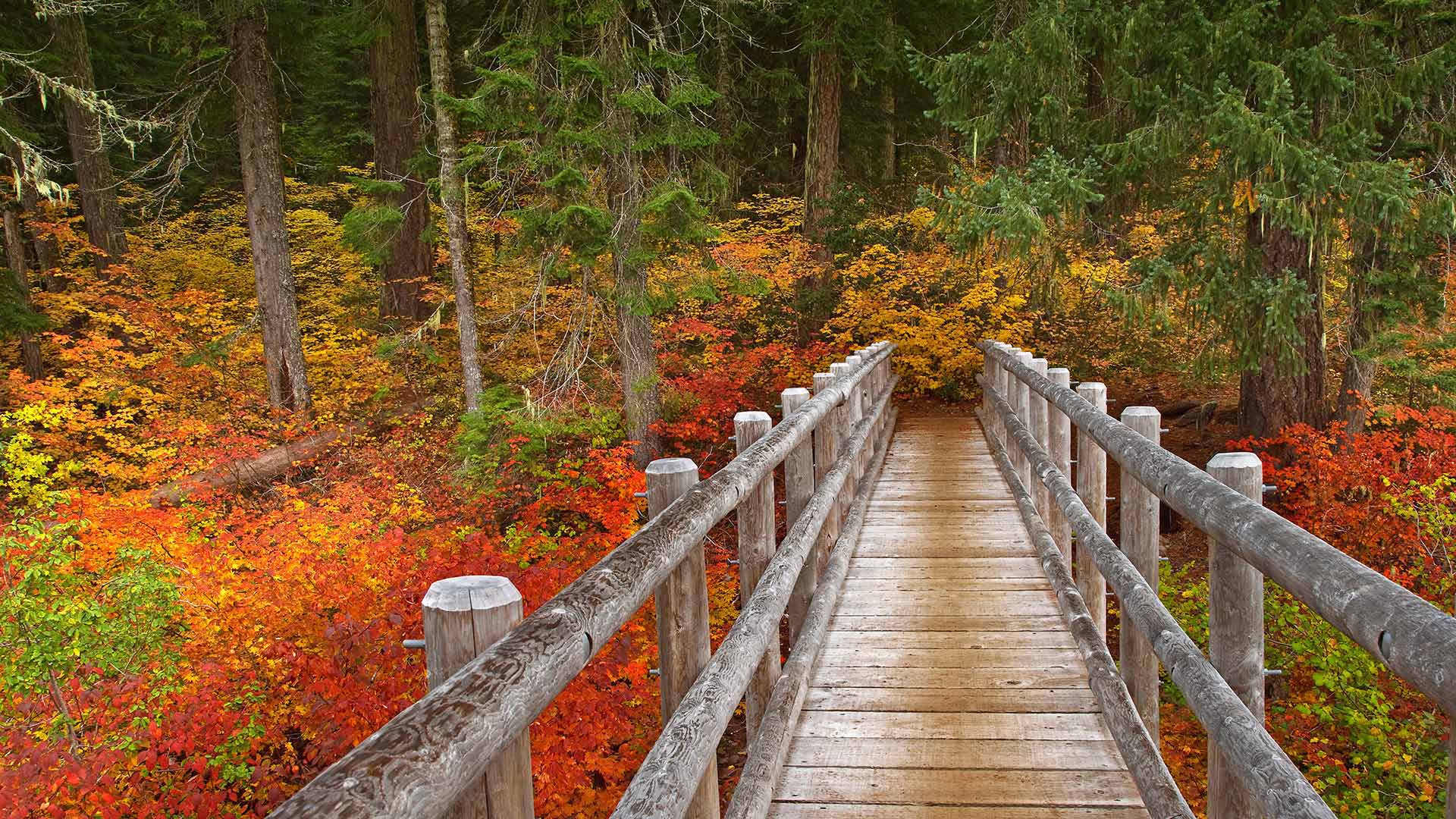
我们的照片显示俄勒冈州的麦肯齐河国家休闲步道,威拉米特国家森林的一部分。这条小径蜿蜒于湖泊、河流和泉水之间,引导您穿过荫蔽的古老森林。其中一个亮点是可以俯瞰塔莫利奇蓝池(Tamolich Blue Pool),这是一个清澈见底的游泳池,由河水注入其中而成。
Bridge on the McKenzie River Trail
Our photo shows Oregon's McKenzie River National Recreation Trail, part of the Willamette National Forest. This trail winds by lakes, rivers, and springs, guiding you through shady old-growth forests. One highlight: the view overlooking Tamolich Blue Pool, a crystal-clear pool created by the river bubbling up into it.
梅萨维德国家公园的悬崖宫,美国 Cliff dwellings in Mesa Verde National Park in Colorado, USA (© Brad McGinley Photography/Getty Images)
梅萨维德国家公园的悬崖宫,美国 Cliff dwellings in Mesa Verde National Park in Colorado, USA (© Brad McGinley Photography/Getty Images)
《保护世界文化和自然遗产公约》 A 50-year balancing act
世界遗产50年
在1972年11月16日的《世界遗产公约》上,联合国教科文组织通过了一项国际条约,首次将自然保护和文化遗产保护的概念联系起来。世界遗产项目是由埃及计划修建的阿斯旺大坝引发的,该大坝将淹没尼罗河流域的大片地区和数千件考古珍品。
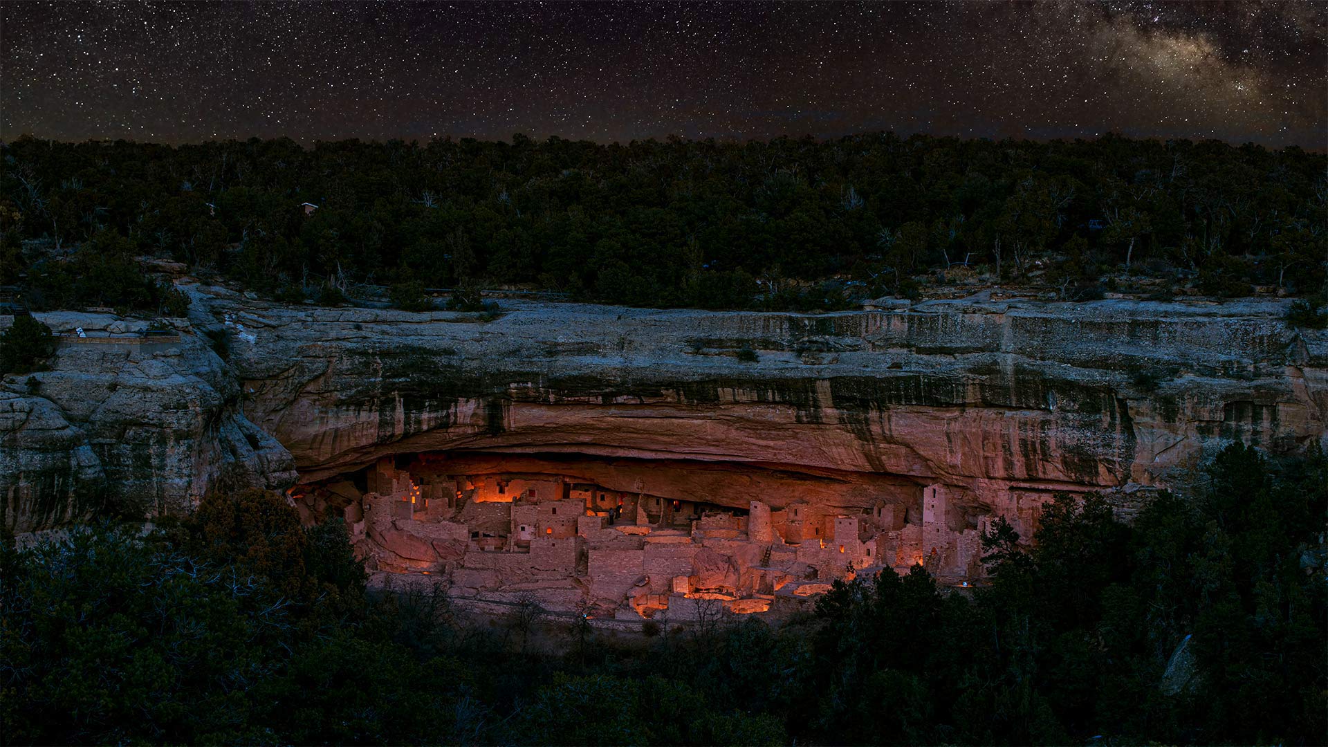
梅萨维德国家公园是普埃布洛斯祖师居住了七个世纪的地方,1978年被联合国教科文组织委员会选为首批世界遗产。
50 years of World Heritage Sites
At its World Heritage Convention on November 16, 1972, UNESCO adopted an international treaty that for the first time linked the concepts of nature conservation and preservation of cultural properties. The World Heritage Sites program was sparked by Egypt's planned construction of the Aswan High Dam, which would have flooded a large swath of the Nile Valley and thousands of archeological treasures.
Mesa Verde National Park, where Ancestral Puebloans lived for seven centuries, was among the first World Heritage Sites chosen by the UNESCO committee, in 1978.
哈尔基岛的圣约翰骑士中世纪城堡遗址,希腊 Ruins of the medieval castle of the Knights of St. John above the village of Chorio, Halki Island, Greece (© Massimo Ripani/eStock Photo)
哈尔基岛的圣约翰骑士中世纪城堡遗址,希腊 Ruins of the medieval castle of the Knights of St. John above the village of Chorio, Halki Island, Greece (© Massimo Ripani/eStock Photo)
爱琴海之巅 High above the Aegean Sea
希腊哈尔基岛上的城堡废墟
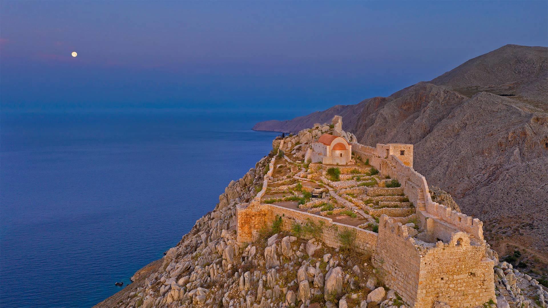
哈尔基是爱琴海中的一个希腊小岛,当你需要逃离时,你会去那里。在人迹罕至的道路上,当其他希腊岛屿挤满游客时,哈尔基安静而困倦。到达目的地的唯一途径是从大得多的罗德岛乘坐渡轮。哈尔基岛的总面积只有1100平方英里,是多德卡内塞群岛中最小的有人居住的岛屿。
哈尔基岛上最受欢迎的景点之一是这座中世纪城堡的废墟,该城堡由圣约翰骑士团于14世纪在岛上朝南的海岸上现已废弃的乔里奥村建造。从岛上唯一的城镇恩波里奥港口村出发,步行很短,很上坡,岛上数百名常住居民大多住在这里。20世纪中叶,有相当一部分人口离开,其中许多人定居在墨西哥湾沿岸的佛罗里达州塔蓬斯普林斯镇,该镇号称拥有美国所有城市中最高比例的希腊裔美国人。来自哈尔基和其他希腊岛屿的人们被引诱到塔蓬泉从事海绵潜水员的工作,这是他们在希腊世代磨练的技能。这些天,哈尔基除了吃饭、放松和游泳外,没有什么其他活动。像所有希腊岛屿一样,哈尔基有美丽的海滩。在这里,你更有可能把它们都留给自己。
Castle ruins on the island of Halki, Greece
Halki, a tiny Greek island in the Aegean Sea, is the type of place you go to when you need a getaway from your getaway. Off the beaten path, Halki is quiet and sleepy when other Greek islands are flush with visitors. The only way to arrive is by ferry from the much larger island of Rhodes. Halki has a total area of just 11, sun-kissed square miles, the smallest inhabited island in the Dodecanese island group.
One of the most popular attractions on Halki is the ruins of this medieval castle built by the Knights of St. John in the 14th century in the now abandoned village of Chorio on the island's south-facing shore. It's a short, uphill walk from the only town on the island, the port village of Emporio, where most of the island's few hundred permanent residents live. A significant portion of the population left in the mid-20th century, many of them settling in the Gulf Coast town of Tarpon Springs, Florida, which lays claim to having the highest percentage of Greek Americans of any US city. People from Halki and other Greek islands were lured to Tarpon Springs to work as sponge divers, a skill they honed for generations in Greece. These days, not much goes on in Halki beyond eating, relaxing, and swimming. Like all Greek islands, Halki has beautiful beaches. Here, you're more likely to have them all to yourself.
凯恩戈姆斯的奎奇河上的圆形凹地, 苏格兰阿伯丁郡凯恩戈姆斯 Punch Bowl on the River Quoich in the Cairngorms, Aberdeenshire, Scotland (© AWL Images/Danita Delimont)
凯恩戈姆斯的奎奇河上的圆形凹地, 苏格兰阿伯丁郡凯恩戈姆斯 Punch Bowl on the River Quoich in the Cairngorms, Aberdeenshire, Scotland (© AWL Images/Danita Delimont)
从大酒钵里喝一口 Take a sip from the Punchbowl
苏格兰阿伯丁郡的奎奇河
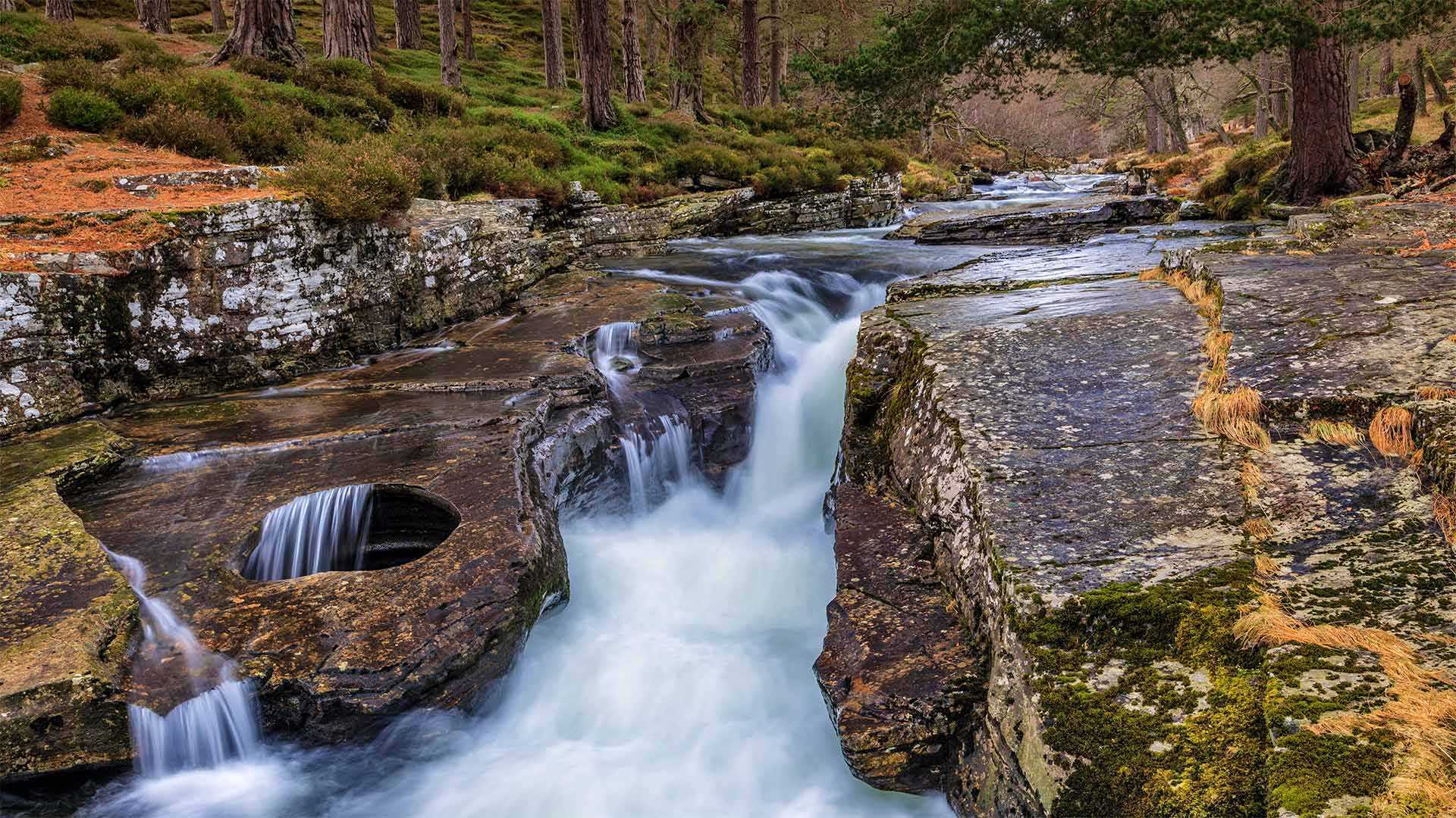
在苏格兰东部高地,一条小而受人喜爱的河流蜿蜒在凯恩戈姆山脉的森林高原上,流经一条峡谷。奎伊奇河是自然爱好者、徒步旅行者和勇敢的划桨者经常光顾的地方,他们愿意勇敢地面对它惊人的湍急水流和几处瀑布,其中就包括这里的奎伊奇林。这些瀑布以你在图片左侧看到的岩石中的碗状空洞而闻名。
这一被称为“Punch Bowl”的自然景观已成为那些游览河流并沿着河岸徒步3英里的游客的明星景点。据传说,拥有这些森林的18世纪贵族马尔伯爵会在洞顶上放一个仪式用的冲头碗,在成功猎鹿后从中喝水。英国在位时间最长的君主维多利亚女王也经常光顾这些松林,并在瀑布附近建了一座现已废弃的小屋。虽然奎奇河的美丽适合女王,但你不必成为皇室成员就可以享受它。
River Quoich in Aberdeenshire, Scotland
In the eastern Highlands of Scotland, tucked into the forested plateaus of the Cairngorms mountain range is a small but beloved river that runs through a ravine. The River Quoich is frequented by nature lovers, hikers, and intrepid paddlers willing to brave its surprisingly swift currents and its several waterfalls, including the one featured here, the Linn of Quoich. These falls are famous for the bowl-shaped cavity in the rock that you see on the left side of this image.
Called the Punch Bowl, this natural feature has become the star attraction for those who visit the river and take the 3-mile hike along its banks. According to lore, the Earl of Mar, the 18th-century nobleman who owned these woods, would place a ceremonial punch bowl atop the hole and drank from it after a successful deer hunt. Queen Victoria, Britain's longest-reigning monarch, also frequented these pine woods and built a now derelict lodge near the falls. While the beauty of the River Quoich is fit for a queen, you don't have to be royalty to enjoy it.
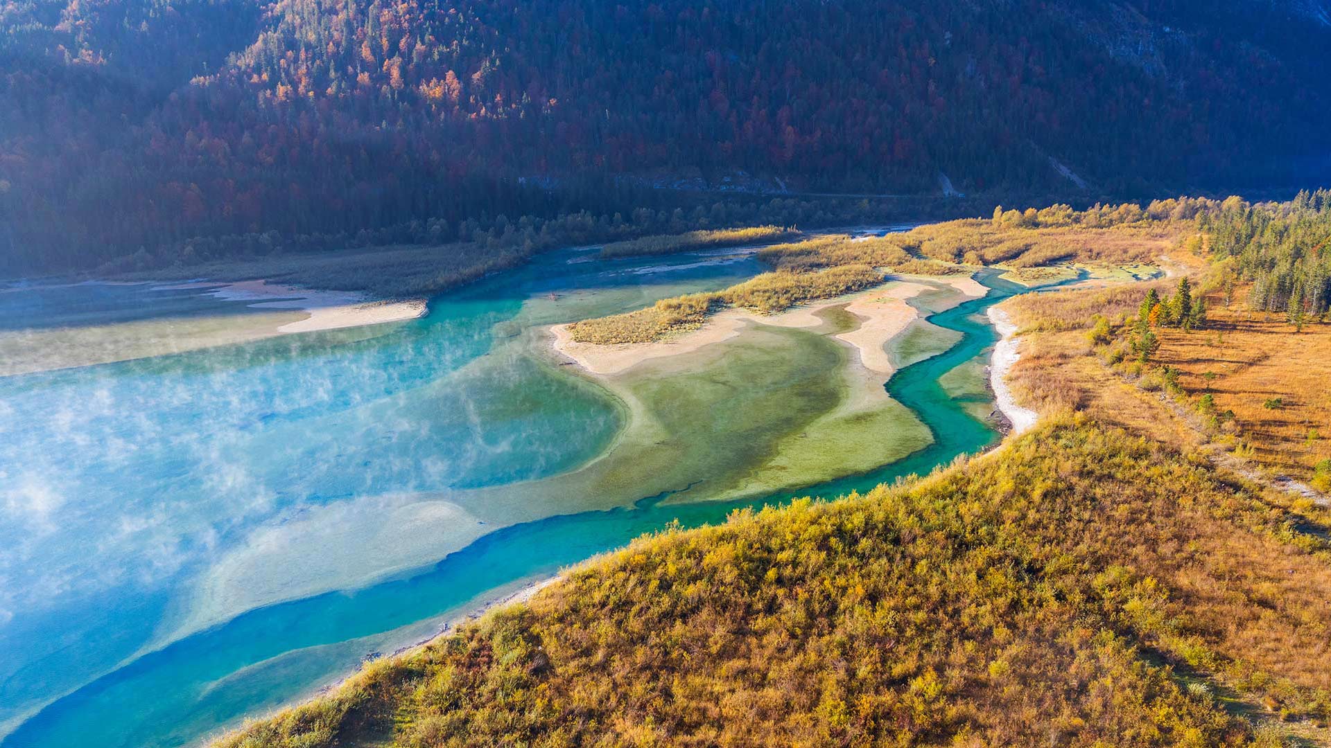
伊萨尔河鸟瞰图,德国伦格里斯 (© Martin Siepmann/Offset/Shutterstock)
阿拉瓦利山脉的阿布山,印度拉贾斯坦邦 Mount Abu and the Aravalli Range in Rajasthan, India (© saiko3p/Shutterstock)
阿拉瓦利山脉的阿布山,印度拉贾斯坦邦 Mount Abu and the Aravalli Range in Rajasthan, India (© saiko3p/Shutterstock)
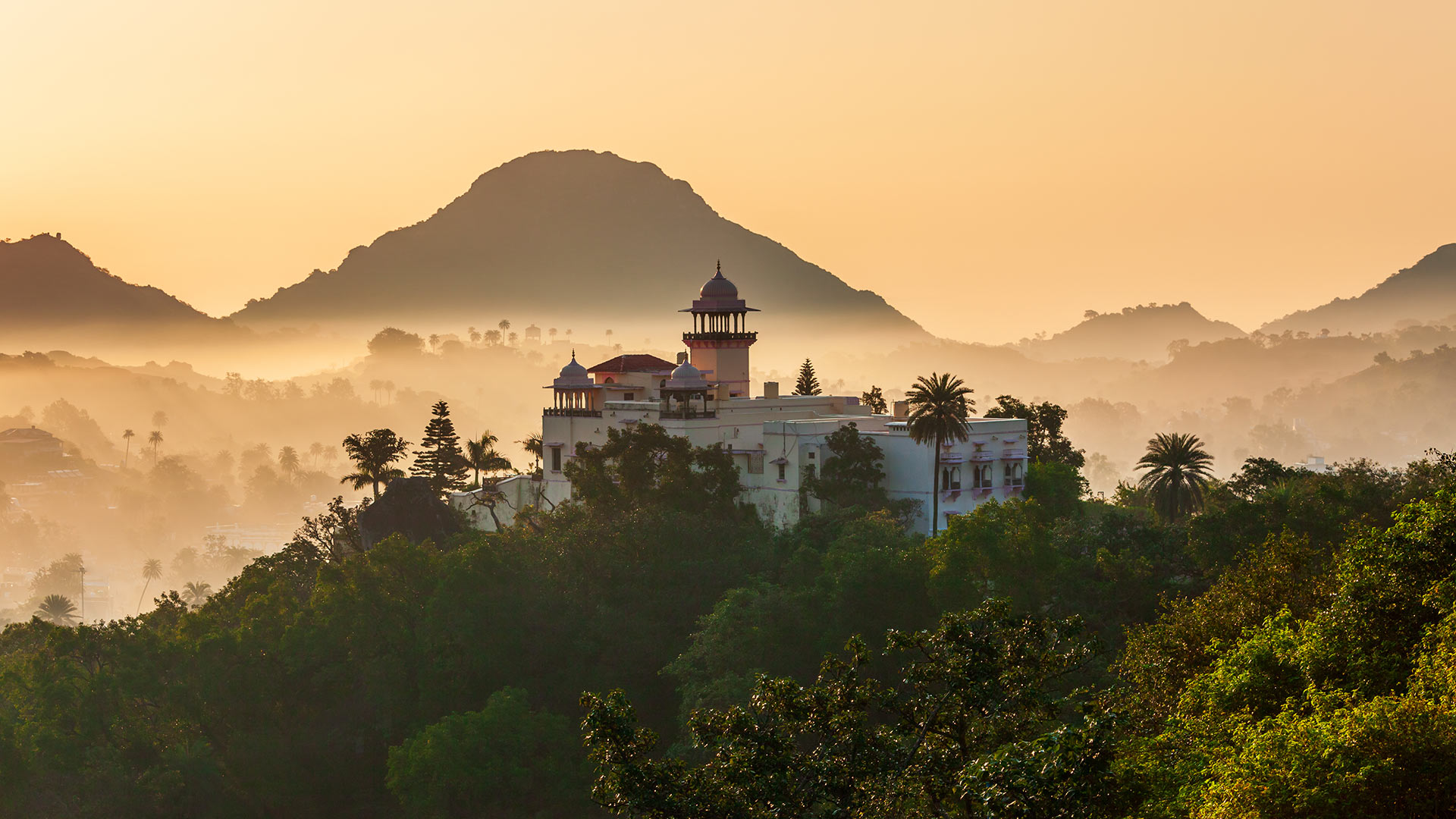
印度拉贾斯坦邦阿布山
阿布山(Mount Abu)是拉贾斯坦邦唯一的山地站,海拔1722米,被阿拉瓦利山脉(Aravalli Range)郁郁葱葱的绿色山丘环绕,为人们提供了急需的缓解拉贾斯坦斯坦酷热天气的方法。它被称为“沙漠中的绿洲”,因为它的高度是河流、湖泊、瀑布和常绿森林的家园。
阿布山由部落社区的乡村住宅和豪华住宅(包括英式平房和皇家度假屋)组成,五彩缤纷,在这个沙漠之州,阿布山似乎不亚于一个奇迹。除了风景优美之外,该地还有几座印度教和耆那教寺庙,包括Arbuda Devi Temple、Shri Raghunath Temple、Dilwara Temple等。您还可以参观附近的阿查尔加尔堡、纳基湖和德鲁迪亚瀑布。
Mount Abu, Rajasthan, India
Providing much-needed relief from the blazing heat of Rajasthan, Mount Abu, the state’s only hill station, stands at a height of 1,722 meters above sea level and is embraced by the lush green hills of the Aravalli Range. It is referred to as 'an oasis in the desert as its heights are home to rivers, lakes, waterfalls, and evergreen forests.
Studded with a colorful mix of rustic abodes of tribal communities and posh houses inclusive of British-style bungalows and royal holiday lodges, Mount Abu appears to be no less than a wonder in this desert state. Other than its scenic beauty, the place is home to several Hindu and Jain temples, including Arbuda Devi Temple, Shri Raghunath Temple, Dilwara Temple, and more. You can also visit the Achalgarh Fort, Nakki Lake, and Dhrudiya Waterfalls that are nearby.
雷暴中恶地国家公园的岩层,美国南达科他州 Rock formations in Badlands National Park during a lightning storm, South Dakota (© DEEPOL by plainpicture)
雷暴中恶地国家公园的岩层,美国南达科他州 Rock formations in Badlands National Park during a lightning storm, South Dakota (© DEEPOL by plainpicture)
恶地国家公园的一场闪电? A Bad Lightning?
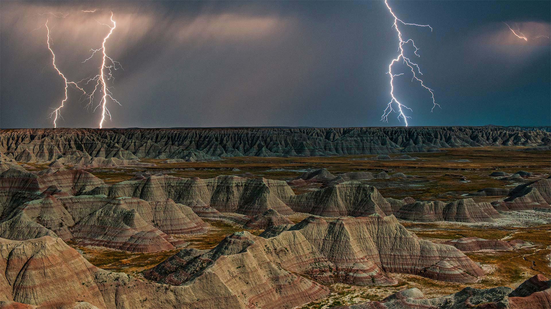
荒地国家公园
44年前的今天,南达科他州一个崎岖、荒凉的地区被指定为国家公园,以保护在陆地上发现的许多化石。该地区作为美洲原住民的狩猎场已有11000年的历史。事实上,我们今天所知道的名字Badlands来自拉科塔语“mako sica”,字面意思是“糟糕的土地”它占地近380平方英里,被严重侵蚀的岩层使它成为美国最独特的景观之一。
它还在形成!国家公园管理局表示,荒地每年侵蚀约一英寸,随着侵蚀速度的加快,侵蚀速度非常快。科学家估计,在未来50万年内,荒地将被完全侵蚀。可能想很快开始计划你的访问。
Badlands National Park
Forty-four years ago today, a rugged, inhospitable area of South Dakota was designated a national park to protect the many fossils found on the land. The area had an 11,000-year previous history as hunting grounds for Native Americans. In fact, the name we know it by today, Badlands, comes from the Lakota phrase 'mako sica,' which literally translates to 'bad lands.' Covering nearly 380 square miles, its harshly eroded rock formations make it one of the most distinct landscapes in the United States.
And it's still forming! The National Park Service says the Badlands erode about an inch every year, which is awfully fast as erosion goes. Scientists estimate that within the next half million years, the Badlands will have eroded away completely. Might want to start planning your visit soon.
庐山冬季美景,中国江西省 Beautiful winter landscape on Lushan, Jiangxi Province, China (© silkwayrain/Getty Images)
庐山冬季美景,中国江西省 Beautiful winter landscape on Lushan, Jiangxi Province, China (© silkwayrain/Getty Images)
冬天来了 The beginning of winter
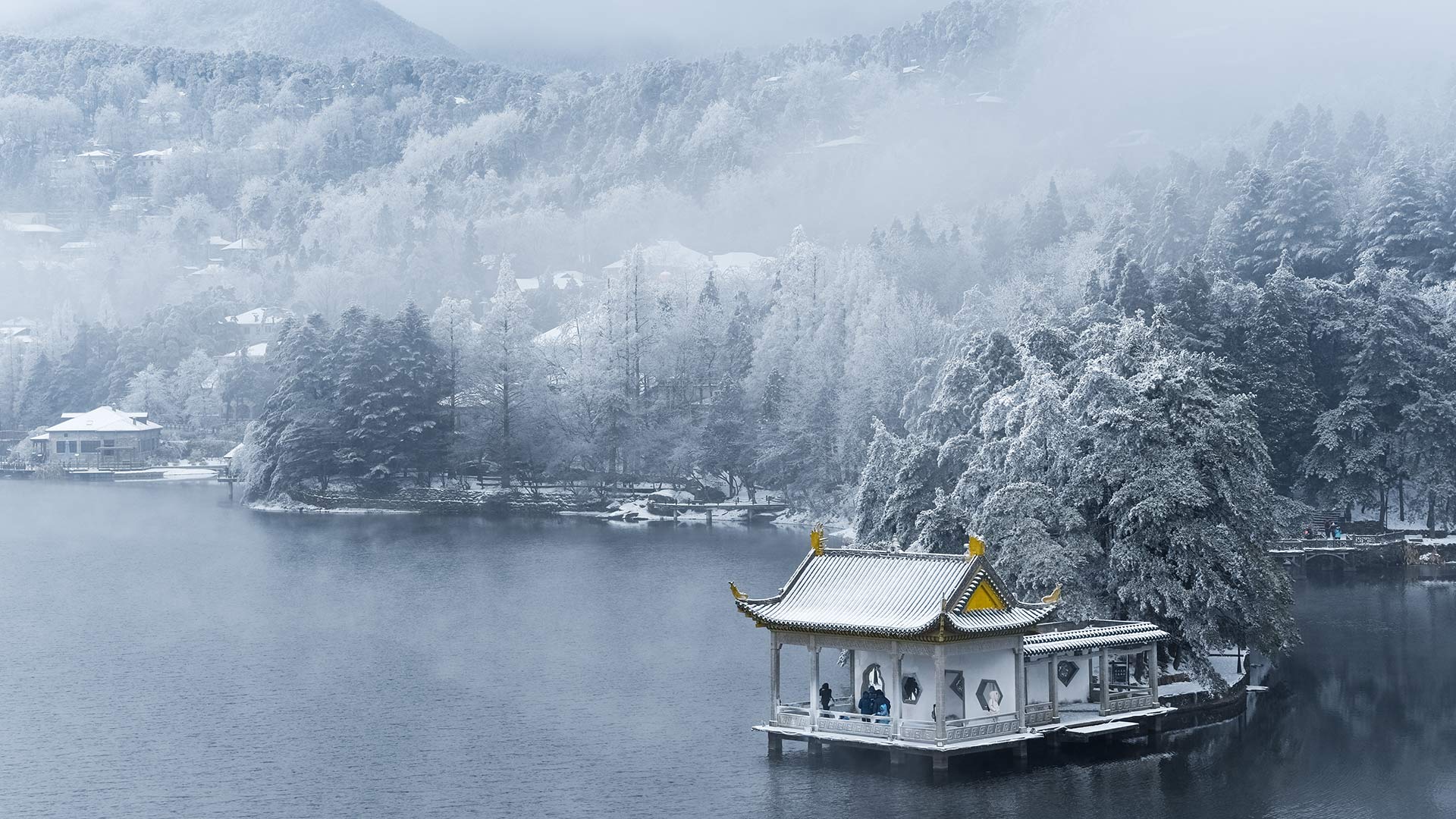
庐山冬季景观
今年11月7日是“立冬”节。立冬也是农历冬季的第一个节气。冬季的开始从11月7日或8日持续到22日或23日,与春天开始、夏天开始和秋天开始一样,它代表着一个新季节的开始。
我们仍然保持着在立冬时吃美味食物的习俗。在中国南方,鸡、鸭、鱼和其他肉类是人们的首选;在中国北方,尤其是北京和天津,人们喜欢吃饺子,象征着季节的变化。
Winter landscape on Lushan
November 7 this year is the "Start of Winter" festival. The start of Winter is also the first solar term of winter in the lunar calendar. The start of Winter lasts from November 7th or 8th to the 22nd or 23rd, and like Spring Begins, Summer Begins, and Autumn Begins, it stands for the beginning of a new season.
We still keep this custom of eating delicious food at the Beginning of winter. In south China, chicken, duck, fish, and other meats are people's first choice; in north China, especially in Beijing and Tianjin, people would like to have Jiaozi (Dumpling), signifying the change of seasons.
1990年纽约市马拉松比赛,参赛者穿过韦拉扎诺海峡大桥 Runners in the 1990 New York City Marathon crossing the Verrazzano-Narrows Bridge (© David Madison/Getty Images)
1990年纽约市马拉松比赛,参赛者穿过韦拉扎诺海峡大桥 Runners in the 1990 New York City Marathon crossing the Verrazzano-Narrows Bridge (© David Madison/Getty Images)
跑过纽约五个行政区 Racing through the five boroughs
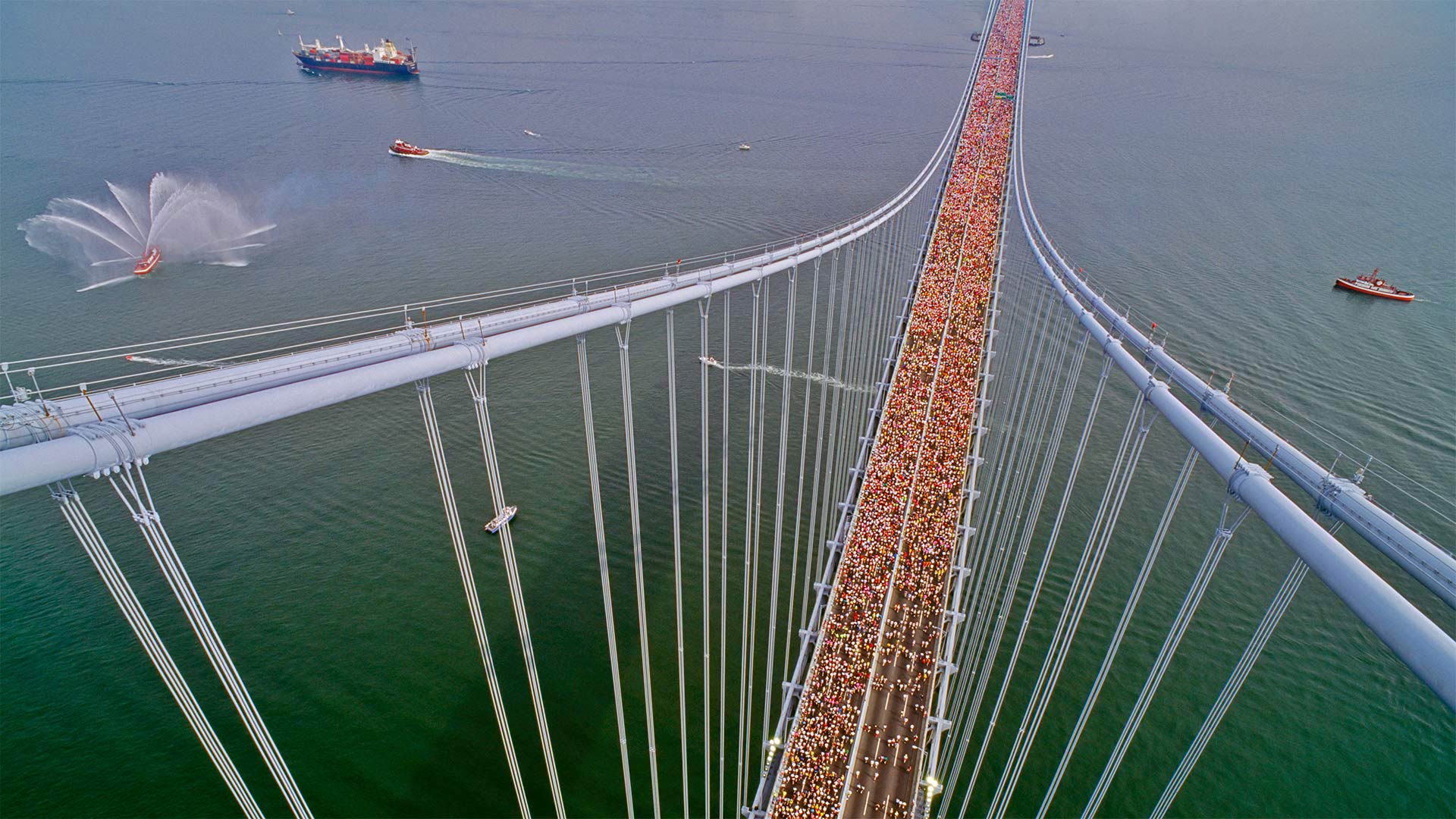
韦拉扎诺海峡大桥
2022年纽约市马拉松赛的路线就从这里开始,在韦拉扎诺海峡大桥,从斯塔顿岛(Staten Island)穿过布鲁克林(Brooklyn),最终穿过纽约的五个自治区。这张照片让你知道今天将有多少人跑步。因为比赛在11月的一个早晨很早就开始了,许多跑步者都穿着分层的衣服来抵御典型的寒冷。但一旦它们从跑步中升温,这些层就会脱落,经常被丢弃在人行道上。比赛组织者收集每年约26吨的遗留下来的运动装备,并将其捐赠给慈善机构。
Verrazzano-Narrows Bridge
The route for the 2022 New York City Marathon starts right here at the Verrazzano-Narrows Bridge, crossing from Staten Island into Brooklyn, eventually coursing through all five boroughs of New York. This photo gives you an idea of just how many people will be running today. Because the race starts early on a November morning, many runners show up in layered clothing to beat the typical chill. But once they heat up from running, those layers come off and are often discarded on sidewalks. Race organizers collect the activewear left behind, about 26 tons a year, and donate it to charity.
阿赫雷湖畔的泰莫特罗萨克斯城堡酒店,苏格兰 Tigh Mor Trossachs on Loch Achray, Scotland (© Fortunato Gatto/eStock Photo)
阿赫雷湖畔的泰莫特罗萨克斯城堡酒店,苏格兰 Tigh Mor Trossachs on Loch Achray, Scotland (© Fortunato Gatto/eStock Photo)
重温往日辉煌 Reflecting its stylish past today
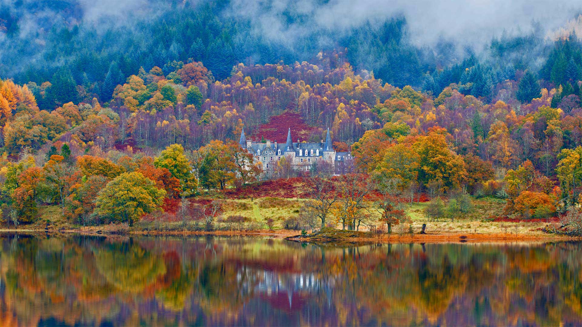
苏格兰Achray湖上的Tigh Mor Trossachs
童话城堡?检查迷人的苏格兰背景?检查平静,宁静的湖水?检查如果Tigh Mor在你看来像田园诗一样,你并不孤单。维多利亚女王在这里度过了全盛时期,尽管这座建于1849年的老酒店多年来衰落了,但耗资数百万美元的修复让它重新回到了昔日的辉煌。
Tigh Mor坐落在苏格兰特罗萨赫的Achray湖上方,这一地区的景色令人惊叹,让艺术家和画家如飞蛾扑火。作家们也受到了它的美丽的启发:早在19世纪初,沃尔特·斯科特爵士的诗歌《湖中的女士》和小说《罗布·罗伊》就激起了人们对游览这片被称为“特罗萨克斯”的森林峡谷、布雷斯和水道的兴趣
今天,许多游客徒步旅行或骑自行车游览特罗萨克斯小径,这是一条美丽的40英里长的路线,从洛蒙湖开始,蜿蜒在河流和树林中,为家庭友好的探险以及山地自行车和攀岩者带来挑战。更像一个水的人?特罗萨克人还擅长独木舟、皮划艇、桨板、帆船、游泳以及在河流和湖泊上钓鱼。
Tigh Mor Trossachs on Loch Achray, Scotland
Fairy-tale castle? Check. Stunning Scottish backdrop? Check. Calm, tranquil loch? Check. If Tigh Mor looks idyllic to you, you're not alone. Queen Victoria spent time here in its heyday, and though the old hotel (it was built in 1849) declined over the years, a multimillion-dollar restoration has brought it right back to its former glory.
Tigh Mor sits above Loch Achray in Scotland's Trossachs, a region with scenery so stunning it draws artists and painters like moths to a flame. Writers are also inspired by its beauty: Way back in the early 1800s Sir Walter Scott's poem 'The Lady of the Lake' and novel 'Rob Roy' stirred interest in visiting this area of wooded glens, braes, and waterways called 'Trossachs.'
Today many visitors hike or bike the Trossachs Trail, a beautiful 40-mile route that starts at Loch Lomond and winds along rivers and through woods, offering family-friendly adventures as well as challenges for mountain bikers and rock-climbers. More of a water person? The Trossachs are also great for canoeing, kayaking, paddle boarding, sailing, swimming, and fishing on rivers and lochs aplenty.