2022年1月
莱达尔湖, 英格兰坎布里亚郡湖区 Rydal Water in the Lake District, Cumbria, England (© Tranquillian1/iStock/Getty Images Plus)
莱达尔湖, 英格兰坎布里亚郡湖区 Rydal Water in the Lake District, Cumbria, England (© Tranquillian1/iStock/Getty Images Plus)
Rydal Water in the Lake District, Cumbria, England
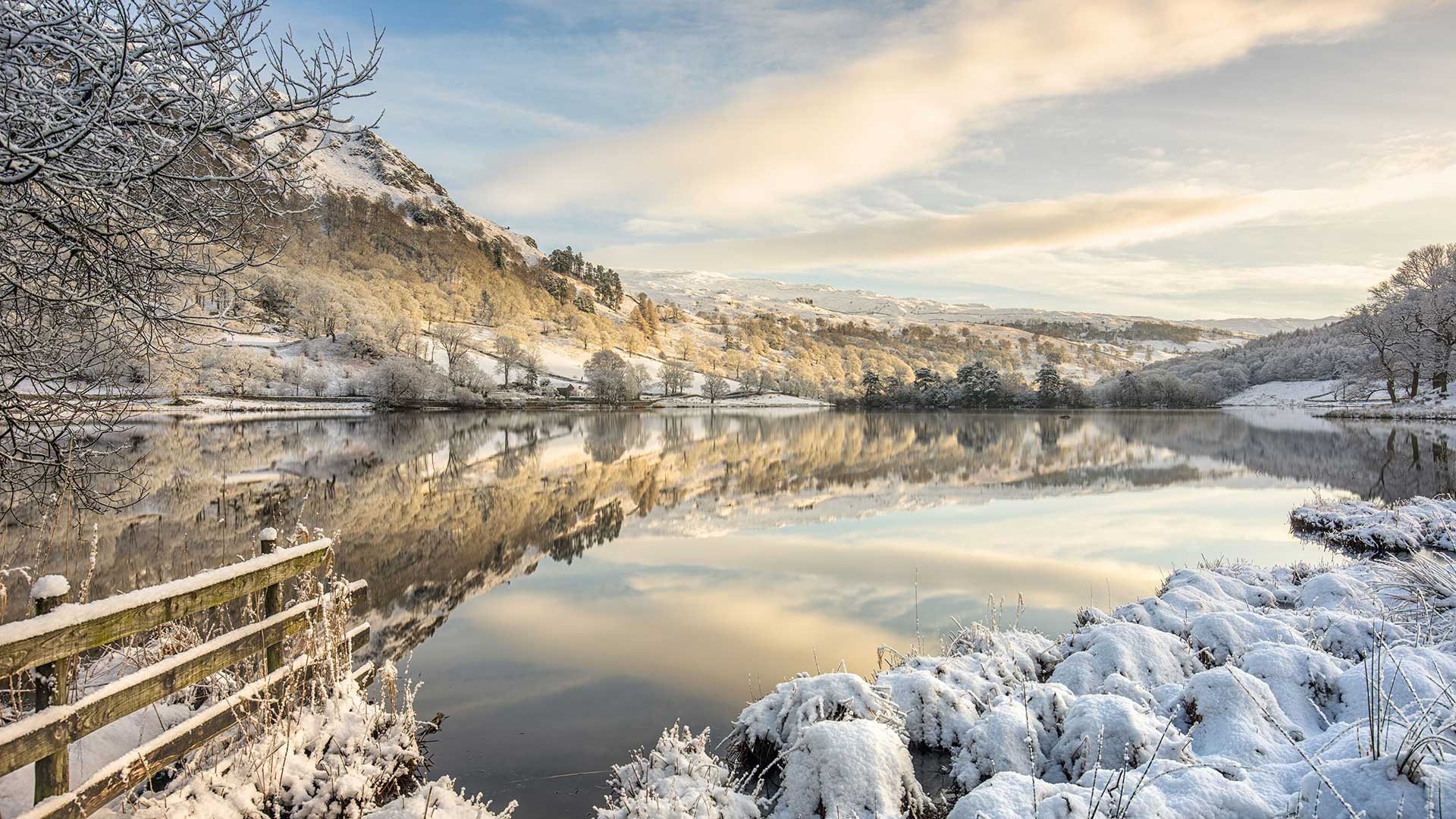
Reflecting winter skies and frozen fells in our homepage image is Rydal Water, one of the smallest but prettiest lakes in the Lake District. Rydal Water is one of the two lakes most associated with William Wordsworth, one of England’s greatest poets. (The other is neighbouring Grasmere, to which Rydal is connected by the River Rothay.) Wordsworth lived around these bodies of water, first at Dove Cottage and later Rydal Mount, between 1799 and 1850, writing some of his best-known works and hosting leading lights of the Romantic movement, including his friend, Samuel Taylor Coleridge. To the western edge of the lake is Wordsworth’s Seat, a rocky outcrop said to be the writer’s favourite spot.
Rydal Water is in a glacial valley, one of 13 valleys in the Lake District. Partly owned by the National Trust, it sits at the foot of Loughrigg Fell and has been known to freeze over on winter days like this one. You can walk around Rydal Water and take in Wordsworth’s former homes as well as passing by Rydal Cave in the hill above the lake. Surrounded by woodland, pasture and craggy fells, with several historic properties and beautifully designed landscapes, this is an inspiring place for aspiring poets, whatever the season.
英格兰坎布里亚湖区的赖德尔水
赖达尔湖是湖区最小但最美丽的湖泊之一,它反映了我们主页图像中冬季的天空和冰冻的森林。莱德尔湖是与英国最伟大的诗人之一威廉·华兹华斯联系最为密切的两个湖泊之一。(另一个是邻近的格拉斯米尔,莱德尔河与之相连。)1799年至1850年间,华兹华斯生活在这些水域周围,先是在多夫小屋,后是莱德尔山,他写了一些最著名的作品,并主持了浪漫主义运动的主要活动,包括他的朋友塞缪尔·泰勒·柯勒律治。湖的西边是华兹华斯的所在地,据说这是作家最喜欢的地方。
莱德尔河位于一个冰川峡谷中,是湖区13个山谷之一。部分归国家信托基金所有,坐落在Loughrigg Fall脚下,在像这样的冬天会结冰。你可以在莱达尔水边散步,参观华兹华斯的故居,也可以经过湖上小山上的莱达尔洞穴。这里被林地、牧场和崎岖的小林所环绕,有几处历史古迹和设计精美的景观,无论什么季节,这都是一个让有抱负的诗人感到振奋的地方。
农场上晾晒的红辣椒,孟加拉国博格拉县 Sorting chili peppers at a farm in Bogra, Bangladesh (© Amazing Aerial Agency/Offset/Shutterstock)
农场上晾晒的红辣椒,孟加拉国博格拉县 Sorting chili peppers at a farm in Bogra, Bangladesh (© Amazing Aerial Agency/Offset/Shutterstock)
Hot and Spicy Food Day
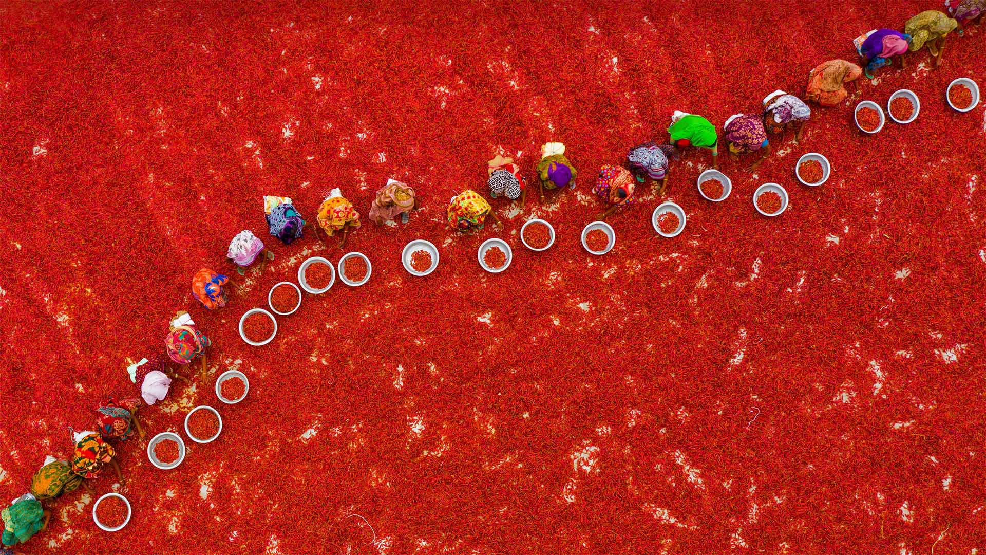
The super-spicy curries of Bangladeshi cuisine start out here in the chili fields, where workers harvest and sort red chili peppers by hand. Once picked, the peppers are sun-dried and used whole or ground to powder. The chilis not only add a flavorful kick to foods but help kill bacteria as well. Plus, hot foods actually help diners cool down: One natural reaction to capsaicin, the active chemical in chilis, is sweating, which can help chill the skin amid tropical heat.
We're visiting this chili harvest in honor of International Hot and Spicy Food Day. Whether you're already crazy for chilis or just looking to broaden your spicy-food horizons, today's the day to try that level 5 Thai curry or a burrito with habanero salsa—or if you're truly capsaicin-averse, turn up the heat with a Spice Girls or Red Hot Chili Peppers playlist.
辛辣食物日
孟加拉国菜的超辣咖喱起源于辣椒田,工人们在那里手工收割和分类红辣椒。采摘后,将辣椒晒干,整粒或磨成粉末。辣椒不仅能给食物增添香味,还能杀灭细菌。此外,热的食物实际上有助于食客降温:辣椒中的活性化学物质辣椒素的一种自然反应是出汗,这有助于在热带炎热中使皮肤降温。
为了纪念国际辛辣食物日,我们正在参观这个辣椒收获节。无论你是已经对辣椒着迷,还是只是想拓宽你对辛辣食物的视野,今天都可以尝试5级泰式咖喱或哈巴内罗沙沙卷饼,或者如果你真的不喜欢辣椒素,那就用辣妹或红辣椒播放列表来增加热度。
苏阿海沟,萨摩亚乌波卢岛南海岸 To Sua Ocean Trench on the south coast of Upolu Island in Samoa (© Chris McLennan/Alamy)
苏阿海沟,萨摩亚乌波卢岛南海岸 (© Chris McLennan/Alamy)
To Sua Ocean Trench
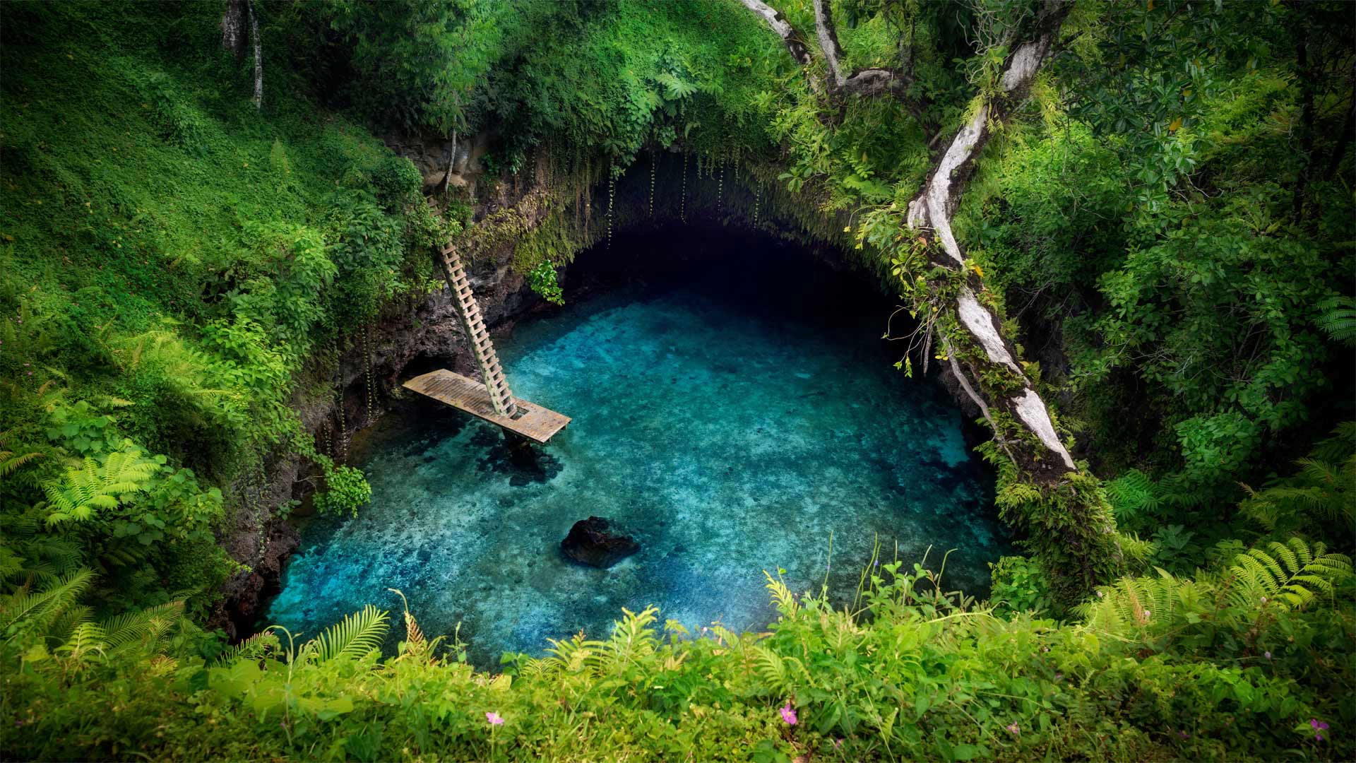
This majestic swimming hole on Samoa's Upolu Island sits just inland from the Pacific coast. It was formed when the roof of an ancient lava tube collapsed, exposing the 98-foot-deep teal-blue pool. This is the largest of many such tide pools and blow holes formed in the area many thousands of years ago. An underground cave system connects this swimming hole to the nearby ocean, and the water rises and falls with the tides.
'To Sua' translates to English as 'big hole.' While accurate, it feels like an understatement in this context. For adventurous visitors to Upolu Island, To Sua Ocean Trench can feel like a trip to another world. To get to this natural saltwater pool, make your way along a cliffside path surrounded by lush forest. Then climb down to the waters via the wooden ladder. After your swim, you can squeeze through a cave-like lava tube to find yourself on a short, sandy beach.
到苏阿海沟
萨摩亚乌波卢岛上这座宏伟的游泳池位于太平洋海岸的内陆。它是在一条古代熔岩管的顶部坍塌,露出98英尺深的蓝绿色水池时形成的。这是数千年前在该地区形成的众多潮汐池和气孔中最大的一个。一个地下洞穴系统将这个游泳洞连接到附近的海洋,海水随着潮汐涨落。
“To Sua”在英语中译为“big hole”虽然准确,但在这种情况下,这感觉像是轻描淡写。对于到乌波卢岛探险的游客来说,到苏亚海沟就像到另一个世界旅行。要到达这个天然的咸水池,请沿着一条被茂密森林环绕的悬崖边小径前进。然后通过木梯爬下水面。游泳后,你可以挤过一个洞穴状的熔岩管,发现自己在一个短的沙滩上。
通往萨卡洛布拉湾的路,西班牙马约卡岛 The road leading to Sa Calobra on the Spanish Balearic island of Majorca (© Tolo Balaguer/agefotostock)
通往萨卡洛布拉湾的路,西班牙马约卡岛 The road leading to Sa Calobra on the Spanish Balearic island of Majorca (© Tolo Balaguer/agefotostock)
Road to Sa Calobra, Majorca, Spain
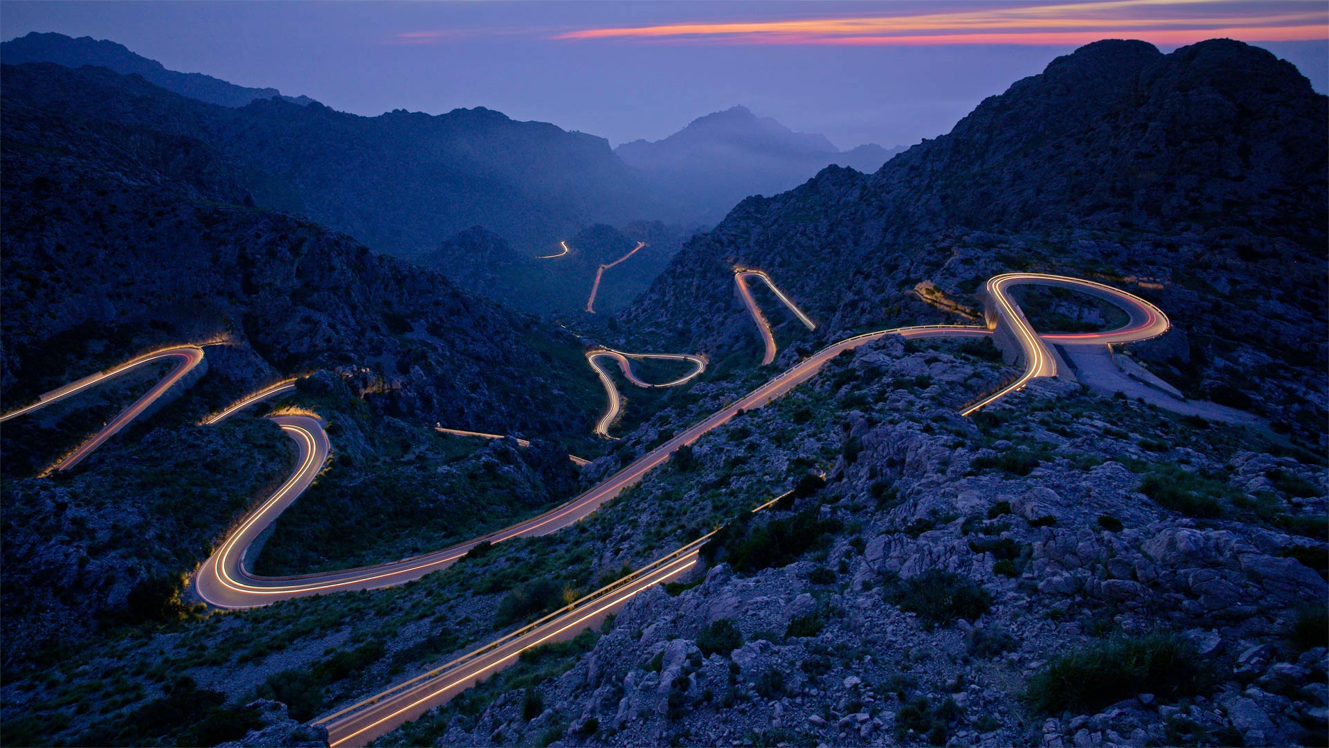
Though twists and turns abound on this road leading to Sa Calobra, on the Spanish island of Majorca, you'd have a hard time getting lost out here—there's only one road in and out of this coastal town. Rather than cut a more direct path through the mountains via tunnels, the road's designer chose to incorporate numerous switchbacks and hairpin turns, allowing sightseers to journey above ground. After all, if you make the long trip to this Mediterranean island paradise, you won't want to miss a thing—just keep an eye on the road too!
通往西班牙马略卡岛萨卡罗布拉的道路
虽然这条通往西班牙马略卡岛萨卡洛布拉的道路上有很多曲折,但你在这里很难迷路,因为进出这个海滨小镇只有一条路。这条路的设计者并没有通过隧道开辟一条更为直接的山路,而是选择了大量的转弯和发夹式转弯,让观光者可以在地面上旅行。毕竟,如果你长途跋涉来到这个地中海岛屿天堂,你不会想错过任何东西的,只要留意一下路就好了!
搁浅船只上空的极光,格陵兰岛塔西拉克 Northern lights over a stranded boat in Tasiilaq, Greenland (© Shane P. White/Minden Pictures)
搁浅船只上空的极光,格陵兰岛塔西拉克 Northern lights over a stranded boat in Tasiilaq, Greenland (© Shane P. White/Minden Pictures)
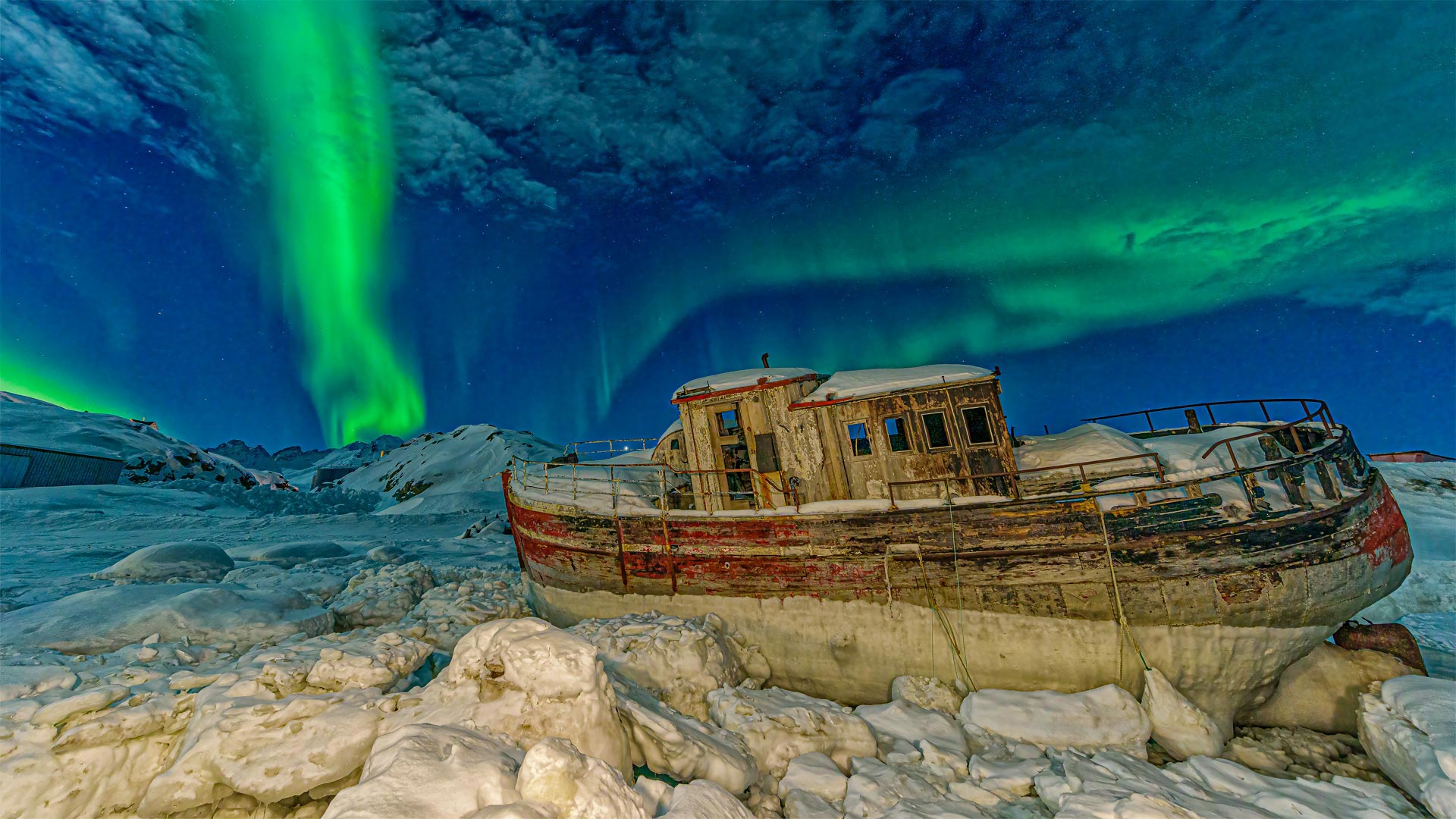
Tasiilaq, Greenland
It's said that Erik the Red gave Greenland its deceptively pleasant name to draw unwitting settlers to the snowy subcontinent. The Viking leader wasn't totally fibbing, though: Greenland can turn pretty darn green as aurora borealis gives the glaciers a glow-up.
This verdant display was captured in Tasiilaq, the largest settlement on the island's east coast. Though Tasiilaq is home to fewer than 2,000 people, it's one of Greenland's fastest-growing towns. Plus, regular plane hops from Reykjavik, Iceland—about 500 miles east—add the occasional cold-tolerant tourist to the population.
格陵兰塔西拉克
据说红色埃里克给格陵兰取了一个貌似很好的名字,以吸引不知情的定居者来到这个多雪的次大陆。尽管如此,维京人的领袖并不是完全在撒谎:当北极光使冰川发光时,格陵兰岛可以变成非常糟糕的绿色。
这张翠绿的照片是在塔西拉克拍摄的,塔西拉克是该岛东海岸最大的定居点。虽然塔西拉克的人口不到2000人,但它是格陵兰发展最快的城镇之一。此外,从冰岛雷克雅未克向东约500英里的地方定期乘坐飞机,也为当地居民增加了偶尔的耐寒游客。
梵净山,中国西南部 Mount Fanjing in southwest China (© zhuxiaophotography/Shutterstock)
梵净山,中国西南部 Mount Fanjing in southwest China (© zhuxiaophotography/Shutterstock)
Mount Fanjing
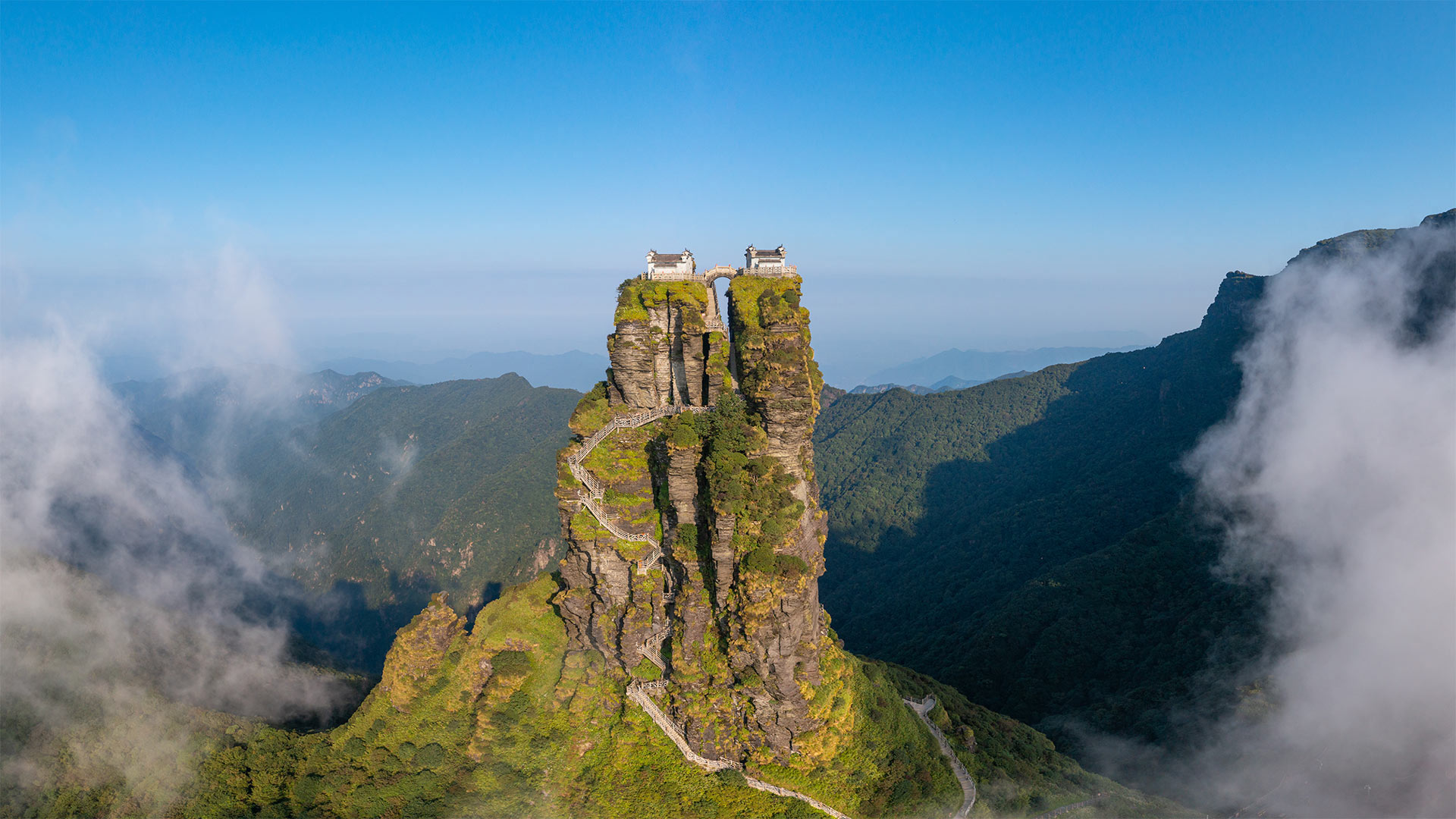
In honor of Taking the Stairs Day, we're here in China's Guizhou province peering over at Mount Fanjing. Rising more than 330 feet above the surrounding landscape, visitors will need to climb almost 9,000 steps to reach the summit. Look closely at the image and you can see how the stairs wind up, up, up around stone outcroppings and through a gorge.
The buildings you see perched at the top are two Buddhist temples—the Temple of the Buddha and the Temple of Maitreya—linked by a small footbridge. For visitors who can't fathom walking the 8,888 steps to the top, there's a cable car that will take them two-thirds of the way there. Wherever you are today, we encourage you to forego the cable car, the elevator, or the escalator, and take the stairs instead!
梵净山
为了庆祝爬楼梯日,我们来到中国贵州省,眺望梵净山。游客需要爬上近9000级台阶才能到达山顶,这一高度超过周围景观330英尺。仔细看这张图片,你可以看到楼梯是如何向上、向上、向上绕着露出地面的石头,穿过峡谷的。
你在顶部看到的建筑是两座佛教殿宇——释迦殿和弥勒殿,由一座小人行桥连接在一起。对于那些无法通过8888级台阶到达山顶的游客来说,有一辆缆车可以载他们三分之二的路程。无论你现在身在何处,我们鼓励你放弃缆车、电梯或自动扶梯,而是走楼梯!
在高地陶恩山脉的滑雪旅行,奥地利巴德加斯坦 Ski touring in the High Tauern mountain range near Bad Gastein, Austria (© RooM the Agency/Alamy)
在高地陶恩山脉的滑雪旅行,奥地利巴德加斯坦 Ski touring in the High Tauern mountain range near Bad Gastein, Austria (© RooM the Agency/Alamy)
Ski touring in Austria
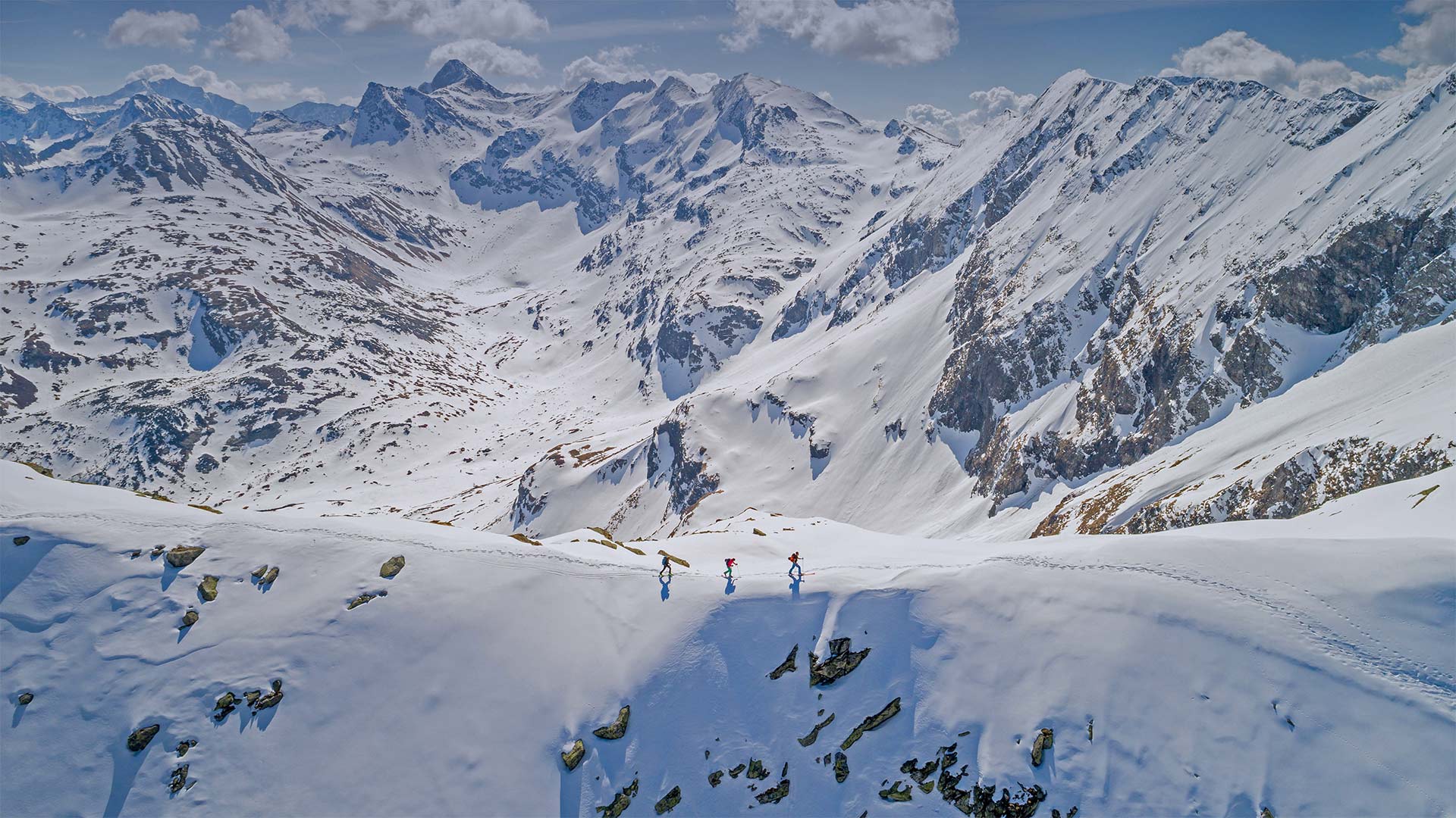
The High Tauern mountains above the Austrian spa town of Bad Gastein is one of many regions around the world that attract brave ski-touring enthusiasts, like the three skiers crossing the ridge here. Ski touring is a sport for only the most skilled athletes, since it generally involves mountaineering—navigating unfamiliar mountain territory and climbing with gear, all without removing your skis.
It's usually done off-piste, or outside the established boundaries of ski resorts. And while 'backcountry' skiers will sometimes take a ski lift or helicopter to the upper elevations, those who commit to true ski touring do the hard work themselves, as the point of ski touring is often to reach the most remote areas they can find. The skiing itself can be a combination of downhill and cross-country styles Ski touring has been around since the late 19th century but has become more popular in the past few decades.
奥地利滑雪旅游
奥地利温泉小镇巴德加斯坦(Bad Gastein)上方的陶恩山(Tauern High mountains)是世界上吸引勇敢的滑雪旅游爱好者的众多地区之一,就像三名滑雪者穿过这里的山脊一样。滑雪旅游是一项只有最熟练的运动员才能参加的运动,因为它通常包括登山、穿越不熟悉的山地和带着装备攀岩,所有这些都不需要脱下滑雪板。
通常在滑雪道外或滑雪胜地的既定边界外进行。虽然“偏远地区”的滑雪者有时会乘坐滑雪缆车或直升机前往海拔较高的地区,但那些致力于真正的滑雪旅行的人自己会做艰苦的工作,因为滑雪旅行的目的往往是到达他们能找到的最偏远的地区。滑雪本身可以是下坡滑雪和越野滑雪的结合。滑雪旅游从19世纪末就开始了,但在过去的几十年里变得越来越流行。
正在晾晒的大米,孟加拉国达卡 Rice laid out to dry in Dhamrai, Dhaka, Bangladesh (© Amazing Aerial Agency/Offset by Shutterstock)
正在晾晒的大米,孟加拉国达卡 Rice laid out to dry in Dhamrai, Dhaka, Bangladesh (© Amazing Aerial Agency/Offset by Shutterstock)
Rice processing in Bangladesh
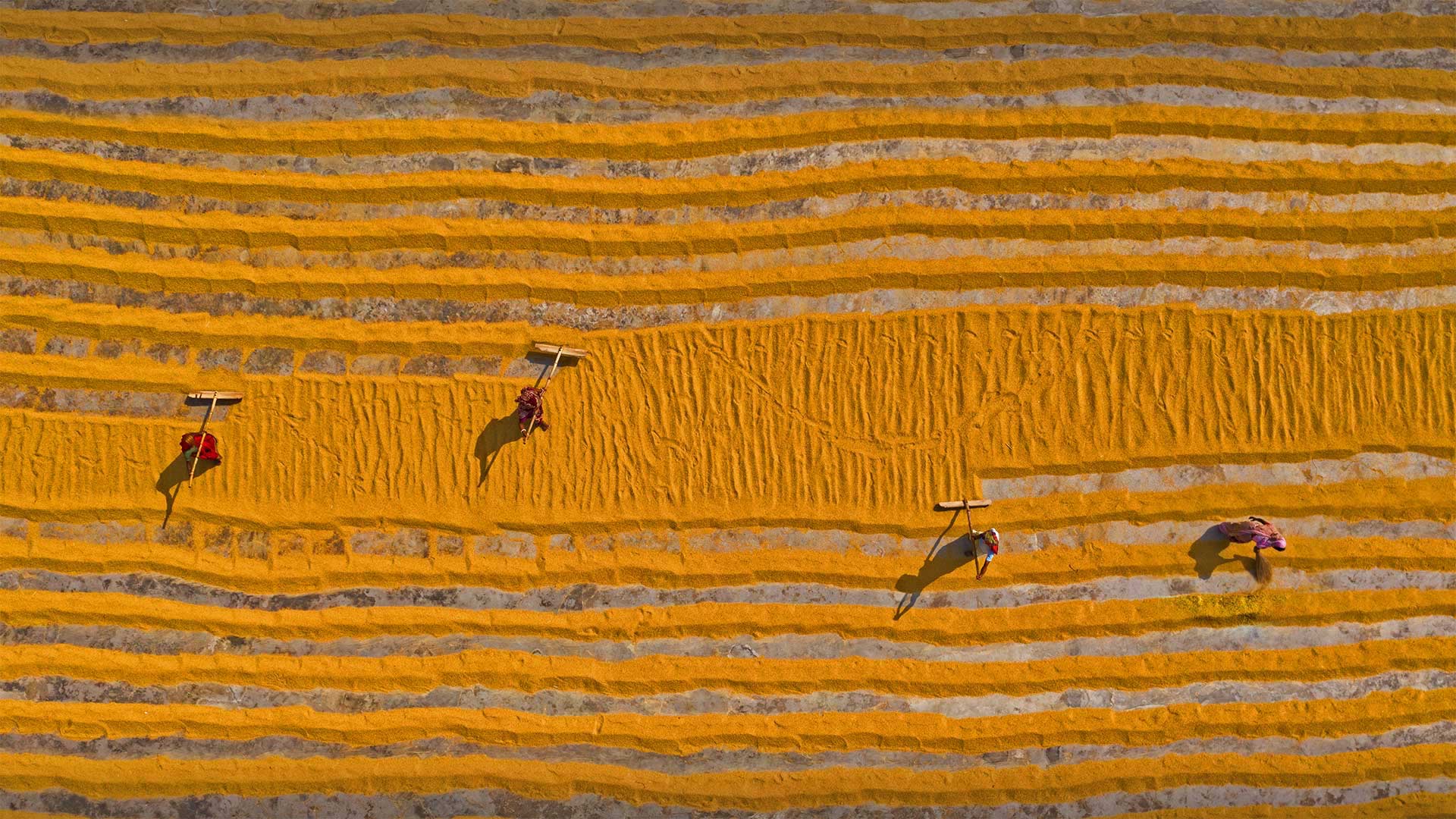
In Bangladesh, a nation that's never recorded a freezing temperature, rice growing is a year-round affair. But growing an aquatic crop in the dry season—October through March—is complicated, requiring high-yield plant strains and additional irrigation.
Drying the grains is more straightforward, though: As these workers spread rice thinly over a large field, heat from the sun warms it and the surrounding air, creating an arid environment to vaporize moisture within the grains. It's tough, toasty work—and important to boot, given that rice is the staple for the more than 160 million people who live in this South Asian nation.
孟加拉国的大米加工
在孟加拉国,一个从未记录过冰冻温度的国家,水稻种植是全年的事情。但在10月至3月的旱季种植水生作物非常复杂,需要高产植物品种和额外灌溉。
尽管如此,干燥谷物更为简单:当这些工人将大米薄薄地撒在一大片土地上时,来自太阳的热量使其和周围的空气变暖,从而创造了一个干燥的环境来蒸发谷物中的水分。鉴于大米是生活在这个南亚国家的1.6亿多人的主食,这是一项艰难、棘手的工作,而且非常重要。
纳扎雷灯塔,葡萄牙 Nazaré Lighthouse atop Forte de São, Nazaré, Portugal (© Richard A Lock/Getty Images)
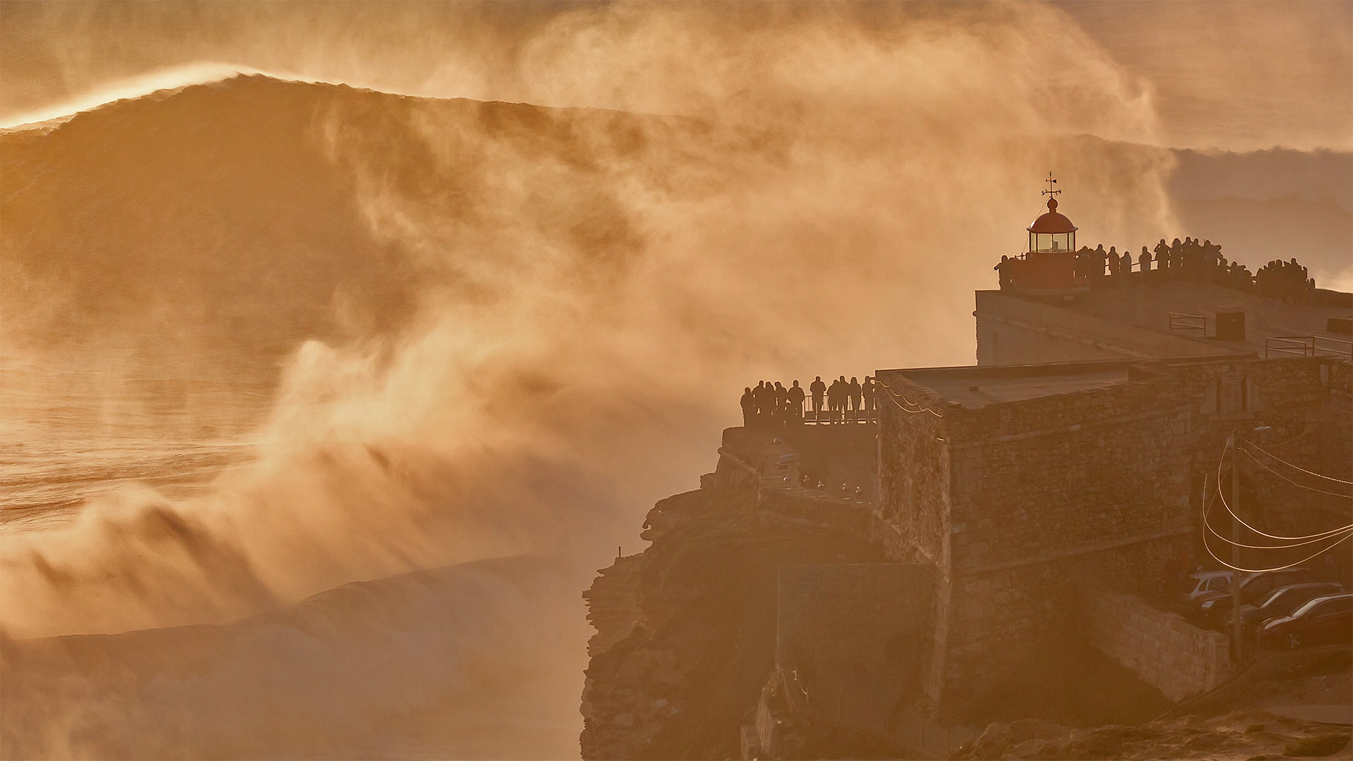
纳扎雷灯塔,葡萄牙 Nazaré Lighthouse atop Forte de São, Nazaré, Portugal (© Richard A Lock/Getty Images)
Nazaré Lighthouse
The iconic surf beaches of the world sit predominantly on the Pacific, but we're in the dead of shredding season on the Atlantic. Stormy winters from October to March beckon surfers donning their thickest wetsuits to brave gargantuan breaks here in Nazaré, Portugal. Brazilian surfer Rodrigo Koxa caught an 80-footer here in 2017, beating the previous Guinness World Record for surf wave height—also set here. Meanwhile, those less daredevilish among us are content to join this crowd standing in awe from the safety of Nazaré's Forte de São, a lighthouse-topped fortress on a shoreside cliff.
纳扎雷灯塔
世界上标志性的冲浪海滩主要坐落在太平洋上,但我们正处于大西洋破碎季节的死期。在葡萄牙纳扎雷,从10月到3月,暴风雨的冬天召唤着冲浪者穿上他们最厚的潜水服,勇敢地在这里进行巨大的休息。2017年,巴西冲浪运动员罗德里戈·科萨在这里捕获了一个80英尺高的冲浪者,打破了此前同样在这里创造的冲浪波高吉尼斯世界纪录。与此同时,我们当中那些胆小的人也很乐意加入到这群人当中,他们敬畏纳扎雷的圣堡堡(Forte de são)的安全,这是一座位于岸边悬崖上的灯塔式堡垒。
冬日里的科赫尔湖,德国巴伐利亚州 Kochelsee and Heimgarten Mountain in Bavaria, Germany (© Reinhard Schmid/eStock Photo)
冬日里的科赫尔湖,德国巴伐利亚州 Kochelsee and Heimgarten Mountain in Bavaria, Germany (© Reinhard Schmid/eStock Photo)
Kochelsee in Bavaria
To English speakers, this is Lake Kochel. To German speakers, it's Kochelsee. Whatever you call it, this popular recreation spot in Bavaria looks great all decked out in winter white. Imagine how quiet it must be when the lake is blanketed by snow. Now stretch your imagination further to the warm summer months when the shores of Kochelsee are busy with tourists out to get a dose of nature. The lake is just an hour's journey by car or train, south from the Munich. Visit during summer and you're likely to see windsurfers gliding across the surface of the lake.
巴伐利亚州的科切西
对说英语的人来说,这是科切尔湖。对说德语的人来说,这是科切西。不管你怎么称呼它,这个巴伐利亚州广受欢迎的娱乐场所穿上冬装,看起来很棒。想象一下,当湖面被雪覆盖时,一定是多么安静。现在,让你的想象力进一步延伸到温暖的夏季,科切西海岸正忙于吸引游客到这里来体验大自然。从慕尼黑以南,乘汽车或火车到这个湖只有一个小时的路程。夏季游览,你可能会看到风帆冲浪者滑过湖面。