2021年8月
杜德维卡塔拉大桥,黑山 Đurđevića Tara Bridge in Montenegro (© Hike The World/Shutterstock)
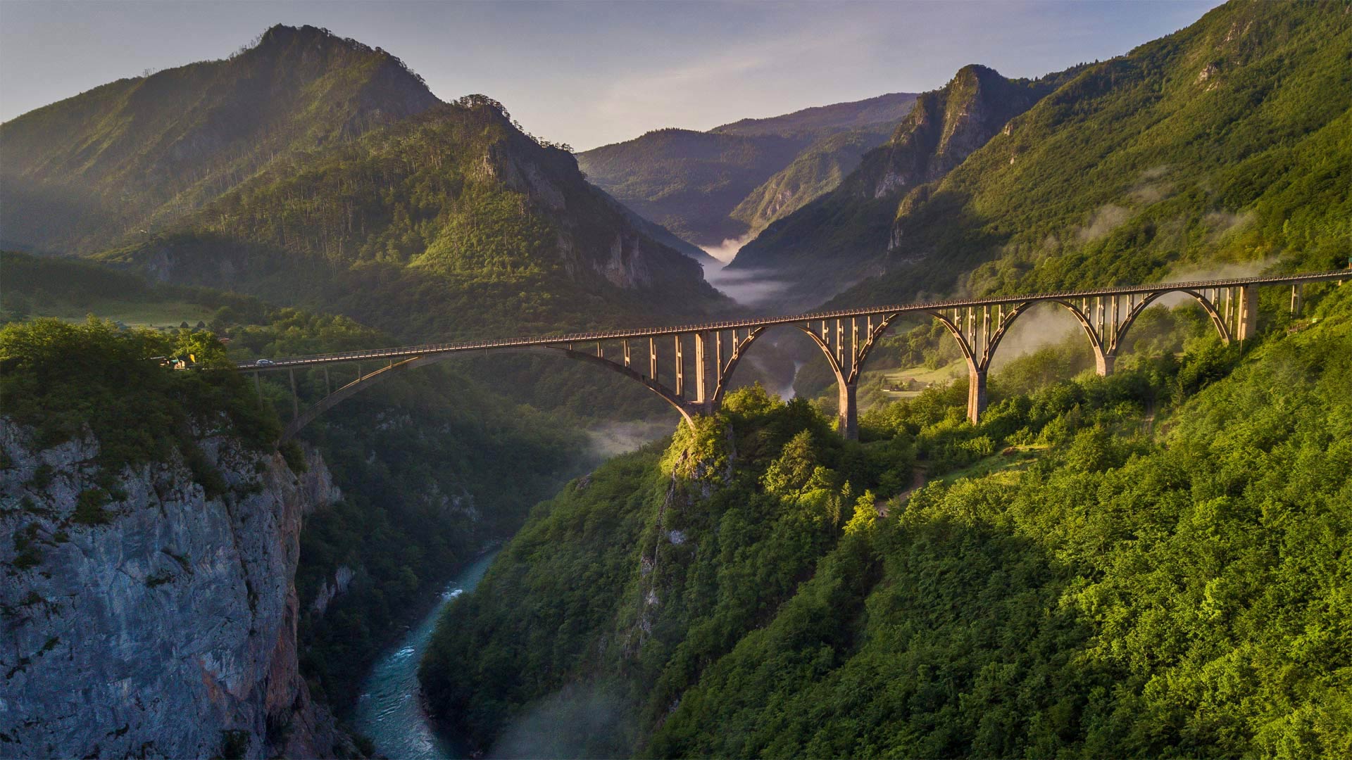
杜德维卡塔拉大桥,黑山 Đurđevića Tara Bridge in Montenegro (© Hike The World/Shutterstock)
The bridge on the River Tara
In northwestern Montenegro, the Đurđevića Tara Bridge is the fastest passage between the villages of Budečevica and Trešnjica. The five-arch concrete bridge was completed in 1940 just as World War II was spreading across Europe. By 1941, Italian forces from the Axis powers had invaded this region. Local guerrilla fighters took an extreme measure to keep the Italian army from crossing the Tara River Valley: They blew up one of the arches, making the bridge unpassable and slowing the advancement of the Axis. The bridge was rebuilt in 1946, and though it retains its original name, some still call it the anti-fascist bridge. And now you know an awesome story about a bridge in Montenegro.
塔拉河上的桥
在黑山西北部,乌尔埃维奇亚塔拉桥是Budečevica村和Trešnjica村之间最快的通道。这座五拱混凝土桥于1940年完工,当时正值第二次世界大战席卷欧洲。到1941年,轴心国的意大利军队入侵了这一地区。当地游击队战士采取极端措施阻止意大利军队穿越塔拉河谷:他们炸毁了其中一座拱门,使大桥无法通行,并减缓了轴心国的前进。这座桥于1946年重建,虽然保留了原名,但仍有人称之为反法西斯桥。现在你知道了一个关于黑山一座桥的精彩故事。
菲律宾马荣山的火山口冒烟 Crater glow from Mount Mayon in the Philippines (© Per-Andre Hoffmann/Cavan)
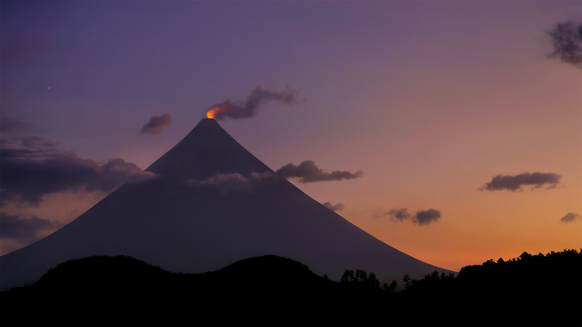
菲律宾马荣山的火山口冒烟 Crater glow from Mount Mayon in the Philippines (© Per-Andre Hoffmann/Cavan)
Behold the 'perfect' cone
How far would you have to travel for the 'perfect cone'? Well, probably not too far if you're talking ice cream. But if volcanoes are what you're looking for, you'll have to make your way to Mount Mayon on the Philippine island of Luzon. The glowing lava you see is on the tip of the world's most perfectly shaped, symmetrical volcanic cone, which formed after years of eruptions from what is still an active stratovolcano. Mount Mayon has erupted dozens of times in the past 400 years, and there was a significant eruption as recently as 2018. Even this year, smaller white steam plume emissions and faint crater glow are sometimes visible. Mayon is the most active volcano in an island nation full of active volcanos, and is located inside the UNESCO Albay Biosphere Reserve, as well as the Philippine's Mayon Volcano Natural Park. Despite its active status, tourists still flock to the park to view the unique beauty of this cone shaped spectacle.
请看“完美”圆锥体
为了“完美的圆锥体”,你需要走多远?嗯,如果你说的是冰淇淋,可能不会太远。但是如果你要找的是火山,你就得去菲律宾吕宋岛上的马荣山。你所看到的炽热的熔岩位于世界上形状最完美、对称的火山锥的顶端,这座火山锥是在多年的喷发后形成的,它仍然是一座活跃的层火山。在过去的400年中,马荣山已经喷发了几十次,最近在2018年发生了一次重大喷发。即使在今年,也可以看到较小的白色蒸汽羽流排放和微弱的火山口辉光。马荣火山位于联合国教科文组织阿尔拜生物圈保护区以及菲律宾的马荣火山自然公园内,是一个充满活火山的岛国中最活跃的火山。尽管公园处于活跃状态,游客仍然蜂拥而至,欣赏这一锥形景观的独特之美。
Ruskeala山地公园的地下湖, 俄罗斯卡累利阿 Underground lake in Ruskeala Mountain Park, Karelia, Russia (© Konstantin Trubavin/Offset by Shutterstock)
Ruskeala山地公园的地下湖, 俄罗斯卡累利阿 Underground lake in Ruskeala Mountain Park, Karelia, Russia (© Konstantin Trubavin/Offset by Shutterstock)
Notes from an underground lake
The Ruskeala Mountain Park is an eerily beautiful reminder of the booming mining industry that thrived for centuries in this area of Russia near the border with Finland. Constructed on top of an abandoned marble quarry, the park opened to the public in 2005. A centuries-old quarry that's been flooded with groundwater since the end of World War II is the park's centerpiece, although some old buildings and kilns from the mines are still intact.
Quarries in this area once extracted and exported limestone, and more importantly, marble, for use in large building projects in Russia. Catherine the Great is said to have had an affinity for the white marble that came from Ruskeala and urged its use in the construction of many of the beautiful buildings in St. Petersburgh during her 18th century reign as empress. Marble from the mines eventually ended up in famous landmarks of the city, including St. Isaac's Cathedral, St. Michael's Castle and the Marble Palace, among others. While the mines finally stopped operations in the 1990s, the park is now a popular day trip for tourists who want to learn more about the history of mining in the region.
地下湖笔记
Ruskeala山公园是一个奇异美丽的地方,它让人想起了几个世纪以来在俄罗斯与芬兰接壤的这个地区蓬勃发展的采矿业。该公园建于一个废弃的大理石采石场之上,于2005年向公众开放。一个自二战结束以来被地下水淹没的有数百年历史的采石场是该公园的核心,尽管一些旧建筑和矿山的窑炉仍然完好无损。
该地区的采石场曾经开采并出口石灰石,更重要的是大理石,用于俄罗斯的大型建筑项目。据说,凯瑟琳大帝对来自罗斯凯拉的白色大理石有着深厚的感情,在她18世纪担任皇后期间,她极力主张在圣彼得堡建造许多美丽的建筑。矿场中的大理石最终出现在城市的著名地标建筑中,包括圣艾萨克大教堂、圣迈克尔城堡和大理石宫殿等。虽然这些矿山在20世纪90年代最终停止了运营,但对于那些想更多了解该地区采矿历史的游客来说,该公园现在是一次受欢迎的一日游。
镶嵌在巨石之间的石屋,葡萄牙 Casa do Penedo (House of the Rock) in Portugal (© Olimpio Fantuz/eStock Photo)
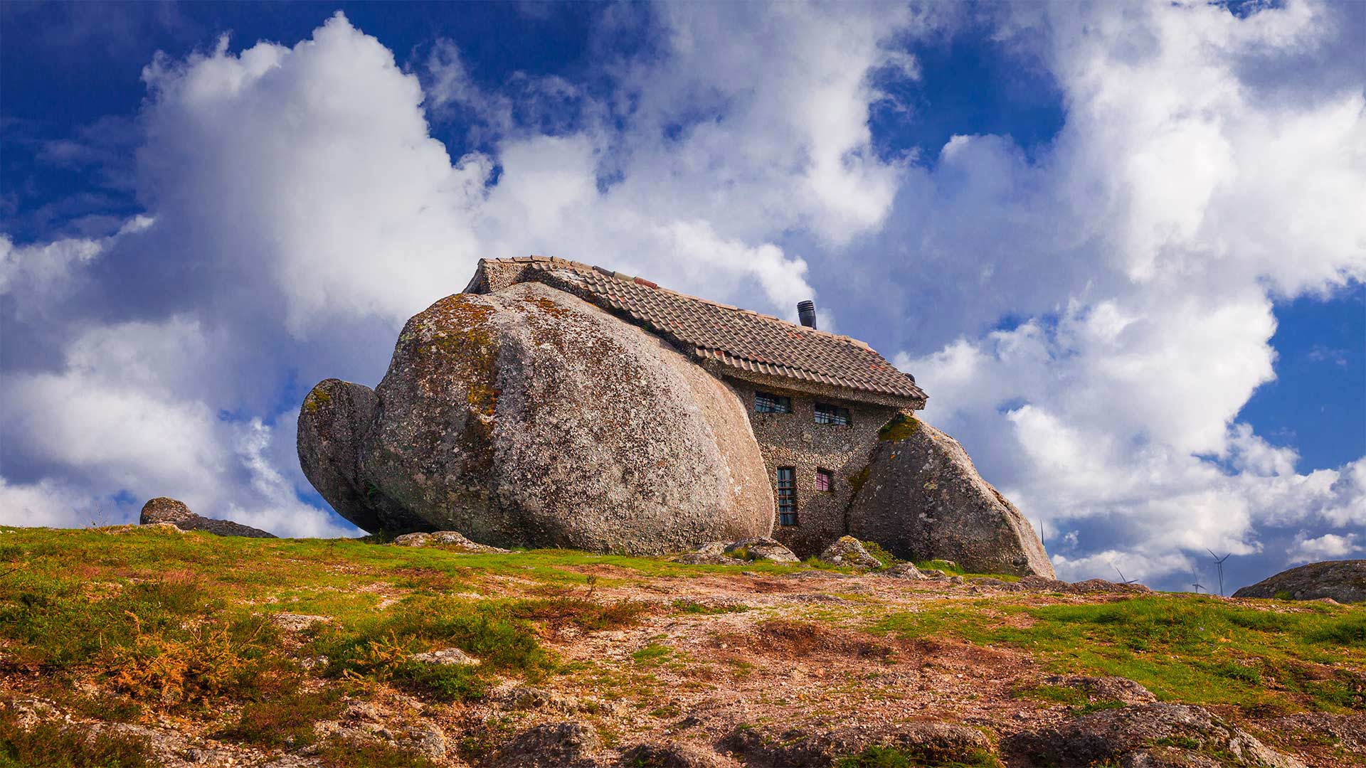
镶嵌在巨石之间的石屋,葡萄牙 Casa do Penedo (House of the Rock) in Portugal (© Olimpio Fantuz/eStock Photo)
Yabba-Dabba-Doo!
This rock-solid house in the Fafe mountains of northwest Portugal looks like it could be the home of a modern Stone Age family. Known locally as Casa do Penedo (House of the Rock), its prehistoric appearance has drawn comparisons to the Flintstones' dwelling from the fictional town of Bedrock. But the secluded stone structure on our homepage is very much real—it was built as a rural retreat in the Portuguese countryside in the 1970s. The building is sandwiched between four boulders that serve as the foundation, walls, and ceiling of the house, blending in as part of the beautiful natural landscape.
It may appear small on the outside, but inside there are two floors, comprising a kitchen, living room, bathroom, and bedrooms—just enough space for a family and their pet dinosaur. Many of the rustic fittings, including furniture, stairs, and handrails, are made of logs. There's no electricity, but there is a stone fireplace and even a small outdoor swimming pool carved out of one of the rocks. The quirkiness of the building has attracted plenty of curious visitors over the years, leaving the owners between a rock and a hard place. Due to an influx of tourists, Casa do Penedo can no longer be used as a peaceful getaway and has even been equipped with bulletproof windows and a steel door to fend off vandals. Today it functions as a small museum with relics and photographs from the house's history.
雅巴达巴嘟嘟!
这座位于葡萄牙西北部法夫山脉的坚固岩石房子看起来像是一个现代石器时代家庭的家。它的史前外观在当地被称为“岩石之屋”(Casa do Penedo),与虚构的基岩镇上的弗林茨通家的住宅相比,它的史前外观更具吸引力。但我们主页上的隐蔽的石头结构非常真实,它是1970年代在葡萄牙农村作为一个乡村休养地建造的。该建筑被夹在四块巨石之间,作为房屋的基础、墙壁和天花板,融入了美丽自然景观的一部分。
它外表看起来可能很小,但里面有两层,包括厨房、客厅、浴室和卧室,刚好足够一个家庭和他们的宠物恐龙居住。包括家具、楼梯和扶手在内的许多乡村配件都是由原木制成的。这里没有电,但有一个石制壁炉,甚至还有一个由岩石雕刻而成的小型室外游泳池。多年来,这座建筑的奇特之处吸引了大量好奇的游客,让业主们进退两难。由于大量游客涌入,佩内多之家不再能作为一个和平的避风港,甚至还配备了防弹窗和钢门来抵御破坏公物者。今天,它作为一个小型博物馆,收藏着这座房子历史上的文物和照片。
美国大峡谷北缘的天使之窗,亚利桑那州 Peekaboo view of Angels Window on the North Rim of the Grand Canyon, Arizona (© Tim Fitzharris/Minden Pictures)
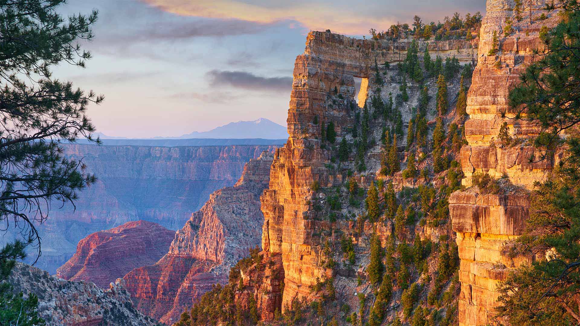
美国大峡谷北缘的天使之窗,亚利桑那州 Peekaboo view of Angels Window on the North Rim of the Grand Canyon, Arizona (© Tim Fitzharris/Minden Pictures)
Happy anniversary to the National Park Service!
On the National Park Service's Founders Day, we're here on the North Rim of Grand Canyon National Park in Arizona peering out at the stunning vista. Can you see the rectangular hole in the canyon wall near the top of the image? That's Angels Window. Brave hikers can make their way up to the trail above it, but the window itself is best viewed from various points along the North Rim. Far down below is the Colorado River. Beginning about 6 million years ago, it gradually carved downward through countless layers of sedimentary, igneous, and metamorphic rock. The Colorado and its tributary streams continue to deepen and widen the Grand Canyon even today.
The first national park, not only in the US, but also in the world, was Yellowstone, which was designated as a park in 1872. It was followed by Sequoia, Yosemite, and Mt. Rainier. While the Grand Canyon seems like an obvious choice for a national park, land and mining moguls kept it from becoming protected as a park for years. It finally became a national park in 1919, three years after the National Park Service was created on August 25, 1916. Each year on August 25, Founders Day is celebrated in all the national parks, where entrance fees are waived in honor of the occasion.
祝国家公园管理局周年快乐!
在国家公园管理局的创始人日,我们来到亚利桑那州大峡谷国家公园的北缘,眺望着令人惊叹的美景。你能看到图片顶部附近峡谷壁上的矩形洞吗?那是天使的窗户。勇敢的徒步旅行者可以爬上它上面的小径,但是从北边的各个点上看窗户本身是最好的。下面远处是科罗拉多河。从大约600万年前开始,它逐渐向下切割无数层沉积岩、火成岩和变质岩。即使在今天,科罗拉多河及其支流仍在继续加深和加宽大峡谷。
不仅在美国,而且在世界上,第一个国家公园是黄石公园,它于1872年被指定为公园。随后是红杉、约塞米蒂和雷尼尔山。虽然大峡谷似乎是国家公园的一个明显选择,但土地和矿业巨头多年来一直没有将其作为公园加以保护。1919年,在1916年8月25日国家公园管理局成立三年后,它最终成为了国家公园。每年8月25日,所有国家公园都庆祝创始人日,为纪念这一天免收入场费。
奥林匹克海岸国家海洋保护区的海岸线,美国华盛顿州 The shoreline of Olympic Coast National Marine Sanctuary, Washington state (© Chris Moore/Tandem Stills + Motion)
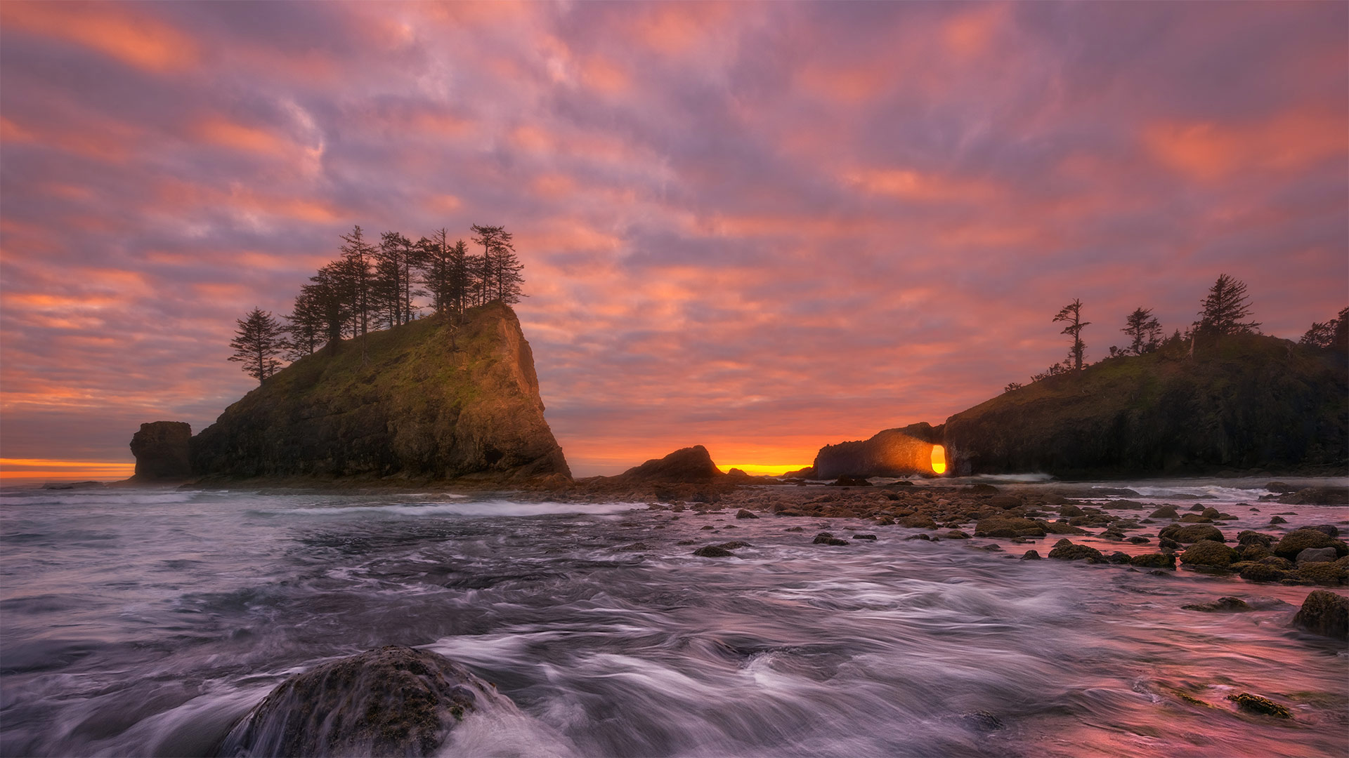
奥林匹克海岸国家海洋保护区的海岸线,美国华盛顿州 The shoreline of Olympic Coast National Marine Sanctuary, Washington state (© Chris Moore/Tandem Stills + Motion)
A wild, craggy corner of the United States
The sun is setting here on the west coast of Washington state's rugged Olympic Peninsula, where more than 3,000 square miles of marine waters are protected as part of the Olympic Coast National Marine Sanctuary. Wondering where exactly we are? Look at a map of the United States and draw your finger up the west coast until it ends where the Strait of Juan de Fuca meets the Pacific Ocean. Those final 135 miles of shoreline form the landward boundary of the sanctuary, which also extends seaward 25 to 50 miles.
This area attracts more than 3 million visitors a year. Many come to catch glimpses of the 29 species of marine mammals that reside in or migrate through this area, like humpback, gray, and orca whales, plus seals, sea lions, and sea otters. Salmon and halibut thrive here, as do any number of seabirds that make their nests in the craggy rock walls, seagrass, and treetops. At low tide, visitors explore tidepools teeming with life. This sanctuary is more than ecological resource, it's also home to vibrant Native American tribes. The Makah, Quileute, Hoh, and Quinault have been here for centuries, long before the first English sea captains spotted the coast and gave it its current name.
美国的一个荒凉、崎岖的角落
太阳落在华盛顿州崎岖不平的奥林匹克半岛西海岸,这里有3000多平方英里的海洋水域作为奥林匹克海岸国家海洋保护区的一部分受到保护。想知道我们到底在哪里?看一张美国地图,把手指指向西海岸,直到胡安·德富卡海峡与太平洋交汇处为止。最后135英里的海岸线形成了保护区的陆地边界,也向海延伸了25到50英里。
这个地区每年吸引300多万游客。许多人来这里是为了瞥见居住在该地区或迁徙经过该地区的29种海洋哺乳动物,如座头鲸、灰鲸和虎鲸,以及海豹、海狮和海獭。鲑鱼和大比目鱼在这里繁衍生息,许多海鸟也在峭壁、海草和树梢筑巢。在退潮时,游客们探索充满生命的潮滩。这个保护区不仅仅是生态资源,它还是充满活力的美洲土著部落的家园。早在第一批英国船长发现海岸并给它起了现在的名字之前,Makah、Quileute、Hoh和Quinault就已经在这里生活了几个世纪。
港边的小米努灯塔,法国布雷斯特 Petit Minou Lighthouse in the roadstead of Brest, Finistère, France (© Mathieu Rivrin/Getty Images)
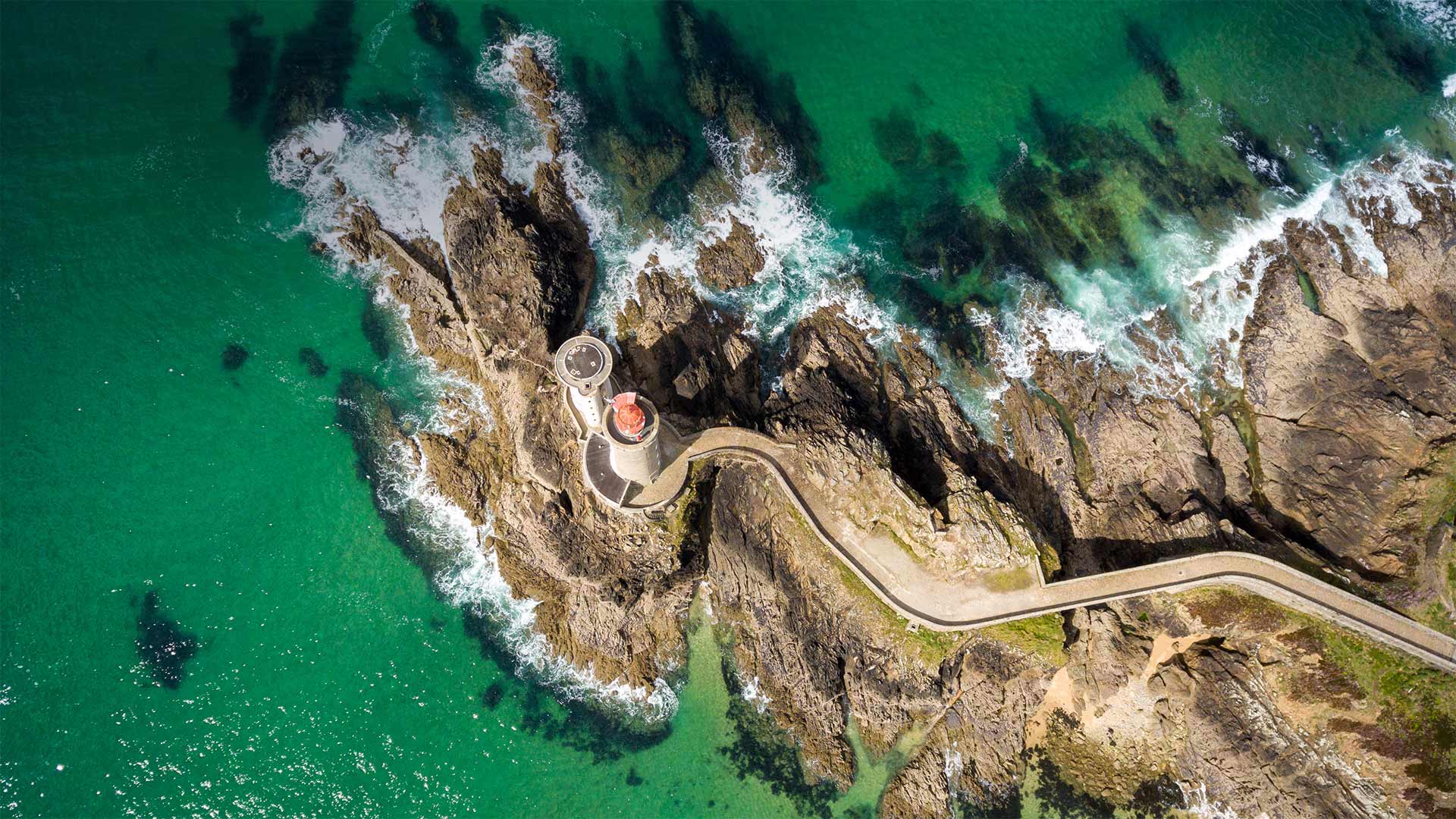
港边的小米努灯塔,法国布雷斯特 Petit Minou Lighthouse in the roadstead of Brest, Finistère, France (© Mathieu Rivrin/Getty Images)
Ambassadors of the airwaves
Today we're visiting the Petit Minou Lighthouse on the coast of northwest France to mark the relationship between lighthouses and the 20th-century technology of amateur radio, commonly known as 'ham' radio. The International Lighthouse and Lightship Weekend (ILLW) is an event set up every August by a group of amateur radio operators from nearly 100 countries. Events for this ILLW weekend are organized online with individual events held at various lighthouses around the world, where 'ham' radio operators gather to broadcast and engage with fellow enthusiasts. The aim of these gatherings is to not only foster goodwill for ham radio around the world, but also to promote awareness of lighthouse preservation and restoration, and to honor the legacy these solitary structures have had on our collective maritime heritage.
广播大使
今天,我们将参观位于法国西北部海岸的小米诺灯塔,以纪念灯塔与20世纪业余无线电技术(俗称“业余无线电”)之间的关系。国际灯塔和灯船周末(ILLW)是每年8月由来自近100个国家的业余无线电操作员组织的活动。本ILLW周末的活动在网上组织,在世界各地的灯塔举办个人活动,“火腿”电台运营商聚集在那里,与其他爱好者一起广播和参与。这些集会的目的不仅是为了在全世界培养对哈姆广播电台的善意,而且也是为了提高人们对灯塔保护和修复的认识,并纪念这些孤零零的建筑在我们的集体海洋遗产中留下的遗产。
位于阿曼和迪拜酋长国边界的鲁卜哈利沙漠 Rub' al Khali desert on the border of Oman and the Emirate of Dubai (© Daniel Schoenen/Offset by Shutterstock)
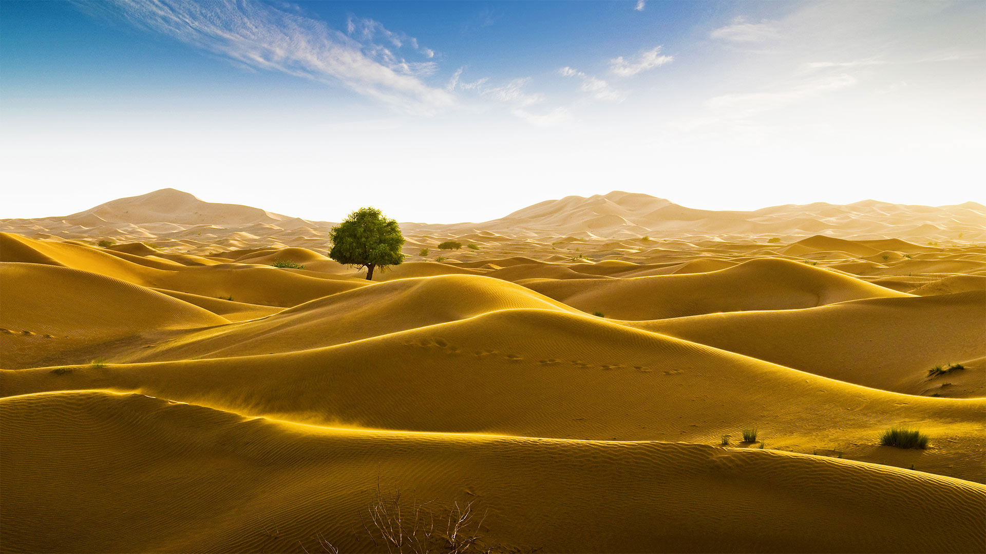
位于阿曼和迪拜酋长国边界的鲁卜哈利沙漠 Rub' al Khali desert on the border of Oman and the Emirate of Dubai (© Daniel Schoenen/Offset by Shutterstock)
Signs of life in the 'Empty Quarter'
An unlikely tree stands amid the seemingly endless dunes of the Rub' al Khali desert in the Arabian Peninsula. The Rub' al Khali, meaning the 'Empty Quarter,' is a vast sea of sand. Spreading across 250,000 square miles, it's the largest contiguous sand desert in the world, covering most of southeastern Saudi Arabia, with smaller portions in Yemen, Oman, and the United Arab Emirates. One of the driest places on Earth, almost no one lives in Rub' al Khali, and much of the desert remains unexplored. Some of the dunes tower more than 800 feet, and the depressions in between—called sabkhas—can be so soft that vehicles, camels, and people can easily become stuck.
The Rub' al Khali wasn't always so forbiddingly dry. At various times between 2,000 and 6,000 years ago, 'cataclysmic rainfall,' like modern-day monsoons, formed shallow lakes in the spaces between the dunes. Most of these lakes were temporary, but some lasted hundreds of years and supported a variety of plants and animals, even large creatures like hippopotamuses, water buffalo, and long-horned cattle. Rain isn't unheard of today, either. In May 2018, Cyclone Mekunu brought enough rain to once again form lakes in the Rub' al Khali, reportedly the first time that had happened in about 20 years—it was the rare occasion when the 'Empty Quarter' wasn't looking so empty after all.
“空旷地区”的生命迹象
阿拉伯半岛的鲁布阿勒哈利沙漠看似无边无际的沙丘中矗立着一棵不太可能的树。“鲁布”阿勒哈利,意思是“空区”,是一片广阔的沙海。它横跨250000平方英里,是世界上最大的连片沙漠,覆盖沙特阿拉伯东南部大部分地区,也门、阿曼和阿拉伯联合酋长国的面积较小。作为地球上最干燥的地方之一,鲁巴勒哈利几乎无人居住,而大部分沙漠仍未被勘探。有些沙丘高达800英尺以上,中间的洼地称为沙布喀,非常柔软,车辆、骆驼和人很容易被卡住。
阿勒哈利河并不总是那么干燥。在2000年至6000年前的不同时期,“灾难性降雨”就像现代季风一样,在沙丘之间形成了浅湖。这些湖泊大多是临时性的,但也有一些持续了数百年,供养着各种动植物,甚至还有河马、水牛和长角牛等大型动物。今天下雨也并非闻所未闻。2018年5月,梅库努气旋带来了足够的雨水,再次在鲁布阿勒哈利形成湖泊,据报道这是大约20年来首次发生,这是罕见的“空旷区”看起来不再那么空旷的情况。
杜布罗夫尼克老城,克罗地亚 The Old Town of Dubrovnik, Croatia (© Jeremy Woodhouse/Getty Images)
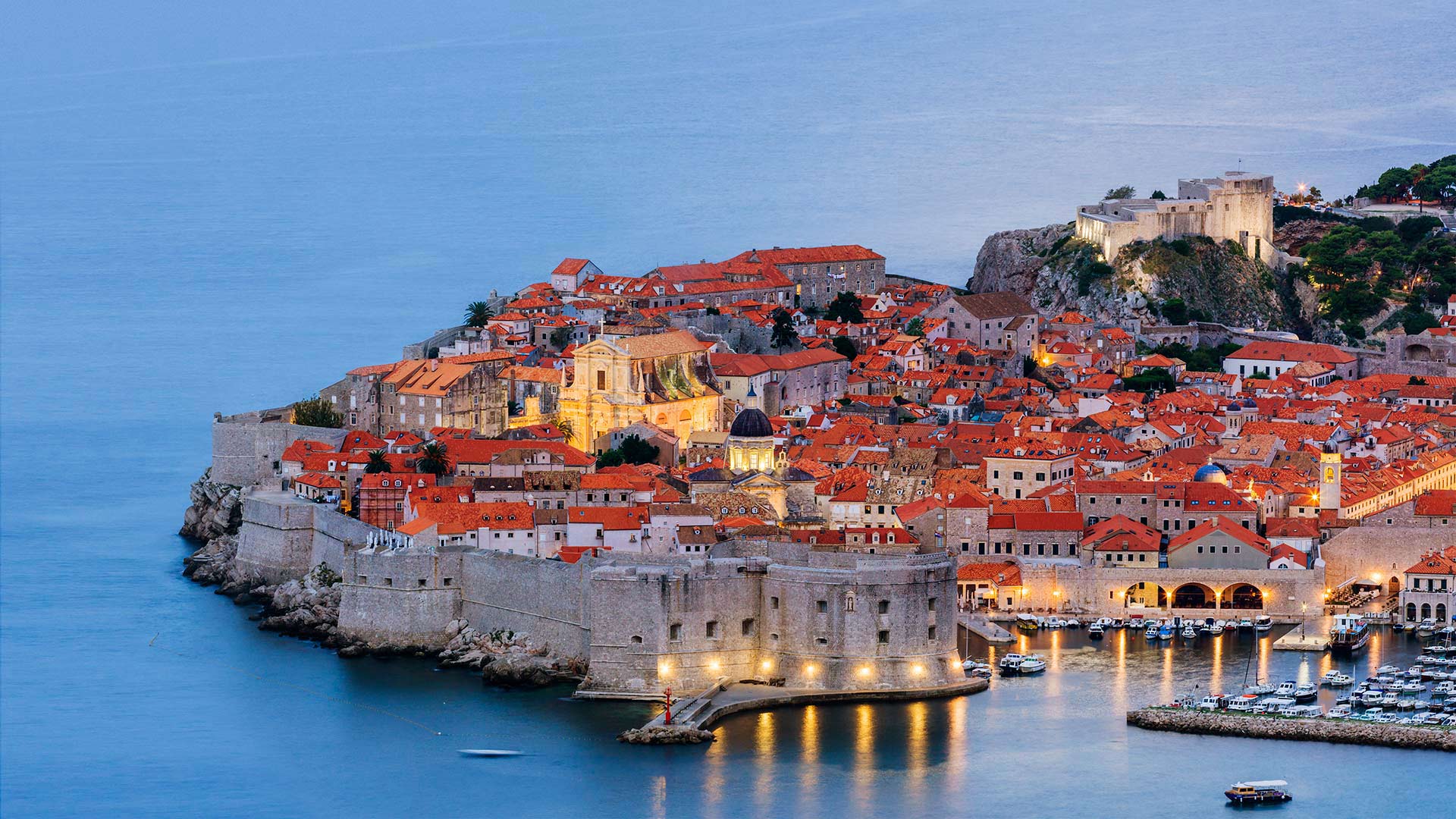
杜布罗夫尼克老城,克罗地亚 The Old Town of Dubrovnik, Croatia (© Jeremy Woodhouse/Getty Images)
Wanderin' Wawayanda
Preserving more than 35,000 acres of prime New Jersey highland wilderness, Wawayanda State Park brushes up against the state's border with New York. The park's name come from a transliteration of the Lenape Indigenous people's word for the area, said to mean 'winding water' or 'water on the mountain.' A lake and a mountain within the park are also called Wawayanda—perhaps because it's so fun to say?
In addition to the various rivers and creeks here, the park is home to 11 miles of trails, many of them covered with wooden planks. The trail in this photo is an out-and-back hike that takes visitors up to a lookout point on Wawayanda Mountain, where stunning views inspired the trail's name: Stairway to Heaven. (And now you have the Led Zeppelin song stuck in your head. You're welcome?)
漫步瓦瓦扬达
Wawayanda州立公园保护着超过35000英亩的新泽西高地荒野,与纽约州接壤。公园的名字来源于Lenape土著人对该地区的音译,据说意思是“蜿蜒的水”或“山上的水”。公园内的一个湖和一座山也被称为Wawayanda,也许是因为说起来很有趣吧?
除了这里的各种河流和小溪外,公园还有11英里长的小径,其中许多都覆盖着木板。这张照片中的小道是一次来回的徒步旅行,游客可以到达瓦瓦扬达山上的了望点,那里的美景激发了小道的名字:通往天堂的阶梯(现在,你的脑海中萦绕着齐柏林飞艇乐队的歌曲。不客气?)
天堂之路,新泽西州瓦瓦安达州立公园 Stairway to Heaven trail in Wawayanda State Park, New Jersey (© Leembe/Getty Images)
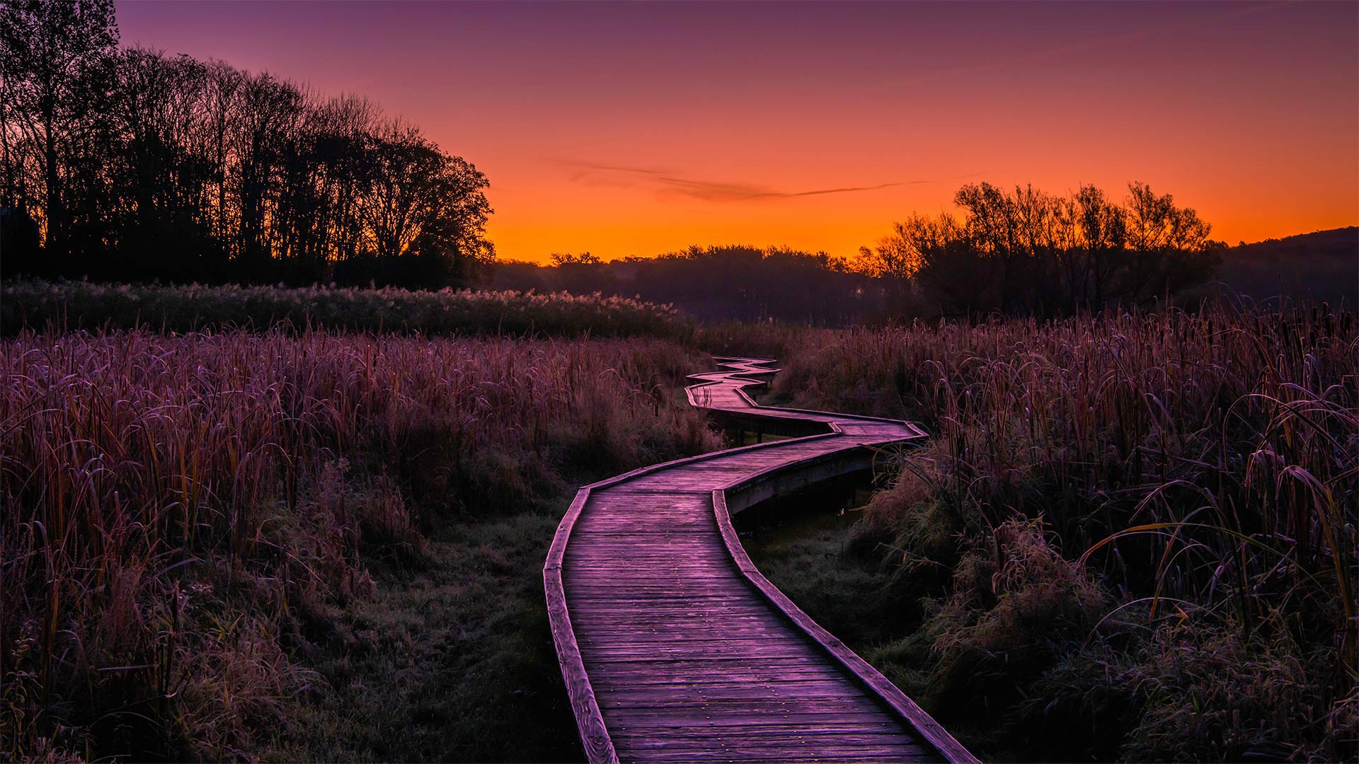
天堂之路,新泽西州瓦瓦安达州立公园 Stairway to Heaven trail in Wawayanda State Park, New Jersey (© Leembe/Getty Images)
Wanderin' Wawayanda
Preserving more than 35,000 acres of prime New Jersey highland wilderness, Wawayanda State Park brushes up against the state's border with New York. The park's name come from a transliteration of the Lenape Indigenous people's word for the area, said to mean 'winding water' or 'water on the mountain.' A lake and a mountain within the park are also called Wawayanda—perhaps because it's so fun to say?
In addition to the various rivers and creeks here, the park is home to 11 miles of trails, many of them covered with wooden planks. The trail in this photo is an out-and-back hike that takes visitors up to a lookout point on Wawayanda Mountain, where stunning views inspired the trail's name: Stairway to Heaven. (And now you have the Led Zeppelin song stuck in your head. You're welcome?)
漫步瓦瓦扬达
Wawayanda州立公园保护着超过35000英亩的新泽西高地荒野,与纽约州接壤。公园的名字来源于Lenape土著人对该地区的音译,据说意思是“蜿蜒的水”或“山上的水”。公园内的一个湖和一座山也被称为Wawayanda,也许是因为说起来很有趣吧?
除了这里的各种河流和小溪外,公园还有11英里长的小径,其中许多都覆盖着木板。这张照片中的小道是一次来回的徒步旅行,游客可以到达瓦瓦扬达山上的了望点,那里的美景激发了小道的名字:通往天堂的阶梯(现在,你的脑海中萦绕着齐柏林飞艇乐队的歌曲。不客气?)