2021年5月
奥勒松,挪威 Ålesund, Norway (© AWL Images/Offset by Shutterstock)

奥勒松,挪威 Ålesund, Norway (© AWL Images/Offset by Shutterstock)
Happy Syttende Mai!
If you have Norwegian roots, May 17, aka Syttende Mai, is a day to celebrate. On this day in 1814, the Constitution of Norway was signed, declaring Norway an independent kingdom. Today we honor this stunning country by flying over the town of Ålesund, nestled amid the mountains and fjords in the western part of the country. This seaport stretches across several islands linked by bridges and is known for its charming Art Nouveau architecture. In ordinary years, Ålesund draws hordes of tourists and serves as a gateway for visitors to explore the bird island of Runde as well as Geirangerfjord, considered one of Norway's most beautiful fjords.
祝你快乐!
如果你有挪威的根,5月17日,又名Syttende Mai,是一个值得庆祝的日子。1814年的今天,挪威宪法签署,宣布挪威为独立王国。今天,我们飞过这个令人惊叹的国家Å莱松,坐落在该国西部的群山和峡湾之中。这个海港横跨几个岛屿,由桥梁连接,以其迷人的新艺术主义建筑而闻名。平日里,Å莱松德吸引了大批游客,成为游客探索伦德鸟岛以及被认为是挪威最美丽峡湾之一的盖兰热峡湾(Geirangerfjord)的门户。
鸟瞰瓜塔佩巨岩,哥伦比亚瓜塔佩 Aerial view of El Peñón de Guatapé, Guatapé, Antioquia, Colombia (© Amazing Aerial Agency/Offset by Shutterstock)

鸟瞰瓜塔佩巨岩,哥伦比亚瓜塔佩 Aerial view of El Peñón de Guatapé, Guatapé, Antioquia, Colombia (© Amazing Aerial Agency/Offset by Shutterstock)
A magnificent monolith
Towering more than 650 feet, El Peñón de Guatapé (The Rock of Guatapé) is an inselberg, which is geologist-speak for a stone monolith that stands alone amid relatively flat surroundings. This huge rock is found in northwest Colombia, a region once inhabited by indigenous Tahamí people, who are said to have worshipped El Peñón, as many locals now call it. Probably because it's so smooth, no one is known to have climbed the rock until 1954, when a small group of friends scaled it by wedging a series of boards into a vertical crack. It took them five days to reach the top.
These days El Peñón is considerably easier to climb, but it'll still make you work for that view at the top. Into the same crack the climbers used back in '54, a masonry staircase now makes several switchbacks all the way to the summit. Each of the 740 stairs is numbered, so you can be reminded with each step just how many more remain before you arrive at the viewing platform up top.
宏伟的巨石
高达650英尺,瓜塔佩岛 (瓜塔佩之岩) 是一个孤山,这是地质学家所说的在相对平坦的环境中独立存在的一块石头。这块巨石发现于哥伦比亚西北部,该地区曾是土著塔哈姆人的聚居地í 据说崇拜艾尔佩的人ñón、 正如许多当地人现在所说。可能是因为它太光滑了,直到1954年,一小群朋友用楔子把一系列木板塞进一条垂直的裂缝里,才知道有人爬上过这块岩石。他们花了五天时间才到达顶峰。
这些天埃尔佩ñón是相当容易攀登,但它仍然会使你在顶部的看法工作。在54年登山者使用过的同一条裂缝中,一个石质楼梯现在可以在通往山顶的路上进行多次转换。740个楼梯中的每一个都有编号,因此在您到达顶部的观景台之前,每一步都可以提醒您还有多少楼梯。
帕瑞纳天文台的望远镜和星迹,智利阿塔卡马沙漠 Telescopes and star trails at Paranal Observatory, Atacama Desert, Chile (© Matteo Omied/Alamy)

帕瑞纳天文台的望远镜和星迹,智利阿塔卡马沙漠 Telescopes and star trails at Paranal Observatory, Atacama Desert, Chile (© Matteo Omied/Alamy)
Happy Astronomy Day!
No, that's not a downpour of lightsabers—but it's no typical night sky either. Stargazing here at Paranal Observatory, on a mountaintop in Chile's desolate Atacama Desert, you'll get one of the clearest possible naked-eye views of the southern skies. This 'lightsaber' effect comes from the photo's long exposure: What we're seeing is these stars' paths as they track across the night sky due to our planet's rotation. The dazzling colors indicate temperature, from chilly red (5,000-ish degrees Fahrenheit) to balmy blue (temps in the tens of thousands).
What about those structures beneath the starry sky? They're three of the eight telescopes making up the Very Large Telescope, an aptly named project of the European Southern Observatory. Together the telescopes compose photographs of astronomically fine focus: If you were to drive a car on the surface of the moon (which we don't advise trying), the VLT could snap a crystal-clear shot of your headlights.
天文学节快乐!
不,那不是一场光剑雨,但也不是典型的夜空。在智利荒凉的阿塔卡马沙漠的山顶上,你可以用肉眼看到最清晰的南方天空。这种“光剑”效应来自于照片的长时间曝光:我们看到的是由于我们星球的自转,这些恒星在夜空中的轨迹。耀眼的颜色表示温度,从冷红色(5000华氏度)到温和的蓝色(数万华氏度)。
星空下的那些建筑呢?它们是组成超大型望远镜的八个望远镜中的三个,这是欧洲南方天文台的一个恰当命名的项目。这些望远镜一起组成了天文上精细聚焦的照片:如果你在月球表面驾驶一辆汽车(我们不建议你尝试),VLT可以拍下你的头灯的清晰照片。
上弗洛雷斯塔附近晨雾中亚马逊雨林,巴西马托格罗索 Amazon rainforest with fog in the morning near Alta Floresta, Mato Grosso, Brazil (© Pulsar Imagens/Alamy)

上弗洛雷斯塔附近晨雾中亚马逊雨林,巴西马托格罗索 Amazon rainforest with fog in the morning near Alta Floresta, Mato Grosso, Brazil (© Pulsar Imagens/Alamy)
A misty morning in Brazil
The Amazon rainforest is big. Almost unimaginably big. To begin to grasp its immensity, consider these numbers: The Amazon rainforest covers about 2% of the world's surface area, nearly 2.1 million square miles across South America, mostly (nearly 60%) in the country you see here, Brazil. It's an area that accounts for over half the Earth's remaining rainforests. The breadth of biodiversity is incomparable–nearly 16,000 different tree species, 40,000 species of other plants, 2.5 million insect species, and over 2,000 different types of birds and mammals. Incredibly, perhaps a tenth of the planet's known species call the Amazon home, many of which have not even been identified.
Yet, despite its vastness and ecological riches, the Amazon and the world's rainforests in general are in jeopardy, with large swaths of these precious environments being stripped and spoiled every day. Recent analysis has revealed some ominous warning signs that the Amazon rainforest, long known as the 'Lungs of the World,' is now spewing out as much greenhouse gas as it can store because of rampant deforestation here. If true, this is a bad sign in our battle against climate change. Hopefully, these warnings will raise awareness about the importance of rainforests, and the vital 'carbon sink' role they play in creating and maintaining the air that we breath. The more we learn about rainforests, the more we appreciate how our own future, and the future of our planet, hinges upon their health.
巴西雾蒙蒙的早晨
亚马逊雨林很大。几乎难以想象的大。要开始理解它的浩瀚,考虑一下这些数字:亚马逊雨林覆盖了大约2%的世界表面积,几乎210万平方英里横跨南美洲,大部分(近60%)在你看到的国家,巴西。这个地区占了地球剩余雨林的一半以上。生物多样性的广度是无与伦比的——将近16000种不同的树种,40000种其他植物,250万种昆虫,2000多种不同类型的鸟类和哺乳动物。令人难以置信的是,地球上大约十分之一的已知物种称亚马逊为家,其中许多物种甚至还没有被确认。
然而,尽管亚马逊地区幅员辽阔,生态资源丰富,但它和整个世界的雨林都处于危险之中,大片宝贵的环境每天都被剥夺和破坏。最近的分析揭示了一些不祥的警告信号,长期以来被称为“世界之肺”的亚马逊雨林,由于这里森林砍伐猖獗,现在正喷出尽可能多的温室气体。如果这是真的,那么这是我们应对气候变化斗争中的一个坏迹象。希望这些警告能提高人们对雨林重要性的认识,以及它们在创造和维持我们呼吸的空气中所起的重要“碳汇”作用。我们对雨林了解得越多,我们就越了解我们自己的未来,以及我们星球的未来如何取决于它们的健康。
美瑛町的四季彩之丘,日本 Shikisai no Oka flower gardens in Biei, Japan (© Tanya Jones/Shutterstock)

美瑛町的四季彩之丘,日本 Shikisai no Oka flower gardens in Biei, Japan (© Tanya Jones/Shutterstock)
Hues of Hokkaido
The Japanese prefecture of Hokkaido is known the world over as a winter wonderland. But once the snow melts, it's not long before the northerly island becomes a summery extravaganza of color. Just outside the town of Biei in central Hokkaido's hilly highlands, gardeners cultivate a rainbow blanket of tulips, lupine, marigolds, dahlias, and many more flowering plants. So wide is the assortment here at Shikisai no Oka (meaning 'Hills of Seasonal Colors') that if you visit between April and October, you're sure to find at least one type of flower in full bloom.
北海道的色调
日本北海道县被全世界称为冬季仙境。但一旦雪融化,不久,北风岛就变成了夏季色彩的盛宴。就在北海道中部丘陵高地的碧井镇外,园丁们种植着一片彩虹般的郁金香、羽扇豆、万寿菊、大丽花和更多的开花植物。Shikisai Nooka(意为“季节性色彩的山丘”)的品种繁多,如果你在4月至10月期间造访,你肯定会发现至少有一种花开得很茂盛。
香浓河对岸的景色,爱尔兰利默里克 A view across the River Shannon in Limerick, County Limerick, Ireland (© Piotr Machowczyk/Shutterstock)

香浓河对岸的景色,爱尔兰利默里克 A view across the River Shannon in Limerick, County Limerick, Ireland (© Piotr Machowczyk/Shutterstock)
A visit to Limerick on Limerick
Today is Limerick Day, and what better place to celebrate this unofficial holiday than in Limerick, Ireland. The connection between the historic city and the humorous, five-line verse is unclear. Several theories have been purported, none of them definitive. But the city of Limerick has embraced its namesake poetry style and in recent years the Limerick Writers' Centre has hosted an annual competition called Bring Your Limericks to Limerick.
We're looking across the River Shannon at the historic part of the city, a medieval section once walled off by the Vikings around 812 and known today as King's Island. That's King John's Castle on the left, built on the order of King John in 1200. Over on the right is St. Mary's Cathedral, which dates from 1168 and is the oldest building in Limerick still in use. History suggests the area was settled long before the Vikings conquered it and set about destroying Irish public records. The earliest map of Ireland, produced in 150 CE by historian and overall polymath Ptolemy, shows a place called 'Regia' at the same site as King's Island.
利默里克之旅
今天是利默里克日,还有什么比在爱尔兰利默里克更好的地方来庆祝这个非官方节日呢。这座历史名城与幽默的五行诗之间的联系尚不清楚。有几个理论被提出,没有一个是确定的。但利默里克市已经接受了同名的诗歌风格,近年来,利默里克作家中心举办了一个名为“把你的利默里克带到利默里克”的年度比赛。
我们在香农河对岸眺望这座城市的历史部分,这是一个中世纪的部分,812年左右曾被维京人围住,今天被称为国王岛。左边是约翰国王的城堡,1200年按照约翰国王的命令建造。右边是圣玛丽大教堂,建于1168年,是利默里克至今仍在使用的最古老的建筑。历史表明,早在维京人征服该地区并着手销毁爱尔兰公共记录之前,该地区就已定居。最早的爱尔兰地图是由历史学家兼托勒密全才于公元150年绘制的,图中显示了一个与国王岛位于同一地点的名为“里加”的地方。
格林内尔湖,蒙大拿州冰川国家公园 Grinnell Lake, Glacier National Park, Montana (© Pung/Shutterstock)
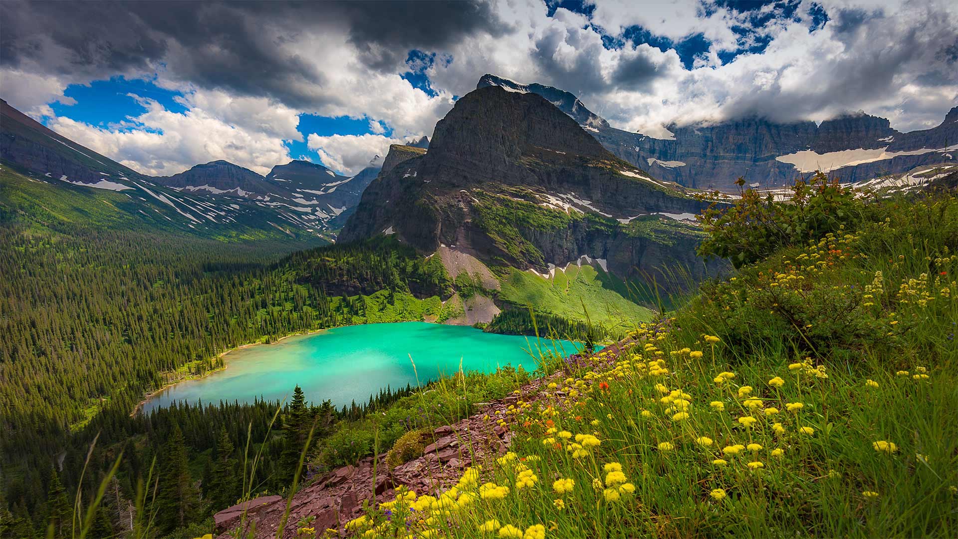
格林内尔湖,蒙大拿州冰川国家公园 Grinnell Lake, Glacier National Park, Montana (© Pung/Shutterstock)
'The Crown of the Continent'
With one million acres of rugged, northwestern Montana wilderness to explore, a trip to Glacier National Park could fill up an entire summer and more. But let's just take one day and virtually visit Grinnell Lake. A 7-mile loop trail, a relatively easy one in this rugged country, takes you to the shores of the lake turned emerald-green by glacial silt. Grinnell Lake—as well as Mount Grinnell and Grinnell Glacier—is named for the naturalist and Audubon Society founder George Bird Grinnell. For two decades, he lobbied for the creation of the park, and on May 11, 1910, the 'Crown of the Continent,' as Grinnell dubbed this area, became the nation's 10th national park.
“大陆之冠”
有一百万英亩崎岖不平的蒙大拿州西北部荒野可供探索,一次冰川国家公园之旅可能会填满整个夏天,甚至更多。但让我们花一天时间去参观格林内尔湖吧。在这个崎岖的国家,一条7英里长的环形小径相对容易,它会带你到达湖岸,湖岸被冰川淤泥染成翠绿。格林内尔湖以及格林内尔山和格林内尔冰川是以博物学家和奥杜邦协会创始人乔治·伯德·格林内尔命名的。二十年来,他一直在游说建立这个国家公园,1910年5月11日,格林内尔称之为“欧洲大陆之冠”的这个地区成为美国第十个国家公园。
穆斯黑德湖附近的Norcross Brook河与湿地,缅因州皮斯卡特奎斯 Norcross Brook and wetlands near Moosehead Lake in Piscataquis County, Maine (© Aaron Black-Schmidt/Tandem Stills + Motion)

穆斯黑德湖附近的Norcross Brook河与湿地,缅因州皮斯卡特奎斯 Norcross Brook and wetlands near Moosehead Lake in Piscataquis County, Maine (© Aaron Black-Schmidt/Tandem Stills + Motion
Deep in the North Woods wetlands
To celebrate American Wetlands Month, we're flying over Norcross Brook, which snakes through the wetlands of Maine's North Woods near Moosehead Lake. Wetlands like these are an often-underappreciated natural resource. They act as vital link between land and our planet's watersheds, playing a crucial role in protecting healthy ecosystems. In addition to providing indispensable habitat for the many species that call them home, wetlands filter our drinking water and cycle nutrients. They also provide a natural buffer from storms, absorb flood waters, and capture carbon from the atmosphere—all of which help to mitigate the impact of climate change.
Some of the wetlands here around Moosehead Lake include the West Shirley Bog and the Lazy Tom Bog, both of which are well-known moose-watching hotspots. The hulking animals of Maine's North Woods are so common they're said to outnumber residents three to one. Surely there's a moose or five down there among those trees…
在北部森林湿地深处
为了庆祝美国湿地月,我们将飞越诺克罗斯布鲁克,它蜿蜒穿过缅因州北部穆塞黑德湖附近森林的湿地。像这样的湿地是一种常常被低估的自然资源。它们是连接陆地和地球分水岭的重要纽带,在保护健康的生态系统方面发挥着至关重要的作用。除了为许多称之为家的物种提供不可或缺的栖息地外,湿地还过滤我们的饮用水,循环营养物质。它们还提供了风暴的自然缓冲,吸收洪水,从大气中捕获碳,所有这些都有助于减轻气候变化的影响。
穆塞黑德湖周围的一些湿地包括西雪莉沼泽和懒惰的汤姆沼泽,这两个地方都是著名的麋鹿观赏热点。缅因州北部森林的笨重动物非常常见,据说它们的数量比当地居民多出三倍。在那些树中间肯定有一两只麋鹿…
托塞加尔瀑布,印度马哈拉施特拉邦 Thoseghar Waterfalls in Maharashtra, India (© Sonali Kumar/iStock/Getty Images Plus)
托塞加尔瀑布,印度马哈拉施特拉邦 Thoseghar Waterfalls in Maharashtra, India (© Sonali Kumar/iStock/Getty Images Plus)
The roaring waterfalls…
Situated at the edge of the Konkan region in Maharashtra, India, the waterfall is formed of many small streams flowing from Panchgani and Mahabaleshwar and a series of other waterfalls that sprout up during the monsoon season. The sight of the waterfall is magical! You get to see the water swishing over the rocks joyfully. It thunders down into a pool like a gigantic waterspout, making a roaring sound. Needless to say, the place is rich in flora and fauna and you can see the species of exotic and local birds that you would have never seen before.
Another reason for featuring this beautiful waterfall today is that we are celebrating Maharashtra Day. On this day in 1960, Maharashtra gained statehood after the division from the Bombay State.
咆哮的瀑布…
瀑布位于印度马哈拉施特拉邦孔坎地区的边缘,由潘奇加尼和马哈巴利什瓦尔的许多小溪和一系列其他瀑布组成,这些瀑布在季风季节萌生。瀑布的景色真神奇!你可以看到水在岩石上欢快地晃动。它像一个巨大的水龙卷一样,雷鸣般地落到一个池塘里,发出轰鸣的声音。不用说,这里有丰富的动植物群,你可以看到你从未见过的外来鸟类和本地鸟类。
另一个原因是我们今天要庆祝马哈拉施特拉邦日。1960年的这一天,马哈拉施特拉邦在脱离孟买州之后获得了国家地位。
乔鲁拉大金字塔,墨西哥乔鲁拉 The Great Pyramid of Cholula, in Cholula, Puebla, Mexico (© mauritius images GmbH/Alamy)

乔鲁拉大金字塔,墨西哥乔鲁拉 The Great Pyramid of Cholula, in Cholula, Puebla, Mexico (© mauritius images GmbH/Alamy)
The birthplace of Cinco de Mayo
The church we see on the grassy hill was built after Hernan Cortez and his Spanish army conquered Cholula one October day in 1519. The Spanish ravaged the holy city that day, murdering 10% of its population and burning down the many pyramids that dotted the area. But just underneath this church, buried for centuries, lay an ancient secret never discovered by the Spanish. It's the largest pyramid in the world, the Great Pyramid of Cholula, so large its enormous base would span several Olympic-sized swimming pools.
It's apt then, that we visit this holy area on Cinco de Mayo. Just 20 miles away near the city of Puebla, on May 5, 1862, another battle was waged, this time by the Mexicans against French invaders. By some miracle, the vastly outnumbered and outarmed Mexicans won the Battle of Puebla. And so today, we in the United States join those in this part of Mexico to celebrate a win over would-be conquerors.
Cinco de Mayo的诞生地
我们在长满青草的山上看到的教堂是在1519年10月的一天,赫尔南·科尔特斯和他的西班牙军队征服了乔鲁拉之后建造的。西班牙人那天蹂躏了圣城,杀害了10%的人口,烧毁了遍布该地区的许多金字塔。但就在这座埋葬了几个世纪的教堂下面,隐藏着一个从未被西班牙人发现的古老秘密。它是世界上最大的金字塔,乔鲁拉大金字塔,如此之大,其巨大的基础将跨越几个奥运会大小的游泳池。
那么,我们去参观辛科德梅奥的这片圣地是恰当的。1862年5月5日,就在20英里外的普埃布拉市附近,墨西哥人发动了另一场战争,这次是对法国侵略者的战争。奇迹般的是,人数众多、装备精良的墨西哥人赢得了普埃布拉战役。所以今天,我们美国和墨西哥这一地区的人们一起庆祝战胜潜在征服者的胜利。