2021年4月
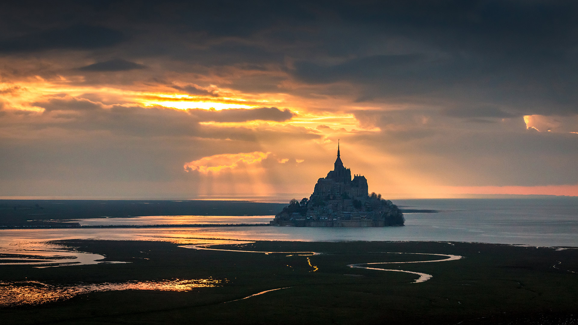
处于美轮美奂的光影中的圣米歇尔山 (© Mathieu Rivrin/Getty Images)
鸟瞰Mockhorn岛野生动植物管理区沼泽地内的潮汐通道,弗吉尼亚 Aerial view of tidal channels in marshland of the Mockhorn Island State Wildlife Management Area, Virginia (© Shane Gross/Minden Pictures)
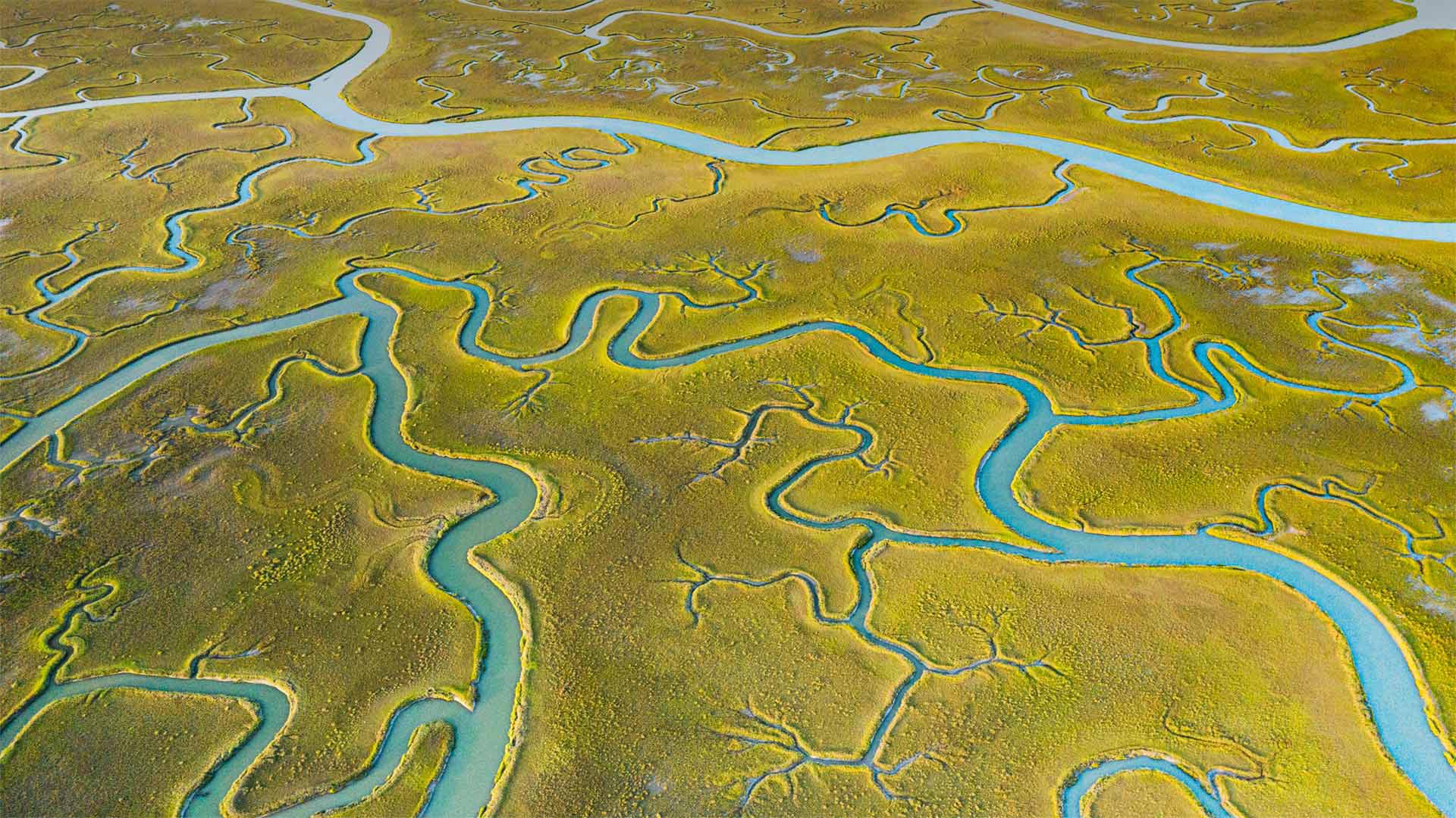
鸟瞰Mockhorn岛野生动植物管理区沼泽地内的潮汐通道,弗吉尼亚 Aerial view of tidal channels in marshland of the Mockhorn Island State Wildlife Management Area, Virginia (© Shane Gross/Minden Pictures)
When does the tide come in?
From the air, this tract of Mockhorn Island on the Atlantic coast of Virginia's Eastern Shore could pass for gentle farmland. But what you're really looking at is rugged tidal marshland, visible when the tide is out—the rest of the time, much of this area is underwater. Mockhorn is itself part of Virginia's coastal island chain called the Barrier Islands, which run down the east coast of the state from the Maryland-Delaware border for about 70 miles, stretching to the mouth of Chesapeake Bay. The green vegetation you see is grass, although not the kind you'll find in a suburban lawn. Instead, it's saltmarsh cordgrass, a type of perennial deciduous species that grows in wetlands and salt marshes like this one.
The only way to access the tidal channels of Mockhorn Island is by boat, and plenty of kayakers, hunters, and sport fishers are willing to brave the fickle, windy weather to enjoy the island's labyrinth of sloughs, bays, and inlets. The area's also a great destination for bird watchers, as many bird species fly directly overhead while migrating. Historically, the rugged terrain and remote location of the Barrier Islands made them a great place for those running from the authorities—it's said that pirates, including Blackbeard himself, spent time in hiding in the backwaters of this rugged coast.
潮水什么时候来?
从空中看,这片位于弗吉尼亚东岸大西洋海岸的莫克霍恩岛可以算是一片温和的农田。但你真正看到的是崎岖不平的潮汐沼泽地,其余时间退潮时可见,这一地区大部分都在水下。莫克霍恩岛本身是弗吉尼亚州海岸岛链的一部分,称为障壁群岛,从马里兰州与特拉华州的边界沿该州东海岸延伸约70英里,一直延伸到切萨皮克湾的河口。你看到的绿色植被是草,虽然不是你在郊区草坪上看到的那种。取而代之的是盐沼灯心草,一种多年生落叶植物,生长在湿地和盐沼中。
进入莫克霍恩岛潮汐通道的唯一途径是乘船,许多皮划艇手、猎人和运动渔民都愿意冒着变化无常、刮风的天气,享受岛上迷宫般的泥沼、海湾和水湾。该地区也是鸟类观察者的好去处,因为许多鸟类在迁徙时直接从头顶飞过。从历史上看,障壁岛崎岖的地形和偏远的地理位置使它成为那些逃避当局的人的好去处。据说海盗,包括黑胡子本人,都在这个崎岖的海岸的穷乡僻壤中躲藏了一段时间。
文斯利代尔,英格兰约克郡谷地国家公园 Wensleydale, Yorkshire Dales National Park, North Yorkshire, England (© Guy Edwardes/Minden Pictures)
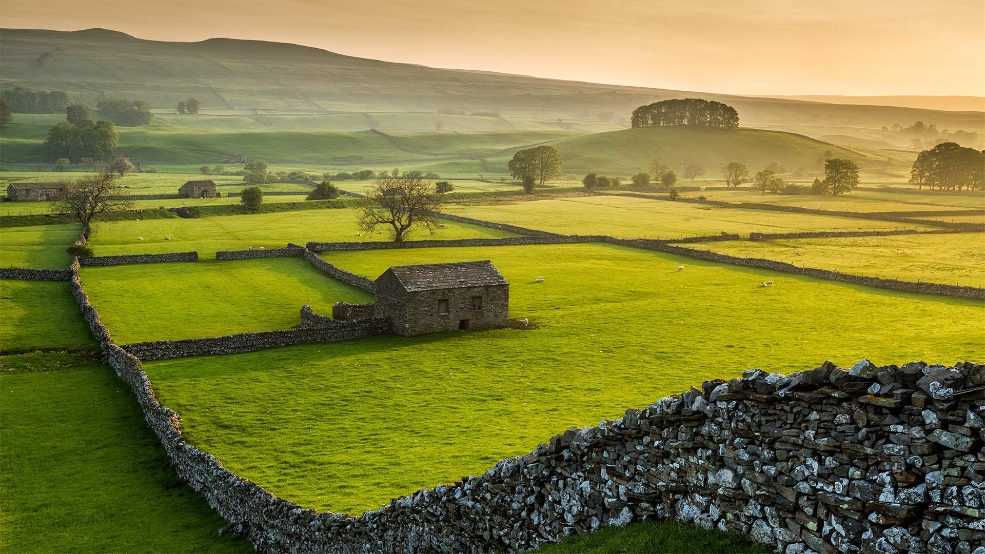
文斯利代尔,英格兰约克郡谷地国家公园 Wensleydale, Yorkshire Dales National Park, North Yorkshire, England (© Guy Edwardes/Minden Pictures)
'Cheese! We'll go somewhere where there's cheese!'
Ahh, the pastoral countryside of the Yorkshire Dales in Northern England. Dewey mornings, grazing farm animals, hand-built dry stone walls, and…cheese? Well, if you're a fan of the beloved British claymation series 'Wallace & Gromit,' then you may have first heard of this area of the Yorkshires, Wensleydale, because of its local cheese. In fact, the animated duo's notorious affinity for the local curd--which Wallace likes because producers thought it makes his face look 'nice and toothy'—became so widespread that it helped the Wensleydale cheesemakers stave off bankruptcy.
Cheese aside, another staple of Wensleydale, and the surrounding Yorkshire Dales National Park, are the 5,000 miles of dry stone walls that have crisscrossed the landscape for centuries. The walls were built by farmers to delineate boundaries, clarify land ownership, and more practically, to keep their cows and sheep from wandering off. The walls are considered 'dry' because they were built with no mortar to bind the stones together. Larger stones form a base for the wall, upon which smaller stones are stacked to create two parallel wall faces, constructed simultaneously. More stones are then used to fill in the gap between the two wall faces, with gravity doing the rest. While that may sound flimsy, a well-constructed dry stone wall can last at least 100 years.
“奶酪!我们要去有奶酪的地方
啊,英格兰北部约克郡山谷的田园乡村。杜威的早晨,放牧的农场动物,手工建造的干石墙,还有……奶酪?好吧,如果你是一个喜爱的英国粘土系列'华莱士和格罗米特'的粉丝,那么你可能第一次听说这个地区的约克郡,温斯莱代尔,因为它的当地奶酪。事实上,这对动画片中的二人组对当地乳酪臭名昭著的亲和力——华莱士喜欢这种乳酪,因为制作人认为这种乳酪能让他的脸看起来“又漂亮又有牙齿”——变得如此广泛,这帮助温斯利代尔奶酪制造商避免了破产。
除了奶酪之外,温斯莱代尔的另一大主食,以及周围的约克郡戴尔国家公园,都是绵延5000英里的干石墙,几个世纪以来,这些石墙纵横交错。这些围墙是由农民建造的,目的是划定边界,明确土地所有权,更实际的是,防止他们的牛羊四处游荡。这些墙被认为是“干的”,因为它们建造时没有用砂浆将石头粘合在一起。较大的石头形成墙的基础,较小的石头堆放在上面,形成两个平行的墙面,同时建造。然后用更多的石头填充两个墙面之间的缝隙,剩下的部分由重力来完成。虽然这听起来很脆弱,但一座建造良好的干石墙至少可以使用100年。
从冰山跃入水中的阿德利企鹅,南极 Adélie penguins diving off an iceberg in Antarctica (© Mike Hill/Getty Images)
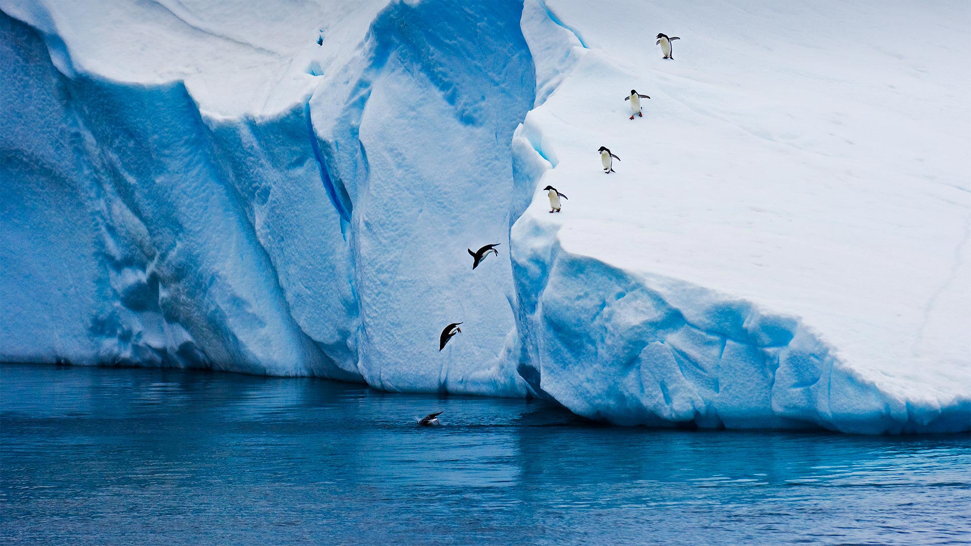
从冰山跃入水中的阿德利企鹅,南极 Adélie penguins diving off an iceberg in Antarctica (© Mike Hill/Getty Images)
One giant leap for penguins
These Adélie penguins are jumping for joy because it's World Penguin Day. Or maybe they're just looking for a snack as they dive off this iceberg. Adélies live on Antarctica and nearby islands all year long, but in the fall and winter they spend most of their time near the coast. They can dive as deep as 575 feet or travel as much as 185 miles to find krill, fish, and squid.
The smallest penguin in the Antarctic, Adélies are one of only two penguin species (the other is the Emperor penguin) that live exclusively on the Antarctic continent. Huge colonies of Adélies were once spread throughout the Antarctic Peninsula and the coastline of the continent, but as climate change took hold, populations declined in some areas. Fortunately, a robust colony of some 1.5 million Adelie penguins was found on the Antarctic Peninsula's Danger Islands.
企鹅的一次大跃进
这些广告é因为今天是世界企鹅日,所以企鹅们高兴得跳起来。或者他们只是在从冰山上跳下去的时候找点吃的。广告é它们终年生活在南极洲和附近的岛屿上,但在秋天和冬天,它们大部分时间都在海岸附近。它们可以潜到575英尺深或185英里深的地方寻找磷虾、鱼和鱿鱼。
南极最小的企鹅,公元é谎言是只生活在南极大陆的两种企鹅物种之一(另一种是帝企鹅)。大量的广告é谎言一度蔓延到整个南极半岛和该大陆的海岸线,但随着气候变化,一些地区的人口减少。幸运的是,在南极半岛的危险岛上发现了一个由大约150万只阿德利企鹅组成的健壮的群体。
Casa Batlló in Barcelona, Catalonia, Spain 巴特洛公寓, 在巴塞罗那, 加泰罗尼亚, 西班牙 (© Marco Arduino/Sime/eStock Photo)
Casa Batlló in Barcelona, Catalonia, Spain 巴特洛公寓, 在巴塞罗那, 加泰罗尼亚, 西班牙 (© Marco Arduino/Sime/eStock Photo)
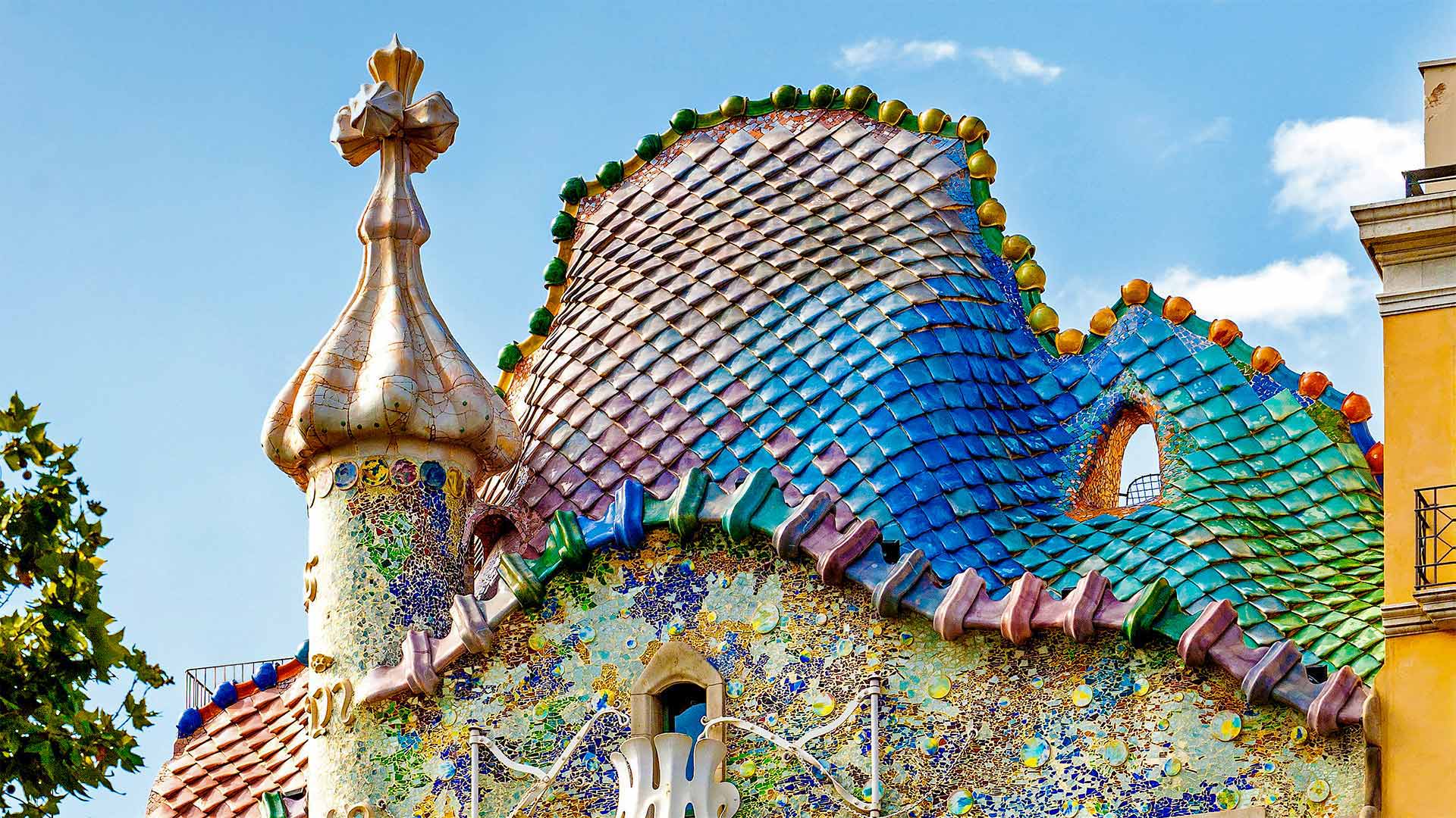
A house of grand scale(s)
We're looking at the rooftop of Casa Batlló, a 6-story building in the center of Barcelona topped with colorful 'scales.' What brings us here? Well, here in Spain's province of Catalonia, and in several other locales from England to Ethiopia, it's the feast of Saint George. You know George (or Jordi, as the Catalans call him): He's the knight who, legend holds, saved a much-loved princess by defeating a fierce dragon. It's said the tower jutting from the Casa's tiled roof represents George's lance thrust into the monster's scaly back.
George is Catalonia's patron saint—but the designer of Casa Batlló's façade could be called the land's patron architect. Antoni Gaudí designed dozens of buildings around Barcelona in matching fashion: bold fairy-tale designs with curvy constructions and vibrant colors. Gaudí's long-unfinished masterpiece, the famous Sagrada Família cathedral, is set to be completed in 2026, a century after his passing.
大房子
我们在看Casa Batll的屋顶ó, 巴塞罗那市中心的一座6层楼高的建筑,上面有五颜六色的“鳞片”。什么风把我们吹来了?嗯,在西班牙的加泰罗尼亚省,以及从英国到埃塞俄比亚的其他几个地方,这是圣乔治的盛宴。你知道乔治(或者加泰罗尼亚人叫他乔迪):传说中,他是一位骑士,他打败了一条凶猛的龙,拯救了一位深受爱戴的公主。据说这座塔从木屋的瓦片屋顶伸出,代表着乔治的长矛插进了怪物鳞片般的背部。
乔治是加泰罗尼亚的守护神,但卡萨巴特尔的设计师ó's fa公司ç艾德可以被称为这片土地的赞助人建筑师。安东尼·高德í 在巴塞罗那周围设计了几十座建筑,风格搭配:大胆的童话设计,弯曲的结构和鲜艳的色彩。高德í'他的长篇未完成的杰作,著名的萨格拉达家族í在他去世一个世纪后,西伯利亚大教堂将于2026年竣工。
贝图瑟科伊德的Fairy Glen,英国威尔士 (© Robert Harding World Imagery/Offset by Shutterstock)
位于阿肯色州和密西西比州交界处的密西西比河 Mississippi River on the border between Arkansas and Mississippi (© NASA)
位于阿肯色州和密西西比州交界处的密西西比河 Mississippi River on the border between Arkansas and Mississippi (© NASA)
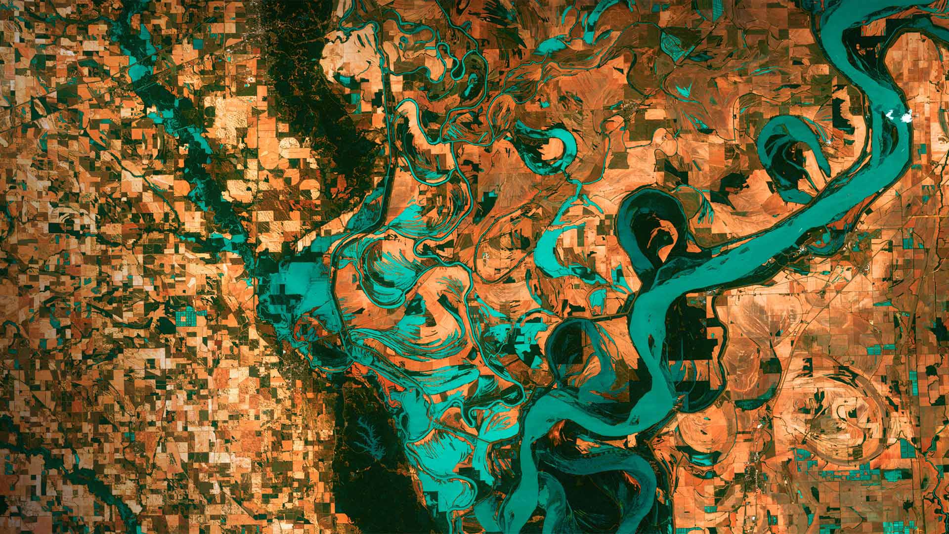
Gazing down on planet Earth
It's Earth Day today and we are high above the blue marble looking down on the border between Arkansas and Mississippi. Those small, blocky shapes are towns, fields, and pastures–the teal green is the mighty Mississippi River. Anyone who has flown in the window seat of an airplane and has gazed down at Earth below might wonder why the colors in this image are so unreal. That's because they are. These images were taken in 2013 by Landsat 7, a NASA satellite that uses thermal infrared sensors to help scientists better distinguish flora, fauna, water, and manmade objects. For almost 50 years, NASA has been using satellite imagery to understand how climate change and population growth are affecting our fragile planet. These satellites help NASA see where deforestation and wildfires are happening, where glaciers are melting, and how rising waters are encroaching on cities.
The biggest cause of these changes? According to NASA, it's us. Since the first Landsat launched in 1972, the Earth's population has almost doubled, from 4 billion people then to 7.8 billion today. But there is some good news to mark this Earth Day: The Mississippi River we see here is much less toxic now than it was back in 1972, thanks to environmental laws and regulations.
俯瞰地球
今天是地球日,我们在阿肯色州和密西西比州交界处的蓝色大理石上方俯瞰。那些小而块状的形状是城镇、田野和牧场——青绿色是浩瀚的密西西比河。任何坐过飞机靠窗座位的人,都可能会想,为什么这张照片中的颜色如此不真实。那是因为他们是。这些图像是2013年由美国宇航局的陆地卫星7号拍摄的,该卫星使用热红外传感器帮助科学家更好地区分动植物、水和人造物体。近50年来,美国宇航局一直在利用卫星图像来了解气候变化和人口增长是如何影响我们这个脆弱的星球的。这些卫星有助于美国宇航局了解森林砍伐和野火正在发生的地方,冰川正在融化的地方,以及上涨的海水如何侵蚀城市。
这些变化的最大原因是什么?据美国宇航局说,是我们。自从1972年第一颗陆地卫星发射以来,地球人口几乎翻了一番,从当时的40亿人增加到今天的78亿人。但是,有一些好消息值得纪念这个地球日:由于环境法律和法规,我们在这里看到的密西西比河现在的毒性比1972年时要小得多。
马德拉岛的北海岸,葡萄牙 The north coast of Madeira, Portugal (© Hemis/Alamy)
马德拉岛的北海岸,葡萄牙 The north coast of Madeira, Portugal (© Hemis/Alamy)
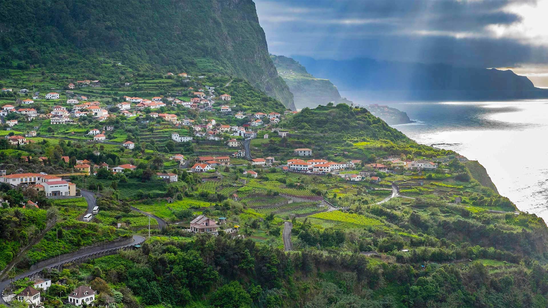
Exploring the 'Pearl of the Atlantic'
We're taking a view of the island of Madeira, by far the largest island in the Madeira archipelago, which sits 320 miles off the coast of Morocco in the North Atlantic. Part of an autonomous region of Portugal, Madeira, known as the 'Pearl of the Atlantic,' boasts a diverse forest ecosystem, endemic flora and fauna, and the largest living stand of laurel trees in the world. It's a great place to hike, too. Trails run alongside irrigation channels, called levadas, that move water all over the island. Walks range from easy strolls in the countryside to precarious hikes along mountain ridges or into remote parts of the forests. Afterward, the calorie-depleted can dig into a local delicacy like peixe espada com banana (fried local fish with banana) and sip on Madeira wine. Saúde!
探索“大西洋明珠”
我们正在观看马德拉岛,这是迄今为止马德拉群岛中最大的岛屿,位于北大西洋摩洛哥海岸320英里外。作为葡萄牙自治区的一部分,被称为“大西洋明珠”的马德拉拥有多样化的森林生态系统、特有的动植物群和世界上最大的活月桂林。这也是徒步旅行的好地方。小径沿着被称为levadas的灌溉渠延伸,这些灌溉渠将水输送到全岛。散步的范围从乡村的轻松漫步到沿着山脊或进入森林偏远地区的危险徒步旅行。之后,消耗掉的热量可以吃到当地的美味,比如peixe espada com香蕉(用香蕉炸当地鱼),然后啜饮马德拉葡萄酒。萨乌德!
乌布德格拉朗梯田,印度尼西亚巴厘岛 Tegalalang Rice Terraces, Ubud, Bali, Indonesia (© Michele Falzone/Alamy)
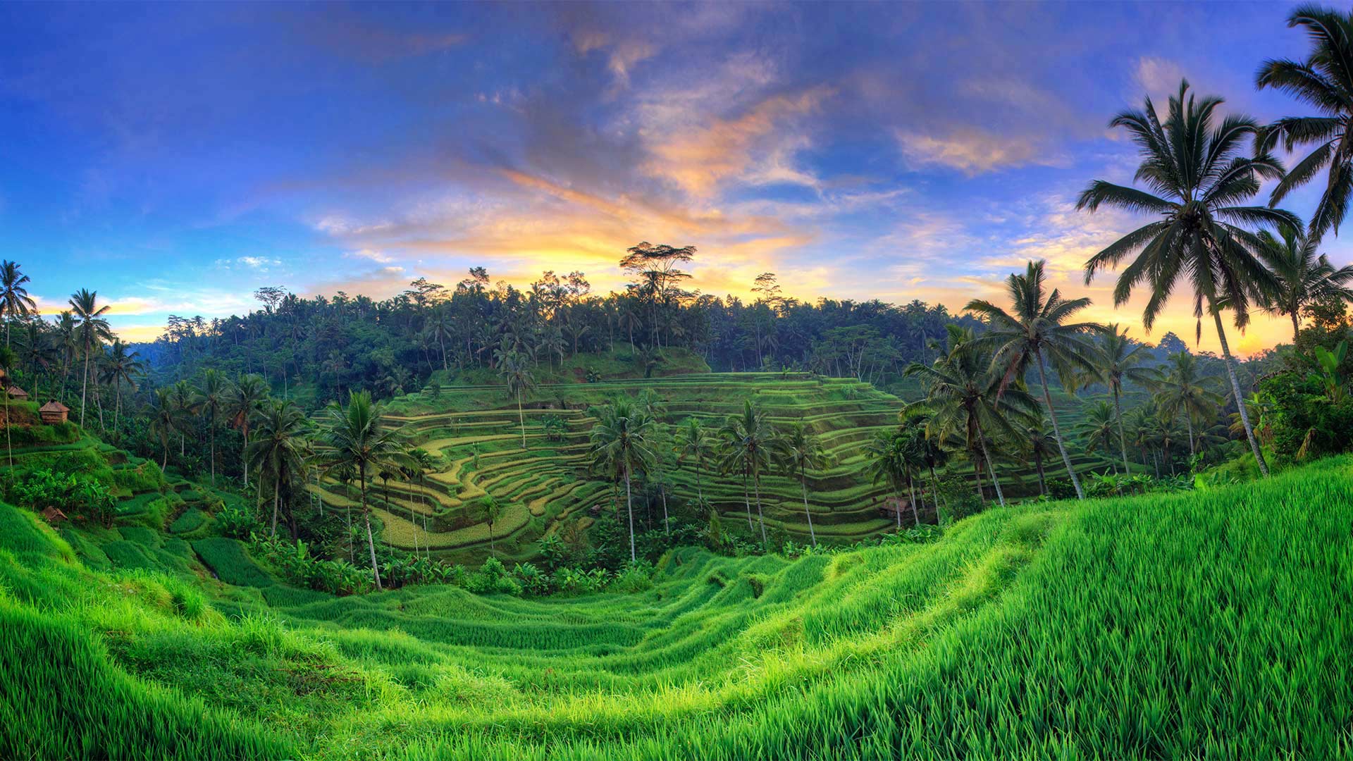
乌布德格拉朗梯田,印度尼西亚巴厘岛 Tegalalang Rice Terraces, Ubud, Bali, Indonesia (© Michele Falzone/Alamy)
Terraced fields of green
Twice a year, all of Bali, Indonesia—including those who live and work in the lush, green rice terraces you see here—join together to celebrate the country's most important holiday, Galungan. This 10-day Balinese-Hindu milestone always comes at the end of the traditional 210-day Balinese calendar, usually in March or April, and then again in September or October.
This spring, the festivities began on April 14, and on that day the Balinese invited the spirits of their ancient ancestors into their homes with prayers and other offerings draped from bamboo poles called penjor, which seem to be erected everywhere. Planted in the ground at individual homes or along the sides of roads and decorated with coconut leaves and flowers, penjor are used to hang offerings as a kind gesture towards the spirits. The tenth and final day of Galungan is called Kuningan, which comes on April 24 this year. To mark this finale, a specially prepared yellow rice will be offered to the departing ancestors, a gift to accompany them on their return journey to the spirit world.
绿色梯田
每年两次,印度尼西亚巴厘岛—包括那些住在这里绿油的梯田里生活和工作的人—一起庆祝这个国家最重要的节日,加尔隆根。这10天的巴厘印度教里程碑总是在传统的210天巴厘历的结束,通常是在3月或4月,然后在9月或10月再次出现。
今年春天,节日从4月14日开始,那天巴厘人邀请他们古老祖先的灵魂们到他们的家里,祈祷和其他祭品都是用竹竿做成的,这些竹竿上挂着,这些祭品似乎到处都是竖立的。彭若尔种植在单独的家里或道路的两侧,用椰子叶和鲜花装饰,用来悬挂祭品,作为对灵魂的一种亲切的姿态。高龙根的第十天也是最后一天,叫做昆ingan,今年4月24日。为了纪念这一结局,将向离世的祖先赠送一份特制的黄米,作为陪伴他们返回精神世界的礼物。
大群的芒基蝠鲼跃出水面,墨西哥加利福尼亚湾 Large school of Munk's pygmy devil rays from the air, Gulf of California, Mexico (© Mark Carwardine/Minden Pictures)
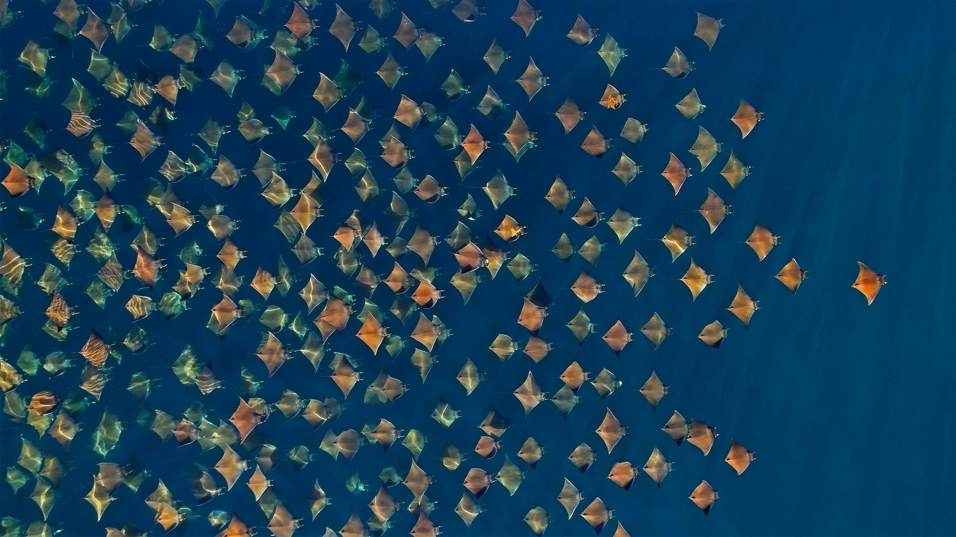
大群的芒基蝠鲼跃出水面,墨西哥加利福尼亚湾 Large school of Munk's pygmy devil rays from the air, Gulf of California, Mexico (© Mark Carwardine/Minden Pictures)
Rays on parade
The feeding frenzy is on! Each spring and fall, the waters off Mexico's Baja California peninsula become the perfect place to spot Munk's devil rays in massive schools like this one. Unlike stingrays (and perhaps the devil), devil rays lack fearsome pointy tails. In fact, these giants—whose wingspans can reach about 9 feet—are pretty gentle all around, feeding mainly on plankton. And for them, mealtime is party time: During huge devil ray gatherings like this, rays are seen continually bursting out of the water and landing with loud bellyflops.
射线在游行
喂食狂潮开始了!每年春天和秋天,墨西哥下加利福尼亚半岛附近的水域都会成为在像这样的大型学校里发现芒克魔鬼鱼的最佳地点。不像黄貂鱼(也许还有魔鬼),魔鬼鱼没有可怕的尖尾巴。事实上,这些翼展能达到9英尺左右的巨型生物四周都很温和,主要以浮游生物为食。对他们来说,进餐时间是聚会时间:在这样的大型魔鬼鱼聚会上,可以看到鱼不断地从水里迸发出来,并带着响亮的肚脐落地。