2020年8月
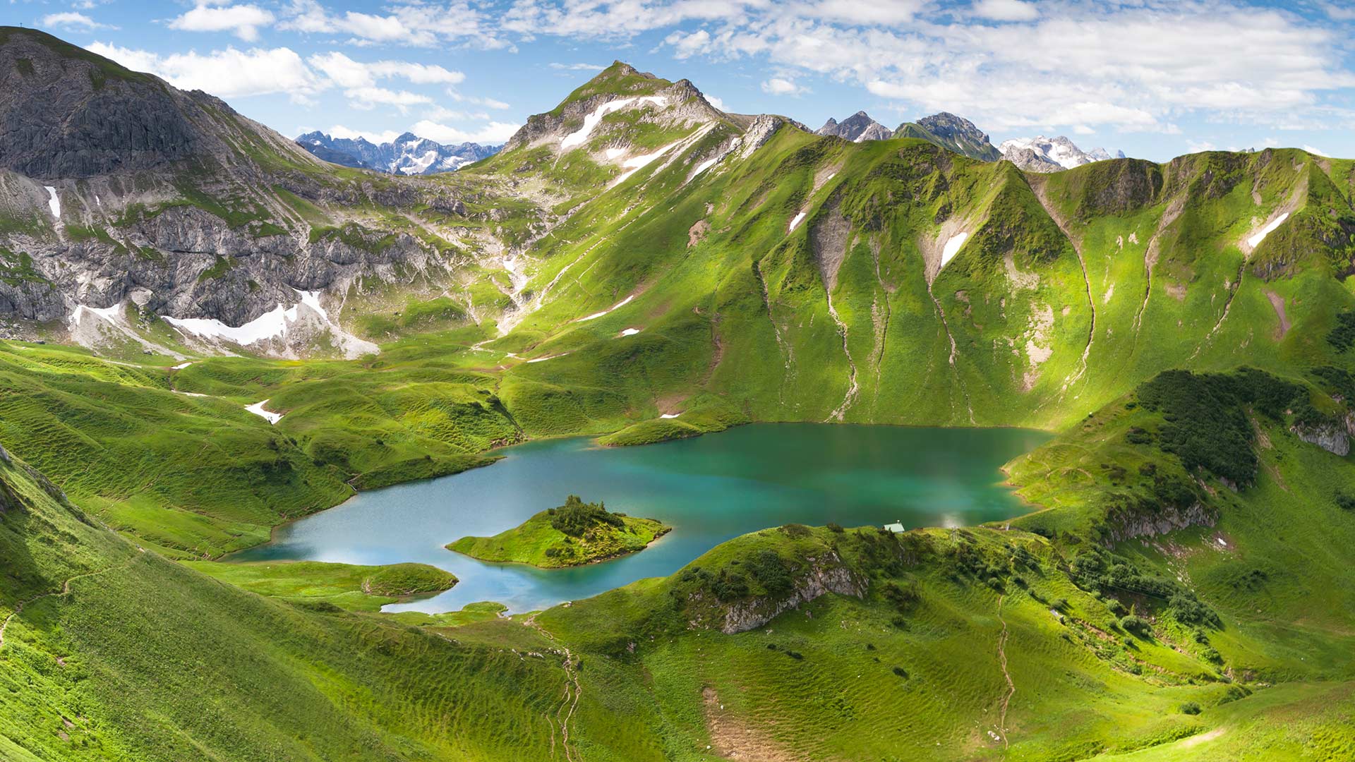
巴伐利亚州Schrecksee湖的全景图,德国 (© wingmar/E+/Getty Images)
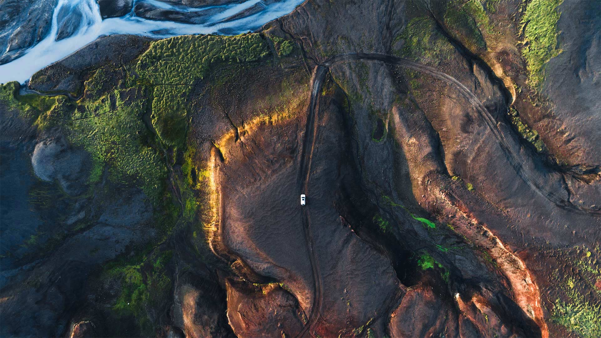
冰岛高地 The Highlands of Iceland (© Kevin Krautgartner/Offset by Shutterstock)
冰岛高地 The Highlands of Iceland (© Kevin Krautgartner/Offset by Shutterstock)
Up in the Highlands
There's a good chance that occupants of that car you can see in this photo, winding along a remote highway in the Highlands of Iceland, won't encounter any other visitors to this desolate region. Accessible only during the summertime, the Icelandic Highlands is a volcanic desert. Frequent volcanic activity in the area creates a porous topsoil full of chemical compounds that aren't conducive to plant growth. Besides, much of the rainfall is quickly absorbed so plant life only appears alongside glacial rivers. Despite this seemingly unwelcome environment, adventurous travelers come to the Highlands every summer to see firsthand an ecosystem so unearthly that NASA conducted training missions here for some of its Apollo astronauts.
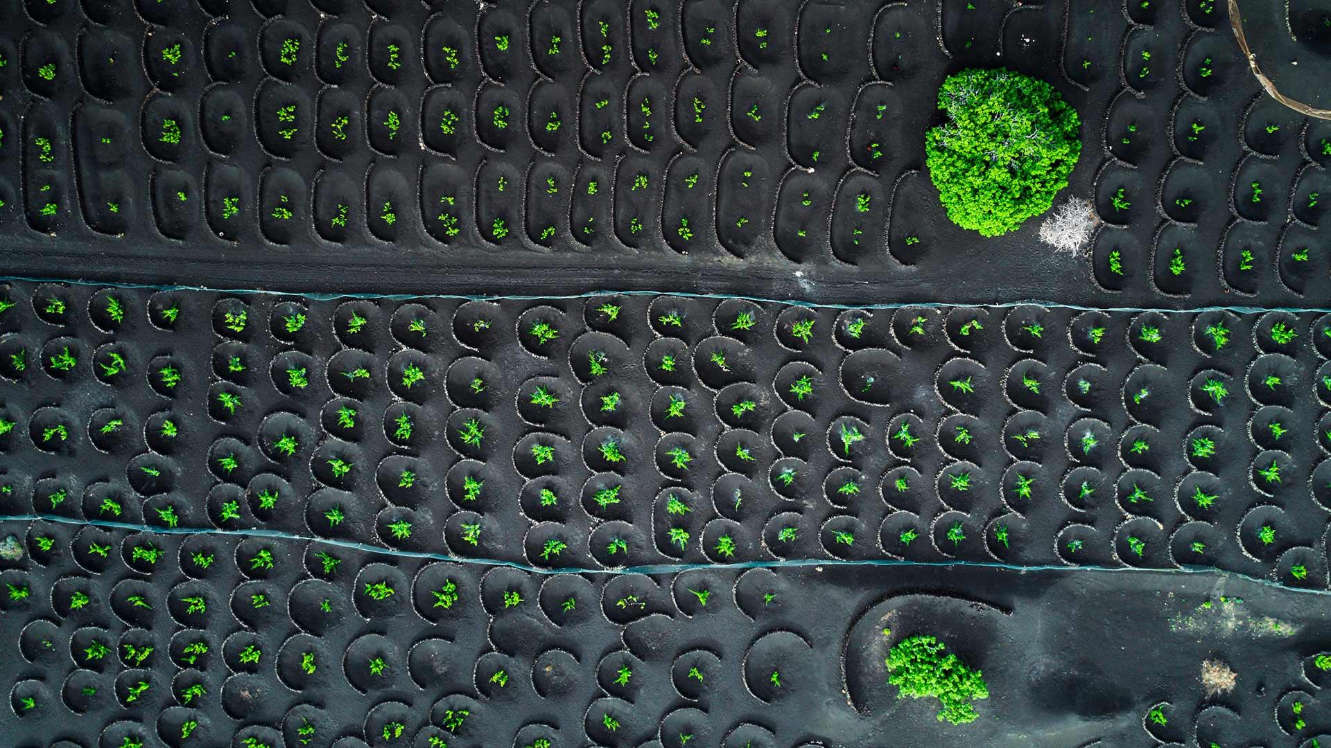
鸟瞰兰萨罗特岛的La Geria葡萄园,西班牙加那利群岛 Aerial view of La Geria vineyards, Lanzarote, Canary Islands, Spain (© Orbon Alija/Getty Images)
鸟瞰兰萨罗特岛的La Geria葡萄园,西班牙加那利群岛 Aerial view of La Geria vineyards, Lanzarote, Canary Islands, Spain (© Orbon Alija/Getty Images)
Volcanic vineyards
What you can see today in our picture is a bird view of La Geria vineyards, in the Canary island of Lanzarote. They have been there since 18th century and are cultivated following a very special technique, because the vines are planted under the volcanic lapilli, a blanket of ash about two and a half meters thick that covers the land since Timanfaya volcano erupted in 1730 transforming the landscape forever.
To reach the fertile soil, farmers first dig a cone-shaped hole and then build a small stone wall to protect the vines from the trade winds. And since the volcanic ash on the surface prevents rainwater evaporation and captures environmental moisture, plants do not even need added watering.
The variety the most cultivated in this place is volcanic Malvasia, a very special and also very delicate white grape allowing both dry and sweet wines. Due to its unique characteristics, La Geria has also been a protected area since 1987, just as the neighbour Timanfaya National Park, where you can see up to 25 volcanoes concentrated in 51 square kilometers.
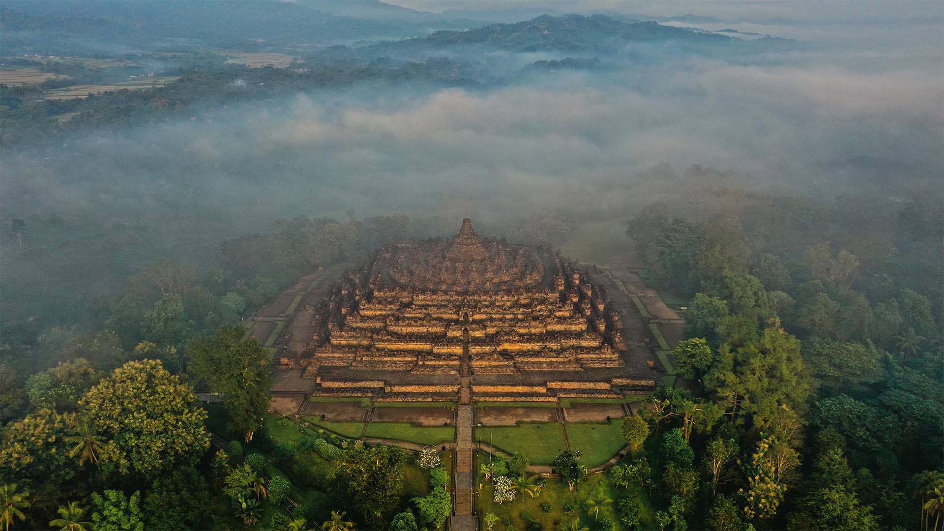
中爪哇省的婆罗浮屠,印度尼西亚 Borobudur in Central Java, Indonesia (© Oleh Slobodeniuk/Getty Images)
中爪哇省的婆罗浮屠,印度尼西亚 Borobudur in Central Java, Indonesia (© Oleh Slobodeniuk/Getty Images)
A giant relic in Java
This photo shows the quiet, mist-shrouded wilderness surrounding the Buddhist temple known as Borobudur. The site is among the most-visited attractions on the island of Java, with devout practitioners making pilgrimages to the holy site and curious tourists coming to see the grandeur of the structure. With 504 Buddha statues and 2,672 sculpted relief panels, Borobudur was likely constructed in the 9th century and abandoned in the 14th as much of the Indonesian population converted from Buddhism and Hinduism to Islam.
Over time it became engulfed by the jungle, and only locals knew of its existence. In the early 1800s, the occupying British administration learned of the temple and sent a Dutch engineer and 200 workers to cut down trees, burn vegetation, and dig away the earth to reveal the monument. Borobudur was eventually restored and given preservation status under UNESCO guidelines.
Life in the nearby town of Muntilan and other Indonesian locales will be even more active than usual on August 17, as that date is Indonesia's Independence Day. The nation of islands at the crossroads of the Indian and Pacific oceans declared independence in 1945 and made the date a national holiday eight years later. The people of Indonesia were freeing themselves from three centuries of Dutch rule.
芬迪湾低潮时的洞穴及海岸地貌 ,加拿大新不伦瑞克 Caves and coastal features at low tide on the Bay of Fundy, near St. Martins, New Brunswick, Canada (© Jamie Roach/Shutterstock)
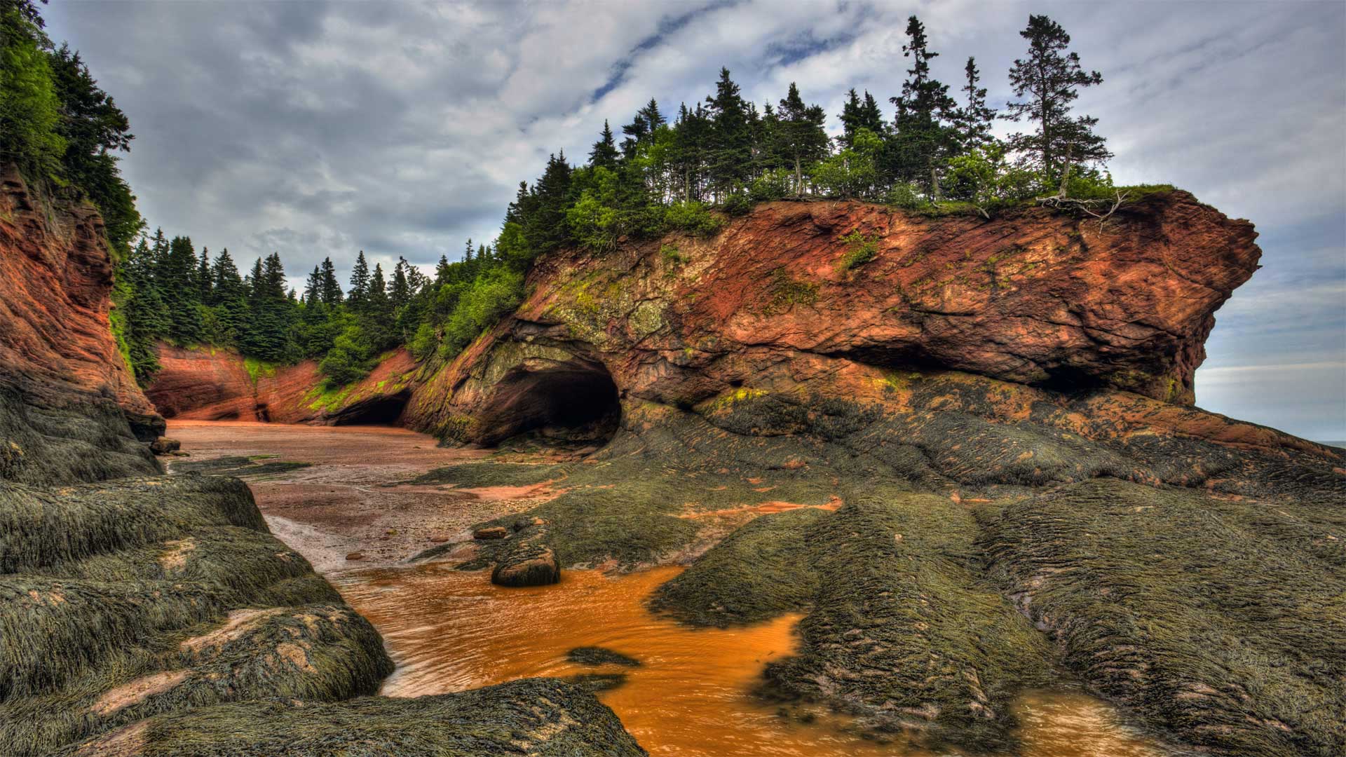
芬迪湾低潮时的洞穴及海岸地貌 ,加拿大新不伦瑞克 Caves and coastal features at low tide on the Bay of Fundy, near St. Martins, New Brunswick, Canada (© Jamie Roach/Shutterstock)
It's National Acadian Day
In honor of Canada's National Acadian Day, we're on the shores of New Brunswick as the ocean recedes to reveal the Bay of Fundy's massive intertidal zone. The tide is a big deal at the bay—more than five times bigger than in most places. Typical tides around the world have a range of 3 to 6 feet, but these waters drop as far as 50 feet from high to low tide.
National Acadian Day celebrates the legacy of the Acadians, Canada's first permanent French residents. The agrarian Acadians first settled what's now Nova Scotia in 1605 and spread to nearby areas, like this one, over that century, developing an identity distinct from the rest of New France. This unfortunately didn't shield them from Old World conflicts as France's longtime enemy, Britain, occupied and tried to conquer Acadia multiple times, finally succeeding in 1710. The British ultimately expelled the Acadians four decades later, a forced relocation to other British colonies where Acadians were often pressed into servitude—or to France, the mother country many Acadians never knew, and to which many wouldn't survive the voyage.
But that tragic chapter is far from the end of the Acadians' story. Some of them eventually returned to Acadia, and their culture still permeates Canada's Maritime provinces—as well as another unlikely locale. Thanks to France's friendly 18th-century relations with Spain, many exiled Acadians were able to settle the then-Spanish-controlled bayous of Louisiana—where 'Acadian' eventually morphed into 'Cajun.'
从亨茨梅萨俯瞰纪念碑谷,亚利桑那州与犹他州之间纳瓦霍族保留地 A view of Monument Valley Navajo Tribal Park from Hunts Mesa, Navajo Nation, between Arizona and Utah (© AWL Images/Danita Delimont)
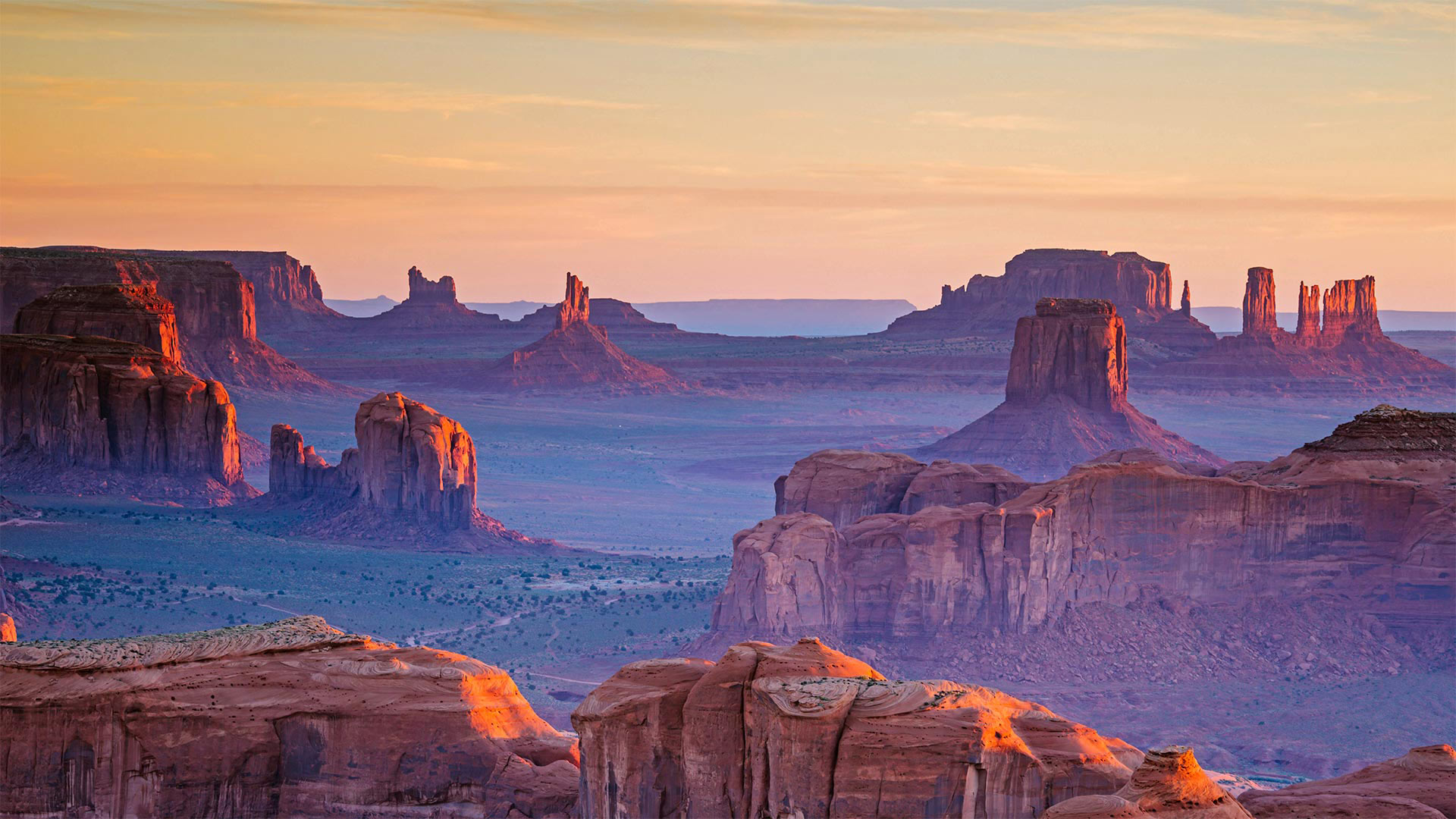
从亨茨梅萨俯瞰纪念碑谷,亚利桑那州与犹他州之间纳瓦霍族保留地 A view of Monument Valley Navajo Tribal Park from Hunts Mesa, Navajo Nation, between Arizona and Utah (© AWL Images/Danita Delimont)
A monumental view of 'Tsé Biiʼ Ndzisgaii'
This expansive and iconic view, taken from Hunts Mesa in the Navajo Nation, is none other than Monument Valley, also known as the Valley of the Rocks when translated from the Navajo language (Tsé Biiʼ Ndzisgaii). The red sandstone formations are synonymous with the American Southwest and have stunned moviegoers for nearly a century. The largest of American Indian territories, Navajo Nation covers more than 27,000 square miles and reaches into portions of Arizona, Utah, and New Mexico.
During World War II, an elite team of Navajos left their homes to join the US Marine Corps and solve a communications challenge. In the Pacific, many of the US combat codes had been cracked by the Japanese army and navy, leaving US troops vulnerable to attack by Axis forces. But in 1942, the first 29 Navajo recruits helped develop a new undecipherable code. They used common words and phrases from their tribal language to convey some messages and created special codes to describe military terms; for instance, various weapons of war were assigned Navajo bird names. Code Talkers could encode, send, and decode a three-line English message text—without error—in roughly 20 to 150 seconds. It took machines of the day at least 30 minutes, sometimes longer, to do the same thing.
Some say the US would not have prevailed at the fiercely fought Battle of Iwo Jima had it not been for the Navajo Code Talkers' contributions. And yet, their contributions would go unknown until the program was finally declassified in 1968. Navajo Code Talkers Day was established on August 14, 1982 to commemorate the elite team as well as other Native Americans and First Nations people who had developed codes used in other conflicts. It's a fascinating history that you can learn more about by taking our quiz.
彩岩国家湖滨区的岩洞,密歇根 Cavern in Pictured Rocks National Lakeshore on Lake Superior, Michigan (© Kenneth Keifer/Getty Images)
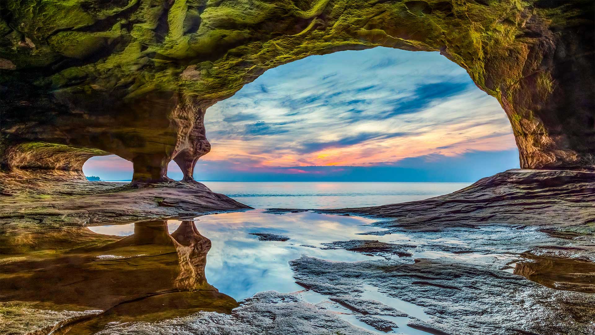
彩岩国家湖滨区的岩洞,密歇根 Cavern in Pictured Rocks National Lakeshore on Lake Superior, Michigan (© Kenneth Keifer/Getty Images)
At the shore of an inland sea
We're looking out from a cavern at Pictured Rocks National Lakeshore in Michigan's Upper Peninsula. The area's named for its colorful sandstone cliffs, which stretch for 15 miles along the shores of the largest of the Great Lakes, Lake Superior. As groundwater leaches out of the rocks, it carries minerals such as iron, manganese, and copper that paint the cliffs in shades of red, pink, black, green, and other colors. The park itself, which is roughly the size of five Manhattans, boasts waterfalls, beaches, and rock formations—some resembling human profiles and castle turrets—carved over time by the relentless waves and unforgiving weather of Yooper Country.
冈山沿岸的发光海洋萤火虫,日本 Bioluminescent sea fireflies along the shore of Okayama, Japan (© tdub_video/Getty Images)
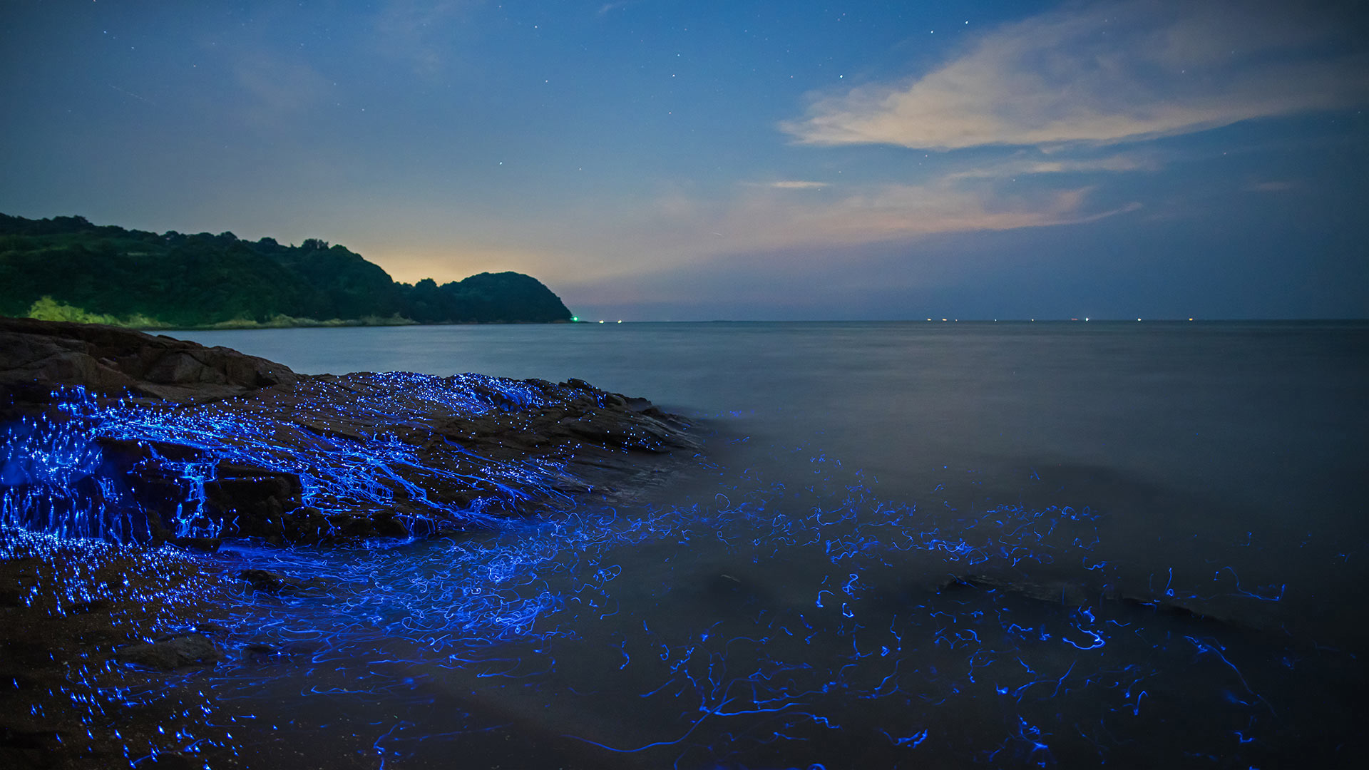
冈山沿岸的发光海洋萤火虫,日本 Bioluminescent sea fireflies along the shore of Okayama, Japan (© tdub_video/Getty Images)
Sea fireflies at the seashore
Sea fireflies may glow like the fireflies that send out backyard beacons at night, but that's about where the similarities end between the two species. Scientists call the bioluminescent crustaceans washing over these rocks Vargula hilgendorfii, and here in Japan they're commonly known as umi-hotaru. They're visible at night in the shallow sea waters and beaches of Japan, although other species of the genus Vargula can be seen glowing in the waters of the Gulf of Mexico, the Caribbean Sea, and off the California coast. Each sea firefly is about the size of a sesame seed, yet as a group they set off an impressive aura. Their glow intensifies depending on the salinity of the sea water and other physical stimuli. Besides lighting up the shores at night, the crustaceans do their part cleaning up the beach by munching on sandworms and dead fish. That's just one less thing for beachcombers to worry about during a glimmering seaside walk.
森火山国家公园中的拉森峰,加利福尼亚 Lassen Peak in Lassen Volcanic National Park, California (© Engel Ching/Shutterstock)
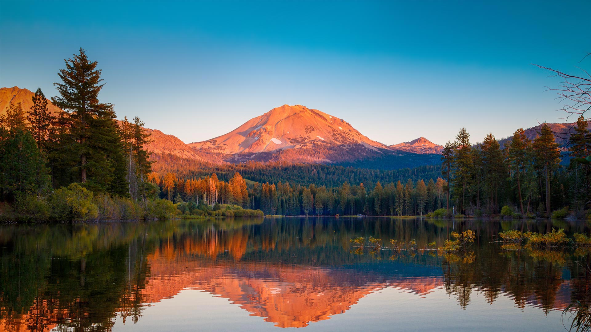
森火山国家公园中的拉森峰,加利福尼亚 Lassen Peak in Lassen Volcanic National Park, California (© Engel Ching/Shutterstock)
A peek at an explosive peak
We're looking at Lassen Peak, a volcano also known as Mount Lassen, and its reflection in Manzanita Lake. This stunning scene can be found in northern California's Lassen Volcanic National Park, which was established on this day in 1916. The volcano erupted between 1914 and 1917 (with some activity as late as 1921), but these days the surrounding area is a calm destination of trails, lakes, and stark lava beds. One of the least visited parks, Lassen was the first national park in California to fully reopen after being closed for COVID-19, although it implemented some restrictions to park services and facilities. The park also includes acres of mud pots, hot springs, steam vents, and fumaroles to remind you of the heat that's below you, including Boiling Springs Lake—one of the largest boiling lakes in the world at over 500 feet wide.
Infinity Bridge in Stockton-on-Tees, England (© Robert Smith/Alamy)
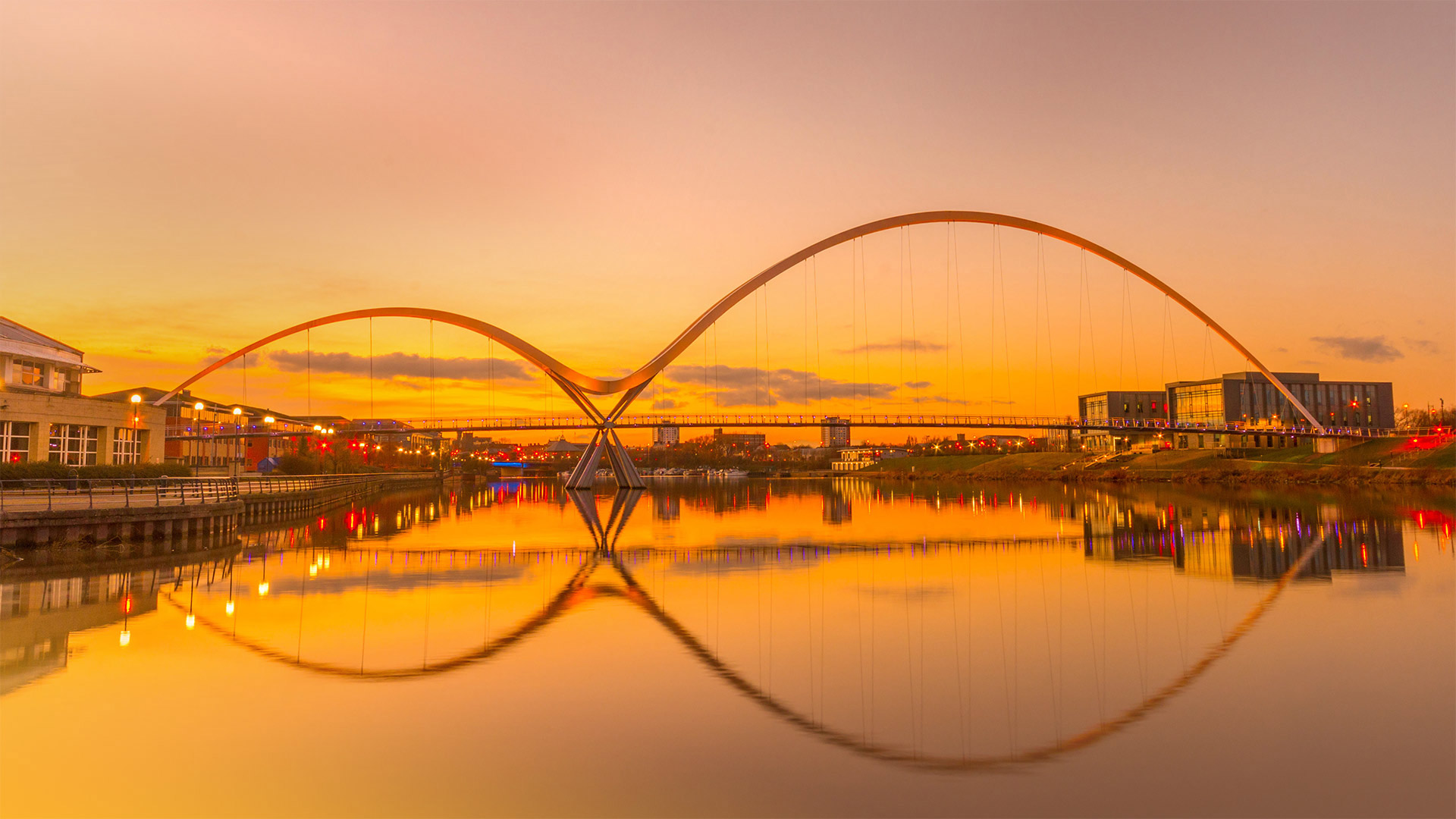
Infinity Bridge in Stockton-on-Tees, England (© Robert Smith/Alamy)
It's ∞ Day!
Gustave Flaubert wrote that 'an infinity of passion can be contained in one minute.' So, if you have boundless passion for contemplating the immeasurable, a full day should offer plenty of time. August 8 (8/8) is Infinity Day since the numeral 8 looks like a tilted ∞, the common symbol for infinity first popularized in 17th-century math books. But the concept of infinity itself represents an idea much older, inherent in the countless spiritual traditions that revere eternal gods or outline endless life cycles.
The bridge in today's image, which carries foot and bike traffic over the River Tees in North East England, wasn't designed with the infinite in mind. But denizens of Stockton-on-Tees thought the tilted figure-eight created by the reflected swooping structure was reminiscent enough of the infinity symbol that city leaders applied the name Infinity Bridge upon the bridge's 2008 completion.